Best Trail Running in Idaho
Trying to find the best trail running in Idaho? Bivy has great hiking, biking, paddling, climbing, skiing, riding and more, with hand-curated trail maps, as well as detailed driving directions.
Idaho, Adams County
04 :17 hrs
5.4 mi
456.6183 ft
Expert
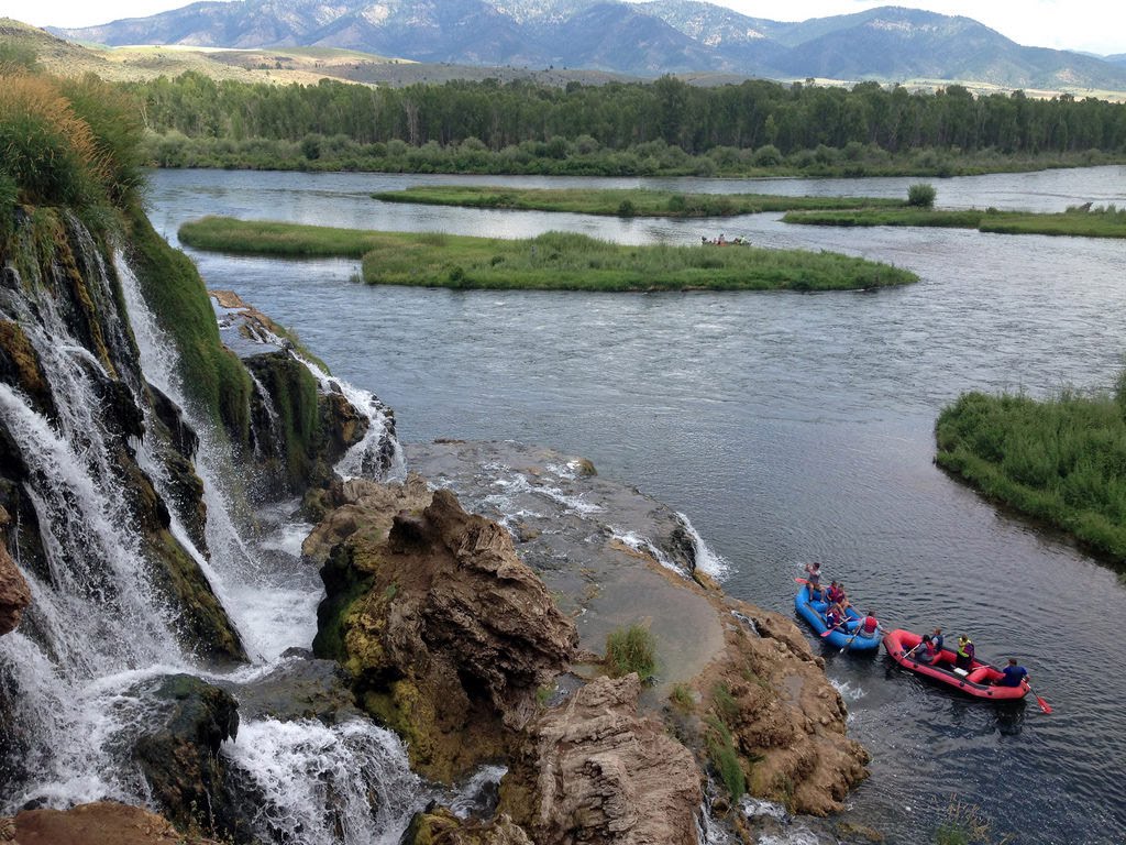
Goose Creek Falls is a great singletrack run that starts at the back of Last Chance Campground near New Meadows. Parking is limited, so you may need to park at the entrance. The run leads through a heavily forested canyon alongside Goose Creek. Watch out for loose rocks and muddy areas around the bridges. The noise of the waterfall will give a good indication that you are getting close. The trail ends at Goose Creek Road, so there is an option to plan a shuttle for a shorter run.
Idaho, Boise County
06 :45 hrs
7.9 mi
1014.922 ft
Expert
The run starts on a steep continuous grade up Cottonwood Creek. Expect a few boggy areas and small creek crossings while tracing towards the ridgetop. The route leads through ponderosa pine trees, meadows, wildflowers, and rocky hillsides. Power runners will love this outdoor adventure, and can use it to train for a big event. If you have the time and energy, you can continue on to Thorn Butte on Bald Mountain Road. There's a campground in that area if you feel like making this an overnight trip.
Idaho, Boise City
01 :45 hrs
3 mi
11.343384 ft
Hard
This is a really great section of the Greenbelt because it's usually quiet, and bikers are not allowed. Do this run as an out and back, and be sure to watch out for tree roots. Bald eagles can be sighted in the area sometimes.
Idaho, Boise
02 :06 hrs
5.7 mi
245.62451 ft
Hard
Starting at Bogus Basin Resort, the run circumnavigates the whole ski mountain. At first, the route climbs past Elk Meadows with some steep grades. Expect to lead through sage, timber, wildflowers, and chair lifts. Pack plenty of water and energy bars for this refreshing outdoor adventure.
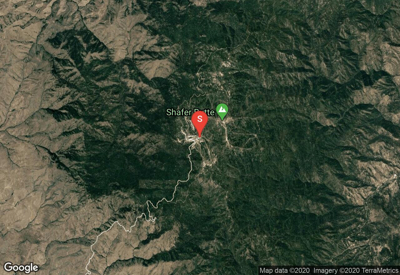
Idaho, Blaine County
02 :46 hrs
8.1 mi
261.1869 ft
Hard
Located at the Rotarun Ski Area, the route loops near Bullion Gulch and Democrat Gulch. This is a foothill area with mostly brush and shrubs. There are a lot of twists and turns, along with ups and downs. The route offers excellent views of Hailey, Della Mountain, Gillman Butte, and Kelly Mountain. Be sure to apply sunscreen and pack plenty of water.
Idaho, Boise
00 :42 hrs
2.2 mi
68.918945 ft
Moderate
Located in the lower foothills of Northwest Boise, the loops in this area are perfect for a quick run after work. The trails are all singletrack and built by volunteers of the Ridge to Rivers project. There are a few steep grades as the route traces along the ridge, and there are also great views of Boise.
Idaho, Lemhi County
07 :14 hrs
9.2 mi
446.31494 ft
Extreme
This run should only be attempted by those who are trained to do power running. The run follows the continental divide in a northwesterly direction near the Montana border. The trail is a singletrack with some strenuous grades, and it gets more difficult the farther north you go. It starts out fairly easy, so there is an option to plan a shorter out and back trip. There are some amazing views from the trail, a rock garden, and plenty of wildlife. If you plan on camping, a wilderness permit can be obtained from a Forest Service facility or a registration box.
Idaho, Boise
00 :39 hrs
2 mi
55.36743 ft
Easy
The route is perfect for runners that enjoy a quick, convenient exercise. At first, you will follow the Veterans Trail on doubletrack before it fades into a singletrack, and then you'll loop back with the Big Springs Trail. The route winds along ridges that offer views of the city and surrounding foothills. Be cautious of other users on mountain bikes.
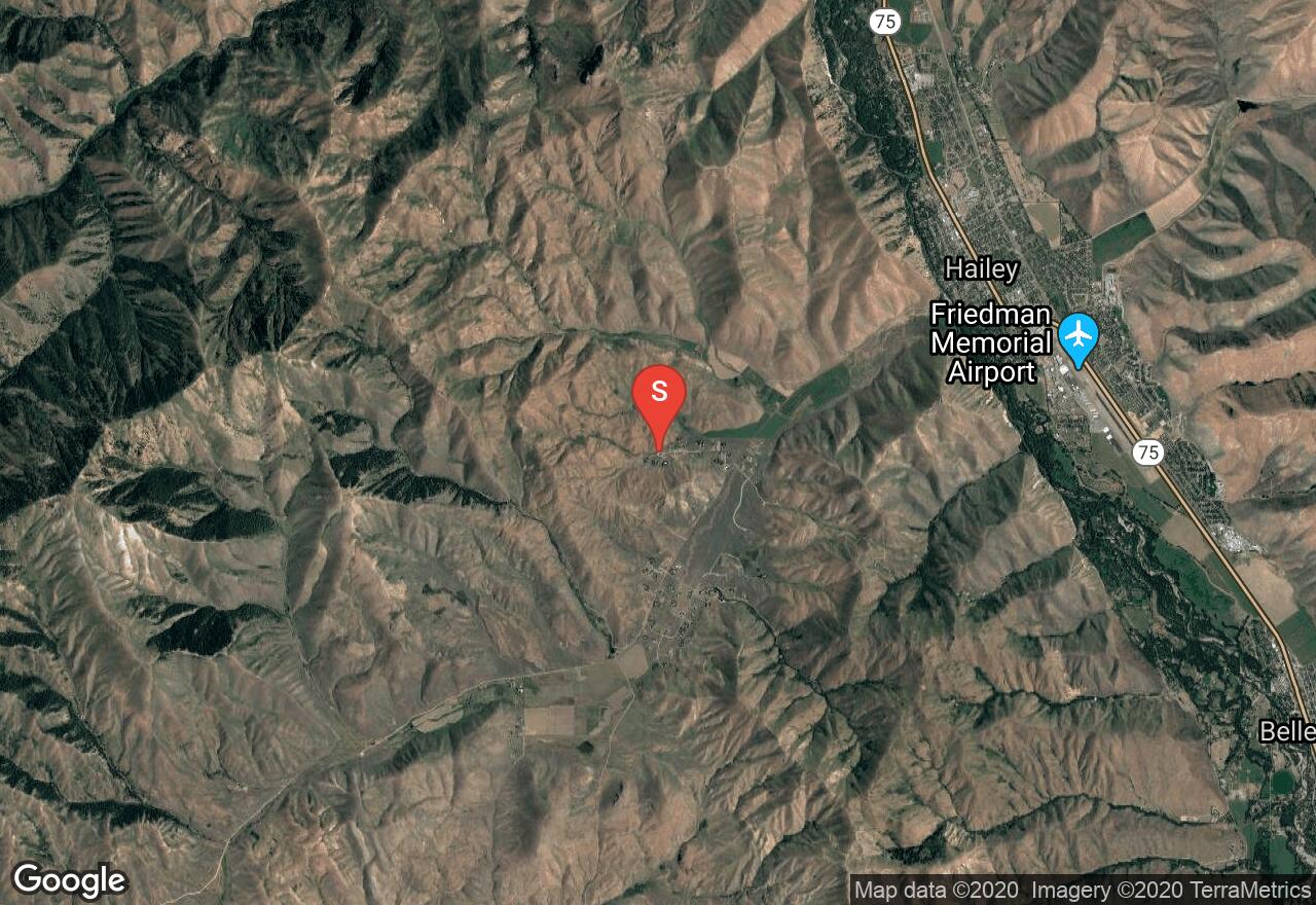
Idaho, Blaine County
01 :43 hrs
5 mi
153.94458 ft
Hard
The run is located outside of Hailey and up past Croy Willows Ranch. The route leads through shrubs and streamside vegetation, along with some areas of interesting rock formations. There is a small waterfall at Camp Creek, making it fun for the dogs to experience as well.
Idaho, Boise
01 :35 hrs
5 mi
125.90399 ft
Hard
The trail starts parallel to Mountain Cove Road at the Military Reserve Park. The route climbs gradually along Freestone Creek with eventual steep grades as it connects to other trails in the area. It's also a thrilling descent back to the trailhead. Be on the lookout for deer, coyotes, mice, fox, and hawks.
Idaho, Boise
01 :38 hrs
1.9 mi
303.20618 ft
Moderate
The route starts on the southern end of Lucky Peak Reservoir at the boat ramp. The area offers interesting rock formations as the route climbs gradually into the canyon. Enjoy some of the best views of the Boise River Valley with vistas across the Owyhees, along with views up the length of Lucky Peak Reservoir almost to Arrowrock Dam. Appropriate, sturdy footwear should be considered for the rocky hillsides.
Idaho, Teton County
04 :02 hrs
5.1 mi
272.99023 ft
Expert
This run takes you into the Big Hole Mountains on the western side of the Teton Valley. It starts with a challenging climb, and the run immediately goes with the Grandview Main dirt road through beautiful thick forest. Panoramic views of the Teton Mountain Range are absolutely amazing once you get up to the Packsaddle Lake Trail. From there, it's a short distance to the lake with a downhill grade.
Idaho, Cassia County
00 :47 hrs
2.2 mi
97.64111 ft
Moderate
The Eagle Interpretive Trail is located in the Sawtooth National Forest off of Rock Creek Road. The run loops around an area of thick forest with gentle grades. Watch out for birds and other wildlife, and be sure to take a jacket. The loop can be accessed from different campgrounds in the area, and it can also be navigated in either direction.
Idaho, Lemhi County
03 :54 hrs
5.2 mi
147.34644 ft
Expert
The trailhead is located south of the town Leadore, just past Leadore Hill. The Big Timber Creek area offers some pretty amazing trails. This route leads towards the Rocky Peak area, and it's only a section of large loop that goes around the mountain. The run leads through creeks, timber, shrubs, and loose rocks.
Washington, Pend Oreille County
03 :05 hrs
4.2 mi
98.38373 ft
Hard
This pleasant trail hugs the shoreline of Bead Lake as it travels through conifer forests whose moisture level varies based on the exposure of the slope (the north-facing slopes are quite lush, while the south-facing slopes are much drier.) All along the trail are good views of the lake's teal waters. The junction with the spur trail 127.1 is a good place to turn around, but it is also possible to continue on that trail or on the main trail to a remote upper trailhead (bridges on this trail have been known to wash out; check with the Newport Ranger Station for the latest information.)
Montana, Missoula
01 :42 hrs
5 mi
253.11475 ft
Moderate
Located in the foothills of Missoula, this trail is blooming with a variety of wildflowers in the summer. This route is easy to follow with a network of other trails as options to explore. The views of the valley are breathtaking.
Idaho, Boise
01 :35 hrs
5 mi
125.90399 ft
Hard
The trailhead is located off of Willow Creek Road in the Eagle Foothills. The route follows a two track dirt road through wildflowers around the seasonal Little Gulch. There are a lot of dips and climbs, so be prepared for a strenuous exercise and bring plenty of water. Be sure to contact the Ranch Manager with the number provided at the trailhead for permission to use the trail.
Idaho, Boise City
01 :40 hrs
2.1 mi
134.15741 ft
Moderate
The run starts at Hillside Jr. High School and leads into the Boise foothills. There are some strenuous grades, so be sure to pace yourself on the more level terrain and maintain your energy for the steeper sections. The route ends at Harrison Hollow Boulevard with the option of either running back, or finding a ride. Check online at (www.hillsidetothehollow.org) for up to date land management news.
Idaho, Madison County
00 :43 hrs
1.5 mi
126.10657 ft
Easy
A short nature hike on the outskirts of Idaho Falls that climbs through sagebrush-grass, juniper-covered slopes, and along a perennial creek. The trail offers a bit of history, wildlife, and open views of the Snake river, volcanoes, and farmland. The wildlife often sighted here could be rabbits, deer, small lizards, and possibly an eagle or a moose.
Idaho, Custer County
01 :02 hrs
2.6 mi
50.440186 ft
Moderate
Hike from campground to old mining cabin along Antelope Creek
Montana, Gallatin County
03 :43 hrs
3 mi
490.765 ft
Hard
This popular route is a favorite in the area. The trail travels through a dense evergreen forest alongside Cascade Creek. Enjoy the mini waterfalls on the journey up. This amazing lake was formed by a landslide damming the creek. It is nestled in a thick forest, surrounded by steep granite walls with views of the surrounding peaks. There are places to camp at the lake but there are no fires allowed within a half mile of the lake.
Idaho, Bonner County
01 :16 hrs
4.8 mi
87.63965 ft
Hard
This is a short but technical scenic tour at Lake Pend Oreille that has a lot of up and down on a smooth frequently-traveled singletrack trail. There are gorgeous views of the surrounding bays and mountains at the open areas of the trail. At Mineral Point, there is a rock monument dedicated to a Forest Service ranger that was killed while trying to stop a fugitive. Take a towel with you if you plan on taking a dip in the lake after the ride.
Idaho, Boise City
06 :18 hrs
4.9 mi
915.6188 ft
Expert
This is one the many different routes to reach Lucky Peak. The trail climbs up Shaw Mountain and reaches the southernmost flank of the Boise Front Range. Squaw Creek and Warm Springs Creek are located nearby and most of the vegetation will be in these these areas. There are remnants of over 9 mining sites on the mountains slopes, including a well preserved Adelmann Mine Group, complete with 2 standing structures. Each summer there is a songbird, raptor and owl survey that takes place on the summit of Lucky Peak because it lies within their migration paths.
Idaho, Blaine County
10 :35 hrs
18.7 mi
323.0498 ft
Moderate
The route extends from the SNRA (Sawtooth National Recreation Area) headquarters to Galena Lodge and can be accessed from many different points. Starting from the North Fork Campground, the ride follows the Big Wood River upstream. The route leads through spacious meadows, aspen stands, and lodgepole forests. There are also magnificent views of the surrounding Boulder Mountain Range and Smoky Mountains. During the winter months, the trail is groomed for cross country skiing. The ride can be either an uphill, downhill, or as an out and back adventure.
Montana, Missoula
05 :03 hrs
3.4 mi
751.70703 ft
Hard
Start gaining elevation immediately on this forested trail until you pass beyond timberline, where views of the Bitterroot Valley wait to meet you. Follow the ridge until the trail begins to switch back for the final stretch to the peak. Upon your arrival you will find a fire lookout shelter as well as inspiring views of the Bitterroot and Sapphire Mountain Ranges. This is a popular hike and you should plan on filtering or packing in your water. The peak is also a popular backcountry skiing destination with skiing on aspects from west to northeast. When travelling in the winter please be aware of current avalanche hazard and use safe travel protocol.
Montana, Ravalli County
03 :04 hrs
2.7 mi
351.2827 ft
Hard
Follow this wooded trail with frequent switchbacks until you reach the weather hardened canyon rim. The overlook offers a panorama of the Bear Creek drainage, surrounding peaks and glaciated terrain. This relatively short hike will provide a sample of the highly scenic Bitterroot Mountains.
Idaho, Blaine County
00 :36 hrs
2.3 mi
79.5271 ft
Hard
Mountain bike flow trail with jumps and berms.
Montana, Missoula County
02 :13 hrs
2.6 mi
108.66235 ft
Hard
Morrell Falls is a popular destination and is recognized as a National Recreation Trail. The trail travels through a thick mixed forest of pine, fir and spruce. There is great opportunity for viewing a variety of wildlife including: beaver, bobcat, bear, elk, deer, mountain lion and moose. These spectacular 90-foot double falls are quite a reward for such a short climb.
Montana, Lincoln County
04 :35 hrs
5.7 mi
199.34436 ft
Expert
This adventure can be done as a day hike or an overnighter. The trail is well maintained and extremely scenic. There is mild elevation gain, which makes this a great choice for all ages. Along the way is the spectacular Turner Falls. Shortly after the falls the trail turns into Fish Lake Canyon and features a string of mountain lakes.
Montana, Thompson Falls
00 :50 hrs
2.3 mi
31.233093 ft
Easy
This trail is a great family outing that makes two loops that are nearly flat. There is great opportunity for viewing wildlife, birds, wildflowers or just have a picnic along the resting benches. The trail is open during the winter for skiing and snowshoeing.
Montana, Ravalli County
02 :53 hrs
8 mi
38.940674 ft
Hard
This loop can be done in either direction but either way you do it will be spectacular. Forest surrounds you with views of Como Peaks. The trail is has very little elevation gain and is easy to follow. The south side receives a lot of traffic because it shares a route to other destinations and is a popular horse ride. The equestrians are not allowed on the north end.
Montana, Butte-Silver Bow (balance)
02 :41 hrs
5.6 mi
310.05408 ft
Hard
The trail to Beaver Ponds winds up the drainage by several old beaver ponds. This trail is easy to follow and well maintained by the Highlands Cycling Club. There are many options to add and make this a loop route for bikers.
Idaho, Valley County
05 :03 hrs
4.9 mi
275.21704 ft
Hard
This popular trail starts off of National Forest Road 698 near the Middle Fork Payette just south of Boiling Springs Campground. The route climbs into the North Fork Range through ponderosa pine and sub-alpine fir, offering excellent views of surrounding area. The Wild Idaho Endurance Runs use this trail as a part of their course.
Montana, Helena
03 :40 hrs
7.8 mi
451.62366 ft
Expert
This is a beautiful singletrack ride along Mount Helena ridge. Wildflowers are blooming in spring and there is lots of wildlife to be seen. The views of the valley and mountains are beautiful. The climbing is moderate and there are some nice downhill descents, with just a few spots that are technical.
Montana, Glacier County
04 :35 hrs
10.2 mi
508.66846 ft
Expert
Beautiful beautiful beautiful! The hike up is steep. The glacial carved valleys are stunning. It's great. We even jumped in the lake and stood on a chunk of floating ice!
Montana, Ravalli County
05 :21 hrs
6 mi
367.1548 ft
Expert
Blodgett Canyon has stunning 4000 ft. walls and has something for everyone to enjoy. The trail stays close to Blodgett Creek the entire time where some can enjoy fishing. Hikers can choose to travel 2 miles or continue to Blodgett Lake or High Lake (12.5 miles). This can be a great backpacking outing with lots of impressive scenery and wildlife. There are few waterfalls within the first 4 miles. The turnoff to High Lake Trail (left) is approximately 6 miles or you can continue up the canyon towards Blodget Lake and Blodget Pass.
Montana, Glacier County
00 :40 hrs
0.7 mi
57.947266 ft
Easy
St. Mary Falls is less than 2 miles roundtrip from the trailhead on the Going-to-the-Sun road just west of St. Mark Lake. This is a beautiful waterfall and worth spending some time for pictures. The colors in the later summer months can be gorgeous. This is more like a walk than a hike, you can also continue on one more mile to visit Virginia Falls.
Idaho, McCall
01 :40 hrs
6.1 mi
72.96387 ft
Hard
The Ponderosa Park Loop covers most of the peninsula at Payette Lake near McCall. Most of the riding along the park is level, except for the climb to Osprey Point. The ride goes through scenic, old ponderosa pine forest, with plenty of wildlife. The scenic overlook at Osprey Point offers a spectacular view of the lake. Canada geese, osprey, bald eagles, wood ducks, moose, beaver, muskrats, and songbirds can be observed in the area.
Idaho, Boise City
01 :51 hrs
7.4 mi
334.32336 ft
Hard
Also known as the Racetrack, this popular ride traverses the foothills of Boise that loops around the area offering views. There are a few shrubs in the area as the trail encounters Crane Creek, otherwise, it's a mostly well developed trail with a lot of ups and downs. This is an intermediate ride that offers a lot fun close to town.
Montana, Flathead County
02 :17 hrs
1.8 mi
225.13232 ft
Hard
Twin Lakes is located in the Jewel Basin. There are endless side trails and other destinations that can be reached from twin lakes. This area is popular and has special regulations to follow when exploring and camping. You can check the information at the trailhead or ranger cabin.
Idaho, Gem County
00 :13 hrs
0.5 mi
28.44104 ft
Easy
The Sagehen Nature Trail is an easy hike that goes along Sagehen Creek through Englemann spruce, grand fir, and lodgepole pine. It climbs to an area with boulders before looping back to the trailhead. The area is great for wildlife viewing while taking a break from recreating on the reservoir. Be on the look out for elk, deer, squirrels, and birds.
Idaho, Blaine County
01 :42 hrs
6.3 mi
186.51599 ft
Moderate
The Fox Creek Loop starts at the Lake Creek trailhead and immediately rides across a steel bridge into the Hulen Meadows. This is known as one of the more popular rides in the area, mainly because it doesn't ever get too steep and the downhill runs are perfect. The area offers wildflowers, aspen trees, nice views, and beautiful stream-side environment along the Big Wood River.
Idaho, Valley County
02 :32 hrs
4.5 mi
7.881592 ft
Moderate
Crown Point is a perfect family adventure that runs along a flat grade and follows the southeast shoreline of the Cascade Reservoir. The route is an old rail-trail that gets narrow and rough in some spots. The lake-side shorelines are a great area for a picnic if you have time. During hiking and biking season, the daytime temperatures can range from 55 - 80 degrees.
Idaho, Boise
01 :48 hrs
3.9 mi
302.8474 ft
Expert
The trailhead is located off of Forest Road 307 outside of town. The ride leads through an historic mining area with scenic views of pine forests surrounding Idaho City. The area offers a variety of riding surfaces and trails. The route can be used as a one way ride if you plan ahead and shuttle properly.
Idaho, Idaho County
01 :38 hrs
6 mi
97.41504 ft
Hard
This singletrack ride has smooth tread with a few bumps, rocks, and ruts. The ride goes along a rolling terrain through a shady forest of pines, firs and huckleberry bushes. The trail offers views of the Gospel Hump Wilderness and surrounding mountains. There are several small wooden bridges to cross, and gorgeous meadows to trace through. The route substitutes as a hiking and biking trail in the summer, and it is a nicely groomed cross country or snowshoe trail by winter.
Idaho, Bonner County
03 :57 hrs
7.6 mi
67.75159 ft
Hard
The route is a relatively flat trail that starts at Beaver Creek Campground. The ride leads through a beautiful old-growth cedar forest next to one of the states most treasured lakes. At first, it Immediately reaches Armstrong Meadows with some creek crossings. Most of the singletrack is smooth and buffed, with a few rooted and bogged areas. When the ride reaches Upper Priest Lake, there are beautiful views of the Selkirk Mountains. The route can be used as a one way, or as an out and back.
Idaho, Kootenai County
03 :37 hrs
14.3 mi
472.2025 ft
Hard
This is an awesome roller-coaster ride that has good climbs and fun, fast down hill runs. The trails are located on the north end of Coeur d'Alene and the ride starts off of Nettleton Gulch Road. The ride eventually reaches East Canfield Butte and West Canfield Butte, offering beautiful forest scenery and views of Lake Hayden. Be sure to wear a helmet, and use caution while riding the steep and rocky sections.
Idaho, Jefferson County
01 :29 hrs
3.2 mi
225.77112 ft
Moderate
Located in Southeastern Idaho, North Menan Butte is a short hike to one of the world's largest volcanic tuff cones. The trail loops around the cone's ridge and makes a pit stop at the R on the side of the Butte (for Rexburg). The cone rises to about 800 feet above the surrounding Snake River plain.
Montana, Ravalli County
06 :55 hrs
4 mi
1110.3287 ft
Expert
Rising 6000 feet above the Bitterroot Valley, Trapper Peak, at over 10,000 feet, is an impressive mountain. This destination is the high point of the Bitterroot Mountains, and with its high vantage and beautiful scenery, is one of the more popular peak hikes in the Bitterroots. Options for backcountry skiing abound, however, access to the high trailhead is closed in the winter months, adding some tedious length to the approach. The hike is fairly straightforward with only a short stretch of boulder hopping and class 2-3 scrambling towards the summit.
Montana, Ravalli County
08 :16 hrs
7.5 mi
937.35425 ft
Expert
This wilderness area hike offers nice views and a good option for an over night trip, although it is possible to make it a day trek. Good cutthroat fishing can be found at the lake while peak baggers and climbers will have plenty to occupy themselves using the lake as their bass camp. The surrounding peaks include Bass, St Joseph's and the locally named Stormy Joe Peak. There are several route options for summit attempts ranging from class 2 scrambling to class 5 climbing. A wolf pack has been known to reside in this drainage, although they prefer to remain elusive, you may be lucky enough to hear their song.
Idaho, Boise County
05 :01 hrs
4.4 mi
532.3574 ft
Expert
The hike to Sunset Mountain starts north of Idaho City near the Mores Creek summit in Boise county. Amazing all around views are applicable as you gain elevation up through the Boise National Forest. You will see the upper North Fork Boise River country and the Sawtooth Range from the top of the lookout. Because of how well developed the trail is, other types of adventurists enjoy this popular trail as well.
Idaho, Boundary County
03 :20 hrs
2.8 mi
467.036 ft
Hard
The Martin Creek trail has two trail-heads, consider to take the lower trail head as this is more accessible. The hike will follow an old widened forest road through old growth timber, new growth timber, cedar forests, ferns, and berry bushes. There aren't too many great views or overlooks on the trail but there is plenty of wilderness and different types of ecosystems to see. It is moderately used, so be on the look out for other adventurists on ATV's and motorbikes. There are parts of the trail that have loose gravel and slippery rocks from the creek so wear appropriate hiking shoes and maybe take an extra pair of socks.
Idaho, Bonner County
02 :17 hrs
2 mi
298.09546 ft
Moderate
Wylie Knob is a great hike that goes through a beautifully timbered cedar forest. The trail starts off wide and it will eventually become steeper as you go along. Some of the hillsides in this area show signs of erosion caused by rain and melting snow. The trail is moderately used by all types of adventurists and it also offers some amazing fall colors when in season. Deer, Elk and Moose thrive in this area so expect to see a lot of wildlife.
Idaho, Bannock County
01 :46 hrs
1.8 mi
155.28699 ft
Moderate
The Gibson Jack trail follows the creek of that name along a sage, buck-brush and juniper hill with scattered pines the first mile. It eventually reaches an area of aspen and heavier stands of pine with a mountain mahogany scene on the ridge. There are a few stream crossings and some with small wooden bridges. This is a very beautiful hike, especially when Autumn comes around. The route reaches the south and north forks of the creek that are stocked with Yellowstone cutthroat trout. Also, be on the lookout for mule deer.
Idaho, Coeur d'Alene
01 :03 hrs
2.4 mi
175.4411 ft
Moderate
Mineral Ridge is designated as a National Recreation Trail and also a great picnic site. The hike loops along a ridge that overlooks Coeur d'Alene Lake with amazing views of Beauty Bay, Wolf Lodge Bay, Beauty Creek Bay and the town. Old mine shafts can be located on the ridge where only hard rock mining occurred. Shrubs and ground cover plants such as forbs, grasses, moss and lichens make up the vegetation understory. The primary tree species you will notice are ponderosa pine and Douglas fir. The wildlife that most people intend to see in this area are deer, elk, and eagles.
Idaho, Bannock County
04 :19 hrs
3.4 mi
601.04175 ft
Hard
The trailhead and parking for Chinese Peak is just off of the Blackrock Road. At first, the route passes by a shooting range and then it's a gradual climb through the Blackrock Canyon. It does become more scenic but also more strenuous near the summit. There are amazing views of Pocatello and the surrounding mountains from the peak but it's also usually very windy. Be sure to be respectful to the property of the radio antennas and facilities at the summit.
Idaho, Owyhee County
04 :39 hrs
6.1 mi
93.048035 ft
Expert
Hardtrigger Falls is west of Bowmont in the Southwest Region of Idaho. The desert hike leads through the Owyhee uplands and canyons then traces along the Hardtrigger Creek. There can be some muddy creek crossings so be sure to wear appropriate footwear. Expect to see several wild horses and possibly some deer. You will also want to be well equipped with fresh water and snacks.
Montana, Madison County
02 :30 hrs
3.4 mi
23.51709 ft
Hard
It doesn't take long until the trail enters the deep canyon carved by the Madison River. This trail is mapped to turn around at the flat junction with Bear Trap Creek. Suitable camping exists at this junction and there are further options for exploring the canyon from this point.
Idaho, Latah County
02 :43 hrs
2.7 mi
156.69531 ft
Hard
The McCroskey Skyline Trail is part of a 5300-acre ridgeline park that is dedicated to pioneer women. The St. Joe area hike meanders thru a blend of trees in the Clearwater National Forest, including cedar and colorful decidious. The route follows a ridge line with expansive scenic views of the Palouse hills, Mineral Mountain, and the prairie. There are no entry fees to access the Mary Minerva McCroskey State Park.
Washington, Millwood
02 :20 hrs
5.3 mi
347.2672 ft
Hard
Antoine Peak is the highlight and highest point of the Antoine Peak Conservation Area east of Spokane. The park has a dense network of trails and jeep tracks open to mountain bikes, hikers, and equestrians (who always have the right-of-way.) The track shown here climbs Antoine Peak with the ascent at gentler grades than the descent, but there are dozens of possible approaches to the peak using trails of all difficulty levels. The hilly terrain around the peak is lightly forested with various pines and there are good views of Spokane, Mt Spokane, and the hills and valleys of the region.
Idaho, Adams County
02 :47 hrs
2.1 mi
381.6084 ft
Hard
Starting at the Deseret Cabin, the trail follows along the East Fork Weiser River and is a great way to travel from hot desert grasslands through cool conifer forests. The route connects with Idaho trail #213 and reaches Council Lookout. There are excellent views of the surrounding West Mountains with Council Mountain on the southern horizon. Mountain goat and deer inhabit the area.
Idaho, Idaho County
04 :58 hrs
3.3 mi
558.4961 ft
Hard
The trailhead is located at the Black Lake Campground off of Black Lake Road in the Seven Devils Mountains. The route follows along the Lake Fork Rapid River down through the canyon towards Lake Fork. The scenery is made up of pines, firs, larch, spruce and wildflowers. Also, wildlife in the area includes deer, elk, bighorn sheep, mountain goats, coyotes, and black bears.
Idaho, Idaho County
01 :32 hrs
2 mi
27.32129 ft
Moderate
Big Hazard is a really easy hike that starts at the Hazard Lake Campground near Hazard Lake in the Grass Mountains. The trail traces through the forest and meadows before reaching a large lake that is perfect for canoeing or floating. The still waters will offer beautiful reflections of the surrounding scenery.
Idaho, Washington County
04 :28 hrs
3.1 mi
725.5105 ft
Hard
Benton Creek is a tributary of the Sturgill Creek and the hike starts at the upper Benton Saddle trailhead. The trail meets with the Benton Creek and descends through the canyons of the Hitt Mountains before reaching a waterfall. The route experiences the melange and continental zone foothill ecological regions of Idaho. Ponderosa pine, Douglas-fir, and a variety of wildflowers make up the scenery here. The trail ends near Sturgill Creek and National Forest Rd 272.
Idaho, Idaho County
01 :57 hrs
4.8 mi
139.28027 ft
Hard
This is a great day hike in the Hazard Lake area that reaches Scribner Lake in a short amount of time. The trail traces through fir, wildflowers, meadows, and large boulders. There is a 400 foot granite overlook around the lake with pale cliffs, and brushes line up on the western end. The route also descends along Scribner Ridge in the Grass Mountains then climbs back up towards the trailhead.
Idaho, Sandpoint
03 :48 hrs
2.8 mi
623.69867 ft
Hard
The Mickinnick Trial-head is located near Sandpoint, Idaho on the inland maritime foothill of and valley. The name Mickinnick comes from the Kinnickinick plant that grows along the trial. When hiking up into the forested Selkirk Mountains, thimbleberries, ferns, mossy meadows and growth timber are expected along the way. There are switchbacks that go around huge rock outcroppings and some amazing views of Lake Pend Oreille, Sandpoint, and the Cabinet Mountains. Picnic benches are available for a healthy lunch break.
Idaho, Idaho County
01 :08 hrs
1.5 mi
53.321716 ft
Moderate
These springs are one of Idaho's most popular natural hot springs, and it consists of three different sources. They are located within the Clearwater National Forest and are accessed easily after a short hike from Highway 12. Soaking opportunities are available at the pools and the area is closed during the nighttime. Take the appropriate amount of food and water in regards to the amount of time that you plan on staying there.
Montana, Glacier County
07 :06 hrs
8.8 mi
91.37659 ft
Extreme
This is a long trail but very easy because of its little 300 ft. elevation gain. The trail is filled with ponds and flowers growing back since the 2006 burn. You will cross over Red Eagle Creek a few times on swinging bridges. Red Eagle Lake is also famous for its fishing.
Montana, Madison County
04 :08 hrs
3.3 mi
445.7849 ft
Hard
Louise Lake is a high alpine lake surrounded by 10,000-foot peaks. During heavy snow years the snowdrifts can still be on the trail through mid-July; and the lake may be frozen. This scenic hike is recognized as a National Recreation Trail for scenery. It can be a great choice for families because of the mild elevation gain. The lake has small cutthroat trout, but fishing is usually slow.
Montana, Madison County
04 :27 hrs
3.9 mi
459.09717 ft
Hard
During heavy snow years the snowdrifts may still be along the trail through mid-July. The trail has moderate elevation gain and offers beautiful scenery along the way. About half way up you pass through some beautiful meadows and small ponds. The lake is a clear emerald beauty surrounded by peaks that rise above 10,000 feet. Watch above on the cliffs for mountain goats. This trails offers a variety of recreation as it is also open to horse riding, and mountain biking.
Montana, Lewis and Clark County
03 :31 hrs
3.7 mi
132.90466 ft
Hard
This is a stunning canyon and scenic river that is a great family outing. The route has very little elevation gain and is an easy trail to follow. There is camping along the river and beyond Devils Glen. You can continue up the trail for a few miles or bushwhack north to the summit of Steamboat Mountain.
Montana, Mineral County
03 :11 hrs
3 mi
345.77246 ft
Hard
The route to Heart Lake follows a well maintained trail through lush green wilderness. It has mild elevation climb except a small hill right before the lake. The trail crosses the South Fork of Trout Creek a few times over bridges. At the last stream crossing before the lake is a sign pointing towards the lake. If hiking in the late summer or early Fall expect to enjoy some ripe huckleberries. If you want to continue on, Pearl Lake and Dalton Lake is another mile past Heart Lake.
Idaho, Idaho County
01 :40 hrs
1 mi
270.5681 ft
Moderate
Skookum Butte is a short hike with great reward full of panoramic views. A modified lookout still stands at the summit. The hike begins on an old jeep trail and then heads into heavy spruce and fir trees. If you are up for a longer adventure the trail continues on to Granite Lake.
Montana, Lake County
16 :45 hrs
15.3 mi
377.83276 ft
Extreme
The Swan Crest Trail runs the length of the northern Swan Range. The trail stays above 6,000 feet for almost the entire route. There is not any significant elevation change but the route is constantly climbing up and down. Passing by many destinations makes this a great route filled with variety and plenty of places to camp and explore.
Montana, Flathead County
01 :20 hrs
1.6 mi
78.404175 ft
Moderate
Howe Lake is one of the easiest hikes in Glacier National Park. There is limited parking at the trailhead. This trail can be extremely wet early in the season. Howe Lake is a beaver dam lake. Once you reach the lake you will see the beaver dam and the views open up to see the surrounding mountain ranges.
Montana, Missoula
00 :34 hrs
1.7 mi
2.1714478 ft
Easy
The Maclay Flat Nature Trail is a graveled path along the Bitterrot River with benches and informative signs along the way. In early spring the Bitterroot River sometimes overflows and temporarily submerges part of the trail. There is no drinking water access, so bring plenty. No bikes allowed and pets must be on leashes. Area closes from 10pm to 6am.
Montana, Missoula
01 :19 hrs
3.3 mi
141.86414 ft
Moderate
This trail is named after Missoula outdoorsmen. This trail travels through western larch and ponderosa pine. Watch for remnants of Missoula homesteads along the trail. Leave all artifacts alone as they are protected by law.
Montana, Missoula
01 :02 hrs
2 mi
66.00757 ft
Easy
This is one of Missoula’s best ski trails. The groomed route offers beautiful wintery scenery while traveling in the middle of the Sam Braxton National Recreation Trail. There are many cut-off routes to make this trip as long or short as you choose.
Montana, Bozeman
00 :40 hrs
0.7 mi
62.309204 ft
Easy
Don’t let the name scare you away. This short scenic hike is a great one for the family. With very little elevation gain this beautiful, forested lake is great for fishing, picnicking and relaxing. The trail continues on to the Garnet Mountain Lookout if you want a little longer adventure.
Montana, Missoula
01 :49 hrs
2.6 mi
9.188293 ft
Hard
The Kim Williams Nature Trail is a “Rails to Trails” project. Following an abandoned railroad with the Clark Fork River to the North this wide flat pathway has something for everyone to enjoy. There is a variety of wildlife to observe as well as plants and flowers.
Montana, Missoula
03 :08 hrs
2 mi
558.4001 ft
Hard
This beginning of this route follows the “M” Trail of steep switchbacks and then continues on for one more mile to Mount Sentinel. The view of the Bitterroot Mountains, Mount Jumbo and the Missoula Valley is exquisite from up top. This is a popular trail run for fitness buffs.
Montana, Missoula
01 :03 hrs
2.5 mi
135.18433 ft
Easy
The Sawmill Gulch area is giant network of trails. This is a nice easy loop that takes you through the Grant Creek area with fantastic views. There are many routes you can explore depending on your time and etc. Some of these trails were made by settlers and their livestock and others are from woodcutters salvaging timber. No dogs allowed in the are from Dec. 1st - May 15th.
Montana, Gallatin County
05 :08 hrs
5.8 mi
270.46863 ft
Expert
The South Cottonwood Creek Trail is well maintained and travels through dense old-growth forest and lush meadows filled with wildflowers. The trail crosses the creek over a bridge a few times and then ends at a Forest Service cabin. This is also a junction to the History Rock Trail which follows along Fox Creek. Because this trail is a nice gradual climb, you can of course choose a earlier turn back point for a shorter trip.
Idaho, Idaho County
00 :57 hrs
2.6 mi
51.120605 ft
Moderate
The Wilderness Gateway provides direct access to the wild and scenic Lochsa River as it loops around the campsite. The trail is located in a heavily forested area with an excellent opportunity for birdwatching. Elk, deer, moose, bears, cougars, and mountain goats make the steep canyon country their home.
Montana, Flathead County
01 :59 hrs
18.7 mi
83.00537 ft
Hard
The Great Northern Historical Trail is a popular rails-to-trails ride that begins near Kalispell Bay which is the largest natural freshwater lake west of the Continental Divide. Views of the surrounding mountains are endless as it travels on the outskirts of Kalispell. The route ends at Smith Lake Waterfowl Reserve. There are several stopping and starting points with parking along the way.
Montana, Gallatin County
01 :57 hrs
1.9 mi
185.41577 ft
Moderate
Black Butte Creek climbs up a forested drainage to a large open meadow at the base of King Butte. This is also the access trail to Big Horn Peak, King Butte, and Sheep Mountain. The trail is well maintained and traveled frequently.
Idaho, Midvale
08 :08 hrs
30.5 mi
134.39777 ft
Hard
Beginning in Midvale and descending the entire route along the Weiser River, this route follows a portion of the 84 mile Weiser River Trail. Accessible by only foot, bike or horse, this dirt road trail has various wildlife habitat, and land that is currently inaccessible to the public. Multiple bird species can be seen along the route including: Western Tanager, Northern Oriole, Lazuli Bunting, Spotted Towhee, Black-headed Grosbeak, and Great Blue Heron.
Montana, Lewis and Clark County
01 :26 hrs
3 mi
206.74512 ft
Hard
The ride through Trout Creek Canyon has incredible 1,000 ft. walls of limestone. The trail is the remains of an old road after a flood years ago in a narrow creek bed. It is mostly easy riding with some small sections of technical rough, rocky sections. There is great wildlife viewing opportunity.
Idaho, Bear Lake County
00 :54 hrs
1.3 mi
0.19958496 ft
Easy
The route is very short, and it's located in the Rainbow Unit of the Bear Lake National Refuge area. The route leads through marsh, sedges, grasses, and meadows. People come here especially for wonderful wildlife viewing. Calf moose, cranes, herons, egrets, and gulls are commonly sighted here. Snowshoeing and Cross-country skiing are allowed on every trail and road that allows hiking in the Refuge.
Idaho, Blaine County
01 :15 hrs
4.7 mi
137.64893 ft
Moderate
Fun loop connecting multiple trails.
Idaho, Blaine County
02 :20 hrs
8.9 mi
288.76294 ft
Moderate
A fun trail
Idaho, Latah County
02 :25 hrs
5.9 mi
252.76465 ft
Hard
The trailhead is located just north of Moscow and starts along the Foothill road. The hike climbs trough a partly wooded forest of Douglas Fir and some pines with a few switchbacks. There are few clearings away from the trees, and ponds can be spotted in areas where frogs are heard. The Headwaters trail was created as a result of an Eagle project by the scouts. Views of the surrounding Moscow Mountains and Palouse can be seen during this adventure as it loops back towards the trailhead.
Montana, Helena
00 :39 hrs
1.9 mi
284.2273 ft
Extreme
This route to Mount Helena is less technical than the others but it is still a steep and strenuous ride. The final stretch to the summit is the hardest part. This route is popular and crowded so watch out for hikers.
Montana, Flathead County
01 :44 hrs
1.9 mi
101.34851 ft
Moderate
The trail to Stanton Lake climbs gently through thick forest and is well maintained. Bugs can be a nuisance in the hot summer months so bring your repellent. There is often moose and beaver towards the head of the lake. This is bear country so be alert.
Idaho, Custer County
01 :59 hrs
1.8 mi
183.51294 ft
Easy
An easy hike with gradual incline. Trail is very well shaded. Abundant wildflowers.
Idaho, Bannock County
02 :53 hrs
6.3 mi
420.77722 ft
Hard
City Creek starts on the foothills of the Bannock Mountain Range on the outskirts of Pocatello. The hike traces up a ridge and offers great views of the city because of the few trees that are in the area. It then loops back down the mountain through shrubs and plants along the City Creek. Share the trail and yield to all mountain bikers and horseback riders. Also, be sure to stay on the trail and be respectful to private property.
Idaho, Boise City
00 :27 hrs
1.1 mi
42.6662 ft
Easy
Camel's Back is a great place for beginning hikers who are interested in a short walk and a quick exercise in Boise. The hike requires a gradual steep climb up a grassy hill located on the park's east side and loops back down the hill. Also, the route leads to the top of the hill's twin humps, which is why it gets its name. Atop the peak it offers excellent views of downtown Boise and the surrounding foothills.
Idaho, Boise City
01 :45 hrs
4 mi
266.4944 ft
Moderate
Table Rock & Quarry is a hike that leads out of the Treasure Valley and into the unwooded akaline foothills. The rock formations along the Quarry Trail are fascinating and you can sit on one of the smaller table rocks to enjoy the views of Boise. The trail winds its way under large sandstone blocks beneath the rim of Table Rock, and it makes for a great loop when combined with some of the other trails. You might run into some meadowlarks, swallows, rabbits, hawks, and rattlesnakes. Be well equipped with water and watch out for the cliff drop-offs.
Washington, Spokane
02 :58 hrs
7 mi
366.44873 ft
Hard
Liberty Lake Regional Park is a large forested area along Liberty Creek south of Liberty Lake near the Idaho border. There are a handful of trails that wind up the mountain slopes, but only one main loop consisting of the Liberty Creek Trail and the Edith Hansen Riding Trail. The trail climbs through dense, moist forest to the Cedar Grove Conservation Area, which is home to several impressive cedars at the upper end of the valley. The trail then climbs out of the valley to its western slope past several waterfalls before looping back across the marsh at the head of the lake to the trailhead.
Idaho, Ponderay
01 :04 hrs
1.6 mi
5.2074585 ft
Easy
This hike goes along the shore of Lake Pend Oreille and is easily accessed by the urban community of Sandpoint. The trail is great for all ages and it is not uncommon to see other people running, bicycling, or walking their dog here. There are some great views of the Cabinet Mountains from across the water.
Montana, Missoula
02 :00 hrs
7.7 mi
150.14392 ft
Moderate
Kreis Pond is a great place for recreating. There are campsites, picnic areas and fishing at the pond. There is no drinking water so be sure to bring plenty. This route is a mix of dirt roads and single track riding.
Montana, Gallatin County
02 :46 hrs
2.3 mi
362.35864 ft
Hard
The trail to Flathead Pass is a rocky mountain road with deep ruts and though it is possible to drive it with high clearance, the scenic area is better enjoyed on foot or by pedal. The forested path is surrounded by craggy outcroppings that make for a scenic journey. The destination is a vast meadow covered in wildflowers, if the time is right. Enjoy vistas of the Gallatin Valley to the west, Bridger Canyon to the east and mountains near and far surrounding you.
Montana, Lincoln County
03 :15 hrs
2.3 mi
477.9087 ft
Expert
Found in the remote Kootenai National Forest, this scenic destination will likely be yours to enjoy in solitude. At the peak you'll find an abandoned lookout shelter and on a clear day, views to the Canadian Rockies. The trail to Northwest Peak is well marked and easy to follow.
Montana, Big Sky
03 :06 hrs
3.5 mi
88.13562 ft
Hard
Porcupine Creek Trail follows the creek into the Porcupine Elk Preserve. This is obviously a great opportunity to see elk, deer, and coyotes too. The terrain is big open meadows and the trail crosses the creek a few times. You can extend the route further up the creek for two miles.
Montana, Cascade County
01 :08 hrs
5.7 mi
29.094116 ft
Easy
The River’s Edge Trail follows along the Missouri River and passes through several community parks. This is a great ride for families and younger children. It also passes by the Lewis and Clark Center which is a great place to stop and visit. There are picnic areas along the trail.
Idaho, Boundary County
00 :41 hrs
1.9 mi
35.089172 ft
Easy
This is a very short hike that starts from the Robinson Lake campground and follows along the Gill Creek. The trail will also loop around and go along the shore of the lake. There is a picnic area for a lovely lunch while you enjoy the scenery of the Cabinet-North Bitterroot Mountains. Blue Gill fish are present in the lake and there is an $8.00 day fee for site reservations.
Idaho, Boise
01 :20 hrs
5.6 mi
401.18713 ft
Hard
A short and convenient mountain bike trip that offers views of the city and Boise Mountains. The route loops along a dirt road through foothill shrub-lands and grasslands. At first, it climbs up towards Shaw Mountain Road, and then descends back to the trailhead.
Idaho, Boise County
04 :10 hrs
2.8 mi
662.22064 ft
Hard
The One Spoon trail is located in Valley County just south of Hard Scrabble Campground. The hike heads west from the Middle Fork of the Payette River with difficult, strenuous grades. This day hike gives an experience of unique granite formations, along with exceptional views of the surrounding North Fork Range, valleys, and creeks.
Oregon, Wallowa County
06 :41 hrs
5.2 mi
896.2379 ft
Moderate
This trail gradually ascends along the East Fork River south of Wallowa Lake. The trail starts at the south of Wallowa Lake State Park at a trailhead and follows through a dusty area towards the river. As it follows the river, pools form, meadows open up and there are many types of wildlife to enjoy. The trail eventually reaches Aneroid Lake, a pristine lake that provides perfect reflections of the Wallowa Mountains.
Montana, Ravalli County
04 :13 hrs
4.7 mi
279.89612 ft
Moderate
This hike is a good option for a snow free outing in the spring before other area trails open up. The trail consists mostly of forest service jeep road, brushing with private property as it follows the creek up. Please respect the rights of these land owners. The reservoir is surrounded by granite peaks and good camping can be found at the west shore, further up the drainage. These sights may serve as a base camp for travel to several high alpine lakes.
Idaho, Valley County
02 :58 hrs
2.7 mi
329.91577 ft
Hard
The trail starts off of Gold Fork Loop Road and it provides access to Needles Route. It's a gradual climb through the southern forested mountains of Idaho. There are water crossings with a small stream, and then with the North Fork Gold Fork River. The hike can be done as a quick day trip, or as a way to get to other trails in the area.
Montana, Gallatin County
02 :24 hrs
2.7 mi
136.51318 ft
Hard
Daly Creek is a beautiful hike crossing through rolling meadows and open hillsides. The climb is gradual and steady. This creek is the northernmost creek in Yellowstone. Once you reach the top, there is a junction to the cutoff trail to Tepee Creek to your west crossing over Daly Creek. This can be made a loop trip if you have access to a shuttle. The view of Crown Butte is the best part of this hike. This is a popular place for elk and other wildlife to roam.
Idaho, Adams County
01 :36 hrs
3.6 mi
196.9082 ft
Moderate
The trailhead is located off of Forest Road 079 in Adams County, and the hike is a short loop that navigates through the sub-alpine zone of Seven Devils Mountains. There are a few steep grades but most of the hike is downhill. Ant butte can be observed towards the northeast.
Idaho, Washington County
02 :24 hrs
2.6 mi
132.81934 ft
Hard
The hike starts off of Idaho Route 71 and climbs into the Cuddy Mountains through ponderosa pine and Douglas-fir. The trail reaches Brownlee Campground which is situated on deciduous vegetation and maple trees. This is the closest Forest Service Campground to Brownlee Reservoir. There are some historic sites located in the area, one of which is an old mining structure used for holding crude oil.
Idaho, Adams County
03 :37 hrs
3.6 mi
347.86414 ft
Hard
The trailhead is located off of Fall Creek Rd the West Mountains of Adams County. The route is well developed and traces through the Payette National Forest with a variety of vegetation and wildlife. Douglas-fir, ponderosa pine, grand fir, and western larch make up the forest along with a variety of wildflowers in the meadows. There are approximately 300 species of mammals and birds that inhabit the area.
Idaho, Boise
01 :18 hrs
1.4 mi
80.679565 ft
Moderate
The Hidden Springs trailhead is situated off of West Dry Creek road near the town of Eagle. The Hidden Springs area is known for its dedicated community space and access to the foothills. The foothills are an ever present backdrop for the community with electrifying sunrises and sunsets. The Hidden Springs trail is also known to be very pet and family friendly. There is a little bridge that crosses the creek and this offers a great place for kids to play and look for creatures.
Idaho, Latah County
04 :04 hrs
4.3 mi
317.3236 ft
Hard
The trail starts off of National Forest Road 370 near Prospect Peak, and is mostly ridge-line trail following an old access road. The hike traces through the Hoodoo mountains, and offers views of the surrounding Clearwater National Forest. This is a fairly easy day hike that ends at Road 770 near Gold Creek.
Idaho, Idaho County
05 :05 hrs
4.1 mi
739.30927 ft
Expert
The hike follows an old roadbed in Idaho County, and the lower part of the trail is fairly steep with loose rocks. The trail starts off of Highway 12 near Lochsa River and west of the Major Fenn Picnic Area. This is a very scenic area that offers a great outdoor experience in the Lochsa-Selway Clearwater Canyons. Be cautious of other adventurists as the trail is heavily used by mountain bikes and OHV's.
Idaho, Blaine County
01 :18 hrs
1.3 mi
101.016846 ft
Moderate
Located in Blaine County, the trail makes for a perfect day trip for beginning hikers. The route follows the Norton Creek uphill and ends up at the Norton Lakes Trailhead. From here you can choose to go back, or you can extend your adventure.
Idaho, Latah County
02 :29 hrs
2.2 mi
258.03333 ft
Moderate
The hike starts off of Strychnine Creek Road just north of the Strychnine Ridge in the Hoodoo Mountains. The trail is well maintained, making for a rather easy climb through the St. Joe Schist-Gneiss Zone. The route parallels with the Excavation Gulch at first, and then Strychnine Creek. Recent logging activity may result in occasional re-routing while hiking.
Washington, Clarkston
01 :10 hrs
5.9 mi
8.433548 ft
Easy
The Snake River Bikeway is a paved trail that runs along the western shore of the Snake River from Clarkston to Asotin. The level pathway is popular with all types of users and stays very close to the river beneath some impressive cliffs, including Swallow's Nest Rock, a basalt rock outcrop where nesting swallows can be found in the spring.
Idaho, Latah County
02 :56 hrs
2.8 mi
144.48474 ft
Hard
The Chesley Creek Trail starts off of Road 370, just east of Prospect Peak. The hike is a moderate to well maintained trail. And the route goes on a ridge between Big Creek and Meadow Creek. It has a history of being a good riding trial for horses, and it kind of has a rollercoaster effect with the grades involved with the terrain. Views of the surrounding Hoodoo Mountains can be observed from the few open spaces on the ridge. The trail will end at Road 1960 between Hope and Chesley Creeks.
Idaho, Idaho County
04 :36 hrs
3.6 mi
611.34436 ft
Hard
The trailhead is located off of Beaver Ridge Road 369 in Idaho County. The route starts along the Beaver Ridge Trail for a short distance, then junctions at Beaver Meadows. The trail presents a moderate hike over steep terrain in the Bitterroot Range, then descends through the Selway Bitterroot Wilderness ending at Storm Creek.
Idaho, Clearwater County
04 :57 hrs
4.8 mi
404.47314 ft
Expert
The hike begins at Road 547 and follows a flat ridgetop in the Clearwater Mountains. The trail presents a moderate hike through stands of old-growth fir in excess of 70" in diameter. At the lower end, the route passes through logged areas before reaching Sylvan Creek. Be well equipped with fresh water and snacks.
Idaho, Idaho County
04 :41 hrs
5.1 mi
236.85132 ft
Expert
The trailhead is located off of Road 523 near Chamook Saddle. The route gradually descends through the Clearwater Mountains, also provides access to Austin Ridge and Eldorado Creek. The southern end of the trail passes through clear-cuts, while trekking on portions of road. It ends at Eldorado Creek with an opportunity for a 17 mile loop.
Montana, Flathead County
00 :58 hrs
1.8 mi
6.2077637 ft
Easy
The Apgar bike trail travels from West Glacier to the Apgar Visitors Center. This paved route crawls through the woods and is mostly flat. It is a perfect route to enjoy with the family. Be cautious of the two road crossings along the way.
Montana, Glacier County
00 :39 hrs
0.9 mi
14.878906 ft
Easy
Rainbow Falls is a short scenic hike from the boat tour on Waterton Lake. This trail crawls through thick forests as you follow along the river. There is great opportunity for viewing wildlife. Also remember this is bear country so be prepared. Be sure to plan accordingly and give yourself enough time in order to catch your boat tour back.
Montana, Jefferson County
04 :43 hrs
3.1 mi
708.85095 ft
Hard
This popular trail is recognized as a National Recreation Trail. The first mile can be driven in a 4X4 vehicle. There are some steep parts on this hike. Haystack Mountain provides panoramic views of Boulder River Valley, and Elk Park. The trail is open to horses and mountain biking, so be alert along the trail.
Montana, Madison County
04 :16 hrs
3.1 mi
581.8661 ft
Hard
Curly Lake is a high pristine lake surrounded by 10,000-foot peaks. The trail has a very comfortable elevation climb and passes through scenic meadows of wildflowers and forested lodge pole pines. The route follows Curly Creek most of the way up into the basin. This trail is a popular mountain bike trail so be alert to possible riders.
Montana, Lincoln County
02 :42 hrs
2.5 mi
246.24548 ft
Hard
The first mile of this hike follows a road that is now closed to motorized vehicles for bear recovery. The trail is well maintained and stays mostly in the woods. At approximately 2 miles the trail will fork to the left and head down to the Lower Boulder Lake. The fork to the right leads to Purcell Marsh and Fish Lakes.
Washington, Pullman
01 :25 hrs
7.1 mi
48.69287 ft
Moderate
This paved trail connects the two college towns of Pullman, Washington and Moscow, Idaho. The trail follows an old railroad bed paralleling the main road between the towns and has great views of the rolling hills of the Palouse.
Idaho, Teton County
01 :24 hrs
1.7 mi
66.559204 ft
Moderate
Moose Creek starts off of Idaho State Highway 33 southeast of Victor. The hike follows along Moose Road and Creek through the partly forested Teton region. It will reach the Wyoming border along with the Moose Creek Recreation Site in a short amount of time.
Idaho, Valley County
00 :34 hrs
2.3 mi
175.9469 ft
Moderate
This is a downhill only ride and is part of the Jug Mountain Ranch Trails. Catch the shuttle to the top before your begin your descent. Expect a mixture of rocks, wood features, tables, and tacky berms. Shuttle is $20 for 3 hours of riding.
Idaho, Hayden Lake
01 :12 hrs
3.1 mi
31.119507 ft
Easy
Easy hike through a densely forested area. The easy to follow and maintained well. There is a nice little sitting area with a pond for resting or picnicking.
Montana, Lewis and Clark County
03 :51 hrs
4 mi
258.62268 ft
Hard
The trail to Heart Lake is wide and easy to follow. It is a popular one for horse packers and special regulations are to be followed while camping. While there are other lakes in the area Heart Lake is said to be the best. At about 3.9 miles watch for the trail junction and take the right fork.
Idaho, Shoshone County
04 :28 hrs
4.1 mi
365.6831 ft
Expert
Illinois Peak is just 7,690 feet but is one of the higher peaks in northeastern Montana. This area receives lots of snow and rain which makes the landscape extremely green and lush. The trail follows along the Stateline Trail. There is a great view of Oregon lakes about 1.5 miles up.
Montana, Gallatin County
05 :11 hrs
4.6 mi
535.6266 ft
Expert
The trail to Coffin Lakes starts out through a grassy, sagebrush country with the Lionhead Mountains in the background. At about 3 miles you reach a junction, take a right and the trail follows Coffin Creek through thick forests to the lake. Coffin Lakes offer good fishing and there are some campsites at the lower lake. It is a great base camp to explore other areas.
Idaho, Valley County
00 :40 hrs
2.7 mi
175.85803 ft
Moderate
Located in Jug Mountain Ranch, this adventure follows the DoeJoe Trail. You can catch a shuttle ride to the top for a downhill ride or begin riding from the bottom. Shuttle is $20 for 3 hours of riding.
Montana, Ravalli County
01 :00 hrs
2.5 mi
103.48303 ft
Moderate
This trail follows through the foothills with views of the Bitterroot Valley. Along the route are marked points that describe the benefits of wildfires, prescribed burns and restoring our forests after a burn. There is also a brochure with this information at the trailhead.
Montana, Ravalli County
00 :23 hrs
1.1 mi
20.437256 ft
Easy
These two short loops through the foothills are wide with a blanket of soft needles. There are pull-up bars and short hurdles on the fitness loop. The Nature loop is in the shade and has a self guided tour of vegetation along the way.
Montana, Flathead County
01 :22 hrs
1.5 mi
100.56311 ft
Moderate
Spotted Bear Lake is a seldom-used trail which has great views of the surrounding ranges. The trail continues on towards Spotted Bear Lookout if you’re up for a more strenuous adventure.
Montana, Flathead County
04 :33 hrs
5.8 mi
171.46655 ft
Hard
Bowman Lake is one mile wide and eight miles long. This peaceful lake is a place to get away from the crowds and enjoy some beautiful backcountry scenery. There is lots of wildlife and wildflowers to view along the trail.
Montana, Flathead County
05 :04 hrs
7 mi
33.64984 ft
Hard
Lake McDonald is the largest lake in Glacier National Park. It is a result of glacial carving and magnificent high peaks surround the lake. The trail has no elevation gain and is a beautiful way to spend a day.
Montana, Missoula
00 :38 hrs
1.6 mi
61.513916 ft
Easy
Hayes Point is a nice route to a rocky tree-covered overlook in the center of the Blue Mountain Recreation Area. From the point are fantastic views of the Bitterroot River and the surrounding mountains. The trail is open to ATV's and motorcycles.
Montana, Missoula
00 :52 hrs
2.3 mi
59.836 ft
Easy
This loop is an easy family outing. The trail is pretty much flat and there are many options of side trails and extensions to take. You can make this adventure as long or as short as you like. Bikes are only permitted on certain trails so check the regulations.
Montana, Missoula
00 :51 hrs
2 mi
115.655396 ft
Easy
The Blue Mountain Recreation Area has endless trails to explore. This route is an easy loop that can be extended in many directions. It is a perfect area for exploring and getting some exercise.
Montana, Missoula
02 :34 hrs
2.4 mi
291.49463 ft
Hard
This route leads to Curry Cabin and a few other log structures which were built in the late 1800s by Jacob Curry. The trail begins on the route to Stuart Peak and quickly cuts left into Curry Gulch. There are many side trails to explore to enjoy a different descent. No dogs allowed in the are from Dec. 1st - May 15th.
Washington, Pend Oreille County
00 :30 hrs
1.4 mi
16.5271 ft
Easy
This popular trail, which starts at a nice campground (with a small entrance fee,) loops around South Skookum Lake, providing good views of the lake and many opportunities for viewing wildlife. Parts of the trail are on wooden boardwalks and there are a few benches along the trail as well.
Montana, Missoula
03 :54 hrs
14.7 mi
324.4218 ft
Moderate
This is the longest loop of the bunch in this area. The route follows along dirt roads the entire way. Kreis Pond is a great place for recreating. There are campsites, picnic areas and fishing at the pond. There is no drinking water so be sure to bring plenty.
Montana, Missoula
01 :51 hrs
1.9 mi
71.71582 ft
Moderate
This route is a network of interconnecting trails that loop through sloping meadows and shady ponderosa pine forests. It is a groomed trail in the winter for cross-country skiing.
Montana, Missoula
00 :60 hrs
0.6 mi
179.92749 ft
Easy
The route to the “M” is a popular hike for families. This trail is short but steep. After a few switchbacks you will have a birds-eye view of the University and once up to the “M” the view of the city is nice. The trail does continue up to Mount Sentinel.
Montana, Missoula
02 :37 hrs
2.7 mi
234.31458 ft
Hard
This is one of the many routes that head to Mount Sentinel. The first section is steep but then one you get to the Fire Road the trail levels out and follows the contour of the mountain. The trail offers beautiful views of Mount Sentinel and the city. This area is popular for mountain bikes but they are prohibited on this trail.
Montana, Missoula
00 :41 hrs
2.6 mi
91.1698 ft
Moderate
Kreis Pond is a great place for recreating. There are campsites, picnic areas and fishing at the pond. There is no drinking water so be sure to bring plenty. This is the shorter loop of all the biking trails here.
Montana, Whitefish
00 :23 hrs
3.8 mi
13.749451 ft
Easy
This route is an easy stroll through the heart of Whitefish. It follows along the Whitefish River where there are resting and picnicking spots. Then loops through town and back to where you began. There is a short gravel section near the river.
Idaho, Boise City
02 :20 hrs
5.9 mi
209.88171 ft
Hard
Mountain Cove Loop starts near a military reserve park on the outskirts of Biose. This short and easy hike will take the adventurist through foothills, gully's, shrublands and brief encounters with the Cottonwood creek. This is a great place to exhort some energy while being away from the city. Preventing wildfires is important in this area because it can get pretty hot and dry during the summer months.
Washington, Newport
01 :41 hrs
3.4 mi
43.07965 ft
Moderate
The Wolf Donation Trails occupy a small parcel of the Colville (formerly Kaniksu) National Forest just north of Newport. The trails wind through dense evergreen forest past several overlooks of the Pend Oreille River. The trails east of the highway are generally steeper than those to the west.
Idaho, Twin Falls County
01 :46 hrs
4.3 mi
156.13782 ft
Moderate
A short hike in the Magic Valley region that starts off of Indians Springs road and loops around a high lava plateau. This is an extremely dry area with little vegetation and shrubs. Also, a great place to enjoy a beautiful sunrise or sunset. Take plenty of refreshing water for this adventure and be cautious of snakes.
Montana, Missoula
00 :40 hrs
1.3 mi
36.249634 ft
Moderate
This ride leaves from the heart of town and ends at the Rattlesnake National Recreation Area. It is a smooth singletrack that crawls through spotted pines as it follows along Rattlesnake Creek. A good ride for beginners with only a few little obstacles.
Idaho, Boise
00 :51 hrs
0.8 mi
70.21277 ft
Easy
Located in Elmore County, this is a very short hike that goes to a place called Neal Mine in the Southwest Region of Idaho. The route starts on a spur of the Little Fiddler and traces through the shrubland foothills. It ends up at an old mine where worn down concrete structures gives it an eery presence and ghostly feel. You are likely to run into different types of lizards and snakes in this area.
Montana, Lolo
03 :23 hrs
16.8 mi
43.82318 ft
Hard
This trail is paved and follows closely along Highway 93. There are several parking and pullout spots for fishing and picnicking access dispersed throughout the route. Enjoy the views of the Bitterroot Mountains to the west and the Sapphire Mountains to the east. Because it travels so closely to the highway the noise is a downside. The route stretches a total of 35 miles to Hamilton if you’re up for a long haul.
Idaho, Pocatello
00 :56 hrs
2.2 mi
61.029907 ft
Easy
The Red Hill trail is located on the outskirts of Pocatello in Bannock County. The hike goes up a little hill on the Upper Snake River Plain and the trailhead is on the side of Barton Road. The route goes along the ridge-line of Red Hill where there is a lot of sage and weeds. On the Summit, there is a weird concrete feature with 4 pillars along with views of the city. Some parts of the trail are paved at the bottom of the hill.
Washington, Pend Oreille County
02 :09 hrs
4.9 mi
32.78076 ft
Moderate
The Geophysical Sno-Park is named for the nearby national geophysical observatory. The trails traverse gently sloping land forested with pines and firs. The trails are machine groomed with tracks and skate lanes and range in difficulty from easiest to advanced. Snowshoeing, hiking, and dogs are not allowed on the groomed trails in the winter season. A Sno-Park pass is required to park at the trailhead.
Idaho, Fremont County
01 :51 hrs
4.5 mi
138.71313 ft
Easy
Loop from the upper road to the upper falls then down to the lower falls and back. Amazing waterfalls with great scenic views. Trail very easy and when it's summer you can drive almost right up to the upper falls.
Idaho, Owyhee County
01 :33 hrs
4.5 mi
25.790405 ft
Moderate
Halverson Lake is an easy hike that is perfect for beginners and located just outside of Boise. It's also great for anyone that enjoys archeological sites, birdwatching, and a desert lake. The trail starts at Celebration Park and loops through large boulders and wildflowers. Be sure to take pictures of the Indian petroglyphs and stone house ruins. Also, look for eagles and hawks in the cliffs of the canyon.
Montana, Flathead County
01 :59 hrs
2.3 mi
152.57458 ft
Moderate
One of the easier to reach Lakes makes this a popular one in Glacier National Park. During peak season expect an endless stream of people. Avalanche Lake attracts both hikers and anglers. Roughly one-half mile from the trailhead you’ll reach a footbridge that provides a spectacular view of the lower Avalanche Gorge, one of the highlights along the trail. Just past this point is the Avalanche Lake Trail junction. At the lake a steep-cliffed cirque tumbling with waterfalls sits the base of 8694 ft. Bearhat Mountain, which rises almost 4800 ft above the lake towards the northeast. For a little more solitude you can continue along the trail as it follows the west shore all the way to the head of the lake.
Idaho, Boise
02 :32 hrs
6.5 mi
231.67993 ft
Hard
Just minutes from of town this adventure winds up a canyon with a creek beside the trail most of the way. The access is great and the looped trail is well maintained. This day hike climbs up a gulch with sagebrush, wild plants, and it offers great views of Boise. Be cautious of mountain bikers interpreting along the trails in the area.
Washington, Spokane
00 :54 hrs
2.3 mi
82.53516 ft
Moderate
The McKenzie Conservation Area includes forested hills and open wetlands on the northwest shore of Newman Lake. The main trail leads south toward the lake along the edge of the wetlands and is a great place to see wildlife such as deer, moose, bald eagles, and turtles. A more challenging trail loops back to the parking area over a hill with a great view of Mt Spokane and the Spokane Valley.
Idaho, Bear Lake County
01 :47 hrs
3.6 mi
270.104 ft
Moderate
Located in Emigration Canyon, the Highline Trail is open to ATVs, snowmobiles, motorcycles, bikes, horses, and hikers. It is best known for its spectacular views of the Bear River range, and can be accessed by many other trails in the forest.
Oregon, Wallowa County
00 :49 hrs
1 mi
43.861572 ft
Easy
At the north end of Wallowa Lake lies beautiful meadows, the Iwetemlaykin (Nez Perce Indian tribe meaning "at the edge of the lake") State Heritage Site. The trail runs along Knights Pond, a local fishing spot, and through the meadows that fill with wildflowers in the spring and early summer. At the turnaround point of the trail is the Old Chief Joseph Gravesite.
Explore nearby adventures

