Best Climbing in Maryland
Trying to find the best climbing in Maryland? Bivy has great hiking, biking, paddling, climbing, skiing, riding and more, with hand-curated trail maps, as well as detailed driving directions.
Virginia, Fairfax County
00 :08 hrs
0.4 mi
16.753227 ft
Various
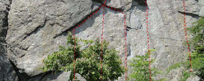
Located 14 miles from Washington D.C., Dihedrals Wall is one of many cliffs that sit along the Potomac River in Great Falls National Park. The rock is steep and drops straight into the river. With a variety of activities and the pleasant atmosphere, this area is a gem and very popular. Most of the climbing is toprope using trees for anchors. To approach the wall follow the trail and watch for the Mather Gorge plaque. Scramble down either side of the cliff to reach the bottom.
Maryland, Montgomery County
00 :02 hrs
0.1 mi
9.648067 ft
Various
Carderock is a cliff band that lies in a peaceful hardwood forest setting just outside of Washington D.C. along the east side of the Patomac River. The setting is beautiful and pleasant for climbing or just spectating. Routes are all toproped using tree anchors above the cliff line. To reach the base of the wall scramble down to the gully to the trail that skirts along the river. Nubble Face is located on the Hades Heights side downstream of the descent gully. You’ll find a good variety of difficulty levels. The river is directly behind the base of the cliff and very scenic.
West Virginia, Pendleton County
00 :17 hrs
0.5 mi
50.798553 ft
Various
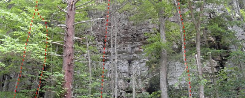
Seneca Rocks is a premier climbing area that is rich with history and best known for incredible multi-pitch trad routes that offer an old-school climbing feel. It is impressive, but intimidating and requires confident gear placement. The approach is steep and exposed- with some routes that require climbing a 5.2-5.5 to reach. The rock can be loose so be sure to bring your helmet. Camping, gear and guides are available at Seneca Shadows Campground or Yokum’s in town. Ecstasy Buttress is the first buttress of rock after crossing the river. The trail splits and the Ecstasy routes are to the right (south end of cliff).
Virginia, Fairfax County
00 :15 hrs
0.6 mi
13.127983 ft
Various
Located 14 miles from Washington D.C., Romeo’s Ladder is one of the many cliffs that sit along the Potomac River in Great Falls National Park. The rock is steep and drops straight into the river. With a variety of activities and the pleasant atmosphere, this area is a gem and very popular. Most of the climbing is toprope using trees for anchors. Romeo’s Lader has some good routes that are anchored by trees. To access the base, rap from the trees up top or scramble down climbers left side to reach the bottom of the routes. Romeo’s Ladder is the classic here.
West Virginia, Pendleton County
00 :00 hrs
- mi
- ft
Various
Located 1 mile east of the small charming town of Franklin, Parking Lot Wall offers unique and rare limestone climbing in the east. With a collection of sport routes this wall is a car-to-crag approach. The area is on private property so be respectful. Leave your dogs at home and camping is not allowed at the wall- but available nearby.
West Virginia, Pendleton County
00 :13 hrs
0.2 mi
61.619995 ft
Unknown
Located 1 mile east of the small charming town of Franklin, this area offers unique and rare limestone climbing in the east. Impact Zone is located past the Parking Lot Wall and Contact Zone. It offers several moderate routes with a few classics. This area is on private property so be respectful. Leave your dogs at home and camping is not allowed at the wall but available nearby.
West Virginia, Pendleton County
00 :29 hrs
0.6 mi
130.50214 ft
Various
Seneca Rocks is a premier climbing area that is rich with history and best known for the incredible multi-pitch trad routes that offer an old-school climbing feel. It is impressive, but intimidating and requires confident gear placement. The approach is steep and exposed- with some routes that require climbing a 5.2-5.5 to reach. The rock can be loose so be sure to bring your helmet. Camping, gear and guides are available at Seneca Shadows Campground or Yokum’s in town. The South Peak holds several classics and sees the most traffic. Climb the steep stairs known as the stairmaster. Follow the talus field where things become exposed. Access Triple S from Luncheon Ledge.
Virginia, Fairfax County
00 :20 hrs
0.8 mi
15.951818 ft
Various
Located 14 miles from Washington D.C., Bird’s Nest is one of the many cliffs that sit along the Potomac River in Great Falls National Park. The rock is steep and drops straight into the river. With a variety of activities and the pleasant atmosphere, this area is a gem and very popular. Most of the climbing is toprope, using trees for anchors. Bird’s Nest is one of the better walls at Great Falls and features routes geared towards the more experienced climber. The cliff has over 10 routes averaging about 50-60ft. tall. Z-Slash and Two-Lane Highway are the must do routes.
West Virginia, Pendleton County
00 :06 hrs
0.1 mi
24.135925 ft
Various
Located 1 mile east of the small charming town of Franklin, this area offers unique and rare limestone climbing in the east. Contact Zone is found just up the trail from the Parking Lot Wall and a good variety of moderate sport routes. This area is on private property so be respectful. Leave your dogs at home and camping is not allowed at the wall but available nearby.
Maryland, Montgomery County
00 :03 hrs
0.1 mi
11.334955 ft
Various
Carderock is a cliff band that lies in a peaceful hardwood forest setting just outside of Washington D.C. along the east side of the Patomac River. The setting is beautiful and pleasant for climbing or just spectating. Routes are all toproped using tree anchors above the cliff line. To reach the base of the wall scramble down to the gully to the trail that skirts along the river. Elsie’s Area is the next formation downstream from Jane’s Face. There are a few challenging routes and the classic Sterling’s Crack.
Maryland, Frederick County
00 :16 hrs
0.2 mi
82.760376 ft
Various
Sugarloaf Mountain is nestled in a beautiful recreation area that is privately owned. You will find the scenery and approach trail are worth the drive alone. The gate opens at 8:00am and locks at dark so be sure to plan your day accordingly. There is no fee required but donations are welcome. During popular climbing season it can get crowded so don't plan on having the place to yourself. The rock quality is good here and consists of sharp, white quartzite. You'll find a variety of terrain and features. During the popular climbing season it can be crowded.Boy Scout Ledges is just beyond and across The Pillar on the left as you climb to the summit of Sugarloaf Mountain. The wall is packed with vertical and horizontal cracks. Most of these routes are top rope only but a few do take gear. This area is a nesting site for ravens. The landowners ask that climbers avoid the climbs/areas where ravens are nesting. The nesting period generally lasts from mid May to late June/early July. During this time, observe any closure signs.
Maryland, Harford County
00 :15 hrs
0.2 mi
76.64301 ft
Various
Located 40 minutes from Baltimore, Rocks State Park offers quality trad and toprope routes in a scenic forested setting. The rock is hard and can eat up stopper placements. There is some fixed gear, but new fixed gear is banned. The prime time for climbing is late fall but winter climbing is possible because of the south-facing walls. Be aware of copperhead snakes as you hike the purple-blazed approach trail. Biceps Wall is located on the south side of the main rock formation. You’ll find some good toprope routes and a few that take pro. “The Crux” is a popular lead route.
Maryland, Montgomery County
00 :03 hrs
0.1 mi
10.669834 ft
Various
Carderock is a cliff band that lies in a peaceful hardwood forest setting just outside of Washington D.C. along the east side of the Patomac River. The setting is beautiful and pleasant for spectators. Routes are all toproped from tree anchors above the cliff line. To reach the base of the wall scramble down to the gully to the trail that skirts along the river. Herbie's Area is the furthest section of rock upstream. There are a few good routes and the historical Herbie's Horror
Virginia, Fairfax County
00 :15 hrs
0.6 mi
13.472904 ft
Various
Located 14 miles from Washington D.C., Seclusion is one of the many cliffs that sit along the Potomac River in Great Falls National Park. The rock is steep and drops straight into the river. With a variety of activities and the pleasant atmosphere, this area is a gem and very popular. Most of the climbing is toprope, using trees for anchors. Seclusion offers some fun routes that are on the easier scale. Climbs range from 35 to 45 feet. To access the base, rap from the trees up top or scramble down the class 5 gully between Romeo’s Ladder and Seclusion.
Maryland, Montgomery County
00 :02 hrs
0.1 mi
11.259054 ft
Various
Carderock is a cliff band that lies in a peaceful hardwood forest setting just outside of Washington D.C. along the east side of the Patomac River. The setting is beautiful and pleasant for climbing or just spectating. Routes are all toproped using tree anchors above the cliff line. To reach the base of the wall scramble down to the gully to the trail that skirts along the river. Beginners Crack section is the first rock formation found upstream from the descent gully on the Jungle Cliff side. You will find a collection of beginner routes with the classic Beginner’s Crack route.
Virginia, Rockingham County
00 :04 hrs
0.1 mi
20.928345 ft
Various
Located in Rawley Springs, Lovers’ Wall is a short cliffband that offers a selection of boulder problems. From the parking area follow a short trail up the hillside to the base of the cliffband. All routes average about15ft. high. Bring a spotter.
Maryland, Montgomery County
00 :03 hrs
0.1 mi
11.706734 ft
Various
Carderock is a cliff band that lies in a peaceful hardwood forest setting just outside of Washington D.C. along the east side of the Patomac River. The setting is beautiful and pleasant for climbing or just spectating. Routes are all toproped using tree anchors above the cliff line. To reach the base of the wall scramble down to the gully to the trail that skirts along the river. Jane’s Face Area is the furthest section of rock upstream. It holds some quality beginner routes and is popular. To access the top for anchor setup, continue upstream to a ramp that will get you to the top of the formation.
Virginia, Rockingham County
00 :04 hrs
0.1 mi
20.928345 ft
Unknown
Located in Rawley Springs, Juliet’s Tower is a steep block with clean, quality routes. The best climbing in this area is on the tower. It is about 25ft. high so consider bringing a short rope for a toprope. From the parking area follow a short trail up the hillside to the base of Lovers’ Wall. Juliet’s Tower is near the end of the cliff band.
Maryland, Harford County
00 :09 hrs
0.1 mi
46.070305 ft
Various
Located 40 minutes from Baltimore, Rocks State Park offers quality trad and toprope routes in a scenic forested setting. The rock is hard and can eat up stopper placements. There is some fixed gear, but new fixed gear is banned. The prime time for climbing is late fall but winter climbing is possible because of the south-facing walls. Be aware of copperhead snakes as you hike the purple-blazed approach trail. Moby Dick Boulder is located right along the trail about halfway up to the main routes. It is a unique and impressive boulder with two problems.
Maryland, Harford County
00 :14 hrs
0.3 mi
75.09844 ft
Various
Located 40 minutes from Baltimore, Rocks State Park offers quality trad and toprope routes in a scenic forested setting. The rock is hard and can eat up stopper placements. There is some fixed gear, but new fixed gear is banned. The prime time for climbing is late fall but winter climbing is possible because of the south-facing walls. Be aware of copperhead snakes as you hike the purple-blazed approach trail. Strawberry Jam Pillar is a detached spire that sits on the south end of King and Queen’s seat. You’ll find some of the most popular routes and topropes that are easily setup from bolts on top of the pillar. The Northface routes are a bit longer reaching 45ft.
Maryland, Montgomery County
00 :03 hrs
0.1 mi
11.620743 ft
Various
Carderock is a cliff band that lies in a peaceful hardwood forest setting just outside of Washington D.C. along the east side of the Patomac River. The setting is beautiful and pleasant for climbing or just spectating. Routes are all toproped using tree anchors above the cliff line. To reach the base of the wall scramble down to the gully to the trail that skirts along the river. Easy Layback Area is the furthest section of rock downstream in the Hades Heights Area. There is a good range of difficulty and a few classics.
Maryland, Montgomery County
00 :03 hrs
0.1 mi
12.830267 ft
Various
Carderock is a cliff band that lies in a peaceful hardwood forest setting just outside of Washington D.C. along the east side of the Patomac River. The setting is beautiful and pleasant for climbing or just spectating. Routes are all toproped using tree anchors above the cliff line. To reach the base of the wall scramble down to the gully to the trail that skirts along the river. Cripple’s Crack Area is located on the Hades Heights section downstream from the descent gully. It is next to Nubble Face and offers some challenging routes.
Maryland, Frederick County
00 :11 hrs
0.2 mi
49.768524 ft
Various
Sugarloaf Mountain is nestled in a beautiful recreation area that is privately owned. You will find the scenery and approach trail are worth the drive alone. The gate opens at 8:00am and locks at dark so be sure to plan your day accordingly. There is no fee required but donations are welcome. During popular climbing season it can get crowded so don't plan on having the place to yourself. The rock quality is good here and consists of sharp, white quartzite. You'll find a variety of terrain and features. During the popular climbing season it can be crowded. Middle Earth is off to the right along the main trail about 5 minutes. This area is a nesting site for ravens. The landowners ask that climbers avoid the climbs/areas where ravens are nesting. The nesting period generally lasts from mid May to late June/early July. During this time, observe any closure signs.
Maryland, Frederick County
00 :13 hrs
0.2 mi
67.734406 ft
Various
Sugarloaf Mountain is nestled in a beautiful recreation area that is privately owned. You will find the scenery and approach trail are worth the drive alone. The gate opens at 8:00am and locks at dark so be sure to plan your day accordingly. There is no fee required but donations are welcome. During popular climbing season it can get crowded so don't plan on having the place to yourself. The rock quality is good here and consists of sharp, white quartzite. You'll find a variety of terrain and features. During the popular climbing season it can be crowded. The Pillar is a few minutes past Middle Earth along the main trail. Look for a large pebbly boulder on the right next to some stairs. There is a few short boulder problems that can be toproped. This area is a nesting site for ravens. The landowners ask that climbers avoid the climbs/areas where ravens are nesting. The nesting period generally lasts from mid May to late June/early July. During this time, observe any closure signs.
West Virginia, Pendleton County
00 :24 hrs
0.5 mi
90.19806 ft
Various
Seneca Rocks is a premier climbing area that is rich with history and best known for incredible multi-pitch trad routes that offer an old-school climbing feel. It is impressive, but intimidating and requires confident gear placement. The approach is steep and exposed- with some routes that require climbing a 5.2-5.5 to reach. The rock can be loose so be sure to bring your helmet. Camping, gear and guides are available at Seneca Shadows Campground or Yokum’s in town. Southern Pillar is located to the right off Roy Gap Road, while all other walls/routes are on the main cliff to the left. Look for a large boulder with a plaque and follow the short trail on the right to the base of the pillar. The rock is similar to the rest of Seneca and you will find a few classics that are worth doing. It gets shade till early afternoon.
Maryland, Montgomery County
00 :02 hrs
0.1 mi
10.0738945 ft
Various
Carderock is a cliff band that lies in a peaceful hardwood forest setting just outside of Washington D.C. along the east side of the Patomac River. The setting is beautiful and pleasant for climbing or just spectating. Routes are all toproped using tree anchors above the cliff line. To reach the base of the wall scramble down to the gully to the trail that skirts along the river. Desperation Area is the rock formation on your left as your descend down the gully. There are a few routes worth doing.
Virginia, Shenandoah County
00 :05 hrs
0.2 mi
3.43219 ft
Various
Located in the Elizabeth Furnace area, Talking Headwall offers a roadside crag with big overhangs on friendly jugs. From the parking, hike back north along the narrow road to a trail to the left. You’ll find a collection of moderate routes. The cliff sees early morning sun and is shaded for the rest of the day. Toprope access is a short hike around the right side of the cliff.
Virginia, Fairfax County
00 :14 hrs
0.6 mi
13.654026 ft
Various
Located 14 miles from Washington D.C., Juliets Balcony is one of the many cliffs that sit along the Potomac River in Great Falls National Park. The rock is steep and drops straight into the river. With a variety of activities and the pleasant atmosphere, this area is a gem and very popular. Most of the climbing is toprope using trees for anchors. Juliets Balcony is downstream from Dihedrals and is recognized by the prominent ledge at mid-cliff, with a few routes that begin from there. To reach the base of the wall, scramble down a 4th-class break or rappel.
Maryland, Montgomery County
00 :03 hrs
0.1 mi
10.669834 ft
Various
Carderock is a cliff band that lies in a peaceful hardwood forest setting just outside of Washington D.C. along the east side of the Patomac River. The setting is beautiful and pleasant for climbing or just spectating. Routes are all toproped using tree anchors above the cliff line. To reach the base of the wall scramble down to the gully to the trail that skirts along the river. Barnacle Face is located on the Jungle Cliffs side just right of Elsie’s Area. It is recognized by the inverted V shape overhang. There are 2 quality routes here.
Maryland, Montgomery County
00 :07 hrs
0.3 mi
13.713242 ft
Unknown
Angler’s Inn is located in Great Falls, Maryland and is a short walk down the towpath. Park across the street from Angler’s Inn and cross the footbridge over the canal. It is the first rock outcrop on the left side of the towpath. There is just 2 climbs and you must rappel down to access the base of the cliff.
Virginia, Rockingham County
00 :04 hrs
0.1 mi
17.978271 ft
Unknown
Located in Rawley Springs, Ice Cube is a short boulder adjacent to Juliet’s Tower. From the parking area follow a short trail up the hillside to the base of Lovers’ Wall. There is one short problem.
Maryland, Harford County
00 :14 hrs
0.3 mi
75.09844 ft
Unknown
Located 40 minutes from Baltimore, Rocks State Park offers quality trad and toprope routes in a scenic forested setting. The rock is hard and can eat up stopper placements. There is some fixed gear, but new fixed gear is banned. The prime time for climbing is late fall but winter climbing is possible because of the south-facing walls. Be aware of copperhead snakes as you hike the approach trail. King and Queen Seats are the prominent detached boulders located north of the pillar. Some brave folks climb as a boulder problem and some rope up. There is a pine tree on top that can be used as an anchor if you want to rope up.
Explore nearby adventures

