Best Snowshoeing in Rocky Mountain National Park
Trying to find the best snowshoeing in Rocky Mountain National Park ? Bivy has great hiking, biking, paddling, climbing, skiing, riding and more, with hand-curated trail maps, as well as detailed driving directions.
Colorado, Larimer County
03 :20 hrs
1.6 mi
238.4668 ft
Moderate
The Lake of Many Rocks is a short but spectacular hike in the busy Bear Lake area of RMNP. It's a little more strenuous than the more popular lakes, so you may be the only person there if it's "off season." There are incredible views along the way and the multitude of large rocks leading up to the lake provides for an excellent foreground in photos. It's one of John Fielder's favorite in RMNP. There's some slight avalanche danger as you climb the last hill to the lake
Colorado, Larimer County
03 :33 hrs
2.1 mi
198.1206 ft
Hard
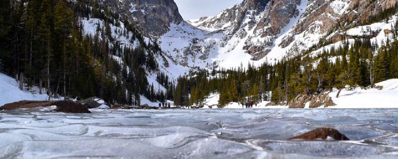
Located in the Rocky Mountain National Park this route begins at Bear Lake. It wraps around Bear Lake and continues with a moderate but steady ascent to Nymph Lake, Dream Lake and then ends at Emerald Lake. Fishing is popular in Emerald Lake but is not allowed in Bear Lake. If Dream Lake is frozen solid you can snowshoe across.

Colorado, Larimer County
00 :26 hrs
0.7 mi
14.467041 ft
Easy
The Bear Lake Trail is located in the Rocky Mountain National Park. The route is short with little elevation gain. The views are pristine during the winter. This is an excellent choice for families or beginners.

Colorado, Larimer County
01 :55 hrs
1.6 mi
204.92651 ft
Moderate
Situated in Rocky Mountain National Park, Emerald Lake lies in a glacially carved valley east of Hallett Peak. This short and popular hike offers incredible mountain scenery with relative ease. The trail gently ascends through a forest of lodgepole pines, Engelmann spruce, and subalpine fir to Nymph Lake. Beyond the small lake the trail climbs out of the thick forest and into a more exposed terrain as it skirts the edges of Dream Lake and continues on to Emerald Lake.

Colorado, Larimer County
02 :39 hrs
2.3 mi
443.0105 ft
Moderate
This is a fairly strenuous hike up the Long's Peak trail to the junction of Chasm Lake. It begins in the beautiful alpine forest and has spectacular views the entire way.

Colorado, Larimer County
00 :34 hrs
2.1 mi
463.3318 ft
Hard
This is a strenuous hike up the historic Flat Top Mountain Trail. Is trail was used by Arapaho Indians before Europeans arrived. It was also the site of a major battle between Arapaho and Apache, with the Arapaho pushing the Apache up over the Continental Divide. This trail continues to the top of the divide, but it was too windy above tree line to continue this day. This trail starts at Bear Lake but I forgot to track it from the beginning, so it starts where I stopped.
Colorado, Larimer County
05 :51 hrs
4.1 mi
409.4485 ft
Hard
Located in Rocky Mountain National Park, the Gash is the wide open area of the valley at the base of Andrews Tarn, where the retreating Andrews Glacier left debris. The trail continues up to the glacier, but with breaking trail in 2-3 ft of new snow we couldn't get any farther. This hike requires more effort that the neighboring Sky Pond/Lake of Glass route, but it's worth the effort. You'll enjoy views of Andrews Glacier, Andrews Tarn, and The Sharkstooth once you get past The Gash.
Colorado, Larimer County
04 :08 hrs
4 mi
344.80908 ft
Moderate
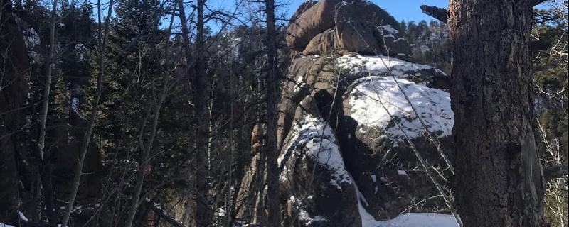
If you want to get away from the crowd at Gem Lake consider continuing your journey out to Balanced Rock. This entire area of RMNP is known for its climbing routes and interesting rock formations. The trail is well maintained and you'll have views toward the Mummy Range. You'll spend most of your time below tree line, and walking among numerous species of trees.

Colorado, Larimer County
02 :27 hrs
5.7 mi
186.45361 ft
Hard
The hike to Cub Lake crosses a creek and heads into Moraine Park where the most beautiful wildflower displays are found within Rocky Mountain National Park. It winds through open meadows to Cub Lake where it then enters a thick forest of evergreens on its way toward Fern Lake Trail. It follows the creek as the trail weaves in and out of the forest back to a dirt road leading to the parking lot.

Colorado, Larimer County
00 :18 hrs
0.8 mi
4.216797 ft
Easy
This short and easy hike loops around Sprague Lake through open meadows on the outskirts of the lake and through bordering evergreen forests. On this trail, you'll find view of Otis Peak, Hallett Peak, and Flattop Mountain which are all part of the Colorado Front Range.
See more adventures..
Explore complete list
Explore nearby adventures

