Best Trails in Arkansas
Trying to find the best trails in Arkansas? Bivy has great hiking, biking, paddling, climbing, skiing, riding and more, with hand-curated trail maps, as well as detailed driving directions.
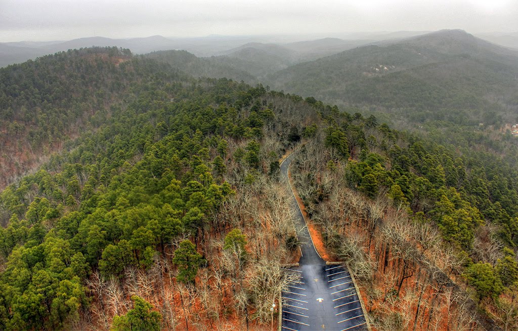
Arkansas, Washington County
00 :24 hrs
1 mi
27.710846 ft
Moderate
This trail takes you past historic homes and ruins along with amazing rock facings. You mass the major Earle ruins and get an amazing look out view of the Cane Hill College. You will need a good pair of hiking shoes for this trail.
Arkansas, Logan County
03 :03 hrs
9.3 mi
499.44263 ft
Hard
This hike begins near the highest point in Arkansas atop Mount Magazine. You’ll follow the trail down past the bluffs ringing the mountaintop and descend fifteen hundred feet through dense hardwood and evergreen forest in the Ozark National Forest eventual arriving at Cove Lake. Given the length this hike it may be best enjoyed as a one-way adventure with a shuttle vehicle parked at the Cove Lake trailhead. Camping is allowed in the Ozark National Forest so a backpacking adventure is a possibility as well.
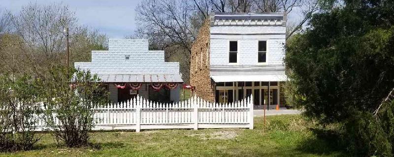
Arkansas, Washington County
00 :03 hrs
0.2 mi
27.152191 ft
Easy
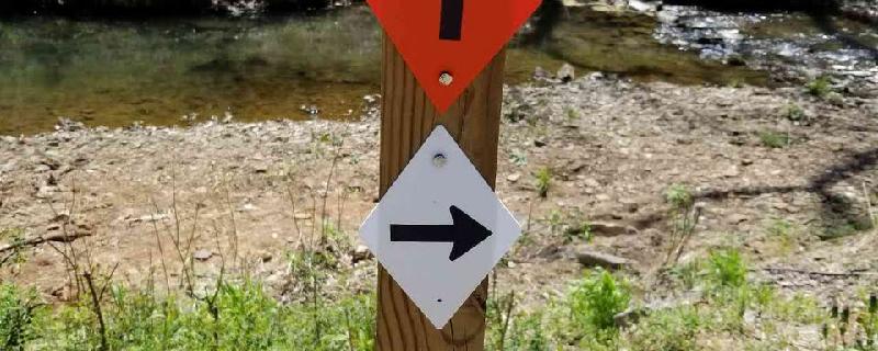
This easy loop is great for walking and running. Takes you by historic home ruins and down the Jordan Creek. Lots of wild flowers. It starts where the Earle Trail (orange diamonds) cross the creek.
Arkansas, Benton County
03 :23 hrs
8.2 mi
89.47098 ft
Moderate
This is a good beginner's backpacking trip. The trail is well worn and you'll have plenty of shade. It is very peaceful and has views of the lake. There are 5 sites for primitive camping.
Arkansas, Saline County
03 :44 hrs
20.7 mi
298.78662 ft
Expert
Easy drive. Amazing views. Not for those who do not like heights.
Arkansas, Washington County
00 :27 hrs
0.6 mi
34.678925 ft
Moderate
Very simple hike that takes you through Historic Cane Hill! You can even pick up a pamphlet at the museum that tells you about all the buildings you walk by! It takes you over a natural spring and on beautiful rock facings. You start at the cemetery so if you like spooky things check it out! Almost all the buildings you walk by are on the National register of Historic Places.
Arkansas, Garland County
02 :05 hrs
8 mi
78.95499 ft
Hard
Cedar Glades offers a great variety of long, fast sections, banked corners, climbs and downhill. There are some technical portions, rocky and root covered typical of the Ouachita region. Scenery on this ride is good too and it is just across the road from Hot Springs National Park so there is plenty to do in the area.
Arkansas, Lincoln County
04 :00 hrs
14.9 mi
16.511913 ft
Moderate
Riding at Cane Creek State Park you’ll find a well-constructed trail on rolling terrain. The surroundings vary from dense woodlands and cypress groves at a reservoirs edge to a grassy ride along a levee top adjacent to farmlands. This trail has many bridges including suspension bridges and some boardwalk riding through wetlands.
Arkansas, Montgomery County
04 :19 hrs
17 mi
278.50848 ft
Hard
This ride makes for a good day in the woods with excellent views, potentially dicey stream crossings and mountain solitude. The trail experiences significant elevation gain and a long downhill finish on a country road. The trail conditions are typical of the Ouachitas ranging from smooth to root covered and rocky. Bring enough water for a full day out.
Arkansas, Heber Springs
05 :19 hrs
54 mi
278.78748 ft
Expert
This ride tours the scenic country surrounding Greers Ferry Lake. Departing from the bustling community of Heber Springs the ride makes a long sustained climb along wood lined roadway reaching a summit just past Ida. You’ll continue on challenging, rolling asphalt though the towns of Greers Ferry and Pearson eventually returning to Heber Springs. Heber Springs, Drasco and Greers Ferry are the best spots along the tour to make pit stops and find services.
Arkansas, Havana
05 :38 hrs
57.1 mi
645.0718 ft
Expert
Departing from Havana this ride climbs into the Ozark National Forest to the summit of Mount Magazine. You’ll encounter reasonably steep grades as this road winds through dense woodlands and roughly fifteen miles of downhill excitement as you return to the farmlands below. Atop Mount Magazine you’ll find a full service lodge, cabin rentals and restaurants. The return to Havana is a meandering course through pastoral landscapes.
Arkansas, Harrison
05 :44 hrs
58.9 mi
450.87146 ft
Extreme
The ride from Harrison to Jasper also known fondly as the Jasper Disaster takes you through the flat farm country and then climbs steeply into Ozark hills. There are a few sustained climbs on this ride experienced as you pass from valley to valley. Grab a snack as you pass through Jasper as services are few and far between for he rest of the journey.
Mississippi, Greenwood
06 :09 hrs
61.5 mi
4.988125 ft
Extreme
The Bikes, Blues, and Bayous bicycle tour is held annually in Greenwood and Leflore counties. There is a 20-mile, 46-mile, and 62-mile course available. You can either enter to join this race or choose to do it on your own time. It is a beautiful ride with fantastic scenery and many great views. You will cross through forested areas, vast agricultural lands, cross rivers, pass through quaint towns, as well as the historic downtown of Greenwood. Parking is available on the street and is free throughout all of the downtown area. The ride is almost completely flat with very minor and gentle elevation changes.
Arkansas, Montgomery County
07 :56 hrs
30.3 mi
190.45631 ft
Expert
This extremely popular ride begins at North Fork Lake and follows wooded ridgeline and small drainages on some very entertaining terrain. There are many creek crossings but they are generally small or have bridges. This trail can often be quite narrow and some sections are fairly exposed. This is generally done as a point-to-point ride so a shuttle vehicle is required.
Arkansas, Mena
01 :40 hrs
12.8 mi
414.44315 ft
Hard
This stout climb takes you from the community of Mena into the mountains of the Ouachita National Forest. At the summit of this ride you’ll find Queen Wilhelmina State Park located atop the second highest mountain in Arkansas. Along the ride and from the top many nice views are to be enjoyed. Lodging is available at the state park.
Arkansas, Perry County
06 :20 hrs
63.8 mi
209.15645 ft
Extreme
This cycle tour takes you through some of the scenic country between the Arkansas River and the Ouachita National Forest. Beginning in Perry the route starts you on flat pavement but near the ten-mile mark a stout climb begins taking you to the summit of Petit Jean State Park. A speedy descent takes you back to the farmlands below where you’ll finish off the circuit. You’ll find facilities for pit sops in the community of Oppello and at the Petit Jean State Park Visitors Center.
Tennessee, Memphis
01 :20 hrs
6.7 mi
13.503349 ft
Moderate
Shelby Farms Greenline is built upon the bed of a former CSX Railroad line, which was abandoned in 2001. It is paved, shady and offers pleasant scenery in a peaceful setting. Wildlife abounds and it is enjoyed by all ages.
Arkansas, Stone County
03 :31 hrs
14.1 mi
164.34647 ft
Hard
This ride begins at the Syllamo trail complex and follows ridgeline and creek drainages to Blanchard Springs on the White River. Trail quality is generally good without major obstacles. The scenery and surroundings exist in a natural state of dense Ozark Woodlands with occasional views of the White River.
Arkansas, Flippin
03 :28 hrs
35.2 mi
191.14435 ft
Hard
This ride offers cyclist an excellent tour of Ozark hill country. Beginning in Flippin the tour takes you past agricultural lands surrounding Fallen Ash Road and then heads north out of Summit where you’ll find rolling hills and dense woodlands. The distant extent of the ride is Dodd City where you’ll begin to work your way back on winding roadway passing briefly by Bull Shoals Lake.
Arkansas, Montgomery County
06 :10 hrs
16.4 mi
237.9098 ft
Extreme
The Ouachita National Recreation Trail runs for over two hundred miles from Oklahoma to Lake Maumelle in Arkansas. The trail takes you through dense hardwood and evergreen forest and over and along many mountain ridges. This section of the trail begins at a trailhead off of Route 27 near Story Arkansas and takes you east through lush countryside to a trailhead near Lake Ouachita. Given the length of this leg of trail it is best enjoyed as an over-nighter. This is a one-way adventure so a shuttle vehicle is necessary; it can be linked with the next leg of the trail for a long through hike.
Arkansas, Jasper
05 :35 hrs
57.3 mi
457.51813 ft
Extreme
This tour through beautiful Ozark hill country is known for its excellent views, stout climbs and rural charm. The challenge starts right out of the gate in Jasper with the route gaining over one thousand feet in less than four miles. You’ll then descend and pass through the farming community of Mount Sherman and come to the Buffalo National River. Another challenging climb begins as you leave Boxley and once surmounted you are treated to miles of undulating roadway that returns you to Jasper.
Arkansas, Montgomery County
03 :56 hrs
14.5 mi
197.58064 ft
Expert
This is a longer out-and-back ride with a lot of variety and some great views. For over seven miles you’ll enjoy winding trail on rolling terrain as you roughly parallel the Lake Ouachita shoreline. The distant end of the trail begins to climb as you move away from the lake getting steeper and more technical as you go; obviously this makes for some great downhill action as you make the return. There are many access points to this ride so as you become more familiar with it you can just enjoy sections that cater to a lower skill level or do a shuttle just for the downhill section. The entirety of the ride takes place in dense woodlands existing in a largely natural state.
Arkansas, Eureka Springs
00 :55 hrs
3.5 mi
31.274902 ft
Hard
This loop features a mix of relatively smooth trail as it traverses the west side of Lake Leatherwood followed by rougher more challenging trail to the east. The scenery is excellent; Ozark hill country covered in dense hardwood and coniferous forest. You’ll likely be impressed by the quality of this trail as it was built and receives regular maintenance from the Ozark Off-Road Cyclists Club.
Arkansas, Bentonville
00 :53 hrs
3.4 mi
40.60019 ft
Expert
One of the main attractions of the Slaughter Pen Hollow bike park the Tatamagouche trail is an exciting and challenging ride with lots of tight corners and some board riding. Like all of the trails in the park Tatamagouche is an extremely well conceived track designed by IMBA and Progressive Trail Design.
Arkansas, Franklin County
03 :08 hrs
8 mi
268.7471 ft
Hard
This trail climbs across wooded hillside in the Ozark National Forest. A spur trail at the distant extent of the loop takes you to the Spy Rock Overlook, which offers excellent views of the surrounding hill country. The return descends a different ridge than the ascent keeping the adventure interesting. Bring plenty of water and be prepared for changing conditions.
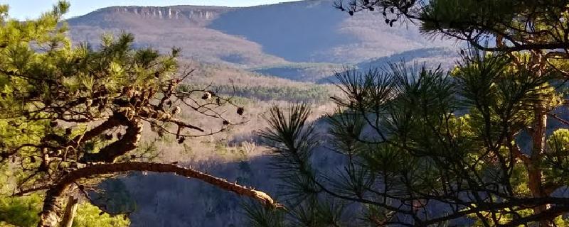
Arkansas, Washington County
05 :23 hrs
14.1 mi
250.66907 ft
Expert
The Butterfield Trail wanders for over fourteen miles through Ozark woodlands in the Devil’s Den State Park. The terrain consists of sandstone crags and dense hardwood and coniferous forest. The trail climbs over two ridges but is general just a nice trek through rolling hills. There are many side attractions in the area such as viewpoints, caves and swimming holes.
Arkansas, Pulaski County
01 :12 hrs
2.6 mi
211.41397 ft
Hard
This hike climbs steeply, with some scrambling at times to the summit of Pinnacle Mountain. From the top you’ll enjoy excellent views of Lake Maumelle and the surrounding woodlands. The route descends steeply off of the east side of the mountain and meanders through forest back to the trailhead.
Arkansas, Garland County
01 :07 hrs
4.5 mi
121.15204 ft
Expert
This ride climbs over two mountain ridges in dense woodlands near Lake Ouachita. The route is maintained by the U.S. Forest service and trail conditions are generally good. The nature of the terrain is highly variable with tight twisty sections, climbs, downhills, packed trail and some rocky bits.
Arkansas, Pike County
00 :18 hrs
0.8 mi
14.536003 ft
Unknown
Crater of Diamonds State Park Campground is a very unique area that holds dozens of different types of diamonds. Aside from searching for diamonds, visitors also enjoy seeing the variety of wildlife in the area as well as hiking, fishing, and more. There are a total of 59 standard campsites that all have access to laundry, restrooms, picnic sites, a cafe, and more. Along with that, there is also a lodge that can be rented from Memorial Day weekend through Labor Day weekend.
Arkansas, North Little Rock
00 :07 hrs
0.3 mi
4.1489944 ft
Unknown
Little Rock North/ Jct. I-40 Koa Campground is a beautiful campground that is heavily surrounded by trees that provide great shade and scenery. Offered within the campground is an ice cream parlor, fitness center, cabins for rent, a sauna, and much more. The Arkansas River Trail is accessible right from the campground. Some of the amenities offered include wifi, cable tv, a snack bar, propane, bike rentals, a pavilion, and more. Reservations are highly recommended from May until September.
Arkansas, Scott County
04 :09 hrs
10.8 mi
223.73167 ft
Extreme
The Ouachita National Recreation Trail runs for over two hundred miles from Oklahoma to Lake Maumelle in Arkansas. The trail takes you through dense hardwood and evergreen forest and over and along many mountain ridges. This section of the trail begins at Big Brushy Recreation Site and takes you east through lush countryside to Sim’s Loop Road. Given the length of this leg of trail it is best enjoyed as an over-nighter. This is a one-way adventure so a shuttle vehicle is necessary; it can be linked with the next leg of the trail for a long through hike.
Arkansas, Independence County
00 :08 hrs
0.4 mi
6.8910065 ft
Unknown
Rafter D Ranch Campground is a private campground that is located in the city of Mount Pleasant. This campground offers a total of 12 sites including tent and RV. Maximum RV length is 40 feet. Full hookups are available as well as tables, grills, water, showers, firewood, and horse pens. Campers here enjoy fishing, and hiking on the trails that snake throughout the area. Sites cost $21-30 per night.
Mississippi, Tate County
00 :36 hrs
1.8 mi
4.657799 ft
Easy
This hike incorporates sections of other park trails as it traverses the Appalachian foothills in Tishomingo State Park. The trail surface is mostly dirt with some rocky sections and a quick walk along the rocky bank of the Coldwater River on the return trip. The wooded scenery is attractive and the views are great.
Arkansas, Washington County
01 :19 hrs
5.1 mi
75.17276 ft
Hard
This ride is a mix of singletrack, dry creek bed and dirt road. Elevation change is minimal; you’ll find one climb of mild challenge and a minor but entertaining downhill section. The surroundings are dense hardwood and evergreen forest located in Devil’s Den State Park.
Arkansas, Baxter County
00 :17 hrs
0.8 mi
19.669006 ft
Unknown
Bidwell Point Park Campground is surrounded by Norfork Lake which provides great boating and water sport activities. Fishing here will not disappoint as you may find striped bass, crappie, and white bass. Sites have electric hookups and there are group sites available that can hold up to 200 guests. There is a playground for children as well as a wonderful swimming beach. Prices range from $20-$22 per night.
Arkansas, Perry County
00 :31 hrs
1.5 mi
7.2350006 ft
Unknown
Toad Suck Campground is located along the luscious banks of the Arkansas River and attracts visitors all over for its wonderful recreation. The many trees in the area, such as dogwood, redbud, wild plum, and more, provide great shade year round as well as beautiful views. Anglers can fish for bream, crappie, white bass, largemouth bass, and catfish. There are 48 campsites with electric and water hookups as well as five picnic shelters all with access to showers, a playground, and a boat ramp. Standard sites cost $18-$20 per night and the group shelters cost $50 per day.
Arkansas, Polk County
00 :08 hrs
0.3 mi
8.14798 ft
Unknown
Bard Springs campground is surrounded by the thick trees of the Ouachita National Forest. It is a fairly small campground that offers lots of water activities as well as opportunities for hiking and picnicking. This campground is open year round and is a very popular base camp for hikers in the Caney Creek Wilderness. Standard sites cost $8 per night.
Mississippi, Lafayette County
00 :43 hrs
2.8 mi
31.772728 ft
Hard
Located in the Clear Creek Recreation Area at Sardis Lake, the Intermediate Loop is one of three singletrack paths designed for mountain bikers. All three loops are at a different level of difficulty, allowing riders of all skill levels an opportunity in the same area. You will ride through a beautiful, thick hardwood forest on a mostly stable trail surface. Leaves and needles and possible small rocks or tree roots will be the only obstacles. There are great views over the lake and wonderful scenery.
Arkansas, Van Buren County
00 :06 hrs
0.3 mi
6.5410156 ft
Unknown
Brock Creek Lake Recreation Area Campground is located next to Brock Creek Lake which provides great views and recreational activities. Some of which include boating, water skiing, and other water activities, as well as fishing, nature viewing, OHV riding, picnicking, and more. This campground is open year round and welcomes boats up to the size of 10 hp. Vault toilets and plenty of other amenities are offered in the shady and heavily forested campsites.
Arkansas, Washington County
00 :47 hrs
2.1 mi
31.013 ft
Unknown
Lake Wedington Recreation Area Campground is a very modern campground that offers lots of great amenities and activities. Some of the popular activities in the area include volleyball, horseshoes, hiking, mountain biking, fishing, picnicking, and water activities. There are 6 reservable cabins as well as 18 campsites that have access to a bathhouse, flush toilets, a boat launch, a swimming area, and more. Sites cost $10 a day and cabins cost $70-80 per night.
Arkansas, Pulaski County
00 :35 hrs
1.8 mi
0.8690033 ft
Unknown
Willow Beach Campground is located right next to the dam along the Arkansas River. Recreational activities in the area will not disappoint. Some of which include picnicking, boating, sightseeing, hunting, and fishing for bass, crappie, and bream. The most popular thing to hunt here is deer and ducks. There are a total of 23 campsites that all offer electric and water hookups as well as two reservable group picnic shelters. Campers also have access to an on site boat ramp and playground.
Arkansas, Yell County
00 :16 hrs
0.8 mi
7.3779984 ft
Unknown
Sunlight Bay Campground is located along the shores of Nimrod Lake and Dam and lies in between the Ouachita and Ozark Mountains. Fishing is a very popular activity here as anglers may find catfish, bass, bluegill, and crappie. Boating, water skiing, and tubing are also some of the favorited activities in the area. Campers may see deer, turkey, quail, squirrel, rabbit, fox, mink, black bear, dove, and waterfowl roaming around. There are 29 modern and roomy campsites that offer access to an on-site boat ramp and playground. Sites cost $18-$40 per night.
Arkansas, Searcy County
00 :12 hrs
0.5 mi
16.419983 ft
Unknown
Richland Creek Recreation Area Campground is located in the Ozark National Forest and has great shade and privacy throughout the campground. There is a small stream that runs throughout the area and creates beautiful waterfalls. There are 11 family camping areas available and the campground is open year round. Roads getting into the campground are pretty rough so campers can bring trailers at their own risk. Activities in the area include fishing, hiking, nature viewing, picnicking, water activities, and more.
Arkansas, St. Francis County
00 :16 hrs
0.8 mi
3.3390007 ft
Unknown
Shell Lake Campground is a very modern and luxurious private campground located in the city of Heth. There are a total of 50 campsites offered here and 9 of which are tent sites. Maximum RV length is 50 feet. Full hookups are available at 20 sites and there are also 20 pull thrus throughout the campground. Campers have access to water, showers, a dump station, laundry facilities, internet, and more. Sites cost $21-$30 per night.
Arkansas, Pope County
00 :22 hrs
1 mi
23.770996 ft
Unknown
Moccasin Gap Horse Trail Campground is said to contain the best horse trails in the state and is very popular and heavily used. There are 4 loop trails that all link together at some point that are all surrounded by lots of trees that provide great shade. The area is also open to OHVs and high clearance vehicles. A total of 17 parking spurs are all available on a first come first serve basis and offer lots of amenities including showers, water, fire rings, and more.
Arkansas, Logan County
00 :10 hrs
0.4 mi
26.856003 ft
Unknown
Jack Creek Campground is located next to the beautiful waters of Jack Creek. There is a short hiking trail that runs throughout the area and is 4 miles in length. This heavily used campground is open from spring to fall and offers plenty of activities. Some of which include fishing, hiking, picnicking, and even water activities. There is not drinking water here unfortunately but there are picnic tables and vault toilets.
Arkansas, Baxter County
00 :44 hrs
1.9 mi
28.791 ft
Unknown
Robinson Point Campground is one of the most popular parks in the area and is known for its glorious aquatic activities. These activities include swimming, boating, hunting, hiking, and more. There are two separate peninsulas, so there are plenty of modern sites with electric hookups, and access to flush toilets and showers. A swim beach and boat ramp are also offered on site. Sites cost $20-$40 per night.
Arkansas, Benton County
00 :25 hrs
1 mi
45.61798 ft
Unknown
Lost Bridge North Campground is located right along the edge of Beaver Lake in the Ozark Mountains and offers very spacious sites. Anglers can find large and small mouth bass, crappie, bream, white bass, stripers, and channel or spoon bill catfish. Many miles of trails run throughout the area and are great for hiking, biking, and wildlife viewing. Other popular activities include boating, swimming, picnicking, scuba diving, water skiing, spelunking, and sightseeing. Campsites are very large with plenty of shade and access to drinking water, flush toilets, fire rings, picnic areas, and more. Sites cost $20-$25 per night.
Arkansas, Cleburne County
00 :26 hrs
1.3 mi
8.067001 ft
Unknown
John F Kennedy Campground lies along the edge of the Little Red River in the stunning Ozark Mountains. This campground is named after John F Kennedy because this was where he stood in one of his last major appearances. A beautiful variety of trees can be found in the area that provide great shade. Activities in the area include boating, sailing, water skiing, swimming, scuba diving, and fishing opportunities. There are a total of 73 sites with electric hookups and some with water hookups. Amenities include showers, flush toilets, a boat ramp, a picnic shelter, and more. Sites cost between $17 and $22.
Arkansas, Cleburne County
00 :15 hrs
0.7 mi
14.381012 ft
Unknown
Narrows Campground sites right along Greers Ferry Lake in the stunning Ozark Mountains. Campers can enjoy the beautiful variety of trees year round as well as fishing, sailing, water skiing, swimming, scuba diving, boating, and hiking along the paved trail that runs throughout the campground. There are a total of 59 sites that all have electric hookups as well as access to toilets, drinking water, showers, a dump station, picnic shelters, and a boat ramp. Sites cost from $17 to $19 per night.
Arkansas, Chicot County
00 :41 hrs
2 mi
2.713997 ft
Unknown
Lake Chicot State Park Campground is known for its abundance of recreational activities and beauty. Anglers can enjoy fishing for crappie, bass, bream, catfish, and more. Other activities include swimming, bicycling, boating, and hiking. There are a total of 122 campsites that all have access to sewer hookups, pavilions, a swimming pool, laundry , a fishing dock, a boat ramp, a store, and even more.
Arkansas, Franklin County
00 :27 hrs
1.2 mi
15.533005 ft
Unknown
Shores Lake Recreation Area Campground is a very modern campground with lots of activities and amenities available. There are 19 single sites and 4 multiple unit sites as well as 28 picnicking units. Some sites have electric hookups and there are no dump stations. Fishing for bass is very popular here, and visitors also enjoy boating, hiking, picnicking, and more. Hot showers and drinking water are accessible. Sites are first come first serve and cost $6-$18 per day.
Arkansas, Clark County
01 :12 hrs
4.7 mi
79.88298 ft
Expert
This ride offers some fast riding and an exciting downhill through mixed hardwoods and evergreens near De Grey Lake. The ride reaches its low point and then follows Channel Road for a short distance before diving back into the woods for a sustained climb back to the parking area. The trail surface is generally pretty smooth particularly for the area.
Arkansas, Pike County
00 :02 hrs
0.1 mi
2.472992 ft
Unknown
Caddo River Campground is a very small campground surrounded by lots of trees and great scenery. This private campground is located in the city of Glenwood and has a total of 30 sites available. Ten of these are tent sites and 6 of the sites have electric and water hookups. Each site has access to tables, grills, water, toilets, showers, and more. Sites only cost $1-11 per night.
Arkansas, Pulaski County
00 :54 hrs
2.7 mi
2.6039963 ft
Unknown
Maumelle Campground is located right along the bank of the Arkansas River which provides plenty of aquatic activities. Campers can enjoy boating, fishing, birding, and hiking on the trail that runs throughout the campground. Anglers will find crappie, bream, hybrid bass, white bass, and more. There are a total of 128 campsites that are all very spacious and offer access to electric hookups, picnic shelters, a boat ramp and dock, hot showers, and a playground for children. Sites cost $22-$26 per night.
Arkansas, Stone County
00 :12 hrs
0.5 mi
14.330002 ft
Unknown
Gunner Pool Recreation Area Campground is located in a very beautiful area that is very shaded and private. Hunting for whitetail deer, turkey, black bear, and squirrel is very popular here. Other popular activities include hiking, float fishing, canoeing, and more. Sites cost $7 a day and offer grills, tables, lantern poles, and tent pads. However there is not electric or water hookups available here, but drinking water is available.
Arkansas, Montgomery County
00 :56 hrs
2.6 mi
13.966995 ft
Unknown
Denby Point Campground is known for its beautiful views and is located in the Ouachita Mountains. Campers enjoy fishing, jet skiing, boating, hiking, and more. There are a total of 67 sites and 58 of which offer electric hookups. A boat ramp is also offered on site. One way to enjoy the beautiful views of the lake is to follow the Geo Float Trail which is 16 miles round trip and is self-guided. Sites cost $14-$22 per night.
Arkansas, Garland County
00 :08 hrs
0.4 mi
3.161003 ft
Unknown
Treasure Isle RV Park is a private RV park but offers tent camping as well. There are a total of 65 sites available and all of which offer full hookups. Maximum RV length is 45 feet and there are 45 pull thru sites. Some of the popular activities in the area include swimming, boating, fishing, and many more aquatic activities. Campers have access to laundry facilities, cable tv, a pool, a playground, and a boat launch on site. Sites cost $41-50 per night.
Arkansas, Arkansas County
00 :13 hrs
0.6 mi
3.1569977 ft
Unknown
Wilbur D. Mills Campground is a very small and rustic campground located just downstream of the Dam on the Arkansas River. Bird lovers will not be disappointed here as there are many great species to see. Some of the most popular activities in the area include hiking, fishing, and boating. There are a total of 21 campsites and 17 of which are reservable. Each has electrical hookups as well as access to hot showers and a boat launch on site. Standard sites cost $16 per night.
Arkansas, Crittenden County
00 :08 hrs
0.4 mi
0.45800018 ft
Unknown
Memphis Koa Campground is a great and lively campground that offers many great original activities. This campground offers tours which include Elvis Presley’s Graceland. Sites are shaded and have room for just about any rig. Some of the activities here include swimming, biking, throwing horseshoes, and more. Amenities offered include wifi, propane, cable tv, firewood, pull thrus, and more. The pool is open from May until September. Maximum pull thru length is 70 feet.
Arkansas, Perry County
06 :18 hrs
63.2 mi
62.329163 ft
Extreme
This ride begins in the small community of Perryville and circumnavigates the Ouachita ridge system associated with Ola Mountain. The route begins with some short but challenging climbs and then covers rolling farmlands and tree-lined highway. The distant extent of the tour is Plainview where the course doubles back east passing Nimrod Lake.
Arkansas, Independence County
00 :08 hrs
0.4 mi
6.8910065 ft
Unknown
Rafter D Ranch Campground is a private campground that is located in the city of Mount Pleasant. This campground offers a total of 12 sites including tent and RV. Maximum RV length is 40 feet. Full hookups are available as well as tables, grills, water, showers, firewood, and horse pens. Campers here enjoy fishing, and hiking on the trails that snake throughout the area. Sites cost $21-30 per night.
Arkansas, Russellville
00 :22 hrs
1.1 mi
1.6559982 ft
Unknown
Old Post Road Campground is located on the edge of Dardanelle Lake. This area is known for its various species of birds, especially bald eagles. Campers enjoy boating, biking, hiking, birding, and fishing. A biking trail is also offered within the campground along with soccer fields, baseball fields, and tennis courts. A total of 37 reservable campsites are available and each have water and electric hookups. A playground for children, and a boat ramp are located on site. Sites cost $20 per night.
Arkansas, Baxter County
00 :50 hrs
2.2 mi
30.093002 ft
Unknown
Gamaliel Campground is located along the banks of Norfork Lake and has greatly shaded campsites. Sailing and scuba diving are two of the most popular activities here as well as fishing for bass up to 40 pounds. A total of 64 sites are offered all with electric hookups and drinking water. A boat ramp is offered on site as well as a swim beach and a playground for children. Sites cost about $40 per night.
Arkansas, Howard County
00 :27 hrs
1.4 mi
3.4960022 ft
Unknown
Cottonshed Park Campground is located along the shores of Millwood Lake. It offers a total of 44 standard electric sites. Campsites offer many amenities such as picnic tables, grills, fire rings, lantern poles, and more. Millwood lake is known for its great fishing opportunities as well as beautiful views. Duck hunters will enjoy the 300 bird species roaming the area. A boat dock is located on site which is very convenient. Sites each cost $15 per night.
Arkansas, Benton County
00 :11 hrs
0.5 mi
7.6889954 ft
Unknown
Beaver Lake Hide A Way Campground is a very open and spacious private campground located in the city of Rogers. There are a total of 130 campsites available and 40 of which are tent only sites. Full hookups are available at 60 sites, and there are 20 pull thus located throughout the campground. All sites have access to tables, water, toilets, showers, dump, RV storage, laundry facilities, firewood, internet, a pool, a playground, and more. Each site costs $21-30 per night.
Arkansas, Boone County
00 :37 hrs
1.6 mi
42.864014 ft
Unknown
Cricket Creek Campground is a very roomy campground that sits along Table Rock Lake. A marina with boat tube, ski, and wakeboard rentals is located on site as well as a nice sandy swimming beach. Anglers will enjoy the opportunity to fish for crappie, catfish, bluegill, and bass. There are 37 reservable campsites available that offer amenities like hot showers, drinking water, a dump station, and electric hookups. Pricing is right around $21-$23 per night.
Arkansas, Howard County
00 :21 hrs
0.9 mi
12.701996 ft
Unknown
Big Coon Creek Campground offers a total of 31 sites that are located along the banks of Gillham Lake. Boating is a very popular activity here and there is even a boat ramp on site. Anglers may enjoy fishing for small mouth and large mouth bass as well as spotted bass, saugeye, crappie, catfish, and sunfish. Amenities offered include water and electric hookups, a playground for children, hot showers, a dump station, and more. Prices range from $14-$16 per night.
Arkansas, Clark County
01 :32 hrs
5.9 mi
62.903793 ft
Hard
This ride is a long gentle downhill over rolling terrain to the edge of De Grey Lake and then a shorter but not terribly strenuous climb back to the parking area. The trail surface is generally pretty smooth particularly for the area. Riding here you’ll enjoy a winding route through a largely unspoiled hardwood forest.
Arkansas, Benton County
00 :32 hrs
1.4 mi
35.728973 ft
Unknown
Indian Creek Campground sits along the edge of Beaver Lake in the Ozark Mountains. This area is known for its natural caves, limestone bluffs, and wide variety of trees and flowers. Anglers will not be disappointed as they may find large and small-mouth bass, crappie, bream, white bass, stripers, and channel or spoon-bill catfish. Hiking and biking trails run throughout the campground. Activities in the area include boating, swimming, picnicking, scuba diving, water skiing, spelunking, and sightseeing. This campground has plenty of large and spacious campsites with plenty of shade and amenities. Sites cost between $20-$40 per night.
Arkansas, Washington County
00 :42 hrs
1.8 mi
30.903015 ft
Unknown
Lake Wedington Campground attracts people from all over and is an overall wonderful campground. There are rental cabins, picnic sites, and more available. A wide variety of trees offer beautiful views in the fall as well as great shade. A swimming area, boat ramp, and fishing pier are all offered on site and visitors can enjoy boating, kayaking, canoeing, fishing, hiking, mountain biking, horseback riding, and more. Although horseback riding is popular here, horses must be kept outside the park. There are 6 cabins, 2 group shelters, and 18 standard campsites. Cabins cost $70-$80 per night, standard sites are $10 per night, and group shelters range from $30-$150.
Arkansas, Scott County
00 :24 hrs
1.1 mi
20.97499 ft
Unknown
Little Pines Campground is a pretty new and modern campground that has tons of great amenities and activities. Some popular activities in the area include hiking, swimming, boating, and fishing for bass, crappie, bream, sunfish, and catfish. Each site has access to a boat ramp, picnic tables, toilets, drinking water, parking,and more. No skiing is allowed on the lake, but there are plenty of other water activities available. Water and electrical hookups can be found at most sites.
Arkansas, Conway
01 :03 hrs
4.1 mi
40.389526 ft
Expert
This winding route explores Cadron Settlement Park at the edge of the Arkansas River. It’s characterized by the many short steep climbs and descents and rock and root studded trail. The surroundings are pleasant, the hardwood and evergreen woodlands near Conway with occasional views of the river.
Arkansas, Garland County
01 :42 hrs
4.3 mi
144.22449 ft
Moderate
This hike takes you past springs and woodland pools under the dense canopy of hardwood and evergreen forest. The trail climbs gradually as it meanders but grades are never overly challenging. As you walk you’ll see the well-built trail infrastructure put in place by the Civilian Conservation Corps in the 1930’s.
Arkansas, Logan County
00 :41 hrs
1.8 mi
26.936005 ft
Unknown
Cove Lake Recreation Area Campground is located near the highest point in Arkansas which is Mount Magazine. This campground offers a wide variety of activities such as swimming, fishing, hiking, water skiing, and more. A boat ramp is included on site. Anglers can enjoy fishing for catfish, largemouth bass, bluegill, sunfish, crappie, and perch. A total of 20 standard electric campsites are offered and each site includes a table and a grill as well as access to flush toilets, hot showers, and drinking water. Pricing is right around $9-$10 per night.
Arkansas, Johnson County
00 :15 hrs
0.6 mi
42.017 ft
Unknown
Haw Creek Falls Recreation Area Campground is surrounded by the beautiful Ozark National Forest. Nearby is the beautiful Big Piney river as well as the Ozark Highlands hiking trail that snakes throughout the area. Sites are available on a first come first serve basis and cost $4 a day. Popular activities in the area include fishing, hiking, nature viewing, and more. No drinking water or special facilities are available here unfortunately.
Arkansas, Madison County
00 :11 hrs
0.5 mi
8.692017 ft
Unknown
Withrow Springs State Park Campground is located in a very secluded and peaceful setting and has plenty of activities for campers of all ages. Some of these activities include Hiking, swimming, playing tennis, and fishing for catfish, bream, perch, and bass. A total of 30 campsites are available that all have electric, water, and sewer hookups as well as access to a free bathhouse, rental canoes, picnic sites, pavilions, and more.
Arkansas, Desha County
00 :15 hrs
0.8 mi
1.2870026 ft
Unknown
Pendleton Bend Campground is located along the Arkansas River and offers views of beautiful birds throughout the year. Visitors enjoy hiking, boating, hunting, and fishing for bass, crappie, and catfish. A total of 31 campsites are offered and include water and electric hookups. Twenty five of the campgrounds can be reserved and each has access to hot showers, a picnic shelter, a playground for children, and a boat ramp within the campground. Sites cost $16-$19 per night.
Arkansas, Cross County
00 :19 hrs
0.9 mi
6.8969955 ft
Unknown
Village Creek State Park Campground is located in a very unique area with a wide variety of beautiful trees. Hiking is very popular here as there are multiple different trails that run throughout the area. Other popular activities include horseback riding, golfing, swimming, and more. There are a total of 96 campsites as well as multiple cabins that can be rented. All sites have access to playgrounds, baseball fields, pavilions, picnic areas, and more.
Arkansas, Garland County
00 :36 hrs
1.6 mi
14.212006 ft
Unknown
Lake Ouachita State Park Campground is a stunning campground and has great recreation thanks to the beautiful lake. There are cabins that can be rented and have tons of amenities including a kitchen and television. No pets are allowed in the cabins however. There are a total of 50 campsites and some of them have electric and sewer hookups. Some of the popular activities in the area include hiking, swimming, boating, water skiing, scuba diving, and fishing for bream, crappie, catfish, stripers, and bass.
Arkansas, Sevier County
00 :30 hrs
1.3 mi
27.261993 ft
Unknown
Oak Grove Campground is located along the banks of DeQueen Lake in southwest Arkansas. Boating and water sports are some of the most popular activities here along with hiking along the trail that runs throughout the campground. Fishing is popular as well as anglers may find many species of bass, crappie, catfish, and sunfish. There are a total of 36 spacious campsites that have access to toilets, showers, drinking water, and more. There is also a large reservable group picnic shelter available. Standard sites are $14-$16 per night and the group shelter is $25-$35 per day.
Arkansas, Clark County
00 :19 hrs
0.9 mi
9.034996 ft
Unknown
Alpine Ridge Campground is a great campground surrounded by DeGray Lake. This lake is beautiful and creates a wonderful camping experience as it offers fishing, boating, swimming, and more. There is even a boat launch on site. Flush toilets, hot showers, drinking water, electric hookups, a dump station, and more are all offered as well. Sites range from $14-$18 per night.
Arkansas, Clark County
00 :37 hrs
1.7 mi
23.268997 ft
Unknown
Iron Mountain Campground runs along the banks of DeGray Lake in the Quachita Mountains. Hiking and horseback riding trails run everywhere throughout the area around the lake shore. Activities in the area include golfing, tennis, boating, water skiing, kayaking, and other water sports. There are 69 RV and standard campsites with electric hookups and all of which have access to the on site boat ramp and marina, hot showers, a playground, and other amenities. Sites cost $14 per night.
Arkansas, Yell County
00 :20 hrs
0.6 mi
81.06 ft
Unknown
Fourche Mountain Recreation Area Campground is located in the thick trees of the Ouachita National Forest. It is located just 5 miles south of the city Rover. Unfortunately there is no water or electricity here, but there are plenty of great activities to enjoy. Sites are available on a first come first serve basis. Picnic tables and toilets are located throughout the campground and are accessible to campers.
Arkansas, Hot Spring County
00 :43 hrs
2 mi
17.548996 ft
Unknown
Caddo Drive Campground is located along the banks of Degray lake in the Quachita Mountains. This area was actually awarded one of Americas top 25 scenic views. The lake provides plenty of aquatic activities such as swimming, boating ,and jet skiing. Aside from that Degray Lake hosts tons of professional fishing tournaments throughout the year. A boat ramp and swimming beach are offered on site. Sites cost $14 per night.
Arkansas, Montgomery County
01 :09 hrs
3 mi
12.812012 ft
Unknown
Joplin Campground is located along the edge of Lake Ouachita. The lake is beautiful and offers great fishing opportunities for anglers who may come away with a world class striper. Freshwater jellyfish can also be found within the lake. Visitors here enjoy hiking, biking, scenic driving, water skiing, fishing, and hunting. Sites all have electric hookups but are fairly small and unpaved. Amenities include a dump station, hot showers, a boat ramp, and a swim beach. Pricing is right around $14-$16 per night.
Arkansas, Benton County
00 :39 hrs
6.6 mi
80.45935 ft
Moderate
This short loop takes cyclists on a tour of the site of the Battle of Pea Ridge. Open fields and woodlands line the roadway of this historically preserved portion of northwestern Arkansas. You’ll encounter several interpretive sites and historic structures on the route as well as a few short climbs.
Arkansas, Greers Ferry
00 :38 hrs
1.7 mi
25.225006 ft
Unknown
Devils Fork Campground is located along the banks of Greers Ferry Lake in the Ozark Mountains. This is the ideal location for fishing, boating, sailing, water skiing, swimming, scuba diving, and hiking. Leaves are especially beautiful here in the fall thanks to the red cedar, black gum, red oak, elm, pecan, and sweet gum trees. There are a total of 55 sites all with electric hookups and access to flush toilets, drinking water, showers, a playground, and a swimming area. Sites cost from around $17 to $22 per night.
Mississippi, Rosedale
00 :37 hrs
0.9 mi
8.182446 ft
Moderate
Located within the Great River Road State Park, the Sandbar Trail takes you from the Mississippi River shoreline, over a waterside sandbar, and to the edge of the massive river. It is quite an unusual hike as it is almost completely along a large sandbar on the river bank. The loose terrain makes it somewhat difficult to hike on. The hike is open all year, but the sandbar is the most exposed during fall.
Arkansas, Arkansas County
00 :55 hrs
2.7 mi
2.9819984 ft
Unknown
Merrisach Lake Campground is located in the forest of eastern Arkansas and sits along the lakes edge which makes for tons of great activities. Visitors may enjoy picnicking, boating, and world class bass and crappie fishing. There are 67 standard campsites and most of which have electric hookups. There are also two large picnic shelters that can hold up to 75 people each. All sites offer access to hot showers, a playground, a boat ramp, and a dump station. Standard sites are from $11 to $19 per night and group shelters are $30-$40 per day.
Arkansas, Jefferson County
00 :38 hrs
1.9 mi
2.3330002 ft
Unknown
Tar Campground is famous for its beautiful scenery and great fishing as well as boating, picnicking, hunting, and more. Anglers may find bass, crappie, bream, and more. Campers have access to an on site playground and picnic tables. There are a total of 50 sites that all have access to electric and water hookups as well as grills, campfire rings, and more. Two reservable group picnic shelters are available and can hold up to 60 people each. Standard sites cost $9-$18 per night and group shelters cost $60 per day.
Arkansas, Lawrence County
00 :06 hrs
0.3 mi
1.2689972 ft
Unknown
Almost Home RV Park and Campground is a private campground that is surrounded by tons of beautiful trees. Located in the city of Walnut Ridge, this campground offers a total of 27 sites. Twelve of these are tent sites and maximum RV length is 50 feet. Full hookups are available at 25 sites and there are 10 pull thrus. Some popular activities in the area include hiking on the many trails in the area, and more. Campers all have access to tables, water, toilets, showers, RV storage, dump, internet, cable tv, a playground for children, and more.
Arkansas, Marion County
01 :21 hrs
3.5 mi
83.478 ft
Unknown
Buffalo Point Campground offers a variety of campsites such as 8 group areas, 83 standard electric, and 21 walk to sites. This campground is located along the banks of the Buffalo National River which provides river sports and great hiking opportunities. A restaurant is offered on site from Memorial day to Labor day. An amazing cave called Blanchard Springs Cavern is located approximately one hour away from Buffalo Point. Prices range anywhere from $16-$53 per night.
Arkansas, Little River County
00 :18 hrs
0.9 mi
6.4939957 ft
Unknown
White Cliffs Park Campground lies along the east bank of the Little River that runs into Millwood Lake. There is plenty to see in this area including unique topography like knolls, ridges, and ravines. Campers enjoy fishing for largemouth bass, white bass, striped bass, spotted bass, catfish, bluegill, sunfish, buffalo carp, and drum. Duck hunting, and hiking along the nature trail running throughout the campground are also some popular activities. A total of 25 sites are offered that are paved and offer water and electricity as well as access to flush toilets, showers, a boat ramp, a playground, and more. Sites cost $15-$21 per night.
Arkansas, Hempstead County
00 :20 hrs
0.8 mi
30.917 ft
Unknown
Beards Bluff Park Campground is located just 13 miles east of Ashdown. Views in the area will not disappoint from the beautiful sunset and lake views to spotting the beautiful birds. The campground lines the shore of Millwood Lake which creates great fishing opportunities. A total of 22 sites are available to campers. A boat and fishing dock are both located on site as well as electric and water hookups, showers, flush toilets, and more. Prices range from $15-$21 per night.
Arkansas, Franklin County
00 :11 hrs
0.5 mi
5.5079956 ft
Unknown
Redding Recreation Area Campground is a very stunning campground and is located right next to Mulberry River. Plenty of trees are in the area and provide great shade and privacy. This campground is fairly modern and offers flush toilets, warm showers, drinking water, and more. Visitors can enjoy hiking, fishing, nature viewing, picnicking, and water activities. Sites each cost $10 per day, and an additional $3 for additional vehicles.
Arkansas, Polk County
00 :36 hrs
1.6 mi
18.493988 ft
Unknown
Shady Lake Campground is a very secluded campground that is surrounded by lots of trees and vegetation. The Shady Lake Trail runs along the creek and is a beautiful hiking trail that can be used by mountain bikers and hikers. This campground is heavily used and on some rare occasions can flood. There is a swimming area as well as 4 separate camping loops, and most of which have electric or full hookups and access to flush toilets. Maximum RV length is 32 feet.
Arkansas, Yell County
00 :27 hrs
1.2 mi
13.320999 ft
Unknown
Waveland Park Campground is located along the edges of Blue Mountain Lake which provides plenty of activities and beautiful scenery. Some of the popular activities here include boating, hunting, hiking, water skiing, hunting, and even fishing for crappie, large mouth bass, small mouth bass, bream, and catfish. A swimming area, playground, amphitheater, and boat ramp are all accessible to campers. There are 38 shaded campsites throughout the campground with electric hookups and access to a group shelter that can hold up to 150 people. Standard sites cost $18-$20 per night and the group shelter costs $40 per day.
Arkansas, Franklin County
00 :21 hrs
0.9 mi
27.335999 ft
Unknown
White Rock Mountain Recreation Area Campground is located in a very beautiful area and offers cabins containing beautiful views of the area. There are several trails that run throughout the area that intersect with Ozark Highlands Trail. A lodge can be rented and holds up to 30 people. Aside from that there are 8 family camping units and 8 family picnicking units. Cabins cost $70 per night, the lodge is $150 per day, and campsites are $5 per night.
Arkansas, Cleburne County
01 :09 hrs
3.1 mi
16.404999 ft
Unknown
Old Highway 25 Campground is located along the shores of Greers Ferry Lake in the Ozark Mountains. This ideal environment provides great activities such as camping, fishing, boating, hiking, sailing, water skiing, swimming, scuba diving, and more. Two hiking trails run throughout the area and offer great views. A total of 120 campsites are available and approximately 84 of them have electrical hookups. Each site also has access to toilets, showers, a dump station, picnic shelter, swimming beach, and a boat ramp. Sites cost $14-$20 per night.
Arkansas, Benton County
00 :59 hrs
2.6 mi
34.533997 ft
Unknown
Rocky Branch Campground is located along the shores of Beaver Lake in the Ozark Mountains. Anglers may enjoy fishing for small-mouth bass, crappie, bream, white bass, stripers, and catfish. Other activities in the area include hiking, biking, hunting, boating, swimming, scuba diving, water skiing, and more. Plenty of large campsites are offered in the area with great shade and access to drinking water, picnic areas, flush toilets, a boat ramp, and a playground. Standard sites cost $20 per night and the group shelter costs $75 per night.
Arkansas, Howard County
00 :15 hrs
0.7 mi
8.220001 ft
Unknown
Cossatot Reef Campground is located right along the edge of Gillham Lake. This campground is known for its boating opportunities and there is even a boat ramp on site. Anglers will enjoy opportunities to fish for smallmouth and largemouth bass, crappie, channel and flathead catfish, and sunfish. A nature trail runs throughout the campground and offers beautiful views. Hot showers, drinking water, and flush toilets are all offered. Pricing is right around $14-$16 per night.
Arkansas, Nevada County
00 :11 hrs
0.5 mi
8.856003 ft
Unknown
White Oak Lake State Park Campground is a very abundant in wildlife where you may see things such as bald eagles, egret, and many more rare species. Anglers will enjoy fishing for bass, crappie, catfish, and bream. There are a total of 45 campsites that all have access to a store, marina with boat rentals, launch ramp, fishing pier, bicycle rentals, pavilion, picnic areas, hiking trails, and a playground for children.
Arkansas, Hot Spring County
00 :29 hrs
1.4 mi
9.267006 ft
Unknown
Shouse Ford Campground is located along the edge of DeGray Lake in the Quachita Mountains which make for great views and recreational activities. Some of which include boating, water skiing, kayaking, hiking, horseback riding, and fishing for striped bass. A total of 100 reservable campsites are available that are modern and offer electric hookups as well as access to flush toilets, hot showers, swimming beaches, an amphitheater, and a boat ramp. Sites cost $10-$18 per night.
Arkansas, Washington County
00 :53 hrs
2.4 mi
33.873993 ft
Unknown
Devils Den State Park Campground is located right next to Lee Creek and offers endless activities. Some of which include hiking, backpacking, mountain biking, and more. Cabins are available for rent and include a kitchen, bathroom, heater/air conditioner, and just about anything else you could need. There are a few different camping areas that make up a total of 144 sites. Some of which offer water and electric hookups.
Arkansas, Perry County
00 :18 hrs
0.8 mi
19.024002 ft
Unknown
Quarry Cove Campground is located along the edge of Nimrod Lake and dam located in the Ozark Mountains. Anglers come from all over to fish for catfish, bluegill, bass, and crappie. Other activities include boating, water skiing, tubing, and hunting for deer, turkey, quail, squirrel, rabbit, fox, mink, black bear, dove, and waterfowl. A total of 31 sites are offered as well as a large picnic shelter. Campers also have access to a swimming beach, a boat ramp, and a playground. Standard sites cost $18-$36 per night and the group shelter is $40 a day.
Arkansas, Arkansas County
00 :12 hrs
0.6 mi
1.0470009 ft
Unknown
Notrebes Bend Park Campground is located along the banks of the Arkansas River right next to Merrisach Lake. It is also located along the Mississippi Flyway which millions of migratory birds travel through each year. Visitors enjoy boating, hiking, birding, and fishing. Anglers may enjoy fishing for largemouth bass, crappie, bream, and catfish. There are a total of 30 campsites available all with access to electric hookups, drinking water, and campfire rings. Sites cost $19 per night.
Arkansas, Benton County
01 :19 hrs
3.7 mi
12.048004 ft
Unknown
Hickory Creek Park Campground is located along the shores of Beaver Lake in the Ozark Mountains. This park features limestone bluffs, natural caves, and tons of trees and flowers. Anglers will not be disappointed here as they may fish for large and smallmouth bass, crappie, bream, white bass, stripers, and channel or spoon-bill catfish. Miles and miles of hiking and biking trails run throughout the area. There are a total of 55 standard electric sites and 2 group shelters that all have access to campfire rings, picnic areas, flush toilets, and more. Group sites cost $75 per day and standard sites cost between $21-$25 per night.
Arkansas, Franklin County
04 :49 hrs
12.1 mi
495.25922 ft
Expert
This long loop begins near the White Rock campground and wanders through dense woodlands in Arkansas hill country. The trail descend quickly, the hillsides it crosses offering views of valleys below. At the southern extent of the journey you’ll find Shores Lake and the campgrounds surrounding. The walk back north explores a canyon occupied by White Rock Creek and passes a waterfall and a cascade.
Mississippi, Tate County
01 :30 hrs
4.4 mi
25.527279 ft
Moderate
The Coldwater Nature Trail is situated below the dam of Arkabutla Lake. The path is well marked, and has different routes that can create shorter loops around the lake. The last bit of the trail follows the Big Oak Nature Trail near Coldwater River. You will traverse through dense bottomland forest with many signs of wildlife habitation all around.
Arkansas, Garland County
01 :24 hrs
3.6 mi
45.38562 ft
Moderate
This hike provides a pleasant hike through Arkansas woodlands. The loop tours a small peninsula jutting onto Lake Ouachita. A viewpoint at the distant extent of the hike provides excellent lake views and a spot to rest. Trail users are encouraged to register at the trailhead.
Arkansas, Montgomery County
01 :01 hrs
2.9 mi
11.552002 ft
Unknown
Tompkins Bend Campground is located in the lush quiet mountains and is an ideal location. It is located next to Lake Ouachita which provides plenty of aquatic activities such as water skiing, jet skiing, and more. Hikers can enjoy the trail that runs throughout the campground and may see a variety of wildlife while walking along the trail. The spacious campsites all have electric hookups and some have water hookups as well as access to a dump station, showers, a boat ramp, and an amphitheater. Sites cost $14-$20 per night.
Arkansas, Heber Springs
00 :57 hrs
2.6 mi
28.826996 ft
Unknown
Heber Springs Campground is located along the banks of Greers Ferry Lake in the Ozark Mountains. The environment here provides great opportunities for fishing, boating, hiking, sailing, water skiing, swimming, and scuba diving. The great variety of trees in the area provide stunning views in the fall and great shade throughout the year. A total of 136 sites are offered here and 101 of which have electric hookups as well as access to toilets, showers, a dump station, and more. Pricing ranges from $14-$20 per night.
Arkansas, Pike County
01 :09 hrs
3.1 mi
19.929993 ft
Unknown
Cowhide Cove Campground is located along the banks of Lake Greeson and offers lots of water sport activities and hiking along the lake shore. Anglers will enjoy the opportunity to fish for largemouth, striped, spotted, smallmouth, and white bass as well as flathead and channel catfish, black and white crappie, walleye, and bluegill. This campground offers a total of 50 campsites and 2 of which are tent only sites without electric hookups, the rest have electric hookups. Lots of great amenities are offered such as hot showers, a boat ramp, a playground, a swim beach, grills, and more. Prices range from $14-$20 per night.
Arkansas, Newton County
00 :55 hrs
2.4 mi
82.71503 ft
Moderate
This hike takes you through hardwoods and evergreens in the Ozark National Forest. The route follows a ridgeline above Big Devils Fork to a beautiful sandstone formation. The Sand Castle is a small cave with several arches and natural windows. The hike experiences minimal elevation change, making it only moderately strenuous.
Arkansas, Carroll County
00 :28 hrs
1.3 mi
10.194 ft
Unknown
Dam Site Lake Campground is located along the edge of Beaver Lake in the Ozark Mountains. Scenery in the area will not disappoint, there are natural caves and beautiful trees and flowers. Fishing opportunities in the area are great as anglers can fish for large and small mouth bass, crappie, bream, white bass, stripers, and channel or spoon-bill catfish. Tons of hiking trails run throughout the area and hunters have great opportunities to find deer, rabbits, and squirrels. Other activities here include boating, swimming, picnicking, scuba diving, and water skiing. Campgrounds are large and spacious with plenty of shade. Prices range from $18-$25 per night.
Arkansas, Franklin County
00 :08 hrs
0.4 mi
0.29100037 ft
Unknown
Aux Arc Campground is located right along the shores of Ozark Lake. There are a total of 91 campsites and a huge variety of activities are available here. Some of which include boating, hiking, picnicking, and fishing for catfish, bream, crappie, and bass. Wildlife in the area will not disappoint, and hunting for big and small game is also a popular activity here. Electric hookups are available as well as two playgrounds for children and hot showers. Pricing ranges from $10-$20 per night.
Arkansas, Montgomery County
00 :23 hrs
1.1 mi
8.779007 ft
Unknown
Highway 27 Fishing Village Campground is a private campground that is run on Army Corps land. This campground is very large and offers plenty of sites including tent and trailer sites. Campers all have access to electric and water hookups as well as an on site store. Some popular activities here include fishing and hiking on the many trails offered within the area. Sites cost $21-30 per night.
Arkansas, Van Buren County
01 :33 hrs
3.8 mi
158.09047 ft
Moderate
This hike requires a little extra equipment to make it happen, namely a boat. But once you make your way across Greers Ferry Lake to the little dock on the east side of Sugar Loaf Mountain (an island) you’ll find yourself tromping up an award winning nature trail. The path leads through dense hardwood forest and atop the bluffs of Sugar Loaf Mountain in a circuitous route with a spur that takes you along the summit ridge to the peak.
Arkansas, Randolph County
00 :09 hrs
0.4 mi
3.6279984 ft
Unknown
Old Davidsonville State Park Campground is a very historic campground that was established in 1815. There are a total of 49 campsites available. Each site has access to playgrounds for children as well as picnic areas and a pavilion for the whole family. Some of the most popular activities in the area include fishing and hiking at the many trails that snake throughout the area. The lake does not have a launch ramp and only trolling motors are allowed.
Arkansas, Benton County
00 :16 hrs
0.6 mi
27.736023 ft
Unknown
War Eagle Campground is located along the edges of Beaver Lake in the Ozark Mountains and has spacious and modern campgrounds with lots of activities. Anglers will not be disappointed as they may fish for large and small mouth bass, crappie, bream, white bass, stripers, and catfish. Hiking is also another popular activity in the area as there are a few trails that roam throughout the area. Other activities include boating, swimming, picnicking, scuba diving, water skiing, spelunking, and sightseeing. Each site offers access to fire rings, picnic areas, drinking water, and flush toilets. Sites cost $20 per night.
Arkansas, Garland County
00 :27 hrs
1.2 mi
28.910004 ft
Unknown
Charlton Recreation Area Campground is located just 20 miles west of Hot Springs and has tons of great activities available. A spring-fed creek runs through the campground and offers campers the opportunity for swimming and fishing. Other activities include hiking, picnicking, bicycling, and more. There are a total of 58 campsites that have access to drinking water, flush toilets, and more. Hunting is not allowed in recreational areas.
Arkansas, Benton County
01 :26 hrs
4.1 mi
19.904999 ft
Unknown
Horseshoe Bend Campground is located along the edges of Beaver Lake in the Ozark Mountains and offers beautiful scenery year round. Anglers come here to fish for Large and small-mouth bass, crappie, bream, white bass, stripers, and channel or spoon-bill catfish. Hiking and biking trails run throughout the area offering peaceful getaways and great views. Activities in the area include boating, swimming, picnicking, scuba diving, water skiing, spelunking, and sightseeing. There are a total of 134 standard electric sites, 3 tent only sites, and 3 group campgrounds. Tent sites are $16 per night, standard are $20-$50 per night and the group areas are $75 per day.
Arkansas, Johnson County
00 :15 hrs
0.7 mi
6.0330048 ft
Unknown
Horsehead Lake Recreation Area Campground is a very modern campground with lots of great amenities. Some popular activities in the area include swimming, boating, fishing, nature viewing, and picnicking. Some of the many amenities offered include drinking water, hot showers, flush toilets, and even a boat launch on site. Sites cost $10-15 a day. Although the campground is open year round, the bath house usually closes during winter months.
Arkansas, Montgomery County
00 :05 hrs
0.2 mi
2.630005 ft
Unknown
Arrowhead Cabin Canoe Campground is a private and secluded campground with plenty of room. There are a total of 33 sites available and each site has access to showers, water, and toilets. Full hookups are offered at 9 of the sites, and a few others have electric hookups. Visitors here enjoy fishing in the creek nearby as well as enjoying the beautiful nature in the area. Sites cost $21-$30 per night.
Arkansas, Chicot County
00 :10 hrs
0.5 mi
0.85499954 ft
Unknown
Pecan Grove RV Park is a private RV park that offers both tent and RV sites as well as lots of amenities. There are a total of 114 sites and 6 of which are tent sites. All sites have access to full hookups and there are 108 pull thrus located throughout the campground. Maximum RV length is 75 feet. Amenities include RV storage, showers, laundry facilities, firewood, internet, cable tv a playground, and more. Sites cost $21-30 per night.
Mississippi, Holmes County
00 :32 hrs
1.5 mi
7.124962 ft
Easy
Holmes County State Park is home to beautiful hardwood forests, an abundance of wildlife, rolling nature trails, and English Lake. The trail winds through a small section of the park, providing a close look at native plants, birds, and wildlife. You will cross a dike over the lake as well as a bridge over another section of the lake. There are great views of the water.
Arkansas, Garland County
00 :43 hrs
1.8 mi
24.880005 ft
Unknown
Brady Mountain Campground has beautiful views of Lake Ouachita which surrounds the campground. Something unique about this campground is that visitors have the opportunity to follow the Geo-Float Trail which is a self-guided boat tour that goes from the spillway recreation area to Brady Mountain Recreation Area. There are a total of 74 sites available and 57 of which have electric hookups. A boat ramp and swim beach are accessible on site. Prices range from $14-$22 per night.
Arkansas, Hot Spring County
00 :23 hrs
1.1 mi
13.202995 ft
Unknown
Edgewood Campground is located along the edges of DeGray Lake in the Quachita Mountains. Some popular activities in the area include skiing, wakeboarding, swimming, boating, kayaking, and more. A sandy beach is provided for swimming. The lake is stocked with hybrid striped bass which makes for great fishing. A total of 49 reservable sites are available all with electric hookups and access to toilets, heated showers, drinking water, and a playground. Prices range from $14-$24 per night.
Arkansas, Russellville
00 :06 hrs
0.3 mi
4.342003 ft
Unknown
Russellville RV Park and Campground is a private campground located right in the heart of Russellville. There are a total of 25 sites available and they are all RV sites. Big rigs are accepted and there are full hookups as well as pull thrus at almost every site. Each site offers access to water, laundry facilities, internet, cable tv, a pool, and more depending on the season. Sites cost $11-21 per night.
Arkansas, Garland County
00 :35 hrs
1.6 mi
11.294998 ft
Unknown
Crystal Springs Campground is located right along the banks of Lake Ouachita and is also located in the Ouachita Mountains. Some of the many activities offered here include fishing, water skiing, hiking, boating, and scuba diving. Small non-stinging jellyfish can be found along with fish such as striped bass. There are a total of 76 sites available and most of which have water and electrical hookups. A boat ramp and a swim beach are conveniently located on site. Prices range from $14-$22 per night.
Arkansas, Johnson County
00 :18 hrs
0.9 mi
6.3170166 ft
Unknown
Wolf Pen Recreation Area Campground is located right next to Mulberry River which offers great scenery and lots of activities. Fishing is very popular here as well as hiking, picnicking, water activities, and canoeing. Sites are very primitive and have no drinking water but do offer vault toilets. Hunting is also popular here when in season. A family picnic is available and can hold up to 5 family units.
Arkansas, Boone County
00 :33 hrs
1.5 mi
20.000992 ft
Unknown
Tucker Hollow Park Campground is a nice little campground located near the upper part of Bull Shoals Lake which provides great aquatic activities such as jet skiing, fishing, canoeing, swimming, and more. Hiking is also a popular activity in the area and hikers may spot the many species of birds that live in the area. Each campsite has electric hookups as well as access to a swimming beach and playground on site. Two picnic shelters are available as well. Sites cost $22 per night and the group shelter costs $40 per night.
Arkansas, Pope County
00 :08 hrs
0.4 mi
14.789001 ft
Unknown
Bayou Bluff Recreation Area Campground has lots of recreational activities and a variety of sites. Sites are first come first serve and cost $7-10 per night. Scenery in the area definitely will not disappoint and many campers enjoy nature viewing and scenic driving. Other popular activities include fishing, hiking, picnicking, and water activities. A picnic area is available also and can be rented for $35 per day.
Arkansas, Baxter County
00 :09 hrs
0.4 mi
6.6369934 ft
Unknown
Henderson Park Campground lies along the banks of Norfork Lake which creates beautiful views and great sailing opportunities. Hiking is very popular in the area as well because of the beautiful trails running through the Ozarks. Anglers have the opportunity to fish for bass, walleye, crappie, bream, and catfish. There are a total of 36 campsites available that all have electric hookups and access to many great amenities. Sites each cost $20 per night.
Arkansas, Pope County
00 :14 hrs
0.7 mi
10.385986 ft
Unknown
Long Pool Recreation Area Campground sits along the edge of Big Piney Creek and has plenty of trees that offer great shade. A variety of activities are offered including picnicking, swimming, canoeing, fishing, hiking, and more. There are 20 sites that offer water and electric hookups as well as access to a natural swimming pool, flush toilets, and many more amenities. Sites cost $7-13 per night and there is a pavilion that can be rented for $35 per day.
Arkansas, Benton County
01 :39 hrs
4.3 mi
53.279022 ft
Unknown
Prairie Creek Campground sits right up next to Beaver Lake and offers spacious and sunny campsites. Anglers will find opportunities to catch bass, crappie, bream, stripers, and catfish. Hiking and biking trails run throughout the area and offer a beautiful and peaceful experience. Other activities in the area include hunting, boating, swimming, picnicking, scuba diving, water skiing, spelunking, and sightseeing. Sites include fire rings and offer access to picnic areas, drinking water, toilets, a volleyball court, a boat ramp, and a playground. Prices range from $20-$38 per night.
Arkansas, Van Buren County
00 :20 hrs
0.9 mi
13.188995 ft
Unknown
Sugar Loaf Campground is located along the edges of Greers Ferry Lake in the Ozark Mountains. This beautiful location makes for great outdoor activities such as fishing, boating, hiking, sailing, water skiing, swimming, scuba diving, and more. A variety of trees year round will provide great shade throughout sites. The campground has a total of 94 sites and 57 of which have electric hookups as well as access to flush toilets, drinking water, showers, a dump station, a playground, a picnic shelter, and even a boat ramp. Sites cost $14-$19 per night.
Arkansas, Newton County
05 :23 hrs
13.4 mi
210.25433 ft
Expert
This hike takes you along a portion of trail that roughly parallels the Buffalo River. The route takes you through hardwood and coniferous woodlands that blanket rolling hill country. There are many opportunities to view and enjoy rocky river bottoms and pastoral countryside. Although this section of trail can be hiked as an out and back adventure most will prefer to leave a shuttle vehicle at the upper trailhead.
Arkansas, Barling
01 :07 hrs
3.2 mi
12.026009 ft
Unknown
Springhill Campground sits along the banks of John Paun Hammerschmidt Lake which is a great lake that provides many recreational activities. Mountain biking is very popular here as there is a 10-mile trail located throughout the area. Other activities include boating, swimming, birding, and fishing for catfish, bream, white bass, largemouth bass, and more. The modern and spacious sites all offer electric hookups and access to showers, a dump station, a playground, and boat ramps on site. Sites cost $10-$20 per night.
Arkansas, Johnson County
00 :11 hrs
0.5 mi
9.369019 ft
Unknown
Ozone Recreation Area Campground has lots of activities and amenities available. There are 8 family units, as well as pavilions that can be rented. Camping here is a very primitive experience as there are no water or electric hookups available. Visitors enjoy picnicking, hiking, nature viewing, and more. Sites only cost $3 per night and the pavilions can be reserved for $35 per day.
Arkansas, Baxter County
00 :43 hrs
1.9 mi
27.326004 ft
Unknown
Cranfield Park Campground is surrounded by Norfork Lake and offers beautiful views of the lake year round. A hiking trail runs throughout the campground and photographers love the area. Anglers will enjoy opportunities to fish for bass, walleye, crappie, bream, and catfish. A marina and boat ramp are accessible on site and water sports are very popular in the area. There are 67 total campsites that have 2 playgrounds, an amphitheater, and plenty of other amenities. Prices range from $16-$22 per night.
Arkansas, Polk County
00 :10 hrs
0.5 mi
4.730011 ft
Unknown
Wolfpen ATV Campground is a very popular campground surrounded by lots of trees that provide great shade. A total of 52 sites are available including tent sites and each has full hookups as well as access to tables, grills, water, toilets, a dump station, laundry facilities, internet, and even a store. Sites are very well separated and each site costs from $31 to $40 per night.
Arkansas, Sebastian County
03 :04 hrs
11.8 mi
65.5574 ft
Hard
The Ben Geren trail system consists of several loops of single track departing from a paved trail that accesses all areas of the park. Terrain in the park is varied but over all you’ll find trails that are well conceived fast and flowing. Elevation gain on any route you take through the park is minimal and there are plenty of bailout points to the paved path if you’re not up to the full tour.
Arkansas, Diamond City
00 :37 hrs
1.8 mi
12.425003 ft
Unknown
Lead Hill Campground is a pretty good sized campground located along the banks of Bull Shoals Lake. Anglers come from everywhere to catch up to 12 pound bass. This area also attracts birders, naturalists, hikers, scuba divers, and people seeking all kinds of motorboat sports. A total of 75 campsites are available and all of which have picnic tables and electric hookups. There are also 2 group campsites and all campers have access to an on site marina, a swimming area, and a playground for children. Pricing is from $20 to $54 per night.
Arkansas, Howard County
00 :21 hrs
0.9 mi
12.701996 ft
Unknown
Big Coon Creek Campground offers a total of 31 sites that are located along the banks of Gillham Lake. Boating is a very popular activity here and there is even a boat ramp on site. Anglers may enjoy fishing for small mouth and large mouth bass as well as spotted bass, saugeye, crappie, catfish, and sunfish. Amenities offered include water and electric hookups, a playground for children, hot showers, a dump station, and more. Prices range from $14-$16 per night.
Arkansas, Newton County
00 :32 hrs
1.2 mi
78.421326 ft
Easy
This short hike descends switchbacks through hardwood forest into a hollow where a large natural bridge is located. The route parallels bluffs near a creek and then rejoins itself to make a loop. The area also has picnic facilities and interpretive viewpoints.
Arkansas, Greers Ferry
00 :38 hrs
1.8 mi
17.223007 ft
Unknown
Shiloh Campground is located along Greers Ferry Lake in the Ozark Mountains which is a great combination for recreational activities. A large variety of different trees provide great shade and beautiful views in the fall. Activities in the area include fishing, boating, sailing, water skiing, swimming, scuba diving, hiking, and more. Three National Nature trails are located throughout the area which is very convenient. A total of 116 campsites are offered and 60 of which have electrical hookups. Campsites all have access to flush toilets, showers, a dump station, a picnic shelter, and a boat ramp on site. Sites cost $14-$19 per night.
Arkansas, Clark County
00 :08 hrs
0.4 mi
4.722 ft
Unknown
Brushy Creek Campground is a small and private campground located in the thick trees in the city of Arkadelphia. There are 7 sites available here and each site has electric and water hookups. Visitors here enjoy fishing and swimming in the lake nearby. No alcohol is allowed in the campground. Each site has access to water, toilets, showers, internet, a playground, a boat launch, and even more. Sites cost $12-20 per night.
Arkansas, Conway County
01 :37 hrs
4.2 mi
106.68062 ft
Moderate
This hike takes you through a series of rock-lined hollows in Petit Jean State Park. The hills surrounding the trail are unique for the area as the nude rock formations allow for views you won’t find in the dense forests surrounding. At the distant extent of the loop there is a spur trail that takes you to a small waterfall. Keep in mind the hike descends from the parking area so it is a bit of a climb coming out, but elevation change is minimal.
Arkansas, Stone County
01 :04 hrs
4.1 mi
33.862305 ft
Hard
This ride is known for its excellent views overlooking the White River. The terrain here may be a bit rough which may discourage novice riders. Elevation changes are minimal and that surroundings exist is a fairly pristine state, rolling hills and dense hardwood and coniferous forest.
Mississippi, Tate County
00 :48 hrs
3 mi
13.420639 ft
Extreme
Developed exclusively for mountain bikers, this trail has a series of obstacles that make for a sought-after adventure for all mountain bikers. The trail contains obstacles that include jumps, black diamond drops, tight paths between trees, and bridges. It is meant to test your technical skills and provide variety and excitement.
Arkansas, Hot Spring County
00 :38 hrs
1.7 mi
19.708 ft
Unknown
Lake Catherine State Park Campground is located in the beautiful Ouachita Mountains which provide great scenery and opportunities to see wildlife. Visitors here enjoy boating, hiking, fishing, and more. There are a total of 68 campsites all with beautiful views and plenty of space as well as access to water and sewer hookups, a golf course, marinas, picnic tables, grills, tent pads, and more. Aside from those, there are also modern cabins that can be rented and have room for up to 6 people.
Arkansas, Franklin County
00 :05 hrs
0.2 mi
3.8079987 ft
Unknown
Turner Bend Campground is a private campground located right next to the Mulberry River which creates great activities for campers. A total of 14 sites are offered which includes tent sites. Campers all have access to grills, tables, toilets, water, and more. Showers are available for $5 a person. Stereos and generators must be turned off by 11 p.m. every night. Sites only cost $10 per night.
Arkansas, Montgomery County
06 :13 hrs
16 mi
206.05858 ft
Extreme
The Ouachita National Recreation Trail runs for over two hundred miles from Oklahoma to Lake Maumelle in Arkansas. The trail takes you through dense hardwood and evergreen forest and over and along many mountain ridges. This section of the trail begins at Sim’s Loop Road and takes you east through lush countryside to a trailhead off of Route 27 near Story Arkansas. Given the length of this leg of trail it is best enjoyed as an over-nighter. This is a one-way adventure so a shuttle vehicle is necessary; it can be linked with the next leg of the trail for a long through hike.
Arkansas, Perry County
00 :05 hrs
0.2 mi
6.2269974 ft
Unknown
Harris Brake Lakeside Resort is a very luxurious private campground that is located in the city of Perryville. There are a total of 38 sites available and 10 of which are tent sites. Full hookups are offered at 26 sites and there are 7 pull thrus available as well. Heaters are not allowed within the campground. Some of the amenities offered include laundry facilities, internet, cable tv, water, and a dump station. Sites cost $21-$30 per night.
Texas, Bowie County
01 :08 hrs
1.5 mi
19.972061 ft
Moderate
Set on the north side of Bringle Lake, this short trail offers all the beauty of Texas wooded lands. This is an improved trail which is partly paved, and mostly flat, making this a great trail for adventurers of all ability levels. A dam midway through the hike is a particularly picturesque place to take some photos of Bringle Lake.
Arkansas, Garland County
07 :56 hrs
20.6 mi
369.46194 ft
Extreme
The Ouachita National Recreation Trail runs for over two hundred miles from Oklahoma to Lake Maumelle in Arkansas. The trail takes you through dense hardwood and evergreen forest and over and along many mountain ridges. This section of the trail begins at a trailhead near Lake Ouachita and takes you east through lush countryside over Ouachita Pinnacle to the Ouachita Pinnacle Trailhead. Given the length of this leg of trail it is best enjoyed as an over-nighter. This is a one-way adventure so a shuttle vehicle is necessary; it can be linked with the next leg of the trail for a long through hike.
Arkansas, Perry County
01 :53 hrs
4.8 mi
164.98761 ft
Hard
This hike wanders through mossy woodlands in the Ouachita National Forest. The route climbs gently eventually reaching a spur trail that takes you to the Chinquapin Overlook. As the trail returns to the trailhead it hugs the edge of Lake Silvia. There is a campground at the lake’s edge for those looking to spend more time exploring this natural area.
Arkansas, Polk County
01 :05 hrs
5.5 mi
321.4325 ft
Expert
This is predominately a downhill run but the first half is broken up by some rolling terrain. The trail has some rocky sections both loose and embedded. Views and surroundings are pleasant, as you would expect from the Ouachita hill country that the route runs through. There are several other trails in the area making this a good destination for a full day of riding.
Arkansas, Texarkana
01 :25 hrs
5.5 mi
26.064018 ft
Expert
This area offers some well-conceived trail that winds around a private parcel near Texarkana (register at the trailhead). Expect a few steep, technical climbs, rolling terrain and a little bit of dirt road riding between the loops of single track. The area around the trail is nice, developed to the point that a Boy Scout camp is but plenty of natural open-space.
Arkansas, Clark County
01 :22 hrs
5.3 mi
100.47696 ft
Hard
This ride roughly parallels Skyline Drive descending through mixed hardwoods and evergreens near De Grey Lake entering a twisty section as it near De Grey lake Dam. From the vicinity of the dam the trail begins to climb back to the parking area. The trail surface is generally pretty smooth particularly for the area. Riding here you’ll enjoy a winding route through a largely unspoiled hardwood forest.
Arkansas, Stone County
01 :46 hrs
7 mi
172.0906 ft
Hard
This ride offers a good mix; it begins with an entertaining downhill, bobs over rolling terrain and then heads into a good long climb. Most riders enjoy this woodland loop in the clockwise direction so go with the flow. Should you run into something beyond your ability you’ll find these difficult sections easily walkable.
Arkansas, Pulaski County
07 :19 hrs
73.9 mi
143.79366 ft
Extreme
This long cycle tour departs from La Harpe View Park at the edge of Little Rock and explores decent asphalt in the Arkansas River Valley. The ride takes you through the communities of Maumelle, Mayflower, Conway, Bigelow, Roland and Natural Steps as it roughly parallels the Arkansas River. You have occasional views of Lake Maumelle on one portion of the ride and are afforded an opportunity to stop off at Pinnacle Mountain State Park to check out its rocky summits.
Arkansas, Newton County
02 :50 hrs
2.3 mi
363.39038 ft
Easy
This popular destination is host to the tallest waterfall in the Ozarks. The hike descends into tributaries of the Buffalo River cloaked in dense hardwood forest. Tall crags that form a box canyon create the cascade and make for a colorful backdrop. The area offers more to explore, as several other off-trail falls are present.
Arkansas, Searcy County
00 :46 hrs
1.9 mi
57.237244 ft
Moderate
This trail parallels Richland Creek through dense hardwoods in the Ozark National Forest. The destination of the hike is Richland Falls, a low, wide cascade of blue-green water. There is a creek crossing near the beginning of the hike that should be avoided in high water. Elevation gain on this walk is minimal making it accessible for most hikers.
Arkansas, Saline County
01 :54 hrs
7.5 mi
149.75963 ft
Expert
The Wildcat Mountain Trail winds through dense woodlands and rolling hill country in the Ouachita National Forest. The route will be best enjoyed by more advanced riders due to the rocky, root-covered condition of the trail. Be prepared for multiple stream crossings that will require great care during periods of highwater.
Arkansas, Garland County
01 :18 hrs
5.2 mi
106.31073 ft
Expert
This ride takes you on a circuit exploring a wooded peninsula at the edge of Lake Ouachita. The route begins with a couple of climbs as it crosses over minor ridges and then winds over rocky technical terrain with a lot of ups and downs. The trail surface is rocky and requires some skill.
Arkansas, Pulaski County
05 :21 hrs
54.2 mi
159.70978 ft
Expert
Beginning at the west end of Lake Maumelle this ride follows country highways past farmlands and woodlands. The route dips into the Ouachita National Forest at Williams Junction and then wanders north past Harris Brake Lake. Near Oppelo you spin past long stretches of farmland as the ride approaches the Arkansas River. You’ll return to the roadside parking area via Bigelow finishing off with a moderate climb.
Arkansas, Polk County
00 :48 hrs
3.2 mi
70.58099 ft
Expert
The Shady Lake Loop is characterized by short steep climbs, tight switchbacks and rocky, rooted sections. The surroundings here exist is a natural state covered in hardwood and evergreen forest without development nearby. There are campsites available nearby as well as more trails to ride.
Arkansas, Monticello
04 :33 hrs
45.8 mi
50.864178 ft
Expert
This countryside spin begins in Monticello and follows quality pavement from the edge of the southwestern Arkansas delta region to the community of Warren. The route takes you past agricultural lands and tree plantations on roadways with varying intensity of traffic. The route doubles back along Highway 41 experiencing mild elevation gain on the return to Monticello.
Arkansas, Polk County
00 :59 hrs
3.9 mi
87.03137 ft
Hard
This loop is a part of the Earthquake ridge trail system near Mena and offers a good mix of terrain on woodlands hills. The ride is predominately a mild downhill to the distant extent of the loop and a climb back to the trailhead. There are some mildly technical sections along the way but none too long to walk your bike past.
Arkansas, Batesville
02 :34 hrs
26 mi
112.8533 ft
Hard
This loop ride departs from Batesville to traverse miles of quiet pavement with a good blend of scenery. The first portion of the ride winds through canyons and crosses through a few low passes. The return to Batesville is largely through farmlands in low traffic areas.
Oklahoma, Le Flore County
01 :19 hrs
4 mi
85.58511 ft
Moderate
This trail follows the Turkey Snout trail down to the cascades on Beech Creek. On the approach you will follow the eastern leg of the Turkey Snout loop and on return you will follow the western leg. After passing the fork for Turkey Snout's western leg while returning to the trailhead the trail will widen on an old road. This road crosses beech creek but is washed out, you will need to find a crossing further down the river.
Arkansas, Newton County
00 :55 hrs
1 mi
80.843414 ft
Easy
This hike takes you over beaten path to a cluster of attractive cascades in a dense, mossy forest. Along the way is a grotto known as Cobb Cave to explore. Near Eden Falls a spur trail departs climbers left to another waterfall that tumbles through a cavern; overall a good area for leisurely exploration.
Arkansas, Garland County
01 :18 hrs
5.2 mi
103.47125 ft
Expert
This ride takes you on a circuit exploring a wooded peninsula at the edge of Lake Ouachita. The route begins with a couple of climbs as it crosses over minor ridges and then flattens out for the remainder as it explores two points jutting onto the lake. The trail surface is decent, a few rocky patches that require some skill.
Arkansas, Garland County
01 :43 hrs
6.7 mi
76.2475 ft
Hard
This ride takes you on a circuit exploring a wooded peninsula at the edge of Lake Ouachita. The route begins with a climb as it crosses over minor ridges and then follows a circuit exploring the ridges and shoreline that make up Morgan Hollow. The trail surface is decent, a few rocky patches but nothing too daunting.
Arkansas, Logan County
00 :34 hrs
1.4 mi
52.564514 ft
Moderate
This hike takes you to the wooded summit of Signal Hill, the highest point in Arkansas. The trail is extremely well built and maintained and has mild elevation gain making it a good family friendly outing. At the top you’ll find a flagstone pad marking the highpoint and a log bench to take a load off.
Tennessee, Germantown
00 :16 hrs
0.8 mi
2.3176575 ft
Easy
Located in Germantown, Riverwoods State Natural area is a designated natural area in Tennessee that contains key wetlands habitat that supports a rich variety of native wildlife and plant species. This trail is dirt and winds through the park on level terrain.
Oklahoma, Le Flore County
01 :37 hrs
4.3 mi
108.331085 ft
Moderate
This short hike crosses beautiful territory along the Beech Creek Trail. On the approach you will follow the Eastern leg of the Turkey Snout loop and on return you will follow the western leg. After beginning your return on the Eastern leg the trail will widen on an old road. This road crosses beech creek but is washed out, you will need to find a crossing further down the river.
Arkansas, Faulkner County
01 :11 hrs
3.2 mi
41.68129 ft
Moderate
A hike along the Huckleberry trail takes visitors to Woolly Hollow on a circuit around Lake Bennett. The route hugs the eastern shore line while passing through dense hardwood and coniferous forest. You’ll also pass by the historic Woolly Cabin, home to the original settlers of this hollow. This hike is located in Centerville State Park so entrance fees apply.
Arkansas, Hot Spring County
01 :23 hrs
3.7 mi
32.44699 ft
Unknown
Arlie Moore Campground offers a total of 87 campsites and is surrounded by Degray Lake. The beautiful lake provides plenty of activities such as skiing, boating, kayaking, swimming, and more. There is even a boat ramp on site. The lake also makes for great fishing especially for striped bass. Campsites have flush toilets and hot showers as well as access to hiking and horseback riding trails. A playground for children is also offered. Pricing ranges from $14-$16 per night.
Arkansas, Bentonville
00 :38 hrs
2.5 mi
28.812683 ft
Hard
One of the easier trails at phase one of Slaughter Pen Hollow Bike Park, Armadillo’s Last Stand winds through woodlands with a lot of tight corners and some board riding. Like all of the trails in the park this trail is an extremely well conceived track designed by IMBA and Progressive Trail Design.
Arkansas, Paragould
09 :03 hrs
90.8 mi
61.105415 ft
Extreme
This long loop meanders through northeast Arkansas delta country. Taking almost thirty-two miles to gain about one hundred forty feet, flat is the name of the game on this ride. You’ll encounter few services on this long trek so come prepared with plenty of supplies and enjoy the pastoral landscape.
Arkansas, Hot Springs
05 :10 hrs
13.2 mi
214.8018 ft
Expert
This hike provides an excellent tour loop of Hot Springs National Park. Along the way are interesting rock formations, the remains of historical structures and sweeping views. At the southern extent of the hike you’ll find a short spur trail that takes you to the hike’s highpoint, the summit of Misty Mountain. Given the length of the hike many will prefer to hike it in sections, which is easily accomplished as the trail has multiple trailheads.
Arkansas, Benton County
02 :09 hrs
8.4 mi
70.45224 ft
Hard
This is a moderately strenuous ride that follows two ridge networks and crosses a canyon bottom in two points. The ride is not terrible technical, making it accessible to most. You'll enjoy a pristine wilderness experience riding here, surrounded by the lush woodlands of Hobbs State Park. This is a multi-use trail so be aware that you’ll encounter hikers and horses.
Arkansas, Washington County
00 :06 hrs
0.3 mi
3.796997 ft
Unknown
Cowpatty RV Park and Campground is located in a very open area in the city of West Fork. There are 12 sites available including tent sites and they all have electric hookups. Each site offers access to grills, water, toilets, showers, a dump station, laundry facilities, and even internet. Sites cost $21-30 per night. Pets are allowed in the campground.
Mississippi, Grenada County
01 :02 hrs
3 mi
34.718773 ft
Moderate
The Leflore Trail is located in the Malmaison National Wildlife Management Area. There is a lot of history found along this trail with a combination of both human and natural history. You will hike through the Loess Hills on the edge of the Delta as well as visit a history cemetery and the homesite of Jackson Leflore, an early settler. The scenery is quite attractive with wooded hills all around you and a pecan grove near the end of the loop.
Mississippi, Washington County
01 :03 hrs
3.2 mi
1.8766155 ft
Moderate
This trail is comprised of two different loops that travel around the park and Black Bayou. The first, is the Lake Trail that circles Alligator Lake. You will walk over boardwalks to view the watery scenery. The second, is the Black Bayou Trail. While on this trail, you will have the opportunity to explore different swamp features around the edge of Black Bayou.
Tennessee, Memphis
00 :57 hrs
4.8 mi
6.095131 ft
Easy
This route combines The Wolf River Greenway and the Germantown Greenway. Wolf River Greenway meanders along the south side Wolf River on a paved multi-use path and features aquatic plants, rest areas with benches, butterfly gardens, bat houses and wildflower meadows. There is access to facilities, restrooms and several access points along the way. An added bonus is that it connects to Shelby Farms where there is more riding. Weekends will be busy so be courteous of others.
Arkansas, Sheridan
07 :33 hrs
75.8 mi
79.634895 ft
Extreme
Pedaling west out of Sheridan you’ll endure the traffic of U.S. Highway 270 until you head south at Poyen on quieter country roads. This cycle tour is surrounded by pastoral landscapes and damp woodlands with small streams meandering through. At Leola a loop begins taking you past farms and through the community of Carthage before bending north back to Leola and eventual retracing much of the beginning of the route.
Arkansas, Conway County
01 :19 hrs
13.3 mi
54.729767 ft
Moderate
This mild spin begins at Petit Jean State Park and takes you past the sites on this flat-toped mountain. Traffic here is generally mild and one sections of the ride affords some good views of the Arkansas River. Scenery is a good mix of woodlands and farmlands and there are services available and other sites to see at the lodge at Petit Jean State Park.
Arkansas, Logan County
00 :17 hrs
0.8 mi
14.529968 ft
Unknown
Mount Magazine State Park Campground is located at a very high altitude and has lots of beauty that attracts lots of visitors from all over. This campground offers quite a few campgrounds as well as a lodge that can be rented. All of the sites are very spacious and have access to tent pads, picnic tables, electric hookups, water hookups, and sewer hookups. A camping space for horse trailers and horses is available in the park as well.
Arkansas, Searcy
05 :12 hrs
52.5 mi
160.73431 ft
Expert
Beginning in Searcy this ride takes you from the edge of Arkansas’s delta region through rural countryside. The route passes predominantly through farmlands with the occasional treelined section of roadway. Approximately eight miles from the start a climb begins that tops out just before Rosebud. Joy, Rosebud and Floyd are good spots to grab a snack but the only restrooms you should count on at in Searcy.
Arkansas, Pulaski County
01 :14 hrs
4.9 mi
55.04252 ft
Expert
Riding at Pinnacle Mountain State Park is probably best enjoyed by those more interested in technical riding on winding trail. The Jackfork trail is rocky and root covered and has many short steep climbs and descents. The surroundings are beautiful and exist in a natural state of hardwood and evergreen forest.
Arkansas, Pulaski County
06 :22 hrs
17.8 mi
55.849335 ft
Extreme
The Ouachita National Recreation Trail runs for over two hundred miles from Oklahoma to Lake Maumelle in Arkansas. The trail takes you through dense hardwood and evergreen forest and over and along many mountain ridges. This section of the trail begins near the western end of Lake Maumelle and roughly parallels the northern shoreline of the lake through lush countryside to Pinnacle Mountain State Park. Given the length of this leg of trail it is best enjoyed as an over-nighter. This is a one-way adventure so a shuttle vehicle is necessary; it can be linked with the next leg of the trail for a long through hike.
Arkansas, Benton County
00 :07 hrs
0.3 mi
8.470001 ft
Unknown
Wilderness Hills Park and Campground is a private campground and is located in the city of Gentry. This area is very peaceful and secluded. There are a total of 32 campsites available and all of which have full hookups. There are no tent sites available, but all of the RV sites have access to toilets, showers, water, tables, and more. Plenty of pull thru sites are located throughout the campground too. Each site costs between $21-$30 per night.
Arkansas, Garland County
00 :08 hrs
0.4 mi
3.161003 ft
Unknown
Treasure Isle RV Park is a private RV park but offers tent camping as well. There are a total of 65 sites available and all of which offer full hookups. Maximum RV length is 45 feet and there are 45 pull thru sites. Some of the popular activities in the area include swimming, boating, fishing, and many more aquatic activities. Campers have access to laundry facilities, cable tv, a pool, a playground, and a boat launch on site. Sites cost $41-50 per night.
Arkansas, Baxter County
02 :03 hrs
8 mi
50.02829 ft
Moderate
This ride twists through hardwood forest at the edge of Norfolk Lake. The ride covers rolling terrain without major elevation changes or obstacles. Trail conditions are generally quite good; packed with only a few lose rocky spots.
Arkansas, Saline County
06 :53 hrs
17.6 mi
277.76038 ft
Extreme
The Ouachita National Recreation Trail runs for over two hundred miles from Oklahoma to Lake Maumelle in Arkansas. The trail takes you through dense hardwood and evergreen forest and over and along many mountain ridges. This section of the trail begins at the Ouachita Pinnacle Trailhead and takes you East over Oak Mountain, through lush countryside to a trailhead near Flatside Pinnacle. Given the length of this leg of trail it is best enjoyed as an over-nighter. This is a one-way adventure so a shuttle vehicle is necessary; it can be linked with the next leg of the trail for a long through hike.
Arkansas, Baxter County
00 :44 hrs
1.9 mi
28.791 ft
Unknown
Robinson Point Campground is one of the most popular parks in the area and is known for its glorious aquatic activities. These activities include swimming, boating, hunting, hiking, and more. There are two separate peninsulas, so there are plenty of modern sites with electric hookups, and access to flush toilets and showers. A swim beach and boat ramp are also offered on site. Sites cost $20-$40 per night.
Arkansas, Perry County
08 :28 hrs
23.5 mi
344.64932 ft
Extreme
The Ouachita National Recreation Trail runs for over two hundred miles from Oklahoma to Lake Maumelle in Arkansas. The trail takes you through dense hardwood and evergreen forest and over and along many mountain ridges. This section of the trail begins near Flatside Pinnacle and takes you East through lush countryside to the edge of Lake Maumelle. Given the length of this leg of trail it is best enjoyed as an over-nighter. This is a one-way adventure so a shuttle vehicle is necessary; it can be linked with the next leg of the trail for a long through hike.
Arkansas, Polk County
06 :04 hrs
16 mi
375.39645 ft
Extreme
The Ouachita National Recreation Trail runs for over two hundred miles from Oklahoma to Lake Maumelle in Arkansas. The trail takes you through dense hardwood and evergreen forest and over and along many mountain ridges. This section of the trail begins at Queen Wilhelmina State Park and takes you east through lush countryside to Forun Gap. Given the length of this leg of trail it is best enjoyed as an over-nighter. This is a one-way adventure so a shuttle vehicle is necessary; it can be linked with the next leg of the trail for a long through hike.
Arkansas, Columbia County
06 :35 hrs
66.1 mi
55.488182 ft
Extreme
This quiet country circuit beginning in Magnolia takes you through several small towns and country villages on a fairly flat ribbon of decent pavement. You pass many miles of farmlands wooded lots and tree plantations. Traffic on this loop is generally mild making it easier to enjoy the rural scenery.
Arkansas, Newton County
07 :15 hrs
17.4 mi
376.60587 ft
Extreme
This trek gives an excellent tour of the Ponca Wilderness near the Buffalo River. The surroundings of the hike consists of dense woodlands covering Arkansas hill country. Along the way is a spur trail that takes you into Hemmed it Hollow, the sight of the tallest waterfall in the region. Along the way are also excellent views of the Buffalo River. There are two river crossing on this route that may be dangerous or impossible in high water. This is a long hike, possibly better tackled as a multi day outing, so bring plenty of water and be prepared for changing conditions.
Arkansas, Scott County
01 :41 hrs
6.6 mi
159.71158 ft
Hard
The Big Brushy Trail System offers a wilderness trail experience in unspoiled woodland surroundings. The route climbs out of creek bottoms and follows ridgelines offering some good views particularly when the leaves are off. This ride begins with a well-paced climb and finishes with a long rolling downhill.
Arkansas, Pope County
00 :05 hrs
0.2 mi
5.9859924 ft
Unknown
Moore Outdoors Campground is a very primitive private campground that only offers tent sites. There are a total of 8 tent sites that all have access to tables, water, showers, a store, and more. Aside from the tent camping, there are cabins that can be rented. Hiking is a very popular activity here as there are plenty of trails that run throughout the area. Sites cost $1-11 per night.
Arkansas, Perry County
00 :51 hrs
2.4 mi
21.326996 ft
Unknown
Lake Sylvia campground is located in the beautiful thick trees of the Ouachita National Forest and has endless recreational activities to enjoy. Reservations are not taken here. Some of the most popular activities here include fishing, hiking, picnicking, and water activities. Maximum RV length is 30 feet. Dogs must be kept on a leash at all times when in the campground. There are a total of 27 sites and 19 of which offer electric and water hookups.
Arkansas, Montgomery County
00 :03 hrs
0.2 mi
1.8990021 ft
Unknown
KOC Rv Park and Campground is a very small and open campground located in the city of Norman. There are a total of 28 sites available and 22 of which are tent sites. Full hookups are offered at 11 sites and there are 8 pull thrus located throughout the campground. Maximum RV length is 40 feet. Each site has access to tables, water, toilets, showers, laundry facilities, internet, a swimming beach, and a boat launch. Some of the popular activities here include hiking, fishing, boating, and more. Sites cost $21-30 per night.
Arkansas, Stone County
00 :04 hrs
0.1 mi
6.165001 ft
Unknown
Holiday Mountain Resort is a private campground that is pretty open and offers plenty of room for campers. Located in the city of Mountain View, this campground offers a total of 125 sites and 12 of which are tent sites. Maximum RV length is 45 feet and there are plenty of pull thru sites throughout the campground. Full hookups are available at 113 of the sites. Campers have access to showers, toilets, water, dump, cable tv, a pool, and a playground for children. Sites cost $31-40 per night.
Arkansas, Stone County
01 :05 hrs
3.2 mi
155.81601 ft
Unknown
Blanchard Springs Recreation Area Campground is located in the heart of the Ozark National Forest. Mirror Lake is nearby and provides great fishing opportunities. Group and single sites are available and each site has tables, grills, and campfire rings. Single sites are on a first come first serve basis. Hiking and mountain biking trails run throughout the area as well. Prices range from $10-$60 per night.
Arkansas, Van Buren County
00 :30 hrs
1.4 mi
23.356003 ft
Unknown
Choctaw Campground is located along the banks of Greers Ferry Lake in the Ozark Mountains. A boat ramp and a swimming area are offered on site. The lake provides opportunities for plenty of aquatic activities such as water skiing, fishing, swimming, or even scuba diving. Aside from those, anglers can fish for some of the largest walleye in the world. Plenty of sites are available as there are 91 sites with electric hookups and 55 non-electric. Prices range from $14-$20 per night.
Arkansas, Stone County
00 :12 hrs
0.5 mi
14.330002 ft
Unknown
Gunner Pool Recreation Area Campground is located in a very beautiful area that is very shaded and private. Hunting for whitetail deer, turkey, black bear, and squirrel is very popular here. Other popular activities include hiking, float fishing, canoeing, and more. Sites cost $7 a day and offer grills, tables, lantern poles, and tent pads. However there is not electric or water hookups available here, but drinking water is available.
Arkansas, Cleburne County
00 :15 hrs
0.6 mi
39.091995 ft
Unknown
Blue Clouds RV and Cabin Resort is an nice private campground that has lots of trees surrounding the whole campground. There are a total of 50 tent and RV sites. Maximum RV length is 40 feet. All sites have full hookups and there are 6 pull thru sites throughout the campground. Heaters are not allowed here. Campers all have access to tables, grills, firewood, laundry facilities, internet, a playground, and more. Sites cost $21-30 per night.
Mississippi, Tate County
01 :11 hrs
4.5 mi
27.564056 ft
Hard
This trail is on the west side of Arkabutla Lake near the dam. It is a well-maintained loop trail with a combination of both single- and doubletrack. It is mostly flat with some slow climbs. The trail surface is pretty stable with occasional small obstacles such as roots or rocks. One technical section includes stepping logs, imbedded to accommodate hikers, on an incline. There is not a lot of traffic on this trail but you may run into other bikers, joggers, or hikers. The scenery is great and includes open views over the lake and heavily forested surroundings.
Arkansas, Morrilton
00 :14 hrs
0.6 mi
18.456001 ft
Unknown
Morrilton RV Park is a private campground located in the city of Morrilton that is very modern and beautiful. There are a total of 56 tent and trailer sites that all have access to full hookups. Maximum RV length is 100 feet and there are also 52 pull thru sites available. Some of the many amenities offered include tables, water, internet, a pool, and a playground for children. Sites cost $21-30 per night.
Arkansas, Lincoln County
00 :13 hrs
0.6 mi
3.1800003 ft
Unknown
Cane Creek Recreation Area Campground has a total of 29 campsites that all have access to a bathhouse and hot showers. There is a Rent-An-RV offered here that offers heat and air-conditioning, a kitchen, electric hookups, sewer hookups, and more. Some of the most popular activities here include hiking, mountain biking, fishing, paddling, and even just exploring the abundant wildlife in the area.
Arkansas, St. Francis County
00 :16 hrs
0.8 mi
3.3390007 ft
Unknown
Shell Lake Campground is a very modern and luxurious private campground located in the city of Heth. There are a total of 50 campsites offered here and 9 of which are tent sites. Maximum RV length is 50 feet. Full hookups are available at 20 sites and there are also 20 pull thrus throughout the campground. Campers have access to water, showers, a dump station, laundry facilities, internet, and more. Sites cost $21-$30 per night.
Arkansas, Cleburne County
00 :20 hrs
0.9 mi
23.899002 ft
Unknown
Hill Creek Campground is located along along the banks of Greers Ferry Lake in the Ozark Mountains. A beautiful variety of trees in the area provides great shade and amazing views in the fall. Activities in the area include boating, sailing, waterskiing, swimming, scuba diving, and fishing. Hiking trails run throughout the area where visitors may see deer, turkeys, rabbits, squirrels, and birds. There are about 30-40 sites which all have electric hookups as well as access to an on site boat ramp and marina, drinking water, showers, a swimming area, and more. Sites cost between $14-$17 per night.
Arkansas, Polk County
00 :10 hrs
0.5 mi
6.9259644 ft
Unknown
Petit Jean State Park Campground is known for its beautiful scenery. It is also known for stunning log and stone facilities. There are cabins that can be rented and have just about any amenity you could imagine from showers and tv to toasters and blenders. As for camping there are 127 total sites that are nice and private thanks to their location in the woods. Just a short distance away is Lake Bailey which provides great recreational activities such as fishing and boating.
Arkansas, Jonesboro
02 :17 hrs
8.8 mi
22.192314 ft
Hard
This long loop is big on speed and long sweeping corners. The quality of the trail is excellent, well compacted and smooth. There are many variations and smaller loops that can be made from sections of this ride so feel free to get creative.
Arkansas, Eureka Springs
00 :15 hrs
1 mi
19.959045 ft
Moderate
This ride offers some smooth trail as it traverses the west side of Lake Leatherwood eventually jointing the Beacham Trail. The scenery is excellent; Ozark hill country covered in dense hardwood and coniferous forest. You’ll likely be impressed by the quality of this trail as it was built and receives regular maintenance from the Ozark Off-Road Cyclists Club.
Arkansas, Perry County
00 :05 hrs
0.2 mi
6.2269974 ft
Unknown
Harris Brake Lakeside Resort is a very luxurious private campground that is located in the city of Perryville. There are a total of 38 sites available and 10 of which are tent sites. Full hookups are offered at 26 sites and there are 7 pull thrus available as well. Heaters are not allowed within the campground. Some of the amenities offered include laundry facilities, internet, cable tv, water, and a dump station. Sites cost $21-$30 per night.
Oklahoma, Le Flore County
02 :05 hrs
4.8 mi
324.98053 ft
Hard
Marked by blue blazes, this leg of the Ouachita trail is more difficult that some of the other legs to the west. This trail has a rocky climb of Wilton Mountain which ends in a great view of the southern valley. On the descent of the mountain be sure to keep an eye on the trail as the blazes become faint and far-between.
Arkansas, Washington County
03 :13 hrs
12.5 mi
175.31516 ft
Hard
This ride has a little bit of everything, as it was at one time a cross-country racecourse. There are minor downhill sections, climbs and rolling elevation changes as it follows the contours of Ozark hill country in Devil’s Den State Park. The scenery and wilderness experience is pleasant; the surroundings are typical of a dense hardwood and coniferous forest.
Arkansas, Pulaski County
03 :27 hrs
34.9 mi
160.55006 ft
Hard
Departing from scenic Pinnacle Mountain State Park this loop of pavement circumnavigates Lake Maumelle located west of Little Rock. Best enjoyed as an early morning ride to avoid heavy traffic on Route 10 you’ll also find some quiet country asphalt. Most of this ride takes you over rolling terrain but be prepared for a climb as you travel north into the community of Wye.
Tennessee, Shelby County
04 :36 hrs
6.1 mi
59.98992 ft
Expert
Meeman Shelby State Park is located close to Memphis along the Mississippi River and is a popular place to enjoy recreation. Chickasaw Bluff Trail is the longest trail in the park. Beginning with a short climb to the top of the bluff, you will follow the bluff next to swampland. There is a variety of wildlife from raccoons, squirrels to frogs, toads and snakes. The trail ends at Poplar Tree Lake.
Arkansas, Montgomery County
00 :18 hrs
0.6 mi
65.241 ft
Unknown
Crystal Campground is heavily surrounded by trees that provide great shade and privacy. There is a small stream located along side the campground. Activities in the area include hiking, picnicking, and water activities. Electric and water hookups are available at all 9 of the campsites. There is a designated swim area as well as picnic tables and toilets. The campground is open year round, but the swim area does close for the season.
Arkansas, Hempstead County
00 :20 hrs
0.8 mi
30.917 ft
Unknown
Beards Bluff Park Campground is located just 13 miles east of Ashdown. Views in the area will not disappoint from the beautiful sunset and lake views to spotting the beautiful birds. The campground lines the shore of Millwood Lake which creates great fishing opportunities. A total of 22 sites are available to campers. A boat and fishing dock are both located on site as well as electric and water hookups, showers, flush toilets, and more. Prices range from $15-$21 per night.
Mississippi, Grenada County
00 :53 hrs
2.3 mi
41.281273 ft
Hard
This trail is located on the southwest corner of Grenada Lake and is deemed one of the best hikes in all of Mississippi. It is well-marked and maintained and contains some of the steepest terrain around. In addition to the rugged and exploratory terrain, you will also visit a Civil War site for a bit of cultural history. The scenery and views are wonderful throughout the hike and the wooded setting provides thick and attractive foliage.
Arkansas, Cleburne County
00 :15 hrs
0.6 mi
39.091995 ft
Unknown
Blue Clouds RV and Cabin Resort is an nice private campground that has lots of trees surrounding the whole campground. There are a total of 50 tent and RV sites. Maximum RV length is 40 feet. All sites have full hookups and there are 6 pull thru sites throughout the campground. Heaters are not allowed here. Campers all have access to tables, grills, firewood, laundry facilities, internet, a playground, and more. Sites cost $21-30 per night.
Arkansas, Miller County
00 :27 hrs
1.4 mi
0.5 ft
Unknown
Sunrise RV Park is a private RV park in the city of Texarkana that offers both tent and RV sites. There are a total of 111 sites offered with a maximum RV length is 50 feet. All sites have full hookups and there are 43 pull thrus within the campground. Campers all have access to water, toilets, showers, propane, laundry facilities, internet, cable tv, a pool, and a playground for children. Sites cost $31-40 per night.
Arkansas, Arkansas County
00 :03 hrs
0.2 mi
1.406002 ft
Unknown
Campers Refuge Campground is a very secluded and heavily shaded private campground located in the city of Saint Charles. There are a total of 20 campsites including tent sites. Maximum RV length is 50 feet. Full hookups are available at 16 of the sites and there are 4 pull thrus throughout the campground. Each site has access to 50 amp electricity, water, toilets, and many other amenities. Sites cost $12-20 per night.
Arkansas, Pulaski County
01 :06 hrs
0.7 mi
224.1011 ft
Easy
Steep uphill climb. Steeper in the last 1/4, with scrambling over large boulders at times.
Arkansas, Pope County
00 :05 hrs
0.2 mi
5.9859924 ft
Unknown
Moore Outdoors Campground is a very primitive private campground that only offers tent sites. There are a total of 8 tent sites that all have access to tables, water, showers, a store, and more. Aside from the tent camping, there are cabins that can be rented. Hiking is a very popular activity here as there are plenty of trails that run throughout the area. Sites cost $1-11 per night.
Arkansas, Beebe
05 :23 hrs
54.2 mi
121.177505 ft
Expert
This cycle tour explores a circuit of decent asphalt where Arkansas hill and delta country meet. Beginning in Beebe the route passes through farmlands surrounding the communities of Romance, El Paso, Cabot, Austin and Ward with the best places to find services being Beebe and El Paso. Although this is a long loop changes in elevation are very minimal making it not terribly strenuous.
Arkansas, Arkansas County
00 :03 hrs
0.2 mi
1.406002 ft
Unknown
Campers Refuge Campground is a very secluded and heavily shaded private campground located in the city of Saint Charles. There are a total of 20 campsites including tent sites. Maximum RV length is 50 feet. Full hookups are available at 16 of the sites and there are 4 pull thrus throughout the campground. Each site has access to 50 amp electricity, water, toilets, and many other amenities. Sites cost $12-20 per night.
Arkansas, Little River County
00 :29 hrs
1.4 mi
3.0510025 ft
Unknown
Millwood State Park Campground offers a great abundance of beautiful wildlife to see as well as plenty of great activities. Some of which include fishing for bass, catfish, crappie, and bream, as well as boating, hiking, and more. There are a total of 115 campsites offered as well as one Rent-An-RV. Each site has access to picnic tables, a pavilion, and the bicycle and nature trails that run throughout the area.
Arkansas, Lakeview
00 :44 hrs
1.9 mi
35.662003 ft
Unknown
Lakeview Park Campground is located along the shores of Bull Shoals Lake in the Ozark Mountains. This is a very large campground with stunning views year round. Water sports are the highlight of this area as campers may enjoy fishing, swimming, scuba diving, and more. A nature trail roams throughout the campground that is a mile and a half long. A total of 78 campsites are offered all with electric hookups and access to hot showers, a dump station, a boat ramp, a swimming area, and a playground for children. Sites cost anywhere from $20 to $54 per night.
Arkansas, Fulton County
00 :15 hrs
0.7 mi
19.494995 ft
Unknown
Riverside Campground is a very large and luxurious private campground located in Mammoth Spring. A total of 180 sites are available including tent sites. Maximum RV length is 60 feet and there is a pull thru site available as well. Campers have access to water hookups, showers, dump, and more. There are no pets allowed here. Sites cost $21-30 per night.
Arkansas, Hot Springs
04 :50 hrs
48.9 mi
123.538025 ft
Expert
This loop departs from Hot Spring Arkansas and passes through Hot Springs National Park. As you pass through wooded hills and the occasional farm field you’ll encounter two mild climbs. The return to Hot Springs is via Highway 70 where you’ll encounter higher traffic.
Mississippi, Lafayette County
01 :40 hrs
6.4 mi
32.26905 ft
Expert
Located in the Clear Creek Recreation Area at Sardis Lake, the Expert Loop is one of three singletrack paths designed for mountain bikers. All three loops are at a different level of difficulty, allowing riders of all skill levels an opportunity in the same area. You will ride through a beautiful, thick hardwood forest on a mostly stable trail surface. Leaves and needles and possible small rocks or tree roots will be the only obstacles. There are great views over the lake and wonderful scenery.
Oklahoma, Le Flore County
03 :24 hrs
7.4 mi
438.41083 ft
Hard
This trail begins at the Kiamichi Trailhead. If you don't come with a four-wheel drive vehicle you may want to park on the south bank of the river and cross on foot due to water in the riverbed. About 100 yard north of the river is a latched metal gate followed by a dirt road. After following this road for about a half mile you will reach the trailhead. Blue blazes mark the trail which crosses some typically dry creeks during the first few miles. While ascending Rich Mountain keep an eye out for blue blazes as the trail may be hard to see due to the cover of leaves.
Arkansas, Franklin County
00 :06 hrs
0.3 mi
4.522003 ft
Unknown
Byrds Adventure Center Campground is a private campground that is pretty secluded and surrounded by lots of beautiful trees. There are a total of 100 sites available including tent sites. Sites have full hookups as well as access to showers, a dump station, water, grills, a store, and more. Sites only cost $1-11 per night.
Arkansas, Yell County
00 :11 hrs
0.5 mi
8.935005 ft
Unknown
Carter Cove Campground is located along the shores of Nimrod Lake and Dam. It offers a total of 34 modern and roomy campsites and one picnic shelter. A swimming beach and a boat launch are both offered on site. Boating, waterskiing, and tubing are all very popular here along with fishing for catfish, bluegill, bass, and crappie. Wildlife in the area will not disappoint as campers may see deer, turkey, quail, rabbit, fox, mink, black bear, and waterfowl. Prices range from $18-$40 per night.
Arkansas, Lee County
00 :15 hrs
0.7 mi
11.096001 ft
Unknown
Bear Creek Lake Recreation Area Campground is located on Bear Creek Lake and offers tons of recreational activities. There is a nature trail that snakes throughout the area and provides beautiful scenery. Anglers can enjoy fishing for bass, bream, and catfish in the lake. Other popular activities include picnicking, swimming, canoeing, and hiking. A boat ramp and swim beach are offered on site. A variety of sites are offered including RV, tent, and even group sites.
Arkansas, Jefferson County
00 :20 hrs
1 mi
1.7729988 ft
Unknown
Rising Star Campground is located on the Arkansas River which provides great recreation for just about anyone. Visitors in the area frequently see red foxes roaming the area as well as waterfowl. Anglers will enjoy the amazing catfish fishing as well as bass, crappie, and bream. Other activities include hunting, picnicking, and more. A total of 25 sites are available all with water and electric hookups as well as access to hot showers and a dump station. Sites cost $19 per night.
Arkansas, Yell County
00 :44 hrs
2 mi
15.932999 ft
Unknown
Spring Lake Recreation Area Campground is located right along the edge of the Ozark National Forest which provides plenty of shade and privacy for campers. The beautiful lake provides great aquatic activities such as swimming, fishing, boating, and more. There are 13 family campsites and 19 family picnic units. Sites all have access to picnic tables, fire rungs, lantern poles, a tent pad, a swimming beach, and more. No reservations are available. Sites cost $9 per day and the pavilions cost $35 per day.
Arkansas, Pike County
00 :48 hrs
2.2 mi
16.207993 ft
Unknown
Daisy State Park Campground is a pretty modern campground that sits along the banks of Lake Greeson which provides great recreational activities. This campground has several different camping areas. These areas make up a total of 103 campsites which are a variety of tent/ trailer sites. Each site has access to restrooms, launch ramps, hiking trails, a playground, and a motorcycle/mountain bike/ATV trail.
Arkansas, Garland County
00 :19 hrs
0.7 mi
24.873001 ft
Unknown
Hot Springs National Park Campground is located in the city of Hot Springs and is located just a short distance away from the historic downtown area. Rock crawlers can be kept at Superlift ORV Park which is within walking distance of the Koa Campground. Some of the most popular activities here include hiking, crystal hunting, fishing, and boating. Maximum pull thru length is 80 feet, and there is a pool that is open from April-September.
Arkansas, Lawrence County
00 :06 hrs
0.3 mi
1.2689972 ft
Unknown
Almost Home RV Park and Campground is a private campground that is surrounded by tons of beautiful trees. Located in the city of Walnut Ridge, this campground offers a total of 27 sites. Twelve of these are tent sites and maximum RV length is 50 feet. Full hookups are available at 25 sites and there are 10 pull thrus. Some popular activities in the area include hiking on the many trails in the area, and more. Campers all have access to tables, water, toilets, showers, RV storage, dump, internet, cable tv, a playground for children, and more.
Tennessee, Memphis
00 :46 hrs
2.6 mi
7.7606354 ft
Moderate
Overton Park is located in the heart of Memphis and offers a variety of things to do. There is a nine-hole golf course, Memphis Zoo, Rainbow Lake, playgrounds and trails just to name a few. The trail follows a singletrack path on crushed asphalt through an old growth forest. These trails are used for annual races in Memphis. It is open from dawn to 9pm.
Arkansas, Benton County
00 :39 hrs
1.6 mi
52.007996 ft
Unknown
Monte Ne Beaver Lake Campground is a pretty large and open private campground that is located in the city of Rogers. A total of 80 sites are offered and 10 of which are tent sites. There are full hookups available at 76 of the sites and there are also 12 pull thrus located throughout the campground. Sites all include access to laundry facilities, showers, a dump station, tables, grills, water, toilets, and even a playground for children. Sites cost from $21-30 per night.
Arkansas, Carroll County
00 :14 hrs
0.6 mi
14.445007 ft
Unknown
Eureka Springs Koa Campground is located in the thick trees of the Ozark Mountains. Full hookups are offered here as well as pull thrus and even cabins can be rented. Just 10 minutes away is Beaver Lake and the White River which offers many activities such as fishing, boating, and canoeing. Within the campground is a hiking trail, basketball court, playground, pavilion, wi-fi, and more. The pool is open from Memorial Weekend to Labor Day Weekend. Maximum pull thru length is 85 feet.
Arkansas, Sevier County
00 :20 hrs
0.9 mi
11.80101 ft
Unknown
Bellah Mine Campground is located right along the shoreline of DeQueen Lake. Water sports and boating are very popular activities in the area as well as fishing for large mouth bass, small mouth bass, spotted bass, black and white crappie, and catfish. Hunters have the opportunity to find quail, dove, turkey, cottontail rabbit, and deer. A total of 24 spacious campsites are offered and each has access to showers, drinking water, and plenty of other amenities. Prices Range from $14-$16 per night.
Arkansas, Greene County
00 :15 hrs
0.7 mi
13.004005 ft
Unknown
Crowley Ridge State Park Campground is a very modern campground that offers a total of 26 campsites. Eight of which are tent sites and all campgrounds have access to picnic areas a snack bar, a fishing and swimming lake, a baseball field, and more. There are also cabins and a lodge available to campers that have cable tv, wifi, and a kitchen with just about anything you could need. Multiple hiking trails also run throughout the area and offer great views.
Arkansas, Benton County
00 :23 hrs
0.9 mi
61.455017 ft
Unknown
Starkey Campground is located along the shores of Beaver Lake in the Ozark Mountains which offers plenty of sun and outdoor activities. Some of which include hiking, biking, hunting, boating, swimming picnicking, scuba diving, water skiing, spelunking, sightseeing, and fishing for large and smallmouth bass, crappie, bream, white bass, stripers, and catfish. Sites are large and spacious with plenty of shade and access to fire rings, picnic areas, drinking water, a boat ramp, and a playground. Sites cost $20-$24 per night.
Arkansas, Benton County
00 :09 hrs
0.4 mi
15.423004 ft
Unknown
Lost Bridge South Campground is located right along the edge of Beaver Lake in the Ozark Mountains and offers very spacious sites. Anglers can find large and small mouth bass, crappie, bream, white bass, stripers, and channel or spoon bill catfish. Many miles of trails run throughout the area and are great for hiking, biking, and wildlife viewing. Other popular activities include boating, swimming, picnicking, scuba diving, water skiing, spelunking, and sightseeing. Campsites are very large with plenty of shade and access to drinking water, flush toilets, fire rings, picnic areas, and more. Prices are from $17-$23 per night.
Arkansas, Johnson County
00 :25 hrs
1.1 mi
28.726006 ft
Unknown
Piney Bay Campground sits along the banks of Dardanelle Lake and is nice and secluded from the city. Bald eagles are plentiful here in the winter and attract visitors from all over. Some of the popular activities enjoyed here include picnicking, boating, and fishing for bass, bream crappie, and catfish. A total of 60 reservable campsites are offered that all have electric hookups. A large group picnic shelter is also available. Amenities include hot showers, a playground, and an amphitheater as well as two boat ramps on site. Standard sites cost $16-$20 per night and the group shelter is $50 per day.
Arkansas, Perry County
00 :17 hrs
0.7 mi
21.052002 ft
Unknown
River Road Campground is located along the shores of Nimrod Lake and Dam and is right between the Ouachita and Ozark Mountains. Anglers will not be disappointed here as they may fish for catfish, bluegill, bass, and crappie. Other activities include boating, water skiing, and tubing, and hunting. Hunters may not hunt in or near recreation areas. There are 21 roomy campsites as well as a group picnic shelter, and all of which have access to a playground for children and a boat ramp. Standard sites cost $16-$36 per night and the group shelter is $40 per day.
Arkansas, Logan County
00 :31 hrs
1.4 mi
33.565994 ft
Unknown
Shoal Bay Campground is located along the showers of Lake Dardanelle which offers great opportunities for wildlife viewing. Other activities in the area include boating, swimming, and fishing for white bass, largemouth bass, bream, crappie, and catfish. The Bridge Rock Trail runs throughout the area offering great views of the area. A total of 53 sites are offered and most of which have electric hookups as well as access to a boat ramp, showers, a playground, and more. Sites cost $16-$20 per night.
Arkansas, Baxter County
00 :22 hrs
1.1 mi
13.838989 ft
Unknown
Dam-Quarry Campground is located along Norfork Lake and is the ideal campground for anglers. This area is known for its world-class trout fishing. Aside from that campers can enjoy activities such as skiing, canoeing, scuba diving, and more. Hiking trails are located throughout the area and hunters will enjoy the diverse wildlife that can be found. A boat ramp and marina are located on site. Campsites are equipped with electric hookups, however the group sites do not have electric hookups. Pricing ranges from $20-$22 for normal sites and $40-$65 for group sites.
Arkansas, Polk County
01 :02 hrs
4.2 mi
140.97806 ft
Expert
Actually a trail complex, the Earthquake Ridge Loop begins with a solid climb to warm you up and then descends into rolling terrain. This ride has easy access and good natural aesthetics as it’s just at the edge off the Ouachita National Forest. This ride is known for having variable trail surfaces including soft tree litter and potentially slick rock slabs.
Arkansas, Sevier County
01 :31 hrs
4.3 mi
21.07901 ft
Unknown
Jefferson Ridge Campground is located along the edge of Dierks Lake. This lake is beautiful and provides lots of activities. Some of the most popular activities in the area include boating, fishing, swimming, and hunting. Anglers enjoy fishing for bass and crappie. There are a total of 85 sites available and two picnic shelters all with electric and water hookups. Amenities include toilets, drinking water, a playground, a swimming beach, a boat ramp, and more. Standard sites are $14-$16 per night and group shelters are $25 per day.
Arkansas, Pike County
00 :42 hrs
1.9 mi
10.914993 ft
Unknown
Kirby Landing Campground is located along the edges of Lake Greeson which offers beautiful views and offers water sports. A wide variety of trees can be found in the area that provide great views as well as shade. Many miles of hiking trails run throughout the area. Anglers have the opportunity to fish for large mouth, striped, spotted, small mouth, and white bass as well as catfish, crappie, walleye, and blue gill. Other activities include water skiing, tubing, cruising, and more. A total of 100 campsites are available with electrical hookups and access to grills, picnic tables, toilets, showers, a swim beach, a playground, a boat ramp, and a marina. Sites cost anywhere from $18 to $36 per night.
Arkansas, Polk County
00 :19 hrs
0.9 mi
10.677002 ft
Unknown
Little Coon Creek Campground is located right next to Gillham Lake which offers many great activities. Boating, fishing, hunting, and swimming are some popular activities in the area. A boat ramp is offered on site which is very convenient. Anglers will find smallmouth, largemouth, and spotted bass, saugeye, crappie, channel and flathead catfish, and sunfish. There are 10 sites available as well as a group picnic shelter and each has electric hookups and access to hot showers, a playground, a dump station, and more. Sites are $14 per night and the group shelter is $25 per day.
Arkansas, Fulton County
00 :15 hrs
0.7 mi
19.494995 ft
Unknown
Riverside Campground is a very large and luxurious private campground located in Mammoth Spring. A total of 180 sites are available including tent sites. Maximum RV length is 60 feet and there is a pull thru site available as well. Campers have access to water hookups, showers, dump, and more. There are no pets allowed here. Sites cost $21-30 per night.
Mississippi, Lafayette County
00 :31 hrs
2 mi
14.067932 ft
Hard
Located in the Clear Creek Recreation Area at Sardis Lake, the Beginner Loop is the shortest of three singletrack paths designed for mountain bikers. All three loops are at a different level of difficulty, allowing riders of all skill levels an opportunity in the same area. You will ride through a beautiful, thick hardwood forest on a mostly stable trail surface. Leaves and needles and possible small rocks or tree roots will be the only obstacles. There are great views over the lake and wonderful scenery.
Arkansas, Montgomery County
10 :11 hrs
25.9 mi
290.4655 ft
Extreme
This long loop through the Ouachita National Forest takes you through miles of densely forested hill country in western Arkansas. The loop is best negotiated as a two or three-day backpack adventure with extra time allotted in case of rain. There are multiple stream crossings on this adventure, two of which, involving the Little Missouri River, can be highly hazardous up to two days after rains.
Arkansas, Logan County
00 :10 hrs
0.5 mi
1.090004 ft
Unknown
Lonesome D Horse Camp RV Park is a small private horse camp that is great for all campers. There are 30 total tent and RV sites available that all have access to electric and water hookups. Also available are toilets, a dump station, and water. Sites also offer individual horse corrals as well as plenty of room for truck and trailer parking. A lodge is offered as well that can sleep up to 30 people. Standard sites cost $12-20 per night.
Arkansas, Washington
04 :05 hrs
41.1 mi
53.894287 ft
Expert
This tour begins in Historic Washington, the confederate capitol of Arkansas, now a state historical site. The route first travels north along tree-lined highway and then past farmlands around the communities of Ozan, Tollette, Saratoga and Columbus. You’ll find more wooded countryside and mild traffic along the last stretch of road returning to Washington.
Arkansas, Stone County
00 :04 hrs
0.1 mi
6.165001 ft
Unknown
Holiday Mountain Resort is a private campground that is pretty open and offers plenty of room for campers. Located in the city of Mountain View, this campground offers a total of 125 sites and 12 of which are tent sites. Maximum RV length is 45 feet and there are plenty of pull thru sites throughout the campground. Full hookups are available at 113 of the sites. Campers have access to showers, toilets, water, dump, cable tv, a pool, and a playground for children. Sites cost $31-40 per night.
Arkansas, Logan County
02 :43 hrs
2.4 mi
80.933105 ft
Easy
Located in Mt. Magazine State Park this is a nice easy trail with 4 rock outcroppings for a big view ending at the lodge with a spectacular view.
Arkansas, Yell County
01 :33 hrs
4 mi
97.17151 ft
Moderate
This little loop hike takes you along a former roadway below the Mt Nebo highland. The hike travels through dense hardwoods on an undulating path. There are various cliffs, sandstone blocks and other formations to examine along the way.
Arkansas, Bentonville
01 :12 hrs
4.5 mi
30.88617 ft
Hard
These two trails located in the Slaughter Pen Hollow trail system make for a good loop on a well-maintained track. This ride has some technical rough sections and the occasional small drop. The trail winds through dense hardwoods at the edge of Bentonville suburbs.
Arkansas, Arkadelphia
03 :11 hrs
32 mi
42.030907 ft
Hard
This ride departs from Arkadelphia and takes you over flat roadway through farmlands and woodlands. Traffic calms once you leave Route 7 at Caddo Valley headed toward the town of Friendship. The distant extent of the tour is Donaldson where you along tree lined roadway to Arkadelphia.
Arkansas, Bentonville
01 :03 hrs
4 mi
46.68286 ft
Hard
This ride is known for its accessibility to a range of skill levels and its good placement and condition. Located in the Slaughter Pen Hollow trail system it is one of several rides that are only a short drive from central Bentonville. The scenery is nice; mostly hardwood forest with some views, particularly when the leaves are off.
Arkansas, Benton County
03 :03 hrs
8.4 mi
69.4223 ft
Hard
This hike wanders through dense hardwood and evergreen forest in northwestern Arkansas at Hobbs State Park. The trail climbs over many ridges and crosses mossy creek bottoms on its meandering course. Despite the hilly country that the hike takes place in elevation change is minimal; the longest climb rising roughly two hundred fifty feet.
Tennessee, Memphis
01 :10 hrs
1.8 mi
2.792389 ft
Moderate
The community of Memphis built V&E Greenline in the mid-1990s. It offers locals a pleasant path for walking, running or biking. The trail surface is dirt, grass and ballast and is mostly flat.
Arkansas, Garland County
02 :30 hrs
6.7 mi
74.2182 ft
Hard
This hike takes you through Morgan Hollow, a part of the Little Blakely Trail System. Dense woodlands surround you as you follow creek bottoms and ridgelines on a peninsula jutting into Lake Ouachita. The loop rejoins itself and then makes its way out on the same spur trail that takes you into the hollow.
Arkansas, Pulaski County
00 :09 hrs
0.6 mi
10.213203 ft
Moderate
Riding on the Rabbit Ridge Trail is probably best enjoyed by novice riders developing skills. There is little change in elevation as you make this loop and although there are a few rocky spots to negotiate the difficulty is minor. The surroundings are beautiful and exist in a natural state of hardwood and evergreen forest.
Arkansas, Newton County
01 :01 hrs
0.9 mi
121.649475 ft
Easy
This popular little hike starts right off of Route 21 and follows old dirt roads through the woods. Expect a minor stream crossing at the bottom of the drainage; the destination is just a little further ahead. At the falls you’ll find an interesting cascade formed where the creek has eroded through a crag and now empties through a hole into a grotto below.
Arkansas, Perry County
02 :39 hrs
26.9 mi
138.3664 ft
Hard
Beginning in Wye this ride descends from Ouachita hills to tour the farmlands near the communities of Oak Grove and Bigelow. Most of the ride is flat excepting short sustained climbs near the start and finish of the ride. Although there are no restrooms available you'll find places to grab a snack in Bigelow and Houston.
Arkansas, Benton County
01 :40 hrs
4.4 mi
81.146515 ft
Moderate
This hike explores two peninsulas on the north arm of Beaver Lake. The route experiences rolling changes in elevation but never climbs for long. Along the way are many good views of the lake and the woodlands surrounding.
Arkansas, Newton County
06 :04 hrs
14.8 mi
282.30414 ft
Extreme
This hike takes you along a portion of trail that roughly parallels the Buffalo River. The route takes you through hardwood and coniferous woodlands that blanket rolling hill country. There are various historical sights and opportunities to make camp along the route making a multi day outing a possibility. Bring plenty of water and be prepared for changing conditions. This is a best hiked as a one-way adventure with a shuttle vehicle for the return.
Arkansas, Logan County
00 :58 hrs
2.5 mi
89.540405 ft
Moderate
This hike takes you along the shore of Cove Lake in the Ozark National Forest and through the woods to a small highpoint. From the top you’ll enjoy partially obstructed views of the lake and the country surrounding. A gently sloping loop returns you to the lakeside and back to the parking area.
Arkansas, Cleburne County
00 :34 hrs
1.7 mi
- ft
Easy
This loop includes two separate trails chained together for a loop. The hike takes you through dense woodlands and depending on season (dense foliage obstructs summer views) provides good views of the Little Red River and the Greers Ferry dam. There are two developed scenic overlooks that offer good opportunities for photography.
Tennessee, Lauderdale County
02 :13 hrs
6 mi
64.28684 ft
Hard
Located on the western edge of Tennessee, Fort Pillow State Historic park is full of history. Originally built by Confederate troops in 1861, it became a state park in 1971. This trail explores the grounds related to the battle of Fort Pillow. It is well-maintained and easy to follow with historical Civil War markers.
Arkansas, Crawford County
06 :45 hrs
16.3 mi
414.21332 ft
Extreme
This hike follows and parallels ridge tops from Lake Fort Smith to the White Rock campground. Although most of the walk takes place under a dense woodland canopy there are occasional views from these highlands. This outing is a good overnight backpack adventure, which can be linked with the rest of the Ozark Highland Trail. Best hiked as a one-way, a shuttle vehicle can be left at the White Rock trailhead. Bring plenty of watered and extra food for your adventure.
Arkansas, Newton County
00 :26 hrs
1.1 mi
53.906616 ft
Easy
The hike to Sam’s Throne follows a campground roadway departing into the woods at a small turnaround and then descends to a scenic overlook. From the bluff tops you’ll find there you are given excellent views to west south and east. The return is a partial loop with several side trails to explore if you’re up for a little more adventure.
Arkansas, Hot Spring County
01 :12 hrs
3.6 mi
- ft
Moderate
This hike wanders along the shore of Lake Catherine through lush woodlands. The route visits a waterfall and then continues on to the forested summit of Dam Mountain. This hike can be looped together with the Falls Branch Trail and the Horseshoe Mountain Trail for a longer outing. Wear a pair of comfortable hiking shoes and bring plenty of water.
Arkansas, Fayetteville
00 :35 hrs
6.1 mi
54.38803 ft
Easy
This narrow ribbon of pavement wanders through the center of Fayetteville Arkansas paralleling a rail line and Mud Creek. This multi-use path experiences very little elevation change as it passes behind backyards, near commercial districts and regularly crosses thoroughfares. The route reaches its distant extant near the Spring Creek shopping center where you can double back along the trail or return via surface streets.
Arkansas, Fayetteville
06 :55 hrs
35.5 mi
391.21982 ft
Extreme
This ride climbs gently out of Fayetteville to the town of Mountainburg through rolling Ozark hill country. Woodlands and farmlands line the highway on this route and views are generally pleasant. Elevation gain is mild to moderate and once out of the bustle of Fayetteville traffic is rarely heavy.
Arkansas, Hot Spring County
00 :30 hrs
1.5 mi
- ft
Easy
This short hike takes you through the dense woodlands surrounding Lake Catherine. The route passes by an attractive small waterfall that flows during damp periods. This hike can also be chained together with the Horseshoe Mountain Trail or Dam Mountain Trail for a longer outing. As this hike is within Lake Catherine State Park entrance fees apply.
Arkansas, Washington County
00 :23 hrs
1 mi
31.903717 ft
Easy
This family friendly loop takes you along Lee Creek in Devil’s Den State Park. The trail crosses through two cascades that flow in times of wet weather. It also explores sandstone crags that run through the park and passes Devil’s Den Cave and a formation called Devil’s Ice Box. This is a busy trail and includes viewpoints and signage to provide a self guided tour of the park.
Arkansas, Hot Spring County
01 :02 hrs
2.5 mi
124.964096 ft
Easy
This hike climbs a few hundred vertical feet onto forested ridgeline above Lake Catherine. The route makes a circuit through hardwood and coniferous forest passing rock formations and attractive flora. As this hike is located within Lake Catherine State Park entrance fees apply.
Oklahoma, Le Flore County
04 :06 hrs
10.6 mi
255.46906 ft
Expert
This loop reaches the peak of Walnut Mountain. The trail is usually not well maintained and may be crossed by downed trees, brambles, and vines. Despite overgrowth, the white blazes are still visible.
Arkansas, Newton County
00 :55 hrs
0.8 mi
114.83887 ft
Easy
This is a fairly short outing with little or no trail to an attractive cascade. The ledge this creek tumbles over divides it into two streams hence its name. Exploring further downstream along this creek (Whitaker Creek) and its small tributaries will reveal more cascades in these mossy woods.
Arkansas, Pope County
00 :32 hrs
0.6 mi
28.838364 ft
Easy
The hike to this popular waterfall begins at the campground of Long Pool Recreation area (day use fees apply). It’s a short walk near Big Piney Creek in the Ozark National Forest to this tributary with a cascade over forty feet high. The recreation area offers restrooms, a swimming area and camping in case you desire to spend a little more time exploring.
Arkansas, Faulkner County
05 :58 hrs
60.3 mi
166.52298 ft
Expert
This ride is a long mellow climb that explores the verdant farmlands of central Arkansas. The route takes you through a number of small communities past creek and is occasionally lined by woods. You’ll find the most services for a pit stop in the towns of Naylor and Quitman.
Arkansas, Lonoke
03 :37 hrs
36.1 mi
26.012276 ft
Hard
This ride sports a good helping of straight flat asphalt to crank out the miles on. Just at the edge of Arkansas’s delta region you see mostly farmlands and lots of it. The variety of views picks up a little on Mt Carmel Road where you’ll find the road lined with a few more trees and pass the occasional pond. You’ll find services in Lonoke.
Arkansas, Franklin County
01 :42 hrs
1.4 mi
240.73346 ft
Easy
This hike takes you steeply down to White Rock Creek and along its meandering course to an attractive little waterfall and a broad cascade. You travel through dense mossy Ozark woodlands along the way. Keep in mind this walk loses a respectable amount of elevation to reach the falls, so be prepared for the hike back out.
Arkansas, Madison County
00 :40 hrs
0.9 mi
11.593384 ft
Easy
This hike parallels the blue-green waters of the Kings River to a broad, low cascade. There are large clear pools above and bellow the falls should you feel inclined to take a dip. The area surrounding the river is blanketed in lush, dense woodlands and a tributary entering the river at the fall has some small waterfalls if you care to do a little bushwhacking to seek them out.
Arkansas, Newton County
01 :33 hrs
1.6 mi
142.38 ft
Moderate
This largely off-trail adventure begins on an old jeep road and then dives into the woods. Near Adkins canyon falls you’ll pass another smaller waterfall just before a creek junction. Adkins has two tiers of mossy cascades surrounded by pretty rock formations in dense woodlands.
Arkansas, Stone County
00 :07 hrs
0.1 mi
5.633301 ft
Easy
This is just a stroll really, but it’s through attractive hardwood and coniferous forest to a photogenic spring. The water at Blanchard Spring cascades from a limestone cavern into a blue-green pool. This is an excellent side stop should you be in the area for a tour of Blanchard Cave nearby.
Arkansas, Logan County
00 :47 hrs
2 mi
46.71826 ft
Easy
This figure eight shaped track tours the craggy vistas atop Mt Magazine. There are viewpoints overlooking the Petit Jean River valley and Bear Hollow. The western extent of the walk visits a small pond. Elevation changes on the hike are minimal making it a little easier to really enjoy the dense woodland scenery between highland vistas.
Arkansas, Logan County
01 :29 hrs
3.9 mi
101.53137 ft
Moderate
The Greenfield trail begins at the sight of an old family farm atop Mount Magazine. You will shortly arrive at Dill Point where you can enjoy views to the north and then you’ll head southwest and climb along the Mossback trail. This outing provides an all around pleasant hike through woodlands on this Arkansas mountaintop.
Arkansas, Logan County
02 :14 hrs
2.8 mi
34.89496 ft
Hard
This hike takes you along the precipitous bluff tops above Bear Hollow. There are several excellent viewpoints from which you can observe the lush drainage below. The trail itself is a rolling climb, all be it a mild one, ending at Sunrise Rock. Keep in mind the proximity to the cliffs that surround Mt Magazine creates some level of hazard on this hike, keep little ones close.
Arkansas, Pulaski County
00 :31 hrs
2.1 mi
57.60189 ft
Moderate
This ride is nestled within a woodland park surrounded by suburbs of Littlerock. The terrain is generally rolling without major climbs or downhills but a few small ones to keep it interesting. The trail does have some rock and root filled sections that can be a challenge for beginner riders.
Arkansas, Newton County
00 :08 hrs
0.1 mi
11.912628 ft
Easy
This short walk is quite family friendly and scenic as well. The walk begins at a parking area on a country road and takes you less than a thousand feet in distance to a pair of beautiful cascades (sometimes three). The surroundings are lush to say the least and the photography opportunities are excellent.
Arkansas, Newton County
00 :32 hrs
0.6 mi
44.072372 ft
Easy
This hike takes you along scenic bluffs surrounded in dense woodlands to the base of an attractive cascade with an overhung grotto behind it. The outing only has moderate elevation gain and is an easy hike but the road accessing the trailhead can be a bit rough, a higher clearance vehicle may be a wise decision. There are other various caves and narrow canyons to be found along the rock face that the little creek tumbles over for those looking to explore the area further.
Arkansas, Pulaski County
01 :00 hrs
3.9 mi
51.318268 ft
Hard
This ride is nestled within a woodland park surrounded by suburbs of Littlerock. A short road ride takes you from the parking area to the trailhead. The terrain is generally rolling without major climbs or downhills but a few small ones to keep it interesting. The trail does have some rock and root filled sections that can be a challenge for beginner riders.
Arkansas, Clarksville
01 :26 hrs
5.4 mi
12.894691 ft
Hard
This small trail system is located near the University of the Ozarks and offers a little something for everyone. There are two areas of single track, both forming loops that are accessed by a paved trail running along the edge of a wooded open-space park. There is some stunt riding in the area including teeter-totters, ladders and some rhythm sections, all are avoidable if so desired.
Arkansas, Russellville
01 :13 hrs
4.7 mi
41.340263 ft
Hard
Old Post is a great spot if you like twisting trail with a minimum of climbing. Trail conditions here are good, generally packed and smooth with a few gravely spots. The surroundings on this ride are pleasant too, a wooded area at the edge of Lake Dardanelle.
Tennessee, Shelby County
00 :48 hrs
2.3 mi
27.560883 ft
Moderate
Meeman Shelby State Park is located close to Memphis along the Mississippi River and is a popular place to enjoy recreation. The woodland Trail offers a pleasant trail with some good elevation change to get you a workout. There is a shelter that is a great place for lunch. Wildflowers are beautiful and the trail is well-maintained and easy to follow.
Arkansas, Pope County
00 :53 hrs
2.4 mi
59.55313 ft
Easy
This hike takes along a forested ridge covered with a dense canopy of hardwoods and evergreens to some interesting stone pinnacles. The return side of the loop has a photogenic arch of lichen-covered stone. The outing begins with a descent but the elevation loss is minimal so the walk back out is of minimal concern.
Arkansas, Franklin County
00 :43 hrs
0.9 mi
44.793335 ft
Easy
White Oak Falls exists in a sunny clearing amongst dense forest. About a mile of rolling trail takes you down to the North Folk of White Oak Creek and around to the base of the lichen covered ledge that the falls tumble over. The hike out is a bit of a climb but elevation gain is minimal.
Arkansas, Barling
02 :08 hrs
8 mi
15.792923 ft
Moderate
This area offers some fast, smooth riding at the edge of the Arkansas River. There is quite a bit trail packed into a fairly small space here so the course winds and doubles back on itself often with very little gain in elevation. The surroundings are fairly pleasant, mostly wooded lots with a few open areas near Barling.
Arkansas, Newton County
00 :48 hrs
0.8 mi
71.87695 ft
Easy
This hike takes you along a short portion of the Ozark Highland Trail into a damp and mossy hollow. Amongst the dense foliage you’ll find three photogenic little waterfalls, each with its own charms. The hike in is a descent but elevation loss is minimal so the return to your vehicle shouldn’t be too arduous.
Arkansas, Pulaski County
00 :37 hrs
1.5 mi
71.67985 ft
Easy
This short hike wanders through Rocky Valley located in Pinnacle Mountain State Park. The path hugs the shore of Pinnacle Lake and then departs into mossy hardwood and coniferous forest. Along the way are various sightlines of Pinnacle Mountain and the Big Maumelle River.
Arkansas, Newton County
00 :58 hrs
1 mi
96.89984 ft
Easy
This hike takes you through dense woods on the Hawksbill Crag Trail to an attractive cascade. The hike to the waterfall is a descent the entire length so be prepared for the work of hiking back out. The area around the waterfall offers some opportunity for exploration and other cascades are present off of the beaten path.
Arkansas, Johnson County
01 :22 hrs
1.3 mi
161.04578 ft
Easy
This hike descends into Cedar Creek through dense Ozark Woodlands to a pair of attractive little waterfalls on a small tributary. These cascades are more impressive in periods of higher water so keep that in mind when planning your outing. The hike is not terribly strenuous but remember that it is a bit of a climb to get back to you vehicle.
Arkansas, Pulaski County
01 :40 hrs
6.5 mi
44.044342 ft
Hard
This ride is located within a nice woodland park at the edge of the Arkansas River. There is a good mix of twisty and fast sections and it is generally well maintained. There are some short hill sections but climbs are smooth and generally well routed. You will find some rock and root cover trail here.
Arkansas, Johnson County
00 :33 hrs
0.4 mi
68.00006 ft
Easy
This short outing climbs through hardwood and evergreen forest and parallels a small stream taking you to a scenic waterfall. You pass some interesting rock formations along the way that are frequented by rock climbers. At the falls you’ll find a deep grotto in a mossy formation.
Mississippi, Yalobusha County
01 :22 hrs
3.8 mi
19.603302 ft
Moderate
This trail cruises hills above the shoreline of Enid Lake. It offers pleasant scenery in its wooded setting and sweeping vistas of the lake below. The trail surface is mostly a dirt footpath but has some gravel sections. The surrounding woodland is quite scenic with its steep terrain forested with oaks, dogwood, and hickory. The swim beach is nearby and may offer a cool reprieve on a hot day.
Arkansas, Desha County
03 :27 hrs
34.6 mi
5.665783 ft
Hard
This Arkansas delta country tour begins near Pendleton at a riverside campground. Shortly after crossing the Arkansas River a side road takes you to a National Memorial at Arkansas Post. The tour continues out on the highway north taking you past open farmlands. The Ride reaches its terminus at a lock on a canal of the Arkansas River Navigation system. To return you’ll reverse your route.
Arkansas, Johnson County
00 :13 hrs
0.2 mi
18.700073 ft
Easy
This short stroll takes you a short distance along the Ozark Highline Trail. Off the right side of the trail you’ll find an attractive cascade that descends two terraces in mossy woodlands. The falls can be observed from the trailside or with some caution you can climb down the hillside for a look up close.
Arkansas, Columbia County
03 :52 hrs
39.4 mi
53.303246 ft
Hard
This southern Arkansas cycle tour begins on a busy stretch of Highway 79 and takes you north through the small communities of McNeil and Stephens. From Stephens north the route passes through woodlands and tree plantations on flat roadway. This ride can be experienced as a long out and back trip or a shuttle vehicle can be left at White Oak Lake State Park (use fee applies).
Arkansas, Polk County
03 :34 hrs
14.2 mi
196.03271 ft
Hard
This loop ride parallels and follows ridge lines and the Little Missouri River through dense woodlands in the Ouachita national Forest. The ride is a mix of country roads and double track with some stream crossings, be careful during highwater. There are several trails to ride in this area and campgrounds as well.
Arkansas, Pulaski County
03 :45 hrs
37.5 mi
6.0374374 ft
Hard
This cycle tour begins at Riverfront Park in Little Rock’s bustling city center and follows flat pavement out to a countryside loop. You’ll pass pecan groves and cotton fields as you roughly parallel the Arkansas River. The route doubles back around Old River Lake and passes through the community of Scott before returning to Little Rock.
Arkansas, Conway County
01 :01 hrs
0.9 mi
85.68414 ft
Easy
This hike takes you to one of the most viewed and spectacular waterfalls in Arkansas. From parking area near Mather Lodge the path descends steeply down a series of switchbacks to the floor of the Cedar Creek gorge. The easy to follow trail is canopied by dense forest and the surroundings are damp and lush.
Arkansas, Searcy County
00 :16 hrs
0.9 mi
90.61447 ft
Easy
This short hike is particularly attractive when water levels are high, as several waterfalls appear trailside. Under most conditions the two main attractions, Maumee Falls West and Maumee Falls East (a short distance further) are flowing and picturesque. Like most of the country around the Buffalo River this hike takes you through mossy hardwood and coniferous forests.
Arkansas, Little River County
01 :01 hrs
3.8 mi
3.973297 ft
Easy
This meandering loop wanders over flat terrain in dense woodlands at the edge hickory Slough. This ride is a good place for riders of a lower skill level to enjoy a scenic natural area. The lake abutting this woodland parcel is host to a population of alligators so head warnings at the trailhead when pedaling here.
Arkansas, Bentonville
00 :59 hrs
2 mi
25.672821 ft
Moderate
This trail is a good warm-up before other more challenging tracks at the Slaughter Pen Hollow trail system. It crosses rolling terrain at the edge of Bentonville suburbs while taking you through thick hardwoods. This trail is commonly used for access to other rides in the area.
Arkansas, Garland County
01 :09 hrs
4.5 mi
70.27858 ft
Hard
This ride takes you on a circuit exploring a wooded peninsula at the edge of Lake Ouachita. The route begins with a climb as it crosses over minor ridges and then follows a fairly straightforward path over rolling terrain. The trail surface is decent, a few rocky patches but nothing too daunting.
Arkansas, Pope County
00 :44 hrs
1.8 mi
97.686615 ft
Easy
This is a pleasant loop hike through damp hardwood forest. The trail wanders for a little less than a mile to one of the taller waterfalls in Arkansas. The Kings Bluff crags that the cascade tumbles over are composed of colorful stone and dappled with mosses and lichen. No backtracking necessary for the return, finish off the adventure by rounding out the loop.
Arkansas, Pulaski County
01 :33 hrs
15.5 mi
15.609856 ft
Moderate
This little gem of paved river front trail wanders through central Little Rock along the Arkansas River. The loop crosses over the river twice via pedestrian/cycle bridges and provides good views of this shipping artery. Aside from the one given there are many access points to this growing trail system.
Oklahoma, Le Flore County
03 :54 hrs
9.6 mi
254.23373 ft
Expert
This loop follows the bench of Blue Bouncer Mountain before descending into a drainage. There are various paths crossing the main trail at this point, so be sure to keep a sharp eye out for blazes. Please note that this trail is often severely overgrown and unmaintained.
Arkansas, Franklin County
06 :29 hrs
16.2 mi
436.6028 ft
Extreme
This hike follows and parallels ridge tops from White Rock to the Cherry Bend Recreation Area. Although most of the walk takes place under a dense woodland canopy there are occasional views from these highlands. This outing is a good overnight backpack adventure, which can be linked with the rest of the Ozark Highland Trail. Best hiked as a one-way, a shuttle vehicle can be left at the Cherry Bend trailhead. Bring plenty of watered and extra food for your adventure.
Arkansas, Johnson County
01 :22 hrs
1.3 mi
129.73279 ft
Easy
This hike takes you to a little waterfall side-attraction on the Ozark Highlands Trail. The hike climbs very gently through densely wooded hills and then descends about four hundred feet to the little cascade that can be found off of a short spur trail. More trailside cascades and some harder to find falls exist off trail in this area for those interested in a little exploring.
Arkansas, Franklin County
00 :60 hrs
1.2 mi
64.10547 ft
Easy
This hike takes you on a rolling course through dense Ozark woodlands. At Train Trestle Falls you’ll find an attractive cascade pouring over varnished and lichen covered sedimentary stone. The trail you walk on is a portion of the Ozark Highlands Trail so there are more miles to wander should the mood catch you; just be prepared for the distance you go.
Arkansas, Polk County
03 :40 hrs
9.2 mi
323.84894 ft
Hard
This hike in the Caney Creek Wilderness climbs Buckeye Mountain rather quickly and then tours the ridge overlooking Short Creek and Katy Creek. Along the distant extent of the loop a short spur trail takes you to a scenic cascade surrounded by lichen covered stone. As the trail turns back toward the trailhead it meets Caney Creek and it parallels all the way back to Route 512. This area is a popular spot to take beginning backpackers as the terrain is mild and the woodland scenery is picturesque.
Arkansas, Garland County
01 :45 hrs
6.8 mi
134.54718 ft
Moderate
This is a mellow forest road ride in the Ouachita National Forest not far from Hot Springs National Park. There is little to be had in the way of challenge here but the solitude and setting make it worthwhile. The ride consists of three miles of rolling downhill followed by a mild climb back to the parking lot.
Arkansas, Yell County
01 :03 hrs
3.2 mi
- ft
Moderate
This hike takes you on a loop above the bluffs circling the plateau of Mt Nebo in Mt Nebo State Park. There are views of Lake Dardanelle and surrounding farmlands and woodlands. Although not a terribly short walk this outing is still fairly leisurely due to minimal elevation change.
Arkansas, Newton County
00 :55 hrs
2.3 mi
42.361023 ft
Moderate
Snow hike off the Erbie Road.
Arkansas, Newton County
00 :56 hrs
2.2 mi
88.95648 ft
Hard
Hiking trail with wet weather waterfalls, natural bridge, and rock formations/small caverns. Views best late fall to early spring. Wet weather, the waterfalls are really flowing. Natural bridge is worth seeing. Lots of little cavern areas and rock formations. Moderate trail well marked.
Arkansas, Daisy
01 :04 hrs
4 mi
15.831146 ft
Hard
This shared use trail wanders around a small peninsula on Lake Greerson. The trail is quite wide and often crosses park roadways. Elevation change is minimal, there are some slow sandy spots and you will encounter ATV riders. The surroundings are pleasant, dense hardwood forest.
Arkansas, Garland County
03 :02 hrs
11.5 mi
39.939835 ft
Easy
This mellow country road ride provides a good spot for riders of a lower skill level develop some skills. There is essentially no change in elevation but the loop is long enough to get some good exercise. There is a short section of pavement on this ride but it is a very low traffic area.
Arkansas, Polk County
09 :50 hrs
26.6 mi
490.82504 ft
Extreme
The Ouachita National Recreation Trail runs for over two hundred miles from Oklahoma to Lake Maumelle in Arkansas. The trail takes you through dense hardwood and evergreen forest and over and along many mountain ridges. This section of the trail begins at Forun Gap and takes you east through lush countryside to Big Brushy Recreation Site. Given the length of this leg of trail it is best enjoyed as an over-nighter. This is a one-way adventure so a shuttle vehicle is necessary; it can be linked with the next leg of the trail for a long through hike.
Arkansas, Searcy County
01 :00 hrs
2.8 mi
30.470001 ft
Unknown
Tyler Bend Campground is located in a beautiful and peaceful area nestled next to the Buffalo National River. The river has swift running rapids and travels through some stunning areas. Anglers will not be disappointed as they may find smallmouth bass, catfish, and sunfish, all fishers must have a legal license. Hiking is also a popular activity in the area as there are trails running all throughout the area. A group shelter can be rented for $55 per day and standard sites are $33 per night.
Arkansas, West Memphis
02 :34 hrs
25.7 mi
4.263748 ft
Hard
This stretch of level pavement follows a course over country roads roughly parallel to the Mississippi River in northeastern Arkansas. With little exception this route traverses highway through open farmlands and offers scenery typical of the Mississippi Delta region. Probably best enjoyed as a one-way adventure a shuttle vehicle can be left near Horseshoe Lake.
Arkansas, Logan County
00 :17 hrs
0.3 mi
9.610596 ft
Easy
This short hike takes you to a pretty spring fed cascade tumbling down the crags of Mt Magazine. From the parking area you walk through hardwood and evergreen woods to a creekside vantage point. Use cautions when exploring this area, the ridgetop crags create some fall potential.
Arkansas, Newton County
00 :52 hrs
0.8 mi
117.26904 ft
Easy
This hike takes you through Nature Conservancy managed land on old jeep and logging roads. Along the way you’ll be surrounded by dense hardwood forest and damp mossy terrain. At the waterfall you’ll find a double terraced cascade just over twenty feet high that pours into a blue-green pool. The hike to the falls is a descent so be prepared for the hike back out.
Arkansas, Springdale
01 :26 hrs
5.5 mi
23.361237 ft
Moderate
This ride is accessible to beginners and enjoyable for more advanced riders. The route circles Lake Fayetteville and the woods surrounding. Access is easy given the location within Fayetteville but this fact also adds to the number of users you’ll encounter.
Arkansas, Nevada County
02 :14 hrs
8.5 mi
28.185898 ft
Moderate
The Fern Hollow Loop meanders through dense woodlands at the edge of White Oak Lake, true to its name the area is carpeted with a variety of fern species. The terrain is rolling, short climbs and descents with occasional views of the lake. Being a State Park entrance fees apply and camp spaces are available.
Explore nearby adventures

