Main.726e0f2c599ca549d020.js in Wyoming
Trying to find the best in Wyoming? Bivy has great hiking, biking, paddling, climbing, skiing, riding and more, with hand-curated trail maps, as well as detailed driving directions.
Wyoming, Lincoln County
03 :53 hrs
7.9 mi
32.522217 ft
III
The most exciting whitewater on the Snake River is found along this section of known as Alpine Canyon. Paddlers travel through a scenic canyon setting while navigating some substantial and well-known rapids that include Cottonwood, Big Kahuna, Lunch Counter and more. The route is very popular resulting in large crowds during peak season. There are many commercial outfitters that run trips along the route so the boat ramps can become very congested. Permits are only required for large groups and commercial companies.
Wyoming, Carbon County
03 :56 hrs
7.1 mi
464.7505 ft
Hard
This 7.2 mile Loop leads you to the top of Medicine Bow Peak, which is the highest peak in the snowy range.
Wyoming, Jackson Hole
18 :50 hrs
6 mi
2079.233 ft
III
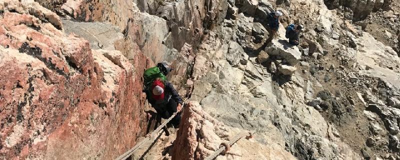
Climbing up the south side of the majestic Grand Teton, this route follows the Lower Exum and the Upper Exum on the Full Exum Route. The Lower Exum Ridge is steeper and more difficult than the upper and is a great course for climbers seeking good difficult rock on the Grand Teton. The first pitch of the Lower Exum ridge is a straightforward chimney. Chimney up for a while, tunnel through a chockstone and then you can bypass the second crux where the chimney closes up. The second pitch ascends some ramps and corners up to another large ledge. Pitch 3 ascends a nice jam crack to some black rock. With a 60 meter rope this easily links with pitch 4, which ascends an interesting 5.7 chimney. Pitch 4 chimney is in two parts, starting with the crux of the lower part to get into the chimney, after which it was straightforward and this leads into a wider chimney that is capped with a large chockstone. Next is the famous Black Face pitch that leads to Upper Exum Ridge, one of the most popular routes to the summit. With the combination of ready access, southern exposure and exciting climbing with excellent rock, the Upper Exum route will continue to be popular.
Wyoming, Jackson Hole
18 :54 hrs
6.7 mi
1950.6953 ft
II
Grand Teton is the highest mountain in Grand Teton National Park and a classic destination in American mountaineering. The Owen-Spalding route begins at the Lower Saddle between the Grand and Middle Teton peaks. Scrambling and sections of modest difficulty climbing lead to the Upper Saddle between The Enclosure to the west and the west wall of Grand Teton to the east. From the Upper Saddle ropes can be used to traverse exposed 2,000 ft cliffs along the west flank, but the section is generally considered non-technical. Features such as the "Belly Roll" and "The Crawl", where climbers usually straddle a rock fin for several yards, lead to the Double Chimney. The chimneys are the most complex section of the climb and may be icy. This section leads to a steep scramble to the summit. The descent may be down-climbed or rappeled using several fixed anchors.
Wyoming, Albany County
02 :47 hrs
1.7 mi
381.30273 ft
Hard
There are three major routes leading to Medicine Bow Peak. This one begins at the Lewis Lake Trailhead and it is the most aggressive but also the shortest route of the three. It is a relatively short and beautiful hike, but also has some the exposure and dangers of alpine mountain exploring. Thunderstorms, lightning, and even snow can occur at any time of year.
Wyoming, Teton County
00 :15 hrs
0.6 mi
18.522217 ft
Easy
Loop featuring the Turquoise Pool, Opal Pool, Grand Prismatic Spring, and Excelsior Geyser. Each season offers a unique experience.
Wyoming, Teton County
00 :14 hrs
0.6 mi
10.789551 ft
Easy
Old Faithful Geyser Loop offers views of the geyser from all directions. The attraction is popular all year and allows a different experience with each season.
Wyoming, Teton County
00 :14 hrs
0.6 mi
8.702148 ft
Unknown
Located north of Old Faithful, this is named for the unusual biscuit-like deposits that surround Sapphire Pool. It is an interpretive trail with geysers, mud pots, hot springs, and wildlife. It also connects to Mystic Falls, Fairy Creek, and Summit Lake.
Wyoming, Crook County
01 :05 hrs
2.8 mi
89.46289 ft
Moderate
This is the longer of two loops which includes the Southside Trail and the Red Beds trail. You can also include the Valley View section which would add almost a mile. The Devils Tower is a one-of-a-kind monolithic feature that was the first to become a national monument. There is a fee charged upon entering the monument area.
Wyoming, Jackson Hole
05 :44 hrs
5 mi
374.55322 ft
Expert
This route will take you past the beautiful Phelps Lake and into a portion of Death Canyon. It is an option to continue in the canyon as a multi day adventure but the route is plotted as a day hike out and back. Use necessary precaution in winter for avalanche safety and awareness.
Wyoming, Jackson Hole
02 :16 hrs
2.9 mi
120.79663 ft
Moderate
Start at the Jenny Lake Ranger Station and head west following a paved trail. The paved trail eventually disappears to become a dirt, easy-to-follow trail all the way to Hidden Falls and Inspiration Point. When you arrive at the boat harbor, follow signs and trails to Hidden Falls as you pass over bridges and thundering cascades.
Wyoming, Jackson Hole
04 :54 hrs
3.5 mi
687.83765 ft
Expert
The hidden gem of the Tetons. Mineral deposits give this lake its beautiful turquoise color.From the Lupine Meadows trail head follow the same path to Amphitheater Lake. At mile 2 is a sign to turn right towards Amphitheater Lake.Important: At the first switch-back turn on the Amphitheater Lake trail you must continue straight. The trail is not well traveled and you might think it isn't even a trail. The trail becomes more visible and is littered with cairns. The final approach is a scramble up a moraine. Be careful of slippery and loose rock up this steep rock field. There is no obvious trail in the moraine, so you must look for the cairns. Camp spots and picnic areas surround the lake. The massive peak you will be staring at is a rare vantage point of the Grand Teton. Enjoy
Wyoming, Yellowstone National Park
00 :36 hrs
0.3 mi
105.829346 ft
Moderate
Most of this trail is a steel staircase and is quite steep down into the Grand Canyon of Yellowstone. There is a lookout point at the bottom with unmatched views of the canyon.
Wyoming, Yellowstone National Park
03 :58 hrs
2.3 mi
633.18823 ft
Hard
Located just inside the east entrance to Yellowstone National Park from Cody, Wyoming, avalanche peak rises above the timberline. The hike begins at picnic area on the west end of Eleanor Lake. You will likely encounter snow and wind at the higher elevations.
Wyoming, Jackson Hole
12 :20 hrs
6.7 mi
1815.8047 ft
Extreme
This hike begins at Lupine Meadows and follows the south fork of Garnet Canyon. Getting lost in the upper Tetons is not difficult. Avoid getting lost by climbing all the way to the saddle between the South and Middle Teton. Once at the saddle take the largest most obvious couloir heading to the summit. In the early season and early hours of the day crampons may be useful on the harder snow. Take a climbing helmet as this route is popular and subject to falling rock. Be careful and mindful of climbing parties above and below you. Note: The north (left) summit is the highest on the Middle Teton.
Wyoming, Platte County
00 :29 hrs
1.1 mi
3.4208984 ft
I
Glendo Reservoir is one of the most popular lakes in Southern Wyoming. This is a hand launch area that is calm and beautiful located on the southwestern side. Camping is also allowed.
Wyoming, Teton County
00 :36 hrs
1.6 mi
12.446533 ft
Easy
This loop only covers a small amount of what there is to see in the Upper Geyser Basin, and it covers quite a bit. This is probably the most visited area in Yellowstone and it is not to be missed. There are many variations and spur trails off of this plotted route, but the route itself will show you an immense amount of thermal features.
Wyoming, Jackson Hole
11 :54 hrs
6.7 mi
1730.6958 ft
Extreme
Start at the Garnet Canyon trailhead. The South and Middle Tetons share the same trail until it splits at the saddle between the two peaks. This hike is often done as a two-for-one as the two peaks are close together.Snow/glacial travel may exist even in the summer months. You may want to bring a mountaineering ax and rope for any snow travel you will encounter.
Wyoming, Jackson Hole
07 :44 hrs
2.2 mi
1613.2864 ft
Extreme
From Lupine Meadows head west (the main trail head for Amphitheater Lake and The Grand Teton is at the south end of the parking lot) on the most direct route toward Teewinot. The trail is not well maintained and route finding skills are essential on this hike. Ice axes will be utilized in early season (June and July). From the apex of Teewinot you will have spectacular views of The Grand Teton's north face and Mt. Owen. This hike is usually done in one day.
Wyoming, Alta
07 :23 hrs
3.8 mi
1236.1206 ft
Expert
Table Mountain is a great introduction to the Grand Teton area as well as a great way to get a good look at the west side of the Grand Teton itself. This route is fairly steep and direct so take it slow if you need to.
Wyoming, Jackson Hole
10 :38 hrs
5.9 mi
1584.177 ft
Extreme
The rounded summit of Cloudveil dome is a popular hike because of its ease in comparison with other Garnet Canyon Hikes. It also allows you to see many of the Garnet summits.Begin at Lupine Meadows and head to the south fork of Garnet Canyon. Camping at the Meadows (with a back country permit) makes the summit bid easier and shorter. From the south fork head to the col between Cloudveil and Nez Perce and traverse the ridge following the climber's trail. There is one exposed move (5.1) a few hundred meters before the summit. Once you move up and over the detached flake of rock head right (east) and head up the summit.Early season hiking may be recommended to bypass the talus and scree fields by crossing snow fields. You will need Crampons and ice axes for early season snow travel.
Wyoming, Yellowstone National Park
01 :33 hrs
1.3 mi
190.50366 ft
Moderate
This is a seldom visited thermal feature that is well worth the hike. The unique Monument Geyser is just one of the many features in this area. Be careful not to damage any fragile crusts or formations. Parking may be limited but it is a pullout just south of the bridge over the Gibbon River.
Wyoming, Yellowstone National Park
04 :08 hrs
3.5 mi
419.2798 ft
Expert
This is what is left of the old volcano on the north end of Yellowstone's giant caldera. This trail is actually a seldom used service road which makes for a nice wide, flat hiking surface. Mount Washburn is known for it's showcase of wildflowers and spectacular views.
Wyoming, Teton County
06 :36 hrs
7 mi
214.40051 ft
Extreme
The hike to this waterfall is best done as a day hike. The falls themselves are some of Yellowstone's most majestic. The trail begins on the Ashton Flagg road right at the Grassy lake reservoir. As you are nearing the falls on Mountain Ash Creek trail you'll notice a spur to the left - this is called North Fork Trail and leads to a naturally heated swimming hole called Scout Pool. High clearance and or four wheel drive recommended to reach the trailhead.
Wyoming, Jackson Hole
00 :57 hrs
2.7 mi
57.38257 ft
III
The run down the lower Gros Ventre River is a short but scenic stretch for advanced paddlers looking for a challenge. This steep run starts from the bridge located at the outlet of Lower Slide Lake and continues through boulder gardens with twists and turns creating continuous class III to class IV rapids. The difficulty of the rapids varies due to current water flow so scouting the river before is advised. The take-out is located just before the boundary for Teton National Park and it is important to make the take-out spot as boating within park boundaries is not allowed.
Wyoming, Jackson Hole
02 :29 hrs
5.5 mi
4.624756 ft
I
Located in Grand Teton National Park, this small lake offers dramatic scenery including some close-up views of the Tetons. The lake is also known for great fishing and wildlife viewing. Visitors can also enjoy the lodge, a visitor center, campgrounds, and hiking trails. The winds can pick up on the lake causing waves to develop so paddlers should pay close attention to the weather while on the lake.
Wyoming, Washakie County
00 :21 hrs
0.4 mi
66.45288 ft
Unknown
Ten Sleep Canyon is one one of the most amazing sport climbing areas anywhere. The quality of the Limestone is as good as it get's in the U.S. The area is new so the routes are not polished and the friction is amazing in cooler temperatures. Ten Sleep is a destination spot that sports more 5.14+ potential than any other spot in the U.S. so don't be surprised to see world famous climbing roping up next to you.
Wyoming, Lincoln County
00 :57 hrs
2.6 mi
43.705933 ft
IV
The Greys River runs north through a beautiful forested valley situated between the Wyoming Range on the east and Salt River Range on the west. This steep section of river starting at Squaw Creek Campground is for advanced paddlers with many class III to class IV rapids that run through stretches of boulders and narrow canyon sections of the river. Scouting this section of the river beforehand is strongly advised. The river calms significantly at the take-out at Bridge Campground.
Wyoming, Sublette County
04 :51 hrs
5.5 mi
189.96167 ft
Expert
This route begins at the Big Sandy Lake Trailhead and takes you out to Big Sandy Lake and also the junction with the Continental Divide Trail. It is set up as an out and back but the Big Sandy Trailhead is the starting point for many backcountry adventures in the Wind River Range. A free permit is required for large groups or for multi-day trips into this area.
Wyoming, Sweetwater County
11 :07 hrs
27.8 mi
2.0421143 ft
SK I
Flaming Gorge National Recreation Area is located in southwest Wyoming and northeast Utah and offers abundant opportunity for water recreation. There are four boat ramps located in Wyoming allowing paddlers access to many different parts of the lake. The lake is made up of many channels and canyons for visitors to explore. The Firehole Canyon launch is located on the northeast side of the lake and offers a boat launch, restrooms, picnic sites, and campgrounds. Flaming Gorge is popular for many water sports and there are larger boats on the lake including houseboats so it is important to pay attention to other boaters while on the lake. Open water crossings may be necessary depending on the route being traveled.
Wyoming, Hot Springs County
03 :09 hrs
7.5 mi
26.687012 ft
I
Put in just above Thermopolis and take out in Thermopolis.
Wyoming, Teton County
00 :10 hrs
0.5 mi
5.6621094 ft
Unknown
This scenic forest service campground is located east of Driggs Idaho up the scenic Teton Canyon Road. The campground is next to popular trails for hiking, backpacking, and horseback riding. The campground offers 20 single sites and 2 double sites. Most sites can accommodate equipment up to 20 feet in length but there are a few that can accommodate larger units. All sites have picnic tables and fire pits. Drinking water and vault toilets are also available. The sites are $12 a night for single and $24 for double. Sites can be reserved online or will be available on a first-come, first-serve basis if available.
Wyoming, Jackson Hole
11 :49 hrs
6.7 mi
1821.4985 ft
S3+
The Middle Teton has had more ski descents from its summit than any other Teton peak and is probably the most skied in the entire Teton Range. This is the most popular route to the summit and the most popular ski descent. This hike begins at Lupine Meadows and follows the south fork of Garnet Canyon to the saddle between the South and Middle Teton. Once at the saddle take the largest most obvious couloir heading to the summit. If the route is taken in the winter, roads to the trailhead will be closed. If this is the case, begin the route in the city of Moose.
Wyoming, Yellowstone National Park
06 :29 hrs
17.3 mi
355.57996 ft
Hard
Begin at Hellroaring Trailhead and go to Gardiner for a almost entire down-hill hike (you will want to set up a shuttle vehicle).Easy, downhill hiking plus great campsites make this backpacking trip a classic. Great scenery and wildlife on top of some of the best fishing in the park add to popularity of this hike.You will cross from Wyoming to Montana. Get a fishing license for the park and you shouldn't have any trouble with interstate fishing.Most people do this hike in 3 days. However, a 4 day trip is enjoyable with many campsite along the way.Snow usually melts early in this area giving you the chance to do some rare back country hiking early in the season.
Wyoming, Yellowstone National Park
00 :08 hrs
0.5 mi
78.437744 ft
Moderate
The view of Tower Falls from below is one you don't want to miss. A short hike with a great reward. Shortly after the hike begins you'll get a great perspective of the falls, then follow the trail to end up right beneath them.
Wyoming, Yellowstone National Park
01 :32 hrs
1.6 mi
120.43701 ft
Easy
There are stunning views all along this walk. Use caution with small children because of steep areas along the way. If you continue beyond the route specified you will reach the Specimen Ridge Trail. Watch for bighorn sheep as well but do not approach any wildlife within the park.
Wyoming, Yellowstone National Park
01 :40 hrs
1.8 mi
27.785645 ft
Easy
This trail follows the south rim of the Yellowstone River. It is plotted as out to Artist Point and back, but you can choose whatever distance you want to cover. The trail also passes by the Uncle Toms trailhead where you can descend the metal stairs into the Grand Canyon of the Yellowstone.
Montana, Yellowstone National Park
06 :54 hrs
4.3 mi
942.6892 ft
Extreme
Ascending Yellowstone's Electric Peak is said to be the most spectacular hike in the Park, but is also very difficult and long. This route picks up at the Cache Lake Junction which is 3.7 miles from the Glen Creek Trail-head. The climb to Electric Peak can be done in a single day but is recommended to be part of a 2 or 3 day camping trip. Backpackers must have a backcountry permit to stay overnight.
Wyoming, Yellowstone National Park
01 :39 hrs
1.5 mi
70.80762 ft
Moderate
Amazing views along the North Rim of the Yellowstone River. Walk past the brink of the Upper Falls, Crystal Falls, and Lower Falls arriving to the North Rim road where you can arrange a ride or return to your vehicle.
Wyoming, Teton County
02 :24 hrs
3.1 mi
23.6792 ft
Hard
A well maintained, well traveled trail to a beautiful waterfall nearly 200ft high. After getting a good look at Fairy Falls, go ahead and follow the trail out to a spectacular geothermal area with the colorful Imperial Geyser.
Wyoming, Jackson Hole
08 :14 hrs
3.8 mi
1427.8625 ft
Extreme
Located just below the Grand Teton, Disappointment Peak is named as such when climbers in 1925 were attempting to climb the Grand, but found an impasse on this peak where a 450 foot drop is encountered to the saddle between the two summits. This route is a great hike that can be done without any technical gear in the summer months. The route hikes through Lupine Meadows and then follows the Valley Trail for and the well-maintained Amphitheater Lake trail. Be aware to go around the left of both Surprise Lake and Amphitheater Lake and then just after Amphitheater, turn to ascend the ridge to the summit. Amazing views of the Tetons are seen along the hike, and from the summit, the view is just below the Grand and is remarkable.
Wyoming, Teton County
02 :33 hrs
3.4 mi
18.131348 ft
Expert
The trail from Sentinel Meadows Trailhead takes you out to a thermal area known as the Queens Laundry, and a little bit beyond where there is backcountry camping available. You're likely to come across some muddy feet so plan accordingly. Also, Bison are plentiful in this area so give them plenty of space which is good for both of you.
Wyoming, Jackson Hole
09 :24 hrs
18.7 mi
1180.635 ft
Expert
This loop, which begins and ends at String Lake trail head, is a popular hike for a good reason. Views of peaks, streams, waterfalls, lakes, and wildflowers abound on this hike.It can be done in one strenuous day or make it a two-day trip by spending the night at Lake Solitude (back country permit required if you spend the night).
Wyoming, Yellowstone National Park
05 :29 hrs
5 mi
420.54053 ft
Expert
Named so because it used to be seven miles down into the hole, this trail descends down into the "grand canyon of Yellowstone". Bring plenty of water for the climb back out since there aren't any water sources down there, and the return trip can be difficult.
Wyoming, Jackson Hole
10 :13 hrs
5.2 mi
1642.8555 ft
Extreme
Teewinot (Shoshone for “pinnacles”) can be approached by many variations and route finding skills are essential for this climb. It usually done in one arduous push (many will begin their hike shortly after midnight) but can be done as a two day hike with a back country permit. See the Jenny Lake Ranger Station for availability and recommended camp sites.Begin at Lupine Meadows and follow the trail to Delta Lake. After Delta Lake head toward the Teton Glacier, once on the glacier look for your couloir to the north. Be careful that you choose the correct couloir and be prepared to scramble to reach the plateau/saddle below the summit. The apex of Teewinot is large enough for only one person at a time and offers spectacular views of the north face of The Grand Teton and Mt. Owen.Early season (June and July) will require ice axe and mountaineering skills.
Wyoming, Sublette County
15 :57 hrs
16.4 mi
733.833 ft
Extreme
A popular introduction to the Wind River Range. There are places to camp and choose other hikes with Summit lake as your base camp, or even camp along the Green River somewhere as a shorter option. Beautiful hike along the river without much elevation gain until you leave the river for the switchbacks up to the lake.
Wyoming, Sublette County
06 :54 hrs
6.2 mi
598.39575 ft
Extreme
This out and back hike could be done in one day or perhaps better enjoyed by staying overnight. There are many lakes to be seen in the Wind River Range, and these are some real beauties.
Wyoming, Jackson Hole
10 :11 hrs
5.7 mi
1539.1697 ft
Extreme
Begin at the Garnet Canyon trailhead and go to the Platforms (if you are doing a two day climb then the Platforms are an optimal camp site, with a backcountry permit). From the Platforms head toward the col between Nez Perce and Cloudveil Dome, but don't go all the way to the col. Find the couloir and begin your summit approach from the couloir.Early season can be a preferable time for Nez Perce because you can walk over loose talus on snow and skip that arduous process.The Northwest Couloirs are the easiest approach to Nez Perce and doesn't require 5th class climbing skills; however, you will want to be familiar with snow travel, rope work, and rappelling.The view from Nez Perce is spectacular as you can see all of the Garnet Canyon summits and the valley summits to the south.
Wyoming, Sublette County
07 :00 hrs
14.6 mi
384.74487 ft
Extreme
One of the most well known hikes in the Wind River Range, and for good reason. The views from within the Titcomb Basin are hard to beat. This route will take you into the basin lakes and should be done as an entry or part of an extended overnight backpacking trip. Biting flies and Mosquitos can be annoying in July, but earlier or later in the summer they aren't as bad. Due to the popularity of the trail, you will most likely encounter other hikers.
Wyoming, Fremont County
02 :43 hrs
2.3 mi
263.4082 ft
Hard
One of the most popular and most rewarding day hikes in the Wind River Range. Lake Louise is known for good fishing and great views. It can also be done as an easy overnighter.
Wyoming, Albany County
04 :29 hrs
10.4 mi
126.65405 ft
Expert
Not only does this trail take you past sheep lake, it is a grand tour of the lakes of the Snowy Range of the Medicine Bow Wilderness. This area is considered one of Wyoming's best kept secrets. There are options to spur off of this trail such as at mile 3.75 you may choose to go north to sand lake for a shuttle hike.
Wyoming, Jackson Hole
04 :02 hrs
9 mi
1.083252 ft
I
This glacial lake is another great opportunity for visitors of Grand Teton National Park to take in the dramatic scenery the park has to offer. Leigh Lake displays great views of the Teton range and offers a backcountry feel as the lake can only be accessed by paddlers and hikers. Paddlers will use the boat launch at String Lake and travel north to the end where the water narrows out and a short portage is required. The portage trail is located on the east side and follows a wide trail before arriving at log steps that lead down to Leigh Lake. For paddlers looking for a multi-day trip there are designated camp sites available for use and great hiking trails around the lake.
Wyoming, Jackson Hole
05 :25 hrs
6 mi
3.699463 ft
I
Jackson Lake is a scenic destination that provides visitors with amazing views of the Teton Range. This trail leads paddlers north along the shores of the lake up to Sargents Bay. Paddlers will want to stay close to the shoreline as this section of lake is more exposed to wind and rough waters. There are bays and inlets along the route providing paddlers with calmer waters for exploration. Jackson Lake also provides great wildlife viewing and fishing opportunities.
Wyoming, Jackson Hole
01 :23 hrs
3.1 mi
0.22973633 ft
I
This small lake located between Jenny Lake and Leigh Lake is positioned right below the Tetons and offers exceptional views. The lakes clear calm waters are perfect for paddlers of all levels. The water is also shallow and warmer than the surrounding lakes making it a great spot for swimming. The lake is surrounded by thick forests providing lots of opportunity for birdwatching and viewing wildlife.
Wyoming, Sublette County
04 :00 hrs
4.5 mi
21.898926 ft
I
The Green River Lakes are located in the northern Wind River mountains and offer breathtaking scenery and solitude for paddlers wanting to explore the area. Paddlers will launch from the upper lake and travel to the end of the lake and proceed through a connecting channel to the lower lake. It can be challenging paddling through the channel so it may be necessary to get out and walk the banks of the channel pulling the boat with a rope until reaching the lower lake. The trail then continues to the end of the lower lake where paddlers will be rewarded with impressive reflections and views of Squaretop Mountain. Paddlers can stop at the end of the lake or continue up the main channel for more mileage if up for the challenge. The winds can pick up on the lakes creating rough waters so be mindful of current weather conditions before setting out.
Wyoming, Jackson Hole
04 :10 hrs
9.8 mi
10.999512 ft
II
This section of the Snake River is a great option for more intermediate and advanced paddlers as there are sections that require route-finding and more aggressive paddling. There may also be areas of small islands, gravel bars, boulder fields, and debris that will require skillful navigation. The last 4 miles of the route follow the shores of Jackson Lake to the take-out at Lizard Creek Campground. Wind and rough waters can arise on Jackson Lake so paddling close to shore for protection is advised.
Wyoming, Jackson Hole
03 :37 hrs
9.7 mi
25.83374 ft
Expert
This epic hike, that begins near the Colter Bay Visitor Center, takes you along a potentially disorienting maze of trails. It can be hiked as an extension of the Swan Lake and Heron Pond Hikes. Beautiful mountain, lake, and lily pond vistas surround the entire hike. This hike intersects with several different hikes which leaves you many options on how you will make your loop
Wyoming, Sublette County
02 :03 hrs
4.6 mi
21.637451 ft
I
The Lower Green River Lake is the first of the two Green River Lakes located in the northern Wind River mountain range. The area is popular due to the stunning scenery and accessibility by car. Paddlers will put-in at a small launch site near the campground and travel around the lake for a scenic trip including views of Squaretop Mountain. For paddlers looking to explore more territory, non-motorized boats can proceed through a river channel onto the upper lake and explore that area as well.
Wyoming, Jackson Hole
02 :33 hrs
5.7 mi
7.6835938 ft
I
This section of the Snake River is a great spot for paddlers of all levels. The waters are clear and calm and there are few obstacles to navigate around. Paddlers put-in right below the dam and paddle down the Snake River with a side trip through Oxbow Bend. Oxbow Bend provides lots of opportunity for birdwatching and the views of the Tetons along this stretch are impressive. The current at Pacific Creek landing picks up substantially so it is advised to take out a little upstream before reaching the actual landing.
Wyoming, Jackson Hole
09 :24 hrs
21.3 mi
1139.2063 ft
Extreme
This epic multi-day hike begins (or ends) at the Granite Canyon trail head. This trail can take any time between 2-5 days, depending on how many stops you want to take. A good campsite for the first night is Marion Lake. If you’re taking your time you can stop at one of the many lakes along the trail. For a 3 day trip, your 2nd night could be at the top of Cascade Canyon which will eventually take you down to Inspiration Point and Jenny Lake. The $7 boat ride from the base of Inspiration Point and the bank of Jenny Lake may sound like a bargain to shave off the last mile or so of your long hike.Note: Shuttle a vehicle to your end point (Jenny Lake parking lot). You need a back-country permit to stay over night in the Grand Teton National Park back-country.Take bear sprayTake a WAG BAG—much of the hike is above the tree line so you’ll need to pack out your waste.
Wyoming, Sublette County
08 :31 hrs
8.9 mi
310.6023 ft
Extreme
One of the most popular hikes in the Wind River Range. This trail passes many mountain lakes and incredible views. Many people use this route to access the Titcomb Basin.
Wyoming, Jackson Hole
04 :10 hrs
10.2 mi
51.68811 ft
II
This stretch of the Snake River is a challenging route that requires more advanced paddling skills. The river drops steadily along this portion of river creating stronger currents and many channels and braids with logjams that require careful navigation and route finding. The trip is very worthwhile as paddlers are rewarded with dramatic views of the Tetons as well abundant wildlife viewing opportunities. Scouting the route and checking water flow information is advised before setting out on the river.
Wyoming, Jackson Hole
02 :56 hrs
3.3 mi
1.0153809 ft
I
Paddlers will enjoy views of the Teton Range as they paddle out to the second largest island on Jackson Lake. This trip travels to Donoho Point and then continues on to Hermitage Point where sandy beaches provide a great spot to pull up the boat and enjoy the area. There are great opportunities for fishing and birdwatching while on the lake. Afternoon winds can cause rough waters so be cautious when crossing open waters.
Wyoming, Jackson Hole
06 :59 hrs
15.5 mi
0.98657227 ft
I
This trip travels past the second largest island in Jackson lake before it arrives at Elk Island, the largest island on Jackson Lake. The route will travel around Elk Island providing paddlers with views of the Teton Range while paddling both open waters and protected shoreline. The island is inhabited by lots of waterfowl and wildlife for viewing. Winds and waves are common on the lake so be cautious and avoid crossing open waters during these times when possible.
Wyoming, Teton County
01 :12 hrs
3 mi
21.784424 ft
III
This section of the Snake River is a steep narrow route that is short but offers worthwhile whitewater rapids for more advanced paddlers. Paddlers will put-in at the launch located at the south entrance of Yellowstone and follow the canyon until Flagg Ranch so shuttling of vehicles is required. High spring water flows can effect water levels and the safety of the river so scouting the route beforehand is advised. Canoeing this section of the Snake River should only be attempted by advanced paddlers when water flows are not too high.
Wyoming, Jackson Hole
04 :48 hrs
11.6 mi
35.50879 ft
II
Paddling this section of the Snake River is challenging due to its twists and braids requiring route-finding as well as sections of moderate rapids. There may also be log jams along the route that require careful navigation. The trip offers excellent views of the Teton range and plenty of opportunity for wildlife viewing. Shuttling of vehicles is required between Pacific Creek Landing and Deadman's Bar. Checking current water flow information and scouting the route before setting out is advised to ensure safe paddling conditions.
Wyoming, Teton County
02 :42 hrs
3 mi
0.72021484 ft
I
This section of the Yellowstone Lake shoreline provides paddlers with numerous opportunities to view the thermal activity of the Yellowstone region. The route travels along the West Thumb Geyser Basin where multiple hot springs and geysers can be viewed from the water. Paddlers can then paddle even further to Potts Hot Spring Basin, another less-visited area of geysers and hot springs. Shore access to the hot springs and geysers is not allowed. There are also areas along the route where fishing is not allowed. Afternoon winds on the lake can cause rough waters so leaving early in the day and staying close to the shore is strongly advised.
Wyoming, Yellowstone National Park
06 :36 hrs
7.3 mi
1.6813965 ft
I
Leaving from Sedge Bay and heading south, paddlers follow the eastern shoreline of scenic Yellowstone Lake. Tree-lined shores and rock cliffs along this stretch of the lake provide great scenery and wildlife viewing opportunity. For paddlers wishing to cover the whole distance from Sedge bay down to Meadow Creek an overnight stay is recommended as afternoon winds create rough waters for paddling long distances. There are multiple campsites along this route for overnight use.
Wyoming, Teton County
10 :31 hrs
11.7 mi
4.118408 ft
I
For those wanting a backcountry experience, this route is a great option as it leads into Shoshone Lake, a large remote lake that provides scenic views and solitude. Paddlers will travel up the Lewis River Channel until the current becomes too strong and the river may be too shallow to continue paddling. At this point pulling or lining the boat for a mile or so is required. Having the correct rope, gear, and attire is important during this part of the trek. This section can be very demanding depending on current water levels so check with the backcountry office before setting out. Once the pulling section of the river channel is over, the river then settles out and Shoshone Lake will be in view. Paddlers then continue on to Shoshone Lake. There are many reservable campsites located on the south shore of the lake that can be reserved for overnight stay. The trip back down the channel to Lewis Lake is an enjoyable float that requires little paddling. Watch for any obstacles to navigate around including other paddlers pulling boats up the river channel.
Wyoming, Yellowstone National Park
10 :20 hrs
11.5 mi
1.3999023 ft
I
This trip follows the south shores of the West Thumb of Yellowstone Lake to a protected bay at Wolf Point. This trip is best done as an overnight trip as afternoon winds can cause unfavorable paddling conditions late in the day and there are multiple campsites available along the route. There are great opportunities for viewing diverse landscapes along this section of the lake as well as abundant wildlife.
Wyoming, Alta
03 :06 hrs
2.3 mi
430.9104 ft
Hard
The parking area is located near Driggs, Idaho at the end of Darby Canyon Road. The route offers a waterfall, a canyon, a cave, a river, and views. The canyon is large drainage on the West slope of the Tetons. The trail is mostly used for hiking, trail running, snowshoeing, and rock climbing.
Wyoming, Teton County
06 :02 hrs
4 mi
860.15845 ft
Expert
The view from Mt. Sheridan is said to be one of the best in Yellowstone National Park. This out and back route from Heart Lake can easily be done in one day, but if done from the south entrance trailhead it would be a lengthy 22 miles. Start this route where the spur comes off of the heart lake trail on the northeast corner of the lake.
Wyoming, Jackson Hole
08 :07 hrs
18 mi
0.50878906 ft
I
Paddlers will enjoy great views of the Teton range and Mount Moran as they paddle along the south end of Jackson Lake. Along the route there are many opportunities for viewing wildlife and scenic landscapes. There are a few sections that require open-water crossings in potentially rough water so knowing the route and paying attention to the weather is important. On the return back from Moran Bay paddlers can either return the way they came or cut down from Moran Bay and follow the southern shoreline back to the boat launch.
Wyoming, Big Horn County
14 :26 hrs
10.5 mi
1227.3506 ft
Extreme
Cloud Peak is the highest point in the Bighorn Mountain Range. Be prepared for rugged terrain with a lot of exposure and high mountain weather. Much of this hike involves stepping across big rocks and scrambling up rocky and snowy slopes without an obvious trail. Due to the length of this adventure, most people camp overnight at Mistymoon Lake, which is also an excellent place to turn around as a shorter version of the cloud peak trail. Scenery is top notch along the whole trail.
Wyoming, Cody
07 :42 hrs
22.8 mi
613.32776 ft
V
The Clarks Fork is a beautiful river that offers a great challenge for only the most advanced and physically capable paddlers. The river offers challenging rapids, multiple falls and pools, lots of portaging, and careful navigation. There are other access sites along the route allowing paddlers to run only certain sections of the river. This section of the river commonly starts at the W-296 Bridge with some immediate class IV and V rapids through a steep canyon requiring a few portages. Paddlers then continue on through another two-mile stretch of some tough rapids and a six-mile section of calm waters before entering The Box. The Box is a very difficult canyon to paddle. The run is full of boulders fields, holes, portages, and sections that require technical climbing skills. The entire trip requires two days and is very physically demanding. Scouting some sections of the river can be done from trails that follow the river but much of the river is in a gorge without good visibility of the river.
Wyoming, Teton County
01 :50 hrs
3.9 mi
242.22461 ft
Moderate
A well maintained trail with a loop option. Settlers believed this mountain was shaped like the back of an elephant. From the viewpoint on top of the Elephants Back, there are great views of Yellowstone Lake, Stevenson Island, and Pelican Valley.
Wyoming, Cody
04 :41 hrs
12.2 mi
159.56006 ft
V
The Clarks Fork is a beautiful river that offers a great challenge for very advanced paddlers. The river offers challenging rapids, multiple falls and pools, lots of portaging, and careful navigation. There are other access sites along the route allowing paddlers to run only certain sections of the river. This sections starts with milder class II and III rapids but provides tougher rapids as it travels through slot canyons and a sharp S turn. Portaging multiple sections of this river is usually required.
Wyoming, Jackson Hole
09 :21 hrs
10.1 mi
549.68506 ft
Extreme
Recommended for experienced hikers, this trail will get you deep into the Teton Wilderness along Pilgrim Creek. Thick forest, abundant wildlife, and remote wilderness are all part of this adventure. This is bear country and potentially dangerous backcountry. The route will take you out to Wildcat Ridge and you'll also have the option to venture out to Wildcat Peak. Be prepared for many creek crossings.
Wyoming, Yellowstone National Park
00 :30 hrs
0.6 mi
17.174316 ft
Moderate
A very popular walk along the Gardner River to a naturally heated river and small pools. Due to the popularity of this trail the park service has time regulations for hiking and swimming. Be sure to check and obey current regulations. No pets, no bicycles, no nudity.
Wyoming, Yellowstone National Park
04 :17 hrs
3.8 mi
256.83997 ft
Expert
Walk a scenic dirt road until steep switchbacks lower you down into "sheepeater canyon". Once down there enjoy the view of the majestic Osprey Falls. Osprey Falls are more than 150 feet high. Be prepared for a steep descent and steep climb back out on these narrow switchbacks.
Wyoming, Sublette County
01 :48 hrs
18.7 mi
567.8911 ft
3
Nice loop from Bondurant for the side x sides
Wyoming, Big Horn County
05 :51 hrs
4.2 mi
256.6438 ft
Expert
A challenging route along Hwy 14, this ski follows Road 264 up and then along the rolling hills above Shell Canyon. The views are amazing and the wildlife abundant on this out and back route. This route does require a good snow year as portions are south facing and can get a layer of crust. There is occasional snowmobile traffic.
Wyoming, Jackson Hole
01 :55 hrs
1.8 mi
203.39868 ft
Hard
This steep, short hike will reward you with one of the best views of the Grand Teton and surrounding peaks that Jackson Hole has to offer. This point offers great views of Two Ocean Lake and a sweeping 360 degree view of the Teton Wilderness
Wyoming, Washakie County
00 :35 hrs
0.6 mi
143.4414 ft
Various
The Slavery wall is the largest wall in the Mondo section of Ten Sleep. Aesthetically the roof looks amazing and has a great 5.9 that will take you over the roof. Having eight five star climbs should be a clue that this is a must do wall.
Wyoming, Washakie County
00 :33 hrs
0.6 mi
145.47656 ft
Various
The Vietnam wall is shaded by trees and is nice in mid summer. The route that is a must do on this wall is Bikini Girls With Machine Guns!
Wyoming, Natrona County
00 :01 hrs
0.1 mi
13.645142 ft
Various
A beautiful canyon with pink Precambrian granite wall and every variety of cracks you can imagine. Most of the wall will be 80-120 feet with a few areas like the Power Tower area that has 400 foot walls. This is a committing climbing area if you decide to rap down into the climbs. You can toprope most since your setting up anchors at the top which is a great way to give a climb a try before you commit to the rappel and pulling your rope. The Platte river runs through and is controlled by the Pathfinder dam just up river. A few times per year they will let out enough water to cover the first five feet or so of some of the lower climbs. The water will go down in a week or two and there are always higher climbs to climb. 6 Hours from Salt lake City or 5 hours from Boulder. Check out Sloan's Country store for showers and to refill your water.
Wyoming, Washakie County
00 :32 hrs
0.6 mi
129.42456 ft
Various
The Rust Cage wall offer short climbs with amazing pockets. Mostly vertical up to a bulge and the wall starts to slab out.
Wyoming, Natrona County
00 :02 hrs
0.1 mi
26.315674 ft
Various
This wall is directly below the handrail on the overlook. Rap from the rails or set up anchors just above the wall.
Wyoming, Teton County
06 :41 hrs
10.8 mi
1244.724 ft
Hard
Challenging hike at Jackson Hole. Up and back wildflower-cirque trails.
Wyoming, Yellowstone National Park
02 :06 hrs
1.9 mi
180.8667 ft
Moderate
A well maintained trail to a sturdy suspension bridge that crosses the Yellowstone River. This trail also works well as a beginning to several long distance backpacking treks at Yellowstone.
Wyoming, Cody
03 :31 hrs
7.9 mi
289.261 ft
Hard
This loop will get you views of a few of the many lakes in the Beartooth Mountains. Be prepared for several stream crossings and mosquitos are likely to be abundant. Plenty of opportunities to explore along the way.
Wyoming, Yellowstone National Park
00 :25 hrs
1.1 mi
23.601807 ft
Moderate
A popular hike with a loop around the Artist's Paint Pots which are some incredible geothermal features. It's a short walk on a trail that is partly boardwalk. Please remember that thermal features are fragile and can easily be damaged by objects thrown into them. Pleas help preserve Yellowstone National Park.
Wyoming, Teton County
01 :53 hrs
2.5 mi
18.4375 ft
Hard
Hike along the old paved service road to one of Yellowstone's popular Geysers. The Geyser erupts every two or three hours and can reach 50ft high during eruptions which last about 15 minutes.
Wyoming, Jackson Hole
17 :50 hrs
6.7 mi
1821.4985 ft
II
This hike begins at Lupine Meadows and follows the south fork of Garnet Canyon. Getting lost in the upper Tetons is not difficult. Avoid getting lost by climbing all the way to the saddle between the South and Middle Teton. Once at the saddle take the largest most obvious couloir heading to the summit. In the early season and early hours of the day crampons may be useful on the harder snow. Take a climbing helmet as this route is popular and subject to falling rock. Be careful and mindful of climbing parties above and below you. Climbing equipment may be necessary in snow and ice conditions.
Wyoming, Yellowstone National Park
00 :24 hrs
0.5 mi
17.955444 ft
Easy
A very short walk with little elevation gain will get you within view of Yellowstone's Wraith Falls. The Wraith Falls pullout is on the south side of the Grand Loop road, about 5 miles southeast of Mammoth.
Wyoming, Jackson Hole
03 :44 hrs
3 mi
426.87915 ft
Moderate
Goodwin Lake is a great, family friendly hike. The moderate incline and beautiful vistas make this a local favorite. Panoramic views of the Tetons are unmatched from the Goodwin Lake trail head. The hike starts out moderately steep and levels out for the majority of the hike. As you approach the lake the terrain will change slightly and become rocky as you travel the base of Jackson Peak. Make your way through the maze of fallen pines and micro-creeks and you will soon arrive at the breath-taking Goodwin Lake. Perfect picnic areas abound on the banks of the lake and it doesn't take much luck to catch a good size trout as the lake isn't heavily fished.Note: Consider wearing long sleeves and pants as the horse flies can be an issue.
Wyoming, Fremont County
01 :23 hrs
13.8 mi
777.50476 ft
Moderate
A rugged canyon at the base of the southern Wind River Mountains, Sinks Canyon named such because the river vanishes underground near the mouth of the canyon. This ride is a loop from Sinks Canyon State Park and climbs up numerous switchbacks to the top of Lander Mountain. The view from the mountain, overlooks into the canyon and is phenomenal. The road then gradually descends back into the canyon to complete the loop. A very small section of this ride is on a packed dirt road.
Wyoming, Fremont County
01 :03 hrs
1.7 mi
199.65161 ft
Moderate
It's a short walk along the Popo Agie River and well worth it to go see these falls. The trailhead is also used as access to the Wind Rivers and has many options beyond the falls.
Wyoming, Evanston
15 :11 hrs
30.9 mi
86.60596 ft
III
This portion of the Bear River starts in the Kayak park in Evanston and goes to Woodruff Narrows Reservoir. This is a long adventure and with the river being so flat there will be lots of paddling.
Wyoming, Jackson Hole
11 :45 hrs
3.8 mi
1425.9878 ft
II
Located just below the Grand Teton, Disappointment Peak is named as such when climbers in 1925 were attempting to climb the Grand, but found an impasse on this peak where a 450 foot drop is encountered to the saddle between the two summits. This route is a great hike that can be done without any technical gear in the summer months. The route hikes through Lupine Meadows and then follows the Valley Trail for and the well-maintained Amphitheater Lake trail. Be aware to go around the left of both Surprise Lake and Amphitheater Lake and then just after Amphitheater, turn to ascend the ridge to the summit. Amazing views of the Tetons are seen along the hike, and from the summit, the view is just below the Grand and is remarkable. Equipment is necessary through snow and ice travel.
Wyoming, Fremont County
01 :42 hrs
4.1 mi
152.19849 ft
Moderate
This trail wanders along the Popo Agie River and the Sinks of the state park. It has a loop near the end and returns to the park visitors center. Choose any distance to explore the geological mystery and wonders of the sinks.
Wyoming, Hoback
03 :31 hrs
8.5 mi
29.88794 ft
II
The Snake River along this section offers great scenery, fishing, birdwatching, and some waves and rapids along the way for paddlers to enjoy. Shuttling of vehicles is required between the South Park launch and Astoria Boat Ramp. There is a self-registration fee required for this section of the river that should be available at the boat launch sites.
Wyoming, Sublette County
06 :18 hrs
4.5 mi
726.79297 ft
Expert
This is a well maintained trail to the summit of the highest peak in in the Wyoming Range. At about 2.5 miles the trail has an intersection where the trail on the left will lead you to the lower Wohelo Falls. It is after this intersection that the trail steepens and remains steep until the summit. As usual, with a steep climb comes extraordinary views. This trail intersects with the Wyoming National Recreation Trail and has portions that are mountain bike accessible.
Wyoming, Jackson Hole
02 :22 hrs
6.4 mi
26.073975 ft
Hard
If you are in search for relief from the Teton crowds this loop is a good one. This beautiful lake is isolated and less crowded than its westerly counterparts. You can take the loop in either direction or do an out and back. The north part of the lake offers the better views of the Tetons and surrounding peaks and the pines aren't as thick (the north side out and back will add some length to your hike as it is longer than the south side). If you do the out and back, the north side is recommended. Watch out for bear and moose in this thick forest, and the water foul are usually out during the summer months.
Wyoming, Fremont County
01 :04 hrs
2.4 mi
4.043213 ft
I
Located at the base of Pinnacle Buttes, Brooks Lake offers beautiful scenery including views of the Wind River and Absaroka mountain ranges. The lake is very remote and does not allow motorized boats. There are campsites and a lodge located on the lake and lots of opportunity for other recreation to include hiking and fishing.
Wyoming, Yellowstone National Park
04 :42 hrs
3.5 mi
596.15283 ft
Hard
A great hike through thick pines gaining access to a remote area of Yellowstone's backcountry. This route is out to the pass and back, although you may wan't to continue on the trail that goes north to Repuplic Pass or south to Wahb Springs, which both have campground options along the way.
Wyoming, Yellowstone National Park
00 :25 hrs
0.3 mi
59.8667 ft
Easy
This route is nice because it can be done quickly and offers a variety of attraction. Great fishing for those familiar with the sport, and great opportunity to get out of the car and see a mountain lake on foot. There is also a nice trail around the lake once you're there if you want to circle around it. You will need a park fishing permit to go fishing and be sure it's open season.
Wyoming, Teton County
04 :05 hrs
4.5 mi
13.077148 ft
I
The trail follows the northern shores of Lewis Lake and then proceeds upstream Lewis Channel towards Shoshone Lake for a couple of miles. The water flow increases a few miles up the river so going up further is possible but only for those who are up to the challenge. The channel provides paddlers an opportunity to avoid the rougher waters and wind on Lewis Lake and enjoy a more relaxing float downstream. The area provides great opportunity for birdwatching, viewing wildlife, and fishing. There may be occasional downed trees or debris in the river that paddlers will need to navigate around.
Wyoming, Yellowstone National Park
03 :12 hrs
3.5 mi
0.95996094 ft
I
Sedge Bay is located on the northeast side of Yellowstone Lake and offers paddlers the opportunity to spend time in a more remote part of the lake. This section of lake offers lots of birdwatching opportunities and great scenery as paddlers follow the jagged shoreline of the lake. There is no set distance for this trip so paddlers can choose how many miles to cover. The winds can become strong in the afternoon resulting in rough waters so leaving early in the day is advised.
Wyoming, Teton County
03 :49 hrs
8.5 mi
3.3015137 ft
I
Lewis Lake is the third largest lake in Yellowstone National Park and offers plenty of beautiful scenery and wildlife. The lake travels along sandy shores and heavily forested areas offering views of the Red Mountains and peaks of nearby Grand Teton range. Paddlers may also see steam rising from hot springs at the outlet of the Lewis River channel where paddling is not allowed. The winds can pick up in the afternoon so avoid lake crossings during these times and stay closer to the shoreline to avoid unsafe water conditions.
Wyoming, Jackson Hole
02 :39 hrs
5.9 mi
1.6186523 ft
I
Situated just east of the Jackson Lake area, this small glacial lake contains clear, calm waters ideal for an easy paddling trip in Grand Teton National Park. The lake offers beautiful scenery to include meadows of wildflowers and thick forested areas. There are lots of opportunities for birdwatching and viewing wildlife in the region including an occasional moose or elk sighting. Other activities at the lake include fishing and hiking.
Wyoming, Yellowstone National Park
03 :24 hrs
4.1 mi
47.843506 ft
Expert
This is an adventurous day hike with the option to stay overnight in the campground at the lake. To get to Wrangler Lake you must cross Sour Creek which can be waist deep in the springtime, but is usually much lower. Beware of mosquitoes as usual.
Wyoming, Big Horn County
00 :46 hrs
0.5 mi
127.242676 ft
Moderate
After a little bit of a dirt road drive, this is a short but steep hike down to a beautiful hidden jewel of the Bighorn Mountains. A must see if you're in the area. They say there is still some gold dredging equipment down near the bottom of the falls.
Wyoming, Yellowstone National Park
01 :19 hrs
1.5 mi
36.22339 ft
Moderate
It's a short hike to Clear Lake and back but there are also a few thermal features just passed the lake. This route takes you past the lake and to the junction with the Ribbon Lake trail. From there you can go left and arrive at the deep Yellowstone River and artist point, or you can go right and follow the route for Ribbon Lake, or return to your vehicle at the Uncle Tom trailhead.
Wyoming, Jackson Hole
02 :17 hrs
5.1 mi
7.899414 ft
I
The lake is located just 15 miles from Jackson at the entrance of the Gros Ventre Mountain range. The lake offers calm waters with beautiful scenery. Visitors to the lake can view the site of a major landslide that created the lake in 1925. The area has interesting geological features and colorful rocks that make it a sight to see. The lake also offers fishing, camping, and an interpretive trail with information regarding the historic landslide.
Wyoming, Yellowstone National Park
07 :23 hrs
6.5 mi
419.79102 ft
Extreme
A less popular but more backcountry way to hike down to the Yellowstone River. The trail begins the same as the Specimen Ridge hike, then cuts off to the south at about three miles. Backcountry camping is available once you're down to the Yellowstone River.
Wyoming, Big Horn County
01 :35 hrs
1.9 mi
80.865845 ft
Hard
Explorer Canyon is one of the many amazing canyons at Lake Powell. You must access the canyon by boat. There are many things to see including arches, small cascading waterfalls and petroglyphs. This is a beautiful canyon and well worth a visit.
Wyoming, Yellowstone National Park
04 :22 hrs
4.7 mi
136.55469 ft
Hard
Because of bear management and parking availability, this is the best option of several to hike to Turbid Lake. It will take you out to the lake and back covering a total of almost 10 miles. It begins at 9 mile trailhead which is 9 miles east of Fishing Bridge. Use caution when crossing roadways. Trail is not very often hiked and thus not well maintained.
Wyoming, Jackson Hole
03 :17 hrs
3.4 mi
224.33765 ft
Hard
This hike offers a beautiful view of Jackson Lake and the Tetons. It's one of only a few official National Park Hikes in this section of GTNP. You can drive to the look out point and walk down or you can also make this hike a lollipop loop with a small section that juts out in the lower middle portion of the hike. It is all well marked.
Wyoming, Sublette County
09 :55 hrs
22.1 mi
2.8486328 ft
I
Fremont Lake is the second largest natural lake in Wyoming and offers plenty of opportunity for scenic paddling. The lake is only 4 miles from the town of Pinedale and is surrounded by Bridger-Teton National Forest making it a popular destination for all types of recreation. There are multiple boat launch sites making it convenient to explore different parts of the lake including the many inlets and bays. The lake offers many other recreational activities including fishing, wildlife viewing, sailing, swimming, camping, and a variety of boating activities.
Wyoming, Johnson County
04 :45 hrs
4.1 mi
420.62793 ft
Expert
This hike is steep and rocky but offers great rewards. Camping is available and staying overnight is recommended due to the rugged terrain and altitude gained. You will pass Sherd lake and have options to fish or explore other lakes in the area.
Wyoming, Yellowstone National Park
08 :18 hrs
16.9 mi
1010.5149 ft
Extreme
A somewhat difficult but rewarding hike into the backcountry of Yellowstone. This route is best done as a shuttle if you are able to leave a vehicle near the Lamar River Trailhead and hike to it. Trail can be difficult to find at times but the scenery is world class. Route also includes hiking to the summit of Amethyst Mountain.
Wyoming, Teton County
01 :42 hrs
2.1 mi
28.42627 ft
Moderate
An easy hike to a unique feature within Yellowstone. Paved walkway with a small loop option near the natural bridge. Please refrain from climbing on the arch itself as this is prohibited.
Wyoming, Alpine Northwest
14 :38 hrs
32.5 mi
5.999634 ft
II
This outing starts at Alpine Boat Ramp off Highway 89 in Alpine Northwest, Wyoming. The water and scenery of the caribou range really makes for an awesome canoeing trip. It is a high altitude reservoir and part of the Greater Yellowstone ecosystem with plenty of fishery including kokanee, rainbow, cutthroat, brown and lake trout. The site offers restrooms, boat ramps, numerous campsites & day use areas, picnicking, and wildlife viewing.
Wyoming, Jackson Hole
14 :39 hrs
5.7 mi
1540.8115 ft
II
Begin at the Garnet Canyon trailhead and go to the Platforms (if you are doing a two day climb then the Platforms are an optimal camp site, with a backcountry permit). From the Platforms head toward the col between Nez Perce and Cloudveil Dome, but don't go all the way to the col. Find the couloir and begin your summit approach from the couloir.Early season can be a preferable time for Nez Perce because you can walk over loose talus on snow and skip that arduous process. The Northwest Couloirs are the easiest approach to Nez Perce and doesn't require 5th class climbing skills; however, you will want to be familiar with snow travel, rope work, and rappelling. The view from Nez Perce is spectacular as you can see all of the Garnet Canyon summits and the valley summits to the south.
Wyoming, Yellowstone National Park
07 :50 hrs
9.7 mi
180.28027 ft
Extreme
This is one of the less traveled trails in the park, and because of the location, the likelihood of seeing bears is great. Always keep your distance from wildlife. Enjoy wide open views of Hayden Valley. Hiking along Alum Creek is often times muddy as well so prepare accordingly. This route is plotted all the way to Mary lake and back but folks often turn around at the edge of the heavy forest or anywhere along the creek.
Wyoming, Cody
01 :06 hrs
2.4 mi
2.2978516 ft
I
Located in Shoshone National Forest, this high-mountain lake is situated at the base of Beartooth Butte and offers impressive scenery. The lake's easy access makes it a popular destination for boating, wildlife viewing, and fishing. The area also offers picnic areas, campgrounds, and hiking trails.
Wyoming, Alta
01 :50 hrs
1.9 mi
139.12598 ft
Moderate
One of Yellowstone's best kept secrets, Terraced falls is a sight to see down in the southwest corner of the park. Water pouring over terraces like a giant staircase. Always hike with plenty of water and check current conditions with the park service. Access to trailhead is a dirt road so high clearance or 4wd is recommended.
Wyoming, Jackson Hole
05 :52 hrs
14.5 mi
90.673706 ft
II
This section of the Snake River is difficult and offers a great challenge for advanced paddlers. There are strong currents with many braided channels and logjams requiring route finding and skillful paddling. Scouting the river and knowing current conditions is advised before starting out. The route starts at Moose Landing and ends just before arriving at the Snake River Bridge so shuttling of vehicles is required.
Wyoming, Teton County
03 :31 hrs
3.6 mi
235.99829 ft
Hard
A moderate length day hike commonly used to get away from the crowds at the Old Faithful area. Camping overnight is as option as well. It's a good sized lake surrounded by pines, but without any fish.
Wyoming, Yellowstone National Park
00 :16 hrs
0.3 mi
5.3884277 ft
Moderate
The trail to ice lake is wheelchair accessible at least to the lake. It also leads to two different campgrounds and can be hiked as a loop around to Gibbon Falls. Backcountry permit is required for overnight camping.
Wyoming, Uinta County
00 :38 hrs
1.6 mi
8.005127 ft
Easy
Located next to Marsh Lake in the Uinta Mountains, this campground sits in a beautiful forest of lodgepole pines and aspens. Wildflowers dot the area during the summer and a variety of wildlife call the area home. A boat ramp is located on the west side of the lake. Several off-road vehicle, hiking, biking and horseback riding trails crisscross the area. A host is on-site and trash collection is provided. Water is limited so it’s best to bring your own. Visitors enjoy a variety of activities including wildlife viewing, fishing, canoeing, swimming, and exploring the endless miles of trails. The nightly rate is $18.
Wyoming, Yellowstone National Park
02 :05 hrs
2.6 mi
37.59326 ft
Hard
A popular day hike and fishing destination. Trail is in great condition and a good one for a run as well.
Wyoming, Yellowstone National Park
05 :14 hrs
13.8 mi
54.354004 ft
Extreme
Choose your own distance to go along the north side of the Yellowstone River. This route is best done as a shuttle so that you have a ride once you reach the Wapiti trailhead. The park service recommends hiking in groups of at least four and hiking off trail is not permitted in this dense bear country.
Wyoming, Yellowstone National Park
02 :16 hrs
2.1 mi
126.57129 ft
Hard
Grizzly Lake is a unique mountain lake found in Northwest Yellowstone National Park, that can be done as a day hike or backpack and camp overnight. Start your hike from a small pullout off of highway 89 about 15 miles south of Mammoth. Road is often closed in winter and doesn't usually open until after April.
Wyoming, Teton County
04 :09 hrs
3.5 mi
479.56445 ft
Hard
Though it's not as popular as other hikes, Yellowstone's Purple Mountain is a great way to gain some elevation, get some exercise, and see some good scenery. Park in the small pullout across the street from Madison Junction.
Wyoming, Teton County
00 :59 hrs
1.1 mi
48.29419 ft
Moderate
An easy bonus to the Old Faithful and Biscuit Basin areas. Mystic Falls is about 70 ft high and was one of the few things that didn't burn in the fire of 1988.
Wyoming, Teton County
01 :60 hrs
2.6 mi
20.817383 ft
Moderate
A flat and easy hike to a big lake. Many Moose have been spotted along this trail, as well as an occasional bear. It is in a bear management area and so it remains closed until July 15th.
Wyoming, Teton County
04 :09 hrs
11 mi
65.4082 ft
Expert
Hike along the Lewis Channel into Shoshone Lake and then loop around on the Dogshead trail. The channel it'self is a popular fishing destination because of it's Brown Trout.
Wyoming, Jackson Hole
06 :38 hrs
4.7 mi
897.8718 ft
Hard
Amphitheater Lake is an enjoyable and challenging hike. With views of various lakes and surrounding peaks, this is a popular hike among Jacksonites. The terrain is easy and flat at the beginning of the hike but steepens after mile 1. Turn right at the sign that directs you to Amphitheater Lake (sign is at mile 2) then follow the switchbacks until you arrive at the beautiful lake surrounded by slabs of granite and pines.Notes: Take bear spray.National Park Entrance fee $20
Wyoming, Hoback
03 :47 hrs
9.2 mi
35.42395 ft
II
Along this stretch of the river there are sections of both calm waters and sections of small rapids making it a fun trip for paddlers of all levels. There are some braided channels along this part of the river with possible log jams to look out for. Also, during times of low water levels there may be channels that are too shallow for rafts to pass. The run ends at the West Table Boat Ramp which is the put-in spot for the popular part of the whitewater section of the Snake River so be sure to make the take-out spot if not planning to paddle past this point.
Wyoming, Moose Wilson Road
05 :19 hrs
13 mi
64.29541 ft
I
This section of the Snake River offers calmer waters for more relaxed paddling. The setting is scenic with views of the Tetons and lots of opportunity for wildlife viewing and birdwatching. The access to this section of the river is easy but shuttling of vehicles is required between Wilson's Bridge and the Von Gontard Landing.
Wyoming, Alta
03 :58 hrs
10.5 mi
168.1532 ft
IV
The put-in is located off forest Road 265 and 013 near the Wyoming border. There is also another area near Coyote Meadows at the headwaters if you want to make the trip longer. The run is pretty but not as beautiful as some of the other runs in the area. It's usually full of logs and sweepers, so portaging must be done a lot. There are some good drops while the creek meanders through meadows and mountains. There are glorious places to stay in the area, and plenty of adventurous trails within the Targhee National Forest. The put-out is located at Highway 32 near Felt, Idaho.
Wyoming, Crook County
11 :16 hrs
25.1 mi
7.9438477 ft
I
Located on the outskirts of the Black Hills and within view of Devils Tower, this reservoir provides paddlers with many miles of scenic shoreline to explore. There are multiple boat launches located around the lake as well as side coves and channels giving paddlers the options of what areas to explore. The Keyhole Marina launch is on the east end of the lake near Cottonwood Bay and has lots of amenities. Visitors to the lake can also enjoy other activities to include hiking, mountain biking, fishing, camping, and picnicing.
Wyoming, Yellowstone National Park
02 :27 hrs
3.2 mi
34.08838 ft
Moderate
Grebe Lake is a great way to get into the backcountry and it offers many side adventures. Once at Grebe Lake you'll have the option to branch off to Wolf Lake to the west and Cascade lake to the east where there is more camping available. These are all well known for an abundance of mosquitoes in early summer so plan accordingly.
Wyoming, Albany County
00 :42 hrs
1.5 mi
8.739502 ft
Moderate
The Blackjack loop begins at the Tie City Trailhead and is part of a ski trail system with many other options. You will use the Alder ski trail to access the Blackjack loop portion about a half mile in.
Wyoming, Sublette County
03 :55 hrs
4.4 mi
99.410645 ft
Expert
Perfect day hike to see some beauty of the Wind River Range. Walk past the Green River Lakes and turn left into the Clear Creek drainage. You will notice the cascading waterfalls in the deep canyon of Clear Creek as you follow the trail heading north. Then it will take you eastward to the unique Natural Bridge.
Wyoming, Yellowstone National Park
04 :17 hrs
4.3 mi
342.23193 ft
Expert
A nice day hike with options. Check out the Blacktail Ponds which are a short distance from the road, or continue on up the creek to a wooden bridge that crosses the Black Canyon of Yellowstone and then reaches Crevice Lake. There are also several backcountry campsites available near the Yellowstone river as well as other trail adventures.
Wyoming, Teton County
01 :02 hrs
1.3 mi
16.690674 ft
Easy
A short but popular walk to some of Yellowstone's most popular Geysers. This trail takes you past the Daisy Geyser and then down the continental divide trail toward the Old Faithful area.
Wyoming, Teton County
01 :21 hrs
1.7 mi
23.981201 ft
Easy
This is a variation to walk from the Biscuit Basin down toward the Old Faithful Area along a path with many unique thermal features including the Grotto Geyser. Be very careful crossing the highway.
Wyoming, Jackson Hole
04 :23 hrs
4.8 mi
286.37793 ft
Hard
Cache Creek is your do-it-all trail. A simple, yet great, out and back with a few side trail variations is a popular trail for a variety of adventure types. On the edge of the town of Jackson, it's easy to get to this trail head.
Wyoming, Sublette County
07 :01 hrs
17 mi
66.85278 ft
III
This section of the Green River is very scenic and offers beautiful views of the Wind River Mountains. This run begins at the north end of Green River Lakes and ends at Teepee Creek but there are multiple access points along the river that can be used to modify the length of the trip. The flow along this portion of the river varies between slow-moving currents to faster currents with more rapids. The area also offers some great fishing, hiking trails, and camping.
Wyoming, Casper
00 :38 hrs
1.5 mi
6.197876 ft
III
The Casper Whitewater park is a man-made facility located just upstream from downtown Casper that offers great rapids for the beginner to intermediate paddler. The park consists of a series of rock structures that each offer a different challenge. The rapids range between class II and III during normal flows. There are boat launch sites and parking areas at the beginning and end of the water park as well as the Platte River Trail that follows along the river. There is no fee to use the facility.
Wyoming, Sublette County
20 :14 hrs
18.4 mi
853.87085 ft
Extreme
Beautiful views all along this trail in a U shaped valley that flows into the Green River Lakes. Be prepared for overnight camping since this takes you into remote backcountry. This trail also offers access to other hikes in the Wind River Range, including the shorter route to Twin Lakes and Shirley Lake.
Wyoming, Jackson Hole
05 :25 hrs
13.7 mi
117.63599 ft
III
The middle section of the Gros Ventre River provides paddlers with a challenging run while traveling through a scenic alpine setting. Paddlers will encounter class II to III rapids traveling over rock gardens and through narrow gorges before landing on the north shores of Lower Slide Lake near Horsetail Creek. There are multiple campgrounds and access points along the Gros Ventre River that can be used for scouting the river.
Wyoming, Yellowstone National Park
05 :02 hrs
5.8 mi
231.83057 ft
Expert
Hike to Cache Lake from the Glen Peak Trailhead and back in one day, or choose to make it an overnighter. Follow the signs along the was since there are several junctions along this trail that branch off to other areas and campgrounds.
Wyoming, Cody
17 :51 hrs
38 mi
362.11304 ft
II
The North Fork section of the Shoshone River is an enjoyable and scenic river trip that provides paddlers with mostly class II and occasional class III rapids. There are sections of slower currents throughout the trip providing opportunities for relaxed paddling and enjoying the scenery. There are multiple access sites and campgrounds located along the river giving paddlers the option of how far to paddle and what sections of the river to run. Checking current conditions and scouting the river before setting out is advised as some of the rapids can increase in difficulty depending on water flow.
Wyoming, Lincoln County
03 :01 hrs
7.9 mi
98.8031 ft
III
This scenic river runs north through a beautiful forested valley situated between the Wyoming Range on the east and Salt River Range on the west. This section of river offers a faster current with some sections of class III to IV rapids more suitable for experienced paddlers. There may be possible log jams and downed trees that require portaging and careful navigation. There are multiple access points and campgrounds located along the river convenient for modifying the distance of the trip and also for scouting the river.
Wyoming, Lincoln County
07 :09 hrs
5 mi
909.1548 ft
Expert
Box Canyon Creek offers great access to the Wyoming Range. There are excellent views and features such as the Box Canyon Falls. Due to forest fires and reclamation efforts, finding the trail can be difficult, especially at the beginning, but the rewards are well worth the trouble. Backcountry camping is available and recommended if you want to spend more time in the area.
Wyoming, Fremont County
04 :43 hrs
4.4 mi
396.09937 ft
Expert
This long day hike into the Wind River Range provides many views and the discovery of a little history as well. Above the falls at the end of this route, lie the remains of a B-17 Bomber from WWII. The trail also continues up to Bomber lake but it is rough and hard to navigate.
Wyoming, Jackson Hole
00 :50 hrs
2.3 mi
46.122314 ft
III
The lower section of Granite Creek is a scenic run with multiple class II and class III rapids. This stretch of the river also has sections of boulders and possible log jams that could require expert navigation. Paddlers may also choose to put-in further up the river below Granite Falls for additional miles of class I-II rapids. Granite Road follow close to the river with multiple access spots ideal for scouting the river first.
Wyoming, Sweetwater County
15 :51 hrs
39.6 mi
7.204956 ft
SK I
Flaming Gorge National Recreation Area is located in southwest Wyoming and northeast Utah and offers abundant opportunity for water recreation. There are four boat ramps located in Wyoming allowing paddlers access to many different parts of the lake. The lake is made up of many channels and canyons for visitors to explore. The Buckboard Marina is located on the west side of the lake and offers a boat launch, marina store, and campgrounds. Flaming Gorge is popular for many water sports and there are larger boats on the lake including houseboats so it is important to pay attention to others while on the lake. Large water crossings may be necessary depending on the route being traveled.
Wyoming, Evanston
00 :11 hrs
0.5 mi
3.4594727 ft
I
This section of the Bear River offers over a dozen manmade features for paddlers to navigate. The run consists of class II to class III rapids during normal flow, each offering different challenges. The whitewater park is part of the Bear River Greenway project which also includes a trail system great for hiking and biking.
Wyoming, Bondurant
05 :14 hrs
13.2 mi
121.7417 ft
III
The Hoback River travels alongside the highway through a scenic canyon before reaching its confluence with the Snake River. The river offers sections of mild, slower-moving currents as well as some stretches of more exciting whitewater rapids for more intermediate and advanced paddlers. There are multiple access points along the river providing opportunity for shorter or longer runs. Paddlers should pay close attention to possible log jams and fallen trees along this stretch of river.
Wyoming, Yellowstone National Park
04 :15 hrs
3.8 mi
247.0885 ft
Hard
This moderate hike to Osprey Falls is often overlooked but is a great day hike and even better if you do it in the morning hours. The trail in Sheepeater Canyon is well defined and easy to follow. Take caution on the down-hill, switchback approach to the falls; you'll drop 800 feet in 0.6 mile as you come to the base of the falls.
Wyoming, Crook County
09 :44 hrs
24.3 mi
5.545166 ft
SK I
Located on the outskirts of the Black Hills and within view of Devils Tower, this reservoir provides paddlers with many miles of scenic shoreline to explore. There are large areas of open waters as well as many side coves and channels. There are multiple boat launches located around the lake for paddlers to launch from. The Wind Creek Campground launch is located centrally and is the best launch to use if exploring the western part of the lake. Other activities at the lake include hiking, mountain biking, fishing, camping, and picnicing.
Wyoming, Lincoln County
08 :33 hrs
21.6 mi
195.40442 ft
II
The Greys River runs north through a beautiful forested valley situated between the Wyoming Range on the east and Salt River Range on the west. This section of river is relatively mild with some fast-flowing sections of class II rapids. There may be possible log jams and downed trees that require portaging and careful navigation. There are multiple access points and campgrounds located along the river convenient for modifying the distance of the trip and also for scouting the river.
Wyoming, Sublette County
02 :29 hrs
3.8 mi
296.62036 ft
Hard
Cirque of the towers is a popular rock climbing area in the Wind River Range.This is a section of variety of extended trips. The route begins at Big Sandy Lake and goes just beyond Lonesome Lake since camping is not allowed within a half mile of Lonesome Lake.
Wyoming, Jackson Hole
09 :12 hrs
17.4 mi
1126.1794 ft
Extreme
The Gros Venture Wilderness rivals the Wind Rivers for beauty and is not nearly as popular. This is a great two or three day loop with a variety of lakes and plenty of solitude. Shoal falls are also worth the five minute spur off of Shoal Creek.
Wyoming, Hoback
02 :36 hrs
6 mi
291.54883 ft
Hard
While most adventure seekers are floating the river, there are also options to explore the Snake River Mountains on foot. This route will guide you from Dog Creek down to Cabin Creek drainage and campground, with great scenery and camping spots along the way. There are also options to extend your hike in to a more difficult adventure, such as climbing Wolf Mountain Peak. This route is plotted as a point to point hike so it is advised that you have a vehicle parked at the Cabin Creek Trailhead before beginning your hike at the Dog Creek Trailhead.
Wyoming, Jackson Hole
05 :23 hrs
4.7 mi
360.88574 ft
Expert
Venture into the Washakie and Teton Wilderness areas along the Holmes Cave Trail. The cave is not to be explored but to be admired from the outside. This is a nice day hike which could be turned into an overnighter as well. Bring a camera to capture the wildflowers.
Wyoming, Sublette County
06 :58 hrs
4.6 mi
517.4529 ft
Expert
This is a strenuous day hike which descends into Pine Creek Canyon passing Long Lake, then up the steep slope to Glimpse Lake. The route begins at Elkhart Park Trailhead.
Wyoming, Yellowstone National Park
00 :58 hrs
1.7 mi
148.68384 ft
S2
Telemark Meadows offers easy terrain with good deep snow. It is a great place for beginners or to just practice up your turns. The skiable vertical is short but the excellent stable snowpack make for fun and safe skiing. If the main routes are all skied out, head further up the hill to find some untouched snow. This is located inside the Yellowstone Park boundary so a permit is required.
Wyoming, Fremont County
07 :41 hrs
8.4 mi
378.12183 ft
Extreme
Frontier Creek is a scenic backpacking adventure that is best enjoyed by spending multiple days in the area. This route will take you out and back from a mile beyond the Cougar Creek Drainage. You will encounter unique geology including ancient petrified forest remnants. It is both wrong and illegal to remove petrified wood from this area. There are many opportunities to camp or explore surrounding mountains of the Washakie Wilderness. You will have to cross the river within the first mile of the hike which can be cold. Be advised that the water levels can change as snowmelt increases in the afternoon.
Wyoming, Fremont County
02 :49 hrs
2.8 mi
162.8501 ft
Hard
This is a relatively easy hike that will expose you to jagged cliffs and emerald mountain lakes. The official trail number is 823 -1A according to the USGS map of Togwotee Pass. The first half mile of the trail is actually the Yellowstone trail, then you should encounter a sign that directs you to the left (northwest) toward Jade lakes.
Wyoming, Cody
06 :57 hrs
5.4 mi
860.0294 ft
Expert
The first two miles of this route can be driven in a 4WD vehicle, then the trail merges with the blackwater creek which you'll be wading in. If you choose to begin at the trailhead where the sign is you can avoid the jeep road and the creek wading, but it adds mileage to the journey. There is a structure built at the end of this route in memory of the firefighters who died in 1937 in a massive wildfire. For those who feel the need to go beyond, the trail continues on up to the peak of Clayton Mountain. Teddy Roosevelt proclaimed this area "the most scenic 50 miles in the United States."
Wyoming, Cody
05 :19 hrs
4.8 mi
444.68677 ft
Expert
This is a relatively short and easy descent into the historic and scenic Clarks Fork Canyon. When you turn off scenic highway 212 you can drive northeast for a little bit before arriving to the trailhead. The sign may still say that it's 4 miles to the river, but it's actually 4 miles to where you can overlook the river. Then you may decide to make the steep drop down to the rivers edge or even connect to the Clark's Fork Trail.
Wyoming, Lincoln County
27 :29 hrs
61.5 mi
68.94629 ft
IV
This Portion of the river is flat water there is lots of paddling though this winding river. There is private land thought this route and fences.
Wyoming, Yellowstone National Park
09 :44 hrs
12.3 mi
135.4961 ft
Extreme
The Fern Lake Trail is long and is for backpackers who can cover several miles per day. The trail offers access to backcountry camping and the Fern Lake area serves as a base camp for other attractions. There is camping available just north of Fern Lake as well as on the popular Pelican Creek Loop which is an option for your return trip. Check current bear regulations for the best hours to be hiking. A Permit is required for overnight camping within the park.
Wyoming, Big Horn County
03 :55 hrs
18.1 mi
1199.8264 ft
Hard
This is an excellent downhill ride through a scenic canyon. There is at least one river crossing to get across Paintrock Creek, where there was a bridge but has since been burned down. The plotted route will take you through the Hyatt Ranch near the end of the ride. There is an agreement with the owner of this ranch to allow people through between May 10 and September 30.
Wyoming, Sublette County
04 :23 hrs
8.2 mi
628.00903 ft
Hard
A scenic uphill push on old logging roads that skirt the Wind River Wilderness Area. The return trip is the reward with plenty of downhill fun. The challenge is mostly aerobic and not so much technical riding.
Wyoming, Fremont County
02 :07 hrs
4.1 mi
311.1328 ft
Hard
This ride follows part of the Continental Divide and climbs up to Flat Lake where there are options to bike even further or return to Union Pass. Expect rocky double track roads for most of the ride.
Wyoming, Sweetwater County
08 :35 hrs
29.6 mi
199.49341 ft
Moderate
This loop ride has many things to see including springs, rock formations, elk, and even wild horses. Use the appropriate caution as this is a designated Wilderness Study Area. If you choose to explore the rocks, try to make as little impact as is possible. Also, be prepared for sandy spots where it can be quite difficult to pedal.
Wyoming, Bondurant
03 :14 hrs
6.1 mi
359.48755 ft
Expert
Cliff Creek is a difficult climb but it is some of the best single track riding in Wyoming. Watch for logs, rocks, and low hanging tree branches. There are also several small creek crossings. The turnaround point is when you reach the waterfalls. Enjoy some fast and curvy singletrack on your way down.
Wyoming, Fremont County
06 :17 hrs
10.4 mi
989.4785 ft
Expert
This trail is highly recommended to get you into Double Lake as well as surrounding mountain lakes and views of the Wind River Range. Long and strenuous but very rewarding.
Wyoming, Big Horn County
02 :58 hrs
2.7 mi
104.17041 ft
Hard
Just north of Ten Sleep is an amazing location year round, Dry Medicine Lodge Canyon. The canyon offers a change of pace from other ski trails in the state through forested areas and is located on the western slope of the Big Horn Mountains in northern Wyoming. The ski begins near the archaeological site that is home to a large sandstone cliff that displays hundreds of Native American petroglyphs and pictographs. This is a gradual climb out and then a return descent along the same route.
Wyoming, Sublette County
12 :16 hrs
11.6 mi
787.57104 ft
Extreme
Take a few days and enjoy this less traveled and remote trail from Meadow Lake to Timico Lake in the Wind River Range. It's a steep climb and starts out on an ATV road, then gets you quickly into the many lakes and breathtaking views of the wind rivers.
Wyoming, Fremont County
07 :06 hrs
4.2 mi
1050.1731 ft
Expert
It's a steep climb but the views are unmatched. Ross Lake is another great option once you are up on Whiskey Mountain. This is a tough day hike but there is also a lot of backcountry camping available.
Wyoming, Teton County
02 :47 hrs
6.8 mi
605.05945 ft
Hard
Nice single track on Teton pass
Wyoming, Jackson Hole
02 :39 hrs
12.7 mi
188.30347 ft
Hard
Just east of Teton Village, this route begins along Hwy 89 where it intersects Gros Ventre Road. The ride follows Gros Ventre through Antelope Flats, with amazing views of the Tetons, into the small town of Kelly. Continuing along Gros Ventre Road, the ride leads to Lower Slide Lake in the Bridger Teton National Forest. This is an out and back ride, with the views of the majestic Tetons along the entirety of the ride making it just as interesting on the way back.
Wyoming, Sublette County
05 :21 hrs
12.3 mi
292.62842 ft
Expert
This is an out and back with a loop included around several lakes. Most backpackers cruise on by these lakes on their way to Titcomb Basin, but this is a great day hike with great views of the Wind River Range. The trail begins at the Elkhart Park Trailhead and travels along the Pole Creek Trail for about 3 miles and breaks off to explore the lakes, then returns back to the Pole Creek Trail and back to the trailhead.
Wyoming, Washakie County
02 :43 hrs
7.8 mi
695.7794 ft
Hard
This route follows the old Highway 16 and is a one-way route that runs down hill. Located in the beautiful Tensleep Canyon, this is a great place ski, but can get icy in the sunny spots. Difficult because seems like every one I know who has skii'd it has taken a digger.
Wyoming, Jackson Hole
06 :05 hrs
6.7 mi
316.4983 ft
Expert
Cascade Canyon is one of the most popular day hikes in GTNP because of the wonderful river and lake scenery complemented by the surrounding granite peaks. Highlights of this trail are Hidden Falls and Inspiration Point, both of which are on the way to Cascade Canyon. The trail splits into the South Fork to Hurricane Pass and the North Fork to Lake Solitude and the Paintbrush Divide. This is a good turn-around spot to retrace your steps back to Jenny Lake.Note: To knock off approximately 4 miles off your trip you can take a ferry across Jenny Lake to the Hidden Falls area and do the same on your return.
Wyoming, Lincoln County
00 :22 hrs
0.9 mi
12.189087 ft
Unknown
Alpine North Loop Campground sits near the eastern shoreline of Palisades Reservoir in peaceful and scenic Star Valley. The Snake River, Jackson Hole, Grand Teton National Park, and many other outdoor destinations are also located within an hours' drive. The campground features a variety of single, double, and group sites for tent and RV camping. The sites can accommodate equipment up to 60 feet in length and are equipped with picnic tables and fire pits/grills. Drinking water, vault toilets, and trash collection are also available within the campground. Sites range between $12-$50 per night depending on selection. Reservations are available but must be made 4 days ahead of arrival.
Wyoming, Laramie County
01 :01 hrs
3.7 mi
121.611084 ft
Expert
This is a loop around a system of biking trails so there are many options and side trails to explore. It's mostly single track with some rock obstacles and technical sections, but with the variety, there is fun to be had for all levels. All trails are well maintained and well marked.
Wyoming, Yellowstone National Park
02 :15 hrs
4.5 mi
73.208984 ft
Moderate
You can cross country ski this trail from either the upper or lower Soda Butte Bridges. The trail is usually well maintained but local conditions should always be checked, especially in avalanche country. Yellowstone ski shops will have current information and shuttle service to ski trails.
Wyoming, Jackson Hole
23 :08 hrs
16.9 mi
1298.228 ft
Extreme
Providing a panoramic view of the Tetons, Maidenform Peak is a straightforward, remote hike in Grand Teton National Park. This route follows Jenny Lake Trail, Cascade Canyon Trail, North Fork Cascade Canyon Trail, Paintbrush Divide Trail and then to the saddle at the head of Moran Canyon. The hike passes beautiful mountain lakes and cuts through remarkable canyons. The climb up the peak follows the Southwest Ridge that separates Moran Canyon from Leigh Canyon. This is a scramble up the ridge to the summit. The steeper or rotten sections of the ridge can be bypassed on the right. Use caution, as the rock is not always stable.
Wyoming, Teton County
00 :27 hrs
0.5 mi
32.687256 ft
Easy
A quick walk to a small lake close to the highway. Harlequin lake is usually covered with lily pads. Use the Madison Plateau Parking area on the south side of highway almost 2 miles west of Madison Junction.
Wyoming, Crook County
00 :31 hrs
1.3 mi
49.48059 ft
Easy
This is a paved walkway around the base of the 800ft tall Devils Tower. This was the first National Monument and became such in 1906. There are also other trails in the area that will get you different views from a distance. There is a fee to enter and see the monument.
Wyoming, Platte County
01 :13 hrs
1.3 mi
73.48999 ft
Moderate
One of Wyoming's best kept secrets for hiking and biking without the crowds, the Guernsey State Park trail system shouldn't be overlooked. These trails were built by the CCC. The Lakeview trail begins near the Davis Bay Campground. This trail is plotted as an out and back, but it also sets you up nicely for the Marsh Mountain Trail. Currently there is a day use fee of 4 dollars per vehicle, but always check for current pricing when you're there.
Wyoming, Jackson Hole
11 :30 hrs
6.7 mi
1733.676 ft
S3+
This is a popular ski down the Northeast Couloir of the South Teton. The route begins at the Garnet Canyon trailhead. The South and Middle Tetons share the same trail until it splits at the saddle between the two peaks. From the saddle, the route follows the northeast couloir to the summit. The ski down follows the same route as the ascent. If done in the winter, a further hike in will be needed as the road is closed to the trailhead. Recommended to ski in early or late winter when the road is open.
Wyoming, Alta
03 :20 hrs
5 mi
592.4385 ft
S4-
Located just southeast of Grand Targhee Resort, Peaked Mountain and Mary's Nipple are both popular for great backcountry powder turns. These summits both have breathtaking views of the Teton Mountains. The route begins at Grand Targhee parking lot and climbs east along the ridge to the top of Peaked Mountain and then to Mary's Nipple. This is an amazing and treeless ski off the west face of Mary's Nipple into the valley below. After this run, climb back up to Peaked Mountain and drop off the north face for steep and beautiful turns. Heading west along the valley floor leads back to the parking lot. There are numerous backcountry options on either of these two peaks with relatively easy access.
Wyoming, Albany County
00 :56 hrs
1.9 mi
23.937988 ft
Easy
This is a winter ski route that is groomed when conditions permit. It begins at the end of the half mile campground loop near the Tie City Summer Trailhead, travels the Meadow Ski Trail, and connects with the Phil's Folly loop. There are other options and variations in this trail system, and these are among the best.
Wyoming, Albany County
01 :22 hrs
3.2 mi
101.063965 ft
Moderate
The Happy Jack Loop is part of the Pole Mountain Area, where there is a small system of trails available for hiking, biking, snowshoeing, and cross country skiing. This loop is not groomed in the winter so it's restricted to snowshoeing during winter months.
Wyoming, Big Horn County
21 :24 hrs
11.2 mi
1214.3093 ft
II
Cloud Peak is a Wyoming thirteener and the highpoint of the Big Horn Range. This route begins at West Tensleep Lake, through Bighorn National Forest and then follows along the southwest ridge of Cloud Peak to the summit. The route is challenging due to the extensive and mostly steep bouldering and rock scrambling that is required. The trail is not marked on most maps of the area nor via trail signs or blazes. Though this route along the SW Ridge is a long scramble, there are big wall climbs on both the East and SE faces.
Wyoming, Laramie
11 :12 hrs
102.2 mi
684.7385 ft
Extreme
This is a multi-day ride originating in Laramie. The route begins a climb along Roger Canyon Road and follows this until Horse Creek. Heading south along Horse Creek Road toward Cheyenne is very remote with little to no traffic. The route turns just before reaching Cheyenne to head back to Laramie along Happy Jack Road through beautiful mountains in a remote area. Happy Jack Road meets up with Hwy 30 at Lincoln Monument, a large rock structure with Lincoln's head carved on the top.
Wyoming, Jackson Hole
14 :41 hrs
5.2 mi
1646.5903 ft
II
Teewinot (Shoshone for “pinnacles”) can be approached by many variations and route finding skills are essential for this climb. It is usually done in one arduous push (many will begin their hike shortly after midnight) but can be done as a two day hike with a back country permit. See the Jenny Lake Ranger Station for availability and recommended camp sites. Begin at Lupine Meadows and follow the trail to Delta Lake. After Delta Lake head toward the Teton Glacier and then once on the glacier look for the couloir to the north. Be careful that you choose the correct couloir and be prepared to scramble to reach the plateau/saddle below the summit. The apex of Teewinot is large enough for only one person at a time and offers spectacular views of the north face of The Grand Teton and Mt. Owen. Snow and ice conditions require ice axe and mountaineering skills.
Wyoming, Jackson Hole
18 :55 hrs
6 mi
2095.083 ft
II
On Petzoldt Ridge of the Grand Teton, the Direct Pezoldt route is a classic with memorable pitches and a lot of exposure. The crux of the climb is on the first pitch, but there is more exposure on the later pitches that include the famous "Window" and "Knife Edge". Once the route reaches the top of Petzoldt, there is a 50 foot rappel down to a ledge that will allow you to traverse to the Upper Exum Ridge and summit. A Teton rack up to 2" will cover you fine. You may need an ice axe in early-to-mid season. Another option from Petzoldt to the summit is via the Ford/Stettner Couloir.
Wyoming, Alta
04 :25 hrs
5.5 mi
853.5886 ft
S3-
Claimed to be some of the best backcountry snow in the nation, Teton Pass is also easily accessible. Located at the southern end of the Teton Range, the Teton Pass provides access from the Jackson Hole valley to the Teton Valley of eastern Idaho. This route begins at a parking along the pass and climbs north up a ridge to the top of Taylor Mountain. There are two separate descents on this route. The first descent drops down a steep treeless east face into the valley below. The second route heads down a southeast chute that is nearer to the parking lot. Both are amazing skies and there is avalanche risk on both as well.
Wyoming, Cody
08 :56 hrs
18.5 mi
466.24097 ft
3
Cut by the Yellowstone River, this climb up Clarks Fork Canyon is amazingly gorgeous. The route starts and ends next to very calm water with wide canyon walls. There are intense sections of the route that are a forced swim through rough waters with tight walls. Opportunities to view wildlife abound in this untouched wilderness. The route can also be done the opposite way with a descent down the river.
Wyoming, Jackson Hole
07 :55 hrs
4.4 mi
1368.719 ft
S4+
The Sliver Couloir on Nez Perce is a beautiful line you can see from the highway. The sliver is a Teton classic that sees a lot of traffic. However, with slopes reaching near 50 degrees in the couloir, it is in prime avalanche terrain and should only be tackled by the experienced backcountry skier. The widest section can be 10 yards to 20 yards max with granite rock on both sides. After the couloir, you can ski most of the way back to the trailhead. A national park pass is required.
Wyoming, Albany County
01 :60 hrs
4.2 mi
167.08691 ft
Hard
Although this trail doesn't take you right to the summit, it will get you close to Pole Mountain and there are plenty of opportunities to explore off trail. The trail begins at the Headquarters trailhead and goes to the Lincoln Monument at the Summit Rest Area off of interstate 80. It can be done as a shuttle from either direction or an out and back as well.
Wyoming, Alta
03 :17 hrs
2.4 mi
457.14404 ft
Hard
Located southeast of Alta, Darby Canyon Wind Cave is an out and back hike that features a waterfall and a cave. The hike begins in the forest and leads to a high shelf overlooking a gorgeous canyon. In early season, there are a few waterfalls when looking across the canyon from the shelf. Further along the route, there is a small waterfall that is a great resting spot. This waterfall usually dries up by August, but there is a bigger & taller waterfall just out of view in another quarter of a mile. The waterfall is right near the Wind Cave. Bring a headlamp to explore the first three caverns of the cave. You will need technical gear if you decide to go deeper into the cave.
Wyoming, Yellowstone National Park
01 :07 hrs
5.6 mi
93.0238 ft
Moderate
This is an enjoyable out and back ride from Tower Falls to Floating Island Lake in Yellowstone National Park. Tower Falls is the most popular waterfall in Yellowstone other than the Lower Falls of the Grand Canyon and is accessible by a short walk behind the General Store. From Tower Falls, the ride follows Grand Loop Road northwest along the Canyon of the Yellowstone and then toward Roosevelt Lodge and on through meadows and rolling hills to Floating Island Lake. The lake is the turnaround point, but there are more ride options if you desire to continue on through the park.
Wyoming, Jackson Hole
19 :35 hrs
7.2 mi
1637.7026 ft
III
Located in the northwest corner of Wyoming in Grand Teton National Park, Mt Moran appears to stand majestically alone on the northern side of the Tetons. The most popular route to the summit is via this CMC Route and offers a wonderful high camp site, a 1500 foot scramble, then a 1000 foot ascent of steep slabs along a vertical black dike. There is also a technical pitch which must be led on the descent to gain the top of Drizzlepuss on the way back to the CMC camp. This pitch is 5.5 and is the most exposed section of the entire route. The route is normally climbed in 3 days with the first day being the approach to the high camp, the second day is the round trip ascent to the summit and then the third day is the hike out. Due to the long duration and relative remoteness of this mountain, this route is considered the most difficult standard route in the Tetons. The CMC name is from the Chicago Mountaineering Club whose members made the first ascent of the route on June 25, 1941. The first ski descent of the CMC route on Mt. Moran was on May 16, 2002.
Wyoming, Jackson Hole
16 :50 hrs
13 mi
1289.4478 ft
S3+
Along the north face of the Grand Teton lies the largest glacier in Grand Teton National Park, Teton Glacier. During winter months, take the full route from Moose, as Teton Park Rd is closed. In fall or spring, access will be much closer. The route goes around Jenny Lake and up Cascade Canyon. From the canyon, you'll climb up the north side of the Grand and onto the glacier. It is recommended to ski the same way you climb, so you know the terrain.
Wyoming, Teton County
00 :04 hrs
0.2 mi
7.8339844 ft
Unknown
Mike Harris Campground is located on the Teton Pass Highway and provides a convenient setting for camping just 20 miles from Jackson and 22 miles from the entrance to Grand Teton National Park. Grand Targhee Resort is also located close by. The campground includes 12 sites that can accommodate tents, trailers, and RVs up to 40 feet in length. Campground amenities include picnic tables, fire pits, grills, drinking water, and vault toilets. Sites are $12 per night and must be reserved at least 4 days in advance.
Wyoming, Teton County
06 :34 hrs
7.5 mi
205.87744 ft
Extreme
The trail to Heart Lake can be done as a long day hike out and back or there is also camping available to backpackers to make it an overnighter with other day hikes from there. The lake itself is large in size with geothermal features along the way.
Wyoming, Jackson Hole
19 :48 hrs
16.3 mi
1155.8184 ft
Extreme
Located in an isolated section of Grand Teton National Park, Green Lakes Mountain and Dry Ridge Mountain can be climbed in the same route along an easy ridge in Grand Teton National Park. The long hike cuts through gorgeous canyons as it follows Jenny Lake Trail, Cascade Canyon Trail, North Fork Cascade Canyon Trail, and then climbs to the ridge above Solitude Lake. Following this ridge north leads to Green Lakes Mountain and then to Dry Ridge Mountain.
Wyoming, Yellowstone National Park
05 :48 hrs
6.5 mi
1.2993164 ft
I
This section of Yellowstone Lake follows wooded shoreline and bluffs out to the sandy beaches at Breeze Point. Along the way there are great opportunities to view wildlife including elk, moose, and a variety of bird species. The sandy beaches at Breeze Point are a great spot to stop and explore before heading back to the put-in site. The winds can become strong on the lake in the afternoon so staying close to the shorelines and taking the trip early in the day is advised.
Wyoming, Washakie County
00 :37 hrs
0.7 mi
143.73291 ft
Various
The Hot Lixxx Wall has a great concentration of three and four star climbs. The hard man route on the wall is Turbo Tronic Dyno Master with a 5.13 Dyno for the crux.
Wyoming, Carbon County
00 :26 hrs
1 mi
4.8686523 ft
I
Lake Marie is a small scenic lake situated high in the Snowy Mountain Range that offers impressive alpine scenery. The lake is located near the main road and is in close proximity to picnic areas and campsites located at the nearby Mirror Lake. The area also offers great wildlife viewing, fishing, and hiking trails.
Wyoming, Washakie County
00 :37 hrs
0.7 mi
144.0979 ft
Various
Chaos Buttress stands out and makes you want to climbCheck out it's rounded face. There is potential for a second pitch to the summit that would be a nice link up. Check out B-1 Bomber Dude!
Wyoming, Natrona County
00 :03 hrs
0.1 mi
29.95813 ft
Various
This is just past the end of the fence until the wall get's to it's steepest point a hundred yards before the narrows.
Wyoming, Jackson Hole
00 :56 hrs
2.1 mi
173.79138 ft
Hard
Phelps Lake is one of the most popular day hikes in the Tetons for a reason. Beautiful vistas with wildflowers and lakes are everywhere. Take a left at the first trail junction (0.1 miles) and enjoy a view point of Phelps Lake at mile 0.9. Well traveled and steep switchbacks will lead you to your destination. The trout fishing is great!
Wyoming, Albany County
00 :34 hrs
1.2 mi
0.6875 ft
I
This is just one of a series of lakes that make up the Laramie Plain Lakes located just over 10 miles out of the city of Laramie. The lake provides opportunity for fishing, birdwatching, and camping. Winds can be a factor when visiting the Laramie Plain Lakes area.
Wyoming, Laramie County
01 :14 hrs
2.2 mi
11.096924 ft
Easy
This trail skirts the underside of the Granite Springs Reservoir. It's easy riding but there are several road crossings so use the necessary caution. This is also a fee area.
Wyoming, Cody
00 :57 hrs
2.1 mi
1.5439453 ft
I
This high mountain lake is a remote spot accessed from the scenic Beartooth Highway and offers a beautiful setting for outdoor recreation. The lakes shores are lined with sections of both lodgepole pine as well as open meadows great for spotting wildlife. Other activities at the lake include fishing, camping, picnicing, and hiking.
Wyoming, Jackson Hole
10 :54 hrs
2.2 mi
1625.4795 ft
II
From Lupine Meadows head west (the main trail head for Amphitheater Lake and The Grand Teton is at the south end of the parking lot) on the most direct route toward Teewinot. The trail is not well maintained and route finding skills are essential on this hike. Ice axes will be utilized in early season (June and July). From the apex of Teewinot you will have spectacular views of The Grand Teton's north face and Mt. Owen. This climb is usually done in one day.
Wyoming, Jackson Hole
11 :38 hrs
2.8 mi
1631.2966 ft
III
From the apex of Teewinot Mountain, you will have spectacular views of The Grand Teton's north face and Mt. Owen. The Direct East Ridge begins in two leads using cracks on the left or south side. After this, scrambling leads to the prominent steep section of yellow rock below the summit, separated in five cracks. This is a very technical climb on the mountain that is the most highly visible peak from Jenny Lake.
Wyoming, Laramie
03 :30 hrs
32.3 mi
101.843994 ft
Hard
Leaving from the west side of Laramie, this ride explores the area southwest of the city with numerous lakes, Twin Buttes Lake being the largest. The ride heads north at Twin Buttes Lake and climbs a very steep hill to Snowy Range Road. At this road, the ridge heads east back to Laramie along a hard-earned downhill.
Wyoming, Jackson Hole
15 :22 hrs
5.9 mi
1588.9543 ft
II
The rounded summit of Cloudveil Dome is a popular hike because of its ease in comparison with other Garnet Canyon climbs and allows you to see many of the Garnet summits. Begin at Lupine Meadows and head to the south fork of Garnet Canyon. Camping at the Meadows (with a back country permit) makes the summit bid easier and shorter. From the south fork head between Cloudveil and Nez Perce and traverse the ridge following the climber's trail. There is one exposed move a few hundred meters before the summit. Once you move up and over the detached flake of rock head right (east) and up to the summit. Early season hiking may be recommended to bypass the talus and scree fields by crossing snow fields. You will need Crampons and ice axes for snow travel.
Wyoming, Cody
00 :31 hrs
0.6 mi
178.95312 ft
S4-
Beartooth Pass can be accessed only by snowmobile from October-May. This is a classic spring run that offers 800 skiable vertical feet. The descent begins right from the parking lot down to the shoreline of Twin Lakes. Then it’s a steep boot pack back to the top for another lap.
Wyoming, Jackson Hole
17 :10 hrs
6.7 mi
1733.676 ft
II
Start at the Garnet Canyon trailhead. The South and Middle Tetons share the same trail until it splits at the saddle between the two peaks. This hike is often done as a two-for-one as the two peaks are close together. Snow/glacial travel may exist even in the summer months. Bring a mountaineering ax and rope for any snow travel you will encounter.
Wyoming, Park County
02 :09 hrs
2.8 mi
18.861084 ft
Unknown
This trail travels through a peaceful valley of spectacular country near Yellowstone. There is a variety of things to see. The trail crosses a few bridges, a small creek and passes through a small hydrothermal area. Some things you may get to se are bison, lots of different species of birds, and grizzly bears. This is prime grizzly habitat so many restrictions apply. Be sure to check the backcountry situation report for up to date info.
Wyoming, Jackson Hole
01 :21 hrs
3.5 mi
56.23169 ft
Moderate
Sitting in the shadows of the towering granite peaks, this leisure hike is a great family adventure. A flat loop around the placid lake is good for all ages and is even wheel chair accessible for the first 0.3 mile. String Lake makes for good early season hiking as its snow is some of the first to melt. Sandy beaches and picnic areas are not hard to find on this stroll around the lake.
Wyoming, Jackson Hole
03 :38 hrs
3.7 mi
166.1814 ft
Hard
This route to Grizzly Lake is not the shortest one available, but it does have parking, and doesn't involve a river crossing. It begins near the Red Hills campground and skirts across the Red Hills and over to Grizzly Lake. It is a pleasant day hike that could also be done as an over night adventure.
Wyoming, Casper
01 :24 hrs
1.6 mi
1.7623291 ft
I
This section of the North Platte River runs through Edness K. Wilkins State Park which is known best for great birdwatching. The diverse habitats located within the park create a perfect setting for a variety of bird species as well as other wildlife. The park is a day-use area that also consists of small ponds, a fishing pier, hiking trails, and picnic areas.
Wyoming, Platte County
03 :28 hrs
7.7 mi
16.608032 ft
I
This large reservoir is a designated state park that offers miles of shoreline for paddling. The Long Canyon boat ramp is one of four boat ramps available on the lake. The launch is located on the north side of the lake in Long Cove where paddlers can explore the cove and then travel out into the main channel and continue paddling for many miles. Paddlers may have to cross areas of open waters so paying attention to other boats on the lake as well as rough waters is important. The state park also offers other recreational activities to include camping, picnicing, hiking, swimming, and fishing.
Wyoming, Sweetwater County
11 :56 hrs
29.8 mi
8.895386 ft
SK I
Flaming Gorge National Recreation Area is located in southwest Wyoming and northeast Utah and offers abundant opportunity for water recreation. There are four boat ramps located in Wyoming allowing paddlers access to many different parts of the lake. The lake is made up of many channels and canyons for visitors to explore. The Anvil Draw launch is the most southwestern launch located near the wyoming/utah border and offers a boat launch and restrooms. There is no camping available at this site. Flaming Gorge is popular for many water sports and there are larger boats on the lake including houseboats so it is important to pay attention to other boaters while on the lake. Large water crossings may be necessary depending on the route being traveled.
Wyoming, Carbon County
03 :50 hrs
7.1 mi
510.0432 ft
Hard
The Baby Lake Trail follows the Baby Lake Creek and offers a connection to the Continental Divide Trail. It is set up as a one way so it's best done with a shuttle arranged, but could also be done out and back. This trail has great camping available and many options for it.
Wyoming, Laramie County
01 :03 hrs
2.3 mi
2.3562012 ft
I
Curt Gowdy State Park is located in the foothills of the Laramie Mountains and is known for its landscape of diverse vegetation and rock towers. There are three lakes located within the park. Crystal Lake Reservoir is the smallest of the reservoirs in the park and has speed limits for motor boats making the waters calmer for paddling. There are excellent opportunities for fishing and birdwatching within the park. There are picnic areas, campsites, and restrooms located around the lake. There is no swimming allowed as the reservoirs are water sources for surrounding communities.
Wyoming, Evanston
00 :50 hrs
2.1 mi
19.0542 ft
III
Bear River State Park is a great place to experience nature right in the city of Evanston. Accessing the river from the upper portion of the state park, paddlers can travel down the river through milder waters until they reach the beginning of the whitewater play park. Paddlers who do not wish to run the whitewater section of class II-III rapids should take-out at the end of the state park. The area also offers great opportunity for hiking, biking, and viewing wildlife.
Wyoming, Jackson Hole
04 :24 hrs
10.8 mi
58.464844 ft
II
The upper section of the Gros Ventre River is a relaxing paddle through a scenic alpine setting. Paddlers will encounter lots of twists and turns but a slower-moving current through this portion of the river. There may be possible log jams and snags to be avoided while on the river. The Gros Ventre Road travels very near the river at multiple spots creating easy access to the river.
Wyoming, Laramie County
01 :58 hrs
4.4 mi
5.525635 ft
I
This state park is located in the foothills of the Laramie Mountains and is known for its landscape of diverse vegetation and rock towers. There are three lakes located within the park. Granite Springs is the most developed of the three lakes with the most amenities. There are excellent opportunities for fishing and birdwatching within the park. There are picnic areas, campsites, and restrooms located around the lake. There is no swimming allowed as the reservoirs are water sources for surrounding communities.
Wyoming, Natrona County
03 :43 hrs
8.4 mi
13.699707 ft
I
Starting just downstream from Gray Reef Reservoir dam, this stretch of the North Platte River is slow flowing and known for great fishing, wildlife viewing, and scenery. There are other river access points along this route with restrooms and campsites available for public use. The river does travel through both public and private lands so watch for posted signs that indicate public access to the river. Paddlers looking to paddler longer distances can continue down the North Platte River to multiple other access sites.
Wyoming, Carbon County
11 :25 hrs
28.6 mi
9.194946 ft
SK I
Seminoe Reservoir is a large lake set at the base of the Seminoe Mountains that offers paddlers miles of shoreline for exploring. The area provides visitors with scenic views, abundant opportunity for birdwatching and wildlife viewing, and great fishing. The South Red Hills area offers a boat launch, campgrounds, and day-use areas with restrooms and drinking water. The lake is popular for many types of water recreation so be cautious and pay close attention to other boaters on the lake.
Wyoming, East Thermopolis
05 :35 hrs
12.6 mi
20.952637 ft
I
This section of the Bighorn River passes through Thermopolis and Hot Springs State Park where paddlers can see colorful terraces of water flowing over from the hot springs. The state park also offers hiking trails, a suspension bridge, reservable picnic areas, and is home to a large herd of bison. The river then continues winding through the valley until reaching a public take-out spot on Skeleton Road. There are a few other Game and Fish access sites located along this stretch of the river.
Wyoming, Carbon County
06 :06 hrs
6 mi
434.28223 ft
Expert
Hike along the Savage Run Creek in some of the most rugged wilderness of the Medicine Bow National Forest. There are great opportunities for camping along this trail. The trail continues beyond the route plotted, but it will take you into private property.
Wyoming, Platte County
04 :13 hrs
9.4 mi
3.5894775 ft
I
Guernsey Reservoir is a designated state park that offers miles of shoreline for paddling. The Sandy Beach boat ramp is one of four boat ramps available on the lake. The launch is located on the southeast side of the lake where paddlers can set out explore the shoreline of open waters and many side coves along the way. Paddlers may have to cross areas of open waters so paying attention to other boats on the lake as well as rough waters is important. The state park also offers other recreational activities to include camping, picnicing, hiking, swimming, and fishing.
Wyoming, Natrona County
02 :51 hrs
6.4 mi
12.57373 ft
I
Located at the base of the Snowy Range Mountains, the North Platte River is a scenic relaxing float. The river offers great fishing, solitude, and lots of opportunity for wildlife viewing. The North Platte River travels through both public lands as well as private lands so colored signs have been posted at river access sites letting paddlers know if the access site is public or private. The take-out for this portion of the river is Bessemer Bend which holds historical significance as the oldest trail crossing in the casper area and the location of the first cabin built in Wyoming. There is a developed boat ramp and restrooms available at the take-out.
Wyoming, Uinta County
03 :57 hrs
8.8 mi
1.895752 ft
II
Woodruff Narrows Reservoir is a popular fishing and boating location. It offers good water for paddling. During the winter it is used for ice fishing.
Wyoming, Albany
00 :41 hrs
1.5 mi
1.8430176 ft
I
Located in the Medicine Bow National Forest, Lake Owen is a scenic high-mountain lake that offers beautiful views of the distant Snowy Range. The lake provides lots of opportunity for viewing wildlife and fishing while on the lake. Other activities at the lake include camping, picnicing, hiking, and mountain biking.
Wyoming, Jackson Hole
01 :31 hrs
3.8 mi
112.258545 ft
Moderate
This 4 mile loop starts in a sage brush meadow and quickly takes you to the pines and into the shadow of the Grand Teton. The trail is in great shape with sturdy foot bridges and has only a few rocky sections. Turn left (west) at the Bradley Lake junction which will lead you to the Taggart shoreline. Sandy beaches and picnic areas are abundant. Continue heading west on the main trail to finish the loop.Note: You can go either direction at the first junction to start this loop hike.
Wyoming, Sublette County
05 :10 hrs
11.5 mi
2.2250977 ft
I
Situated in the Wind River Range, the Boulder Lake area offers a scenic lake for paddling, multiple campsites, picnicing, fishing, and great access to hiking trails. The access road to the lake is rough dirt/gravel and may be soft and muddy during the spring. There is boat launch site on the lower end of the lake.
Wyoming, Fremont County
01 :00 hrs
2.2 mi
8.975586 ft
I
The lake is situated on the eastern slopes of the scenic Wind River mountains and provides paddlers excellent opportunity for viewing wildlife and fishing. There are picnic sites and developed campgrounds at the lake with popular hiking trails nearby that access the Popo Agie Wilderness Area.
Wyoming, Jackson Hole
02 :08 hrs
5.2 mi
149.29321 ft
Hard
Another great hike in the shadows of the Tetons. This trail begins on the same trail as Taggart Lake. Take a right (northwest) turn at the junction that will lead you up a moraine and back down to Bradley Lake. You can retrace your steps or make this a loop hike by heading west on a well established trail from the banks of the lake. The loop will take you past Taggart Lake and eventually joins back with the trail where you started with approximately 1.6 miles back to the trail head
Wyoming, Sublette County
04 :49 hrs
3.7 mi
378.187 ft
Expert
The hike to Little Sandy Lake is a great introduction to the rugged Wind River Range, without having to backpack multiple days into the inside. You will see the ruins of the huge forest fire of 1988. Very early on this route you will find yourself at the junction for the Sweetwater Gap Trail, where you will turn left and head for the marshlands where the trail is faint at times but is well defined after that.
Wyoming, Fremont County
00 :43 hrs
1.6 mi
3.7766113 ft
I
This scenic mountain lake located in the Shoshone National Forest is very remote and offers beautiful scenery. The lake and surrounding area offers a lot of opportunity for fishing, birdwatching and wildlife viewing, and hiking. The lake is surrounded by both pubic and private lands so make sure to use public access sites for put-in and take-out. There are picnic areas and primitive campsites available along Trail Lake Road.
Wyoming, Teton County
07 :51 hrs
18.2 mi
519.5593 ft
Extreme
This route is depicted as leaving from one trailhead and arriving at another, so if you want to complete the whole hike, you will need a shuttle or a ride arranged.The hike up onto pitchstone plateau will get you into some remote and wild backcountry with excellent views. The hike can make for quite a long day but also has camping available if you want to stay overnight.
Wyoming, Teton County
02 :28 hrs
2.6 mi
111.367676 ft
Hard
Popular for it's cutthroat population, Beula Lake begins below the south boundary of the park, and is often visited by fishermen. There are also two campground options for those who wish to stay overnight.
Wyoming, Natrona County
10 :03 hrs
25.1 mi
1.9996338 ft
SK I
This reservoir provides paddlers plenty of shoreline for exploring, great opportunity for birdwatching, and a chance to learn about the history of the area. The dam was one of the first constructed by the Bureau of Reclamation and is listed in the National Register of Historic Places. There are interpretive trails and a museum located near the dam that provide historical information. Sections of the reservoir are located in the Pathfinder National Wildlife Refuge with lots of opportunity for birdwatching and wildlife viewing. Fishing and boating are very popular activities at the lake. There are three different boat ramps located on the lake so paddlers can choose what areas of the lake to visit. Open water crossings may be necessary when exploring the lake so paying attention to other boaters as well as current weather and water conditions is very important.
Wyoming, Carbon County
04 :05 hrs
10.2 mi
8.808228 ft
SK I
Seminoe Reservoir is a large lake set at the base of the Seminoe Mountains that offers paddlers miles of shoreline for exploring. The area provides visitors with scenic views, abundant opportunity for birdwatching and wildlife viewing, and great fishing. The North Red Hills area offers a boat launch, campgrounds, and day-use areas with restrooms and drinking water. The lake is popular with many types of water recreation so be cautious and pay close attention to other boaters on the lake.
Wyoming, Casper
04 :52 hrs
10.9 mi
23.111816 ft
I
The North Platte River is located at the base of the Snowy Range Mountains and is a scenic relaxing float. The river offers great fishing, solitude, and lots of opportunity for wildlife viewing. The North Platte River travels through both public lands as well as private lands so colored signs have been posted along the letting paddlers know if the access is public or private. There are developed boat launches at both Government Bridge and the take-out spot at the Sechrist.
Wyoming, Teton County
04 :36 hrs
5.1 mi
1.4213867 ft
I
Starting out from the Bridge Bay Marina paddlers follow the northwest shore along Yellowstone Lake. The trail will travel past the historic Fishing Bridge Visitor Center and Lake Hotel and then past the mouth of Yellowstone River to Pelican Creek. There are great opportunities for viewing migratory birds along this section of the lake. The winds on the lake can become strong in the afternoon resulting in some rough waters so paddling close to the shorelines is advised
Wyoming, Natrona County
03 :58 hrs
8.9 mi
12.0979 ft
I
North Platte River is located at the base of the Snowy Range Mountains and is a scenic relaxing float. The river offers solitude, great and lots of opportunity for wildlife viewing and birdwatching. This particular section of the river travels through a Bald Eagle area before entering the outlying boundaries of Casper. The North Platte River travels through both public lands as well as private lands so colored signs have been posted at river access sites letting paddlers know if the access site is public or private.
Wyoming, Yellowstone National Park
02 :05 hrs
2.2 mi
84.64746 ft
Moderate
Access to Ribbon Lake from Artist Point is a great introduction to Yellowstone's backcountry. It's mostly done as an out and back day hike but there is the option to stay overnight at the campground at the lake. A permit is required to stay overnight as well as a fishing license if you choose to go fishing.
Wyoming, Washakie County
01 :28 hrs
3.3 mi
9.699463 ft
I
Located on the west side of scenic Cloud Peak Skyway, this small lake is a popular spot for recreational activities. Motorized boats are restricted to wake-less speeds making it a great place for paddling. The area offers great wildlife viewing and fishing opportunities. Other activities in the area include camping, picnicing, hiking, and scenic driving.
Wyoming, Albany County
00 :30 hrs
1.1 mi
16.40625 ft
I
This lake is a small but scenic lake that sits at an elevation of 10,500 feet and offers great views of Browns Peak. The lake is surrounded by diverse vegetation including grasslands and pine forests that are full of wildlife. The lake only allows access to non-motorized boats making it an ideal destination for paddlers. The lake also offers picnic areas, campgrounds, hiking trails, and good fishing.
Wyoming, Fremont County
04 :00 hrs
4.5 mi
2.1081543 ft
I
Boysen Reservoir is a large lake that offers miles of shoreline for exploration with lots of opportunity for recreation and fishing. The Tough Creek Campground boat launch is located on the east side of the lake and is a good starting point for setting out on a trip of any distance. Crossing open waters may be required depending on the course of travel so be cautious and know the current conditions on the lake before setting out. There are many sides coves and channels in this section of lake that can be explored and can provide protection and calm waters. The Tough Creek area offers camp sites, picnic sites, and restrooms.
Wyoming, Yellowstone National Park
03 :16 hrs
7 mi
391.53735 ft
Hard
A great mountain hike to get a view of the upper Gardner River Valley. Route shown is a 7 mile loop but you could easily do it as an out and back. You will gain substantial elevation but the switchbacks help it not feel so steep.
Wyoming, Meeteetse
02 :18 hrs
6.8 mi
183.54614 ft
III
Located in the Absaroka Range, this section of the Greybull River is a remote scenic run of class II to III rapids. The put-in is accessible by foot or horseback and the take-out is at the Jack Creek Trailhead and campground. The river downstream runs through a lot of private land so permission must be obtained to float further down the river.
Wyoming, Hot Springs County
02 :54 hrs
6.5 mi
12.751221 ft
I
This paddling trip starts at Wedding of the Waters which is the point where the Wind River ends and the Bighorn River begin. The river is mostly a calm and scenic run but there may be an occasional obstacle to navigate. The Wind River just upstream from the put-in site is located on indian reservation and cannot be paddled except with approved outfitters. The river does continue downstream from Thermopolis after the take-out for many more miles with multiple access points along the way for paddlers wanting to cover more distance.
Wyoming, Yellowstone National Park
03 :15 hrs
8.3 mi
139.86902 ft
Hard
Get yourself a view of Garnet Hill from every angle on this trail. Wildflowers are also common in this area. Watch for wildlife and also watch for horses since this is a common route for equestrians.
Wyoming, Platte County
10 :23 hrs
26 mi
5.3862305 ft
SK I
This reservoir is one of the most popular lakes in Southern Wyoming for all types of water recreation. The lake has multiple boat access sites providing paddlers with lots of options regarding what areas of the lake to explore. The Marina Launch is located on the southeastern side of the lake and is in close proximity to many of the campgrounds at Glendo Reservoir. There are many side canyons and coves that provide solitude and protection from the wind and other boat traffic on the lake. Birdwatching in the area is popular as well as hiking, swimming, camping, and fishing.
Montana, Carbon County
02 :54 hrs
1.9 mi
367.6494 ft
Hard
This is a short but steep route that has numerous hours of exploring. The trailhead begins in Wyoming and ends in Montana. Most of the lake is in Montana with the boundary line crossing through the bottom tip of the lake. The trail is rough and rocky most of the way. At the south end of the lake you can get a view of Emerald Lake down below and venturing to the north end of the lake will lead you to Mountain Sheep and Mountain Goat Lakes.
Wyoming, Yellowstone National Park
03 :12 hrs
3.8 mi
156.98279 ft
Hard
The Tower Creek Trail follows along a pretty little creek bed with occasional ponds sometimes containing frogs and garter snakes. Check with local park rangers for closures and obey all signs. Use caution crossing the road from the parking area into the campground. The trail begins just below campsite number 1.
Wyoming, Goshen County
02 :10 hrs
4.8 mi
2.5997314 ft
I
Hawk Springs State Park and reservoir is a good destination for birdwatchers due to the colony of blue herons and diverse bird species that inhabit the area. The south end of the lake is only accessible by boat and provides the most opportunity for birdwatching. Other activities at park also include fishing, camping, and picnicing.
Wyoming, Uinta County
04 :53 hrs
14.2 mi
343.75928 ft
III
The Blacks Fork River runs north into Wyoming starting at Meeks Cabin Reservoir at the Utah/Wyoming border. The river is class II-III in difficulty due to sections of faster currents and also the braids, strainers, and log jams that require careful navigation. The take-out at Hwy. 410 is not open for public access so permission needs to be obtained in advance to take-out at this spot. There are a few Game and Fishing access points before the Hwy. 410 take-out that do allow public access if permission has not been obtained for the Hwy. 410 take-out.
Wyoming, Lincoln County
00 :28 hrs
1 mi
0.5996094 ft
I
South Lake is a small pond. It is good for canoeing with scenic views and flat water in remote eastern Utah.
Wyoming, Big Horn County
00 :53 hrs
1.9 mi
0.38085938 ft
I
This scenic alpine lake is located in Bighorn National Forest and is a great spot for paddling as the lake is only open to non-motorized boating. There is abundant opportunity for wildlife viewing and fishing at the lake. There are campgrounds and picnic areas available on the southeast portion of the lake. The West Tensleep Trailhead is located a short distance from the campground and is a popular hiking trail that leads into the Cloud Peak Wilderness Area.
Wyoming, Cody
01 :14 hrs
0.8 mi
174.28589 ft
Moderate
Gardner Lake is a high mountain lake above treeline. It is visible from the highway and trailhead. The hike is a short but steep jaunt that is all downhill to the lake. Because of the high elevation; the lake is above treeline and has open alpine terrain for the entire route. The trail is also the beginning of the Beartooth Loop.
Wyoming, Yellowstone National Park
11 :46 hrs
10.8 mi
908.95825 ft
Extreme
This is either a very long day hike or a better way to go about it is to spend a night or two in the backcountry. There are two campgrounds that are about 5 miles into this trail. You will need a permit to stay overnight, and as with all hiking within Yellowstone National Park, take precaution with bears and other wildlife. Great views from the Mount Holmes lookout.
Wyoming, Fremont County
00 :57 hrs
2.1 mi
3.911621 ft
I
Situated in the Wind River mountain range, Louis Lake offers beautiful scenery and opportunities for recreation and wildlife viewing. There are hiking trails in the area as well as picnic sites, a lodge, camping, and great fishing. The lake is quite remote and only open to non-motorized boats making it a peaceful lake to paddle.
Wyoming, Jackson Hole
01 :10 hrs
1.1 mi
100.86572 ft
Moderate
With the backdrop of the Breccia Cliffs, and reflections on the high mountain water, this hike is well worth the short climb from the road. There are a couple of options for trails that lead you to the lake, but following posted signs will direct you to the best route.
Wyoming, Teton County
07 :01 hrs
7.7 mi
395.42896 ft
Extreme
A great day hike to get you into Yellowstone's backcountry. It begins in a somewhat busy area and gets more solitary as you go. You may choose to take gear and camp at the lake if desired.
Wyoming, Fremont County
00 :29 hrs
1.1 mi
2.9985352 ft
I
This natural mountain lake is located in Wind River country and offers beautiful scenery and a remote setting. There are great fishing and wildlife viewing opportunities at the lake as well as hiking trails nearby that access the Popo Agie Wilderness. Camping and picnic areas are available at the lake.
Wyoming, Fremont County
02 :39 hrs
3.4 mi
19.024902 ft
Hard
This is a gentle but picturesque hike through the mountains and valleys of the Absoroka Range. Many views of the grey volcanic cliffs and lodgepole forests. You'll have the option to continue on past the upper Brooks Lake into the Bear Cub Pass. Trailhead is near Brooks Lake Campground where it is an $8 fee to camp overnight.
Wyoming, Lincoln County
03 :53 hrs
8.6 mi
415.97852 ft
Expert
Follow this trail along ridge lines and through the drainage's of the Gannett Hills of Wyoming. As you near the Spring Creek drainage near the top of the loop it will become more thickly forested and will lead to an overview of the many trail options in this area. You will see Crossely Mountain in the distance, which is the tallest point in the Gannett Hills at 8792 ft.
Wyoming, Cody
00 :31 hrs
0.6 mi
184.62793 ft
S4-
Beartooth Pass can be accessed only by snowmobile from October-May. This is a classic spring run when they open the road, that offers 800 skiable vertical feet. This route begins in the more southern pullout. The descent leaves right from the car down to the shoreline of Twin Lakes. The descent is a bit shorter, but steeper than the drop a further south. It is a steep boot pack back to the top for another lap.
Wyoming, Crook County
00 :31 hrs
1.5 mi
4.442383 ft
Easy
This is a nice flat loop around the man made Cook Lake. There are a few campgrounds along this little trail. If you see one that you like it costs 15 dollars per night for camping. There is also a day use fee for those only hiking or mountain biking.
Wyoming, Sublette County
03 :44 hrs
8.3 mi
4.399414 ft
I
Situated at the base of the scenic Wind River Mountains, the lake offers great views of Half Moon Mountain. The lake provides miles of shoreline lined with pine and aspen forests full of wildlife. Fishing, hiking, and camping are popular activities in the area with lots of amenities provided through the Bridger-Teton National Forest and a commercial resort located on the lake.
Wyoming, Albany County
03 :57 hrs
8.8 mi
0.23632812 ft
I
Located just 20 miles west of Laramie at the base of the Snowy Range mountains, this lake is a great option for a day trip. There are great opportunities for viewing wildlife and fishing. The lake is also very popular for windsurfing as strong breezes are common in the area certain times of the year. There are campgrounds and boat ramps available at the lake.
Wyoming, Cody
07 :27 hrs
7.8 mi
285.37817 ft
Extreme
This trail is a unique piece of wilderness in Wyoming. It may be used more by horseback riders but that is only because it's not been discovered by too many hikers. It may take a while to journey down to the rivers edge but it is scenic and rugged country. Feel free to turn back at whatever distance you like, or you can also keep on the trail all the way down to the Dead Indian Trail, where it would be advisable to have a shuttle vehicle for that option.
Wyoming, Yellowstone National Park
00 :13 hrs
0.2 mi
54.71167 ft
Unknown
This wall is located in Yellowstone National Park. The rock is good quality.
Wyoming, Jackson Hole
10 :55 hrs
6 mi
1786.656 ft
S4+
The Middle Teton is probably the most skied high peaks in the Teton Range and has had more ski descents from its summit than any other Teton peak. This ski follows the Middle Teton Glacier climbing route and then skies down the glacier. This is a very technical climb and an ascent to the summit does not need to be made to ski the largest, lower part of the glacier.
Wyoming, Jackson Hole
03 :36 hrs
9.8 mi
22.57544 ft
Hard
This is an easy loop with a variety of scenery and also a variety of options and different lengths. If there is a disadvantage to this trail it is may be the noise of motorboats and boater traffic within the first half mile only. It is likely that you will venture on further than you had planned as the angle on the scenery becomes more and more enticing.
Wyoming, Jackson Hole
00 :57 hrs
4.5 mi
57.67578 ft
Easy
Beginning at Jenny Lake in Grand Teton National Park, this ride follows the park road to Spalding Bay. The traffic can be heavy on busy park days, but the scenery is always spectacular with the Tetons majestic spires to the west. Spalding Bay is on the southern end of the large Jackson Lake. Jenny and Jackson Lakes are deep lakes created by glaciers. Jackson was made larger by a dam. The ride between the two lakes is relatively flat.
Wyoming, Jackson Hole
04 :53 hrs
4 mi
326.42798 ft
Hard
On the south end of the Tetons and the Jedediah Smith Wilderness, the hike to Phillips Pass is a relatively quick and easy day trip with great rewards.
Wyoming, Cody
04 :14 hrs
4.8 mi
180.1997 ft
Expert
This trail is a great way to see a bit of the Absaroka Beartooth Wilderness along with its abundant wildlife. Insect repellent is strongly recommended. The bears are especially mischievous in this area. Once you get to Granitle lake, you will have options to explore other lakes if you are camping over and have the time.
Wyoming, Albany County
08 :54 hrs
14.9 mi
356.2024 ft
Moderate
Ride from Cinnabar Park toward Medicine Bow Peak on this Doubletrack old road in the Snowy Mountain Range. It is also often done as a shuttle from either end of the route. Doubletrack is a little rough in some sections.
Wyoming, Albany County
02 :32 hrs
4.8 mi
401.85425 ft
Hard
This is a singletrack mountain bike trail in the Snowy Rang Mountains near Laramie, Wyoming. You can begin the trail along highway 3 near Brooklyn lake, or at the destination which is the North Fork Campground.
Wyoming, Sublette County
03 :59 hrs
8.8 mi
3.7888184 ft
I
North Fork Lakes is located at the base of the Wind River Mountain Range and offers paddlers a remote setting with lots of scenic views. There is abundant wildlife in the area for viewing and good fishing. Other recreational activities popular at the lake include camping, biking, swimming, hiking and horseback riding on the nearby trails that access the Bridger Wilderness area.
Wyoming, Albany County
03 :43 hrs
7.2 mi
384.51868 ft
Moderate
This bike ride is mostly double-track and ATV roads in the Laramie range, but has good scenery and not too technical for you to ride with your family. The ride begins near the Curtis Gulch Campground.
Wyoming, Carbon County
01 :30 hrs
5.2 mi
147.37671 ft
Hard
This is a mix of single-track and old government road double-track. It also has been used as groomed cross country ski trails in the winter when the road is accessible. The plotted route is a loop around the trail system with shorter options along the way.
Wyoming, Casper
01 :10 hrs
4.1 mi
75.69531 ft
Hard
This is a loop around a system of biking trails that are also cross country ski trails in the winter. There are many options to choose from in either season, depending on current restrictions or new subdivisions being built. Most of the route shown is beginner and intermediate riding terrain but with options for more difficult sections along the way.
Wyoming, Big Horn County
02 :14 hrs
7.7 mi
175.84814 ft
Extreme
Beginning at the Battle Park Trailhead, this is an all singletrack ride and will include some walking/hiking with your bike. This is a strenuous and challenging ride, and varies from season to season depending on the water and mud levels. Please avoid riding this trail or any trail when they are muddy.
Wyoming, Sheridan County
02 :11 hrs
7.7 mi
228.92212 ft
Moderate
This is a loop ride on dirt roads that go around the the actual Freeze Out Point. It is a good mix of up and down hills that offer great views of the valley below.
Wyoming, Meadow Lark Lake
02 :05 hrs
7.3 mi
325.5542 ft
Hard
This loop is a good variety of roads, doubletrack, and single track mountain biking in the Bighorn Mountains. The trail begins and ends at the Sitting Bull Campground.
Wyoming, Sheridan County
04 :43 hrs
16.8 mi
491.66675 ft
Expert
This biking loop has a little bit of everything. Gravel roads, double track, and single track. There are some technical portions where you may need to get off your bike. It is also common to see Elk in the marshlands.
Wyoming, Jackson
01 :04 hrs
0.7 mi
180.28345 ft
Moderate
This short, steep hike gives you a great bird's eye perspective of the town of Jackson with awesome views of the entire Teton Range. You can make this hike an out and back, a lollipop, or a shuttle hike to the north end of the trail.
Wyoming, Crook County
02 :02 hrs
1.8 mi
40.34558 ft
Moderate
This trail is part of the 54 mile system that has been designated a non-motorized area. Although it may not have the spectacular views like the others in this trail system, it is perfect for cross country skiing in the winter or a nice walk in the summer. There are a couple of spurs off of this road that can be nice options, depending on which parts are being groomed at the time.
Wyoming, Fremont County
02 :18 hrs
7.7 mi
57.424316 ft
Moderate
This is one of the scenic bike rides near Union Pass in the Wind River Mountains. It is mostly double track and also ends with 3 miles on a gravel road. You'll most likely encounter wildlife.
Wyoming, Sublette County
03 :60 hrs
13.9 mi
512.927 ft
Moderate
Just like the title mentions, beware of possible Elk and even moose along this 13 mile loop. This ride is all double track old roads.
Wyoming, Fremont County
06 :28 hrs
22.2 mi
242.95117 ft
Moderate
The Oregon Buttes marked the halfway point on the Oregon trail as pioneers traveled to the west coast. This is a desert bike ride where you'll need plenty of water and you'll likely see petrified wood or other remnants of the past. Please do your best to not impact the environment. Most of the ride is on easy roads.
Wyoming, Sublette County
02 :41 hrs
5.2 mi
438.10254 ft
Hard
Still undiscovered by many mountain bikers, McDougal Ridge is a great trail with a variety of riding. You'll ride on an old road double track out to a meadow that once once a mining drill site. Beyond the old drill site is single track and can be hard to discern with the cattle trails around.
Wyoming, Crook County
02 :15 hrs
1.9 mi
282.75024 ft
Moderate
This is a great section of the Carson Draw trail system. The trail goes from the Reuter Campground and connects up to the highway again where you can turn around and enjoy the downhill of what you just climbed of have a shuttle arranged there.
Wyoming, Jackson Hole
04 :01 hrs
14 mi
73.11572 ft
Moderate
This bike ride is primarily for sightseeing. Its mostly on paved roads and a short portion follows an old double track road. Watch for Bison and other wildlife, and keep your distance if you do encounter them.
Wyoming, Alta
14 :46 hrs
50.9 mi
279.6858 ft
Moderate
This is a nice long ride in some of Wyoming's prettiest country. These roads are right in the heart of bear country too so be wise with your food preparation and transportation, especially if you decide to camp overnight. Road bikes can be used if you start this route at mile 25 where pavement begins.
Wyoming, Lincoln County
05 :06 hrs
17.8 mi
207.29211 ft
Hard
This is a loop ride with a little bit of everything including singletrack, doubletrack, and pavement. You can avoid the hassle of traffic and roads if you ride it as a shuttle and get a ride where it meets the pavement. On the Cache Creek section it can be hiked, skied, and snowshoed if conditions permit.
Wyoming, Jackson Hole
15 :21 hrs
50.6 mi
852.4336 ft
Moderate
While the majority of this ride is on the pavement, the 8 mile section of dirt roads and doubletrack are worth bringing the mountain bike. Use caution on highways and be aware that you are still in bear country.
Wyoming, Evanston
00 :27 hrs
2.1 mi
12.705811 ft
Easy
This trail loops around Bear River State Park with the east side trails being paved and the west side being packed gravel. This is a fun family ride with wildlife to view along the river, including a small herd of bison and elk. In winter, cross-country skiing is permitted along the trails, and sometimes the roads in the park.
Wyoming, Fremont County
20 :05 hrs
31.7 mi
1216.6143 ft
S3
Three Waters Mountain is a massive rubble-sloped mound that has numerous couloirs to ski down on the north side. This is a long hike in and out, but the skiing can be great and also challenging as each ski drops into a chute off the ridge. The first ascent leads by numerous mountain lakes and follows up the southeast ridge. You can continue up this ascent or hike up the couloir to see the details before skiing down.
Wyoming, Cody
05 :02 hrs
8.5 mi
721.63135 ft
S3-
Located in Sunlight Basin, this is a great ski down the south face of a ridge near Chief Joseph Hwy. This is a relatively flat hike in and then climbs the eastern ridge line to the summit of the ridge. This is a drop down into a large bowl, with some avalanche risk. The ski provides almost 2000 feet of turns through this bowl.
Wyoming, Yellowstone National Park
02 :03 hrs
4.9 mi
140.4552 ft
Hard
A great loop trail to take if you're in Mammoth and you haven't seen enough wildlife and could enjoy some exercise as well. Bear, Elk, and Moose are a common sight along the way. There is an optional trail head just northwest of the main thermal area by Liberty Cap.
Wyoming, Gillette
00 :08 hrs
0.4 mi
2.4840088 ft
Unknown
High Plains Campground is a private campground that can accommodate only RVs. There are 64 sites here that can be accessed year round. Full hookups and pull thrus can be found throughout the campground. Amenities include tables, drinking water, toilets, showers, and more. Pets are welcome here. Sites cost $21-30 per night.
Wyoming, Carbon County
00 :05 hrs
0.2 mi
2.261963 ft
Unknown
Lazy Acres Campground is a private campground in the city of Riverside. There are 32 sites here including 5 tent sites. Maximum RV length is 70 feet and big rigs are accepted. Full hookups can be found at 17 sites and there are 12 pull thrus. Amenities here include tables, grills, drinking water, toilets, dump, laundry facilities, firewood, internet, and cable tv. Sites cost $21-30 per night.
Wyoming, Centennial
02 :30 hrs
11.9 mi
841.4509 ft
Expert
Originating from the very small community of Centennial in the Snowy Range of the Medicine Bow Mountains, this ride climbs to Libby Flats Observation Point. The observation site provides views south to Rocky Mountain National Park, west toward Medicine Bow Peak, the Sierra Madre Mountains, and Mt. Zirkel Wilderness Area, and east toward the Laramie Mountains. There is low traffic along this scenic out-and-back route.
Wyoming, Fremont County
00 :08 hrs
0.3 mi
1.8378906 ft
Unknown
Dubois Koa Campground sits along the banks of the beautiful Wind River. There are lots of nearby trails for hiking, and campers also enjoy scenic driving tours, fishing, and riding OHVs. Both tent and RV sites are offered and include access to full hookups, cable tv, free wifi, a playground, a heated pool, laundry facilities, restrooms, and even a game room. Maximum RV length is 80 feet.
Wyoming, Jackson Hole
16 :10 hrs
15.1 mi
1104.156 ft
Extreme
A long approach leads to Window Peak, which divides upper Moran Canyon into the north and south forks. Following around the east side of Leigh Lake and then the west side of Moran Bay on Jackson Lake, this is a gorgeous hike through the wilderness. The route then cuts through a canyon until it begins the climb to the southwest ridge of the peak. While scrambling, stay not he right side of the crest as you follow the ridge to the summit. There is a panoramic view from the summit of the canyons surrounding the peak and also the amazing Teton Range, including nearby Cleaver Peak and Dragon Peak.
Wyoming, Jackson Hole
09 :27 hrs
15.7 mi
1113.7902 ft
S4
Cache Peak is a remote peak that can be seen from the town of Jackson. The peak is part of the Gros Ventre Wilderness that offers many backcountry lines just as worthy as the popular Teton area. However, the main problem is access in midwinter. This route and others in Gros Ventre are better accessed during spring when roads open up. In the winter you can get pretty close on snowmobile and in the late season a bike comes in handy. This route skis a couloir and also the north face of Cache Peak. For the couloir, ski where you hike up. After that exciting and steep ski, climb the ridge and follow it to the summit of the peak for bowl skiing on the north side of the summit. The turns are wide open here as there are no trees in the bowl. Avalanche risk does exist.
Wyoming, Carbon County
00 :16 hrs
0.7 mi
11.262939 ft
Unknown
Hog Park Campground is a quiet little campground that sits along the shores of the reservoir. There are about 50 sites total and 27 of which are reservable. Sites include access to picnic tables, drinking water, fire pits, vault toilets, and a boat ramp. Visitors here enjoy boating, water skiing, hiking, and fishing for brook and rainbow trout. Sites cost $10 per night.
Wyoming, Teton County
00 :04 hrs
0.2 mi
3.1149902 ft
Unknown
Hatchet Campground is located in the Bridger-Teton National Forest. There are plenty of rivers that run throughout the area and provide great fishing opportunities. Hunting is also a popular activity in the fell. Sites are offered on a first come first serve basis and include access to water, vault toilets, campfire rings, and a dumpster. Pricing is $12 per night plus $6 for an extra vehicle.
Wyoming, Albany County
00 :08 hrs
0.3 mi
3.8620605 ft
Unknown
Sugarloaf Campground is a single loop campground that is surrounded by the beautiful spruce and fir trees of the Medicine Bow National Forest. There are 16 sites offered here that are surrounded by many different lakes. Some lakes are within walking distance and provide great fishing opportunities. A variety of hiking trails also surround the area. Sites are offered on a first come first serve basis and cost $10 per night.
Wyoming, Cody
04 :31 hrs
1.4 mi
605.3616 ft
I
In the heart of the North Absaroka Range, Windy Mountain is the only peak in Sunlight Basin that is high enough to be visible from outside the Basin's rim. This is an easy climb to the top of the mountain along the western ridge and is in the heart of one of the wildest mountain ranges. Use caution, as grizzly bears, black bears, mountain lions, and wolves are incredibly thick in this area. Bring a hiking partner and take bear spray. Access to where this route begins is closed between December 16th and April 30th.
Wyoming, Lander
02 :25 hrs
24.6 mi
135.22144 ft
Hard
This central Wyoming ride is from Lander to Riverton along Hwy 789. The route follows the Middle Fork of the Popo Agie River most of the ride. The highway can be busy during commuting times, as may people travel into Riverton for work. There are beautiful views of distant mountains throughout the ride.
Wyoming, Jackson Hole
23 :54 hrs
15.1 mi
1104.156 ft
I
A long approach leads to Window Peak, which divides upper Moran Canyon into the north and south forks. Following around the east side of Leigh Lake and then the west side of Moran Bay on Jackson Lake, this is a gorgeous hike through the wilderness. The route then cuts through a canyon until it begins the climb to the southwest ridge of the peak. While scrambling, stay not he right side of the crest as you follow the ridge to the summit. Consider combining this climb with nearby Cleaver Peak and Dragon Peak.
Wyoming, Jackson Hole
01 :16 hrs
6 mi
76.684814 ft
Moderate
This road through Grand Teton National Park is maintained throughout the winter, but is only open to cars from May - Oct, leaving it an amazing spot to cycle in the cold spring weather. This short out and back ride leaves the Taggart Lake Trailhead and gradually climbs at the base of the amazing mountains to the east side of Jenny Lake. The return ride is an enjoyable descent.
Wyoming, Jackson Hole
14 :47 hrs
10.1 mi
1603.8442 ft
S3
The highest peak in the Teton Range and most popular, Grand Teton is great for climbing and for backcountry skiing. This route skies the East Ridge Glacier of the Grand. The climb does not lead to the summit, but there are still amazing views of Grand Teton National Park and the skiing is great off of this glacier, with no technical climbing needed.
Wyoming, Sheridan County
00 :14 hrs
0.6 mi
18.205078 ft
Unknown
Sibley Lake Campground sits right next to the lake and offers great scenery. Visitors here enjoy many activities including hiking fishing for rainbow, brown, and brook trout, and scenic driving. There are 25 total sites here that can accommodate both tents and trailers. Each site includes access to picnic tables, fire rings, grills, vault toilets, and drinking water Sites cost about $17 per night.
Wyoming, Crook County
00 :05 hrs
0.2 mi
7.0579834 ft
Unknown
Devils Tower View Campground is a fairly small private campground located in the city of Devils Tower. This campground is open year round and can accommodate both tents and RVs. Pull thru sites can be found within the campground and there are also some sites with electricity. Amenities include tables, drinking water, showers, and even a restaurant. Sites cost $21-30 per night.
Wyoming, Teton County
00 :06 hrs
0.2 mi
10.114014 ft
Unknown
Jackson Hole Koa Campground is surrounded by beautiful aspen, cottonwood, and spruce trees. Located near Snake River, this campground offers RV sites, tent sites, and even luxurious cabins. All sites include access to bathrooms, wifi, propane, firewood, and a snack bar. Campers enjoy fishing in the nearby river as well as horseback riding and hiking on the nearby trails. Maximum RV length is 30 feet.
Wyoming, Jackson Hole
14 :06 hrs
12 mi
1213.5376 ft
Extreme
The highest peak on a long ridge that runs from Traverse Peak to the divide, Raynolds Peak is in a remote part of Grand Teton National Park. This route begins by following the eastern shore of Leigh Lake and then the western shore of Moran Bay in Jackson Lake. From the most western point of the lake, the route begins up a beautiful and wild canyon along the base of the ridge. To reach the summit, the hike is a scramble up the south face of the peak to the summit.
Wyoming, Albany County
00 :18 hrs
0.7 mi
23.706055 ft
Unknown
Libby Creek Willow Campground is located near Libby Creek off of the Snowy Range Scenic Byway. There are 16 sites offered here that can accommodate tents and trailers up to 22 feet in length. Sites all include access to picnic tables, toilets, drinking water, and fire grates. Sites are all offered on a first come first serve basis and cost around $10 per night.
Wyoming, Crook County
00 :04 hrs
0.2 mi
5.4179688 ft
Unknown
Bearlodge Campground is a single loop Campground located in the Black Hills National Forest. There are a total of 8 sites offered here that include access to vault toilets. The campground is open year round but there is a 10 day stay limit. Tent and trailer sites are both offered with a maximum trailer length of 25 feet. Sites cost $14 per night.
Wyoming, Jackson Hole
12 :47 hrs
11.1 mi
1167.3613 ft
Extreme
Littles Peak is a landmark for traffic out of Cascade Canyon and was one of the earlier peaks to be ascended. This route climbs the east ridge along a narrow and horizontal ridge and is reached through the large couloir northwest from Lake Solitude. The views of the surrounded canyons from the summit are breathtaking.
Wyoming, Albany County
00 :04 hrs
0.2 mi
7.0300293 ft
Unknown
Libby Creek Spruce Campground is a pretty heavily used campground that sits right next to Libby Creek. Fishing is a very popular activity here. There are 8 sites that can accommodate tents and trailers up to 16 feet in length. Sites include access to picnic tables, toilets, drinking water, and fire grates. No reservations are taken, sites are all offered on a first come first serve basis and cost $10 per night.
Wyoming, Cody
14 :15 hrs
6 mi
1394.6631 ft
III
A striking pinnacle in the immediate northeast of Yellowstone National Park, Pilot Peak is part of Absaroka Range. This southwest face route is the standard route that climbs the face and then traverses along a huge ledge at the base of the final imposing cliffs. Towards the far, east, end there are a couple of narrow places with some exposed downclimbing to cross. From just shy of the southeast end of the peak, turn up through scree and trend left when cliffs block progress. Scramble left to a narrow corner, and then turn the corner into a bowl, climb a short wall on the right, then trend left, ascending short headwalls and crossing short exposed traverses. Continue up and left until just short of the northwest ridge, where there is a steep face leading into a bowl. A detached block lies against this face and presents a good start. Exit this bowl at its left end with some steep moves leading to another small bowl. Move up and left here, getting to another scree bench with an odd pinnacle detached from the main summit. Climb a difficult chimney right of the pinnacle to reach the summit. Use caution on the approach to the peak, as the area is frequented by Grizzly and Black bears. Proper food storage is required in the area, either by hanging food or using bear-resistant containers.
Wyoming, Crook County
00 :05 hrs
0.2 mi
1.7180176 ft
Unknown
Beulah Campground is a private campground that is located along the border in the city of Beulah. There are 12 sites offered here that can accommodate both tents and trailers. All sites have access to electric/water hookups and there are also a few pull thrus within the campground. Amenities include drinking water, toilets, and showers. Sites cost $11-20 per night.
Wyoming, Big Horn County
00 :05 hrs
0.2 mi
3.2590332 ft
Unknown
West Tensleep Lake Campground sits right along the banks of the lake. The lake provides great fishing opportunities for rainbow, brown, and brook trout. Aside from that campers also enjoy hiking, canoeing, horseback riding, and scenic driving. There are 10 single-family sites here that are each equipped with a picnic table, fire ring, and grill and provide access to vault toilets as well as drinking water. Sites cost $16 per night.
Wyoming, Natrona County
00 :06 hrs
0.3 mi
2.8950195 ft
Unknown
Rivers Edge RV Park and Campground is a private campground with a total of 91 RV sites as well as 18 tent only sites. Maximum RV length is 80 feet and there are 21 pull thru sites. Full hookups can be found at 73 sites. Amenities here include tables, grills, water, toilets, showers, dump, storage, laundry facilities, internet, firewood, cable tv, and even a playground for children. Sites cost $31-40 per night.
Wyoming, Park County
00 :06 hrs
0.3 mi
3.835083 ft
Unknown
Elk Creek Campground offers a total of 13 sites that are located in the Shoshone National Forest along the Shoshone River. Lots of trails are located within the area for hiking and horseback riding and contain corrals at trailheads. Maximum RV length is 22 feet and sites cost about $10 per night. Campers have access to vault toilets but no water.
Wyoming, Fremont County
00 :10 hrs
0.4 mi
8.604004 ft
Unknown
Brooks Lake Campground offers a total of 13 sites that surround the lake. Plenty of trees provide great shade thanks to the Shoshone National Forest. Campers enjoy hiking on the many trails nearby as well as fishing and nature viewing. Vault toilets are accessible but there is no water within the campground. Pricing is right around $10 per night.
Wyoming, Sublette County
00 :16 hrs
0.6 mi
29.218018 ft
Unknown
Fremont Lake Campground is nestled in the trees that sit right along the banks of the lake. The lake provides great fishing opportunities for rainbow trout, brown trout, and kokanee salmon. Campers also enjoy boating, sailing, canoeing, kayaking, and swimming. There are a total of 54 sites offered here that all have access to fire rings, grills, vault toilets, drinking water, and a boat ramp. Standard sites cost $12-24 per night and there is a group site for $35 per day/night.
Wyoming, Evanston
04 :46 hrs
35.6 mi
661.9829 ft
Hard
Heading south out of Evanston, this ride follows Hwy 150 until it reaches Beaver View Campground. This is considered a one-way route and is a climb of 2000 feet through farms and the Manorlands. Most of the route follows alongside Bear River and there are amazing views of the Uintah Mountains in the distance.
Wyoming, Yellowstone National Park
01 :45 hrs
4.7 mi
24.110107 ft
Moderate
The plotted trail is only a portion of a long shuttle hike that would take you past Mary lake and through the Hayden Valley back to the Grand Loop rd. This is an out and back version with possibly the more scenic part of the trail to Lake Mary. Be prepared to ford the shallow creek a couple of times since there is no bridge. Feel free to turn back whenever you feel that you've seen enough.
Wyoming, Cody
00 :11 hrs
0.5 mi
4.7440186 ft
Unknown
Cody Koa Campground is just a short hour away from Yellowstone. This campground offers free pancakes as well as lots of other amenities including a pool, hot tub, fun zone for kids, bike rentals, cornhole, wifi, cable tv, and even more. There are RV/tent sites as well as a lodge that can be rented. All of which have access to picnic pavilions and amenities. Maximum RV length is 80 feet.
Wyoming, Albany County
01 :59 hrs
2.9 mi
312.69043 ft
S3
Medicine Bow Peak is the highest peak in the Snowy Range. This route follows Medicine Bow Trail to the top of the peak and then drops down the north portion of the ridge near the summit. The ride can be skied multiple times in a day. Complex avalanche terrain on this mountain can make skiing difficult during the winter months and thus it is recommended to ski this peak during the spring months.
Wyoming, Jackson Hole
18 :12 hrs
6.6 mi
1844.779 ft
II
Begin at Lupine Meadows and head to Amphitheater Lake. This push can be done in a one day herculean push; however, most people elect to camp (with a backcountry permit) near the Teton Glacier.The Koven Couloir is the most popular approach to Mt. Owen and is also the most popular route to descend. It is the easiest route to the summit of Mt. Owen.Expect snow travel and possible ice mixed with 5th class climbing in the couloirs. You will need traditional climbing gear and the descent will be easier and faster with several rappels going down the same way you came up.
Wyoming, Sweetwater County
00 :11 hrs
0.5 mi
6.3410645 ft
Unknown
Rock Springs Koa Campground is just a few miles away from Flaming Gorge Reservoir which provides endless activities. Some of which include fishing, swimming, boating, and more. Aside from that campers can enjoy a swimming pool, playground, basketball court, and horseshoes within the campground. Wifi, cable tv, and propane are all offered.
Wyoming, Sheridan County
01 :54 hrs
3.5 mi
106.3479 ft
Hard
This trail follows the Sibley Lake Blue Creek Loop Trail as it makes a loop through the lodge pole and spruce forest just west of the lake. The route begins along Hwy 14 and is a gradual climb and then descent. Portions of the trail follow alongside Sibley Creek. This is a groomed trail and no dogs are allowed, as the trails are track set for classic skiing.
Wyoming, Big Horn County
15 :54 hrs
11.2 mi
1208.949 ft
S2+
This is a beautiful and ski on the southwest ridge of Cloud Peak, the highpoint of the Big Horn Range. This route begins at West Tensleep Lake and goes through Bighorn National Forest near beautiful wilderness lakes and streams and then heads to the top of the peak along the southwest ridge. The descent is not extremely steep, and you could drop off the ridge to the southeast for steep ascents and higher risk. The trail is very rocky is not marked on most maps of the area nor via trail signs or blazes. During the winter the road is closed and the route will begin from highway 16 adding about 14 miles roundtrip.
Wyoming, Casper
00 :24 hrs
3.9 mi
9.250244 ft
Easy
Following the beautiful North Platte River through Casper, this route uses the paved Platte River Parkway and also the Casper City Trail to ride on both the north and then the south side of the river. Casper is a beautiful city at the foothills of Casper Mountain with a large river running through the center of town. This is a short ride and if desired, the trail system does offer a longer route as the Platte River Parkway is about 11 miles total, but would be more of an out and back ride.
Wyoming, Teton County
00 :09 hrs
0.4 mi
5.5910645 ft
Unknown
Teton Canyon Campground is a beautiful campground that is located in Teton Canyon. Campers here enjoy hiking, backpacking, and horseback riding on the many miles of trails. Many species of wildlife can be seen and there are also lots of streams within the area for fishing. The campground offers about 13 sites that have access to picnic tables, fire rings with grills, restrooms, and drinking water. Some sites are offered on a first come first serve basis and there are also 2 sites with equestrian accommodations. Pricing is $12-24 per night.
Wyoming, Sheridan County
00 :07 hrs
0.3 mi
6.7348633 ft
Unknown
Owen Creek Campground is located right along the banks of the reek which provides great fishing opportunities for rainbow, brown, and brook trout. Other activities include hiking, canoeing, and scenic driving. There are 8 single-family sites offered here and all of which have access to picnic tables, fire rings, grills, vault toilets, and drinking water. Sites cost $16 per night.
Wyoming, Sheridan County
00 :24 hrs
1 mi
11.430908 ft
Unknown
Dead Swede Campground is surrounded by the thick trees of the Bighorn National Forest. This area is very popular for hiking, fishing, scenic driving, and canoeing. There are also many historic sites throughout the campground. All sites include access to picnic tables, grills, campfire rings, vault toilets, and drinking water. Sites cost $16 per night.
Wyoming, Fremont County
00 :10 hrs
0.4 mi
13.520996 ft
Unknown
Pinnacles Campground is located in the Shoshone National Forest near Brooks Lake. Fishing, hiking, boating, and nature viewing are some of the popular activities in the area. There are 21 sites that include access to picnic tables, fire rings, bear boxes, potable water, and vault toilets. Sites cost around $15 per night.
Wyoming, Albany County
00 :06 hrs
0.2 mi
5.7009277 ft
Unknown
Brooklyn Lake Campground is located right along the shores of the lake. Visitors here enjoy canoeing, boating, fishing, hiking, and nature viewing. There are a total of 19 tent and trailer sites offered here that each have access to tables, fire rings, trash pick up, and vault toilets. Sites are all offered on a first come first serve basis and cost $10 per night.
Wyoming, Converse County
00 :24 hrs
1.1 mi
14.846069 ft
Unknown
Douglas Koa Campground is located along the North Platte River and is a nice and peaceful campground. Campers here enjoy rafting on the river, hiking, fishing, boating on the nearby reservoir, and spotting wildlife. RV/ tent sites are offered that have access to wifi, cable tv, a pool, propane, firewood, a dog park, and even a mini golfing course. Maximum RV length is 86 feet.
Wyoming, Jackson Hole
16 :54 hrs
8.9 mi
1140.4744 ft
II
This route to the flat-topped summit of Bivouac Peak begins by following the eastern shore of Leigh Lake and then the western shore of Moran Bay in Jackson Lake. From the most western point of the lake, the route begins up the beautiful and wild Moran Canyon and turns northwest just before fully entering the canyon. This route follows the East Couloir, the main large couloir leading from the summit to Moran Bay. Access to the couloir can be granted by climbing on the left of a large chockstone until you can traverse right into the couloir. Stay in the left branch as you scramble to the summit. This route is not recommended in late season.
Wyoming, Uinta County
00 :08 hrs
0.4 mi
0.24108887 ft
Unknown
Lyman Koa Campground is an open and grassy campground with plenty to do. Campers here enjoy swimming in the pool, boating and swimming in the nearby Flaming Gorge Reservoir, and hiking or mountain biking on the nearby trails. There are tent and RV sites here that include access to wifi, picnic pavilions, firewood, and a snack bar. Maximum RV length is 70 feet.
Wyoming, Fremont County
00 :13 hrs
0.6 mi
5.9210205 ft
Unknown
Twin Pines RV Park and Campground is a private campground that has 10 tent only sites as well as 20 RV sites that are all pull thrus and all have access to full hookups. All sites have access to tables, water, toilets, laundry facilities, firewood, internet, and a playground for children. Tent sites cost $17.50 per night and other sites cost $31-40 per night.
Wyoming, Crook County
01 :41 hrs
4.1 mi
156.70166 ft
Moderate
This is a great trail for some exercise or to observe nature without the crowds. The trail starts out following Beaver Creek for a mile or so and then gains some elevation up onto the ridgeline which will take you back down to the day use area. Be sure to check the current fee for day use or camping.
Wyoming, Teton County
00 :27 hrs
1.1 mi
17.907959 ft
Unknown
Granite Creek Campground is a large campground located in the Bridger-Teton National Forest and offers great fishing opportunities thanks to the nearby creek. Campers also enjoy soaking in the Granite Creek Hot Springs as well as hiking, horseback riding, and mountain biking. There are a total of 51 sites that are all offered on a first come first serve basis and include access to picnic tables, drinking water, toilets, and extra parking. Sites cost $15 per night plus $7 for an extra vehicle.
Wyoming, Fremont County
00 :13 hrs
0.5 mi
12.219971 ft
Unknown
Dickinson Creek Campground is surrounded by lots of small creeks that are great for fishing. There are also many hiking trails that surround the area. A total of 15 sites are offered here that all include access to vault toilets, picnic tables, and cook grates. No water is available within the campground. There is no overnight fee but there is a 16 day stay limit. Maximum trailer length is 20 feet long.
Wyoming, Cody
12 :46 hrs
28.4 mi
17.726929 ft
I
Located just 6 miles out of Cody on Buffalo Bill Cody Scenic Byway, this large reservoir offers great paddling opportunity. There are many side canyons and bays for exploration. The reservoir is popular for many types of recreation including wildlife viewing, boating, fishing, and hiking. There are multiple access sites located around the lake as well as campgrounds and picnic areas.
Wyoming, Johnson County
00 :11 hrs
0.5 mi
8.306152 ft
Unknown
Middle Fork Campground is located along the banks of Clear Creek and is surrounded by lots of pine and aspen trees. There are 9 total sites offered here that all have access to picnic tables, fire rings, grills, vault toilets, and drinking water. Visitors enjoy canoeing, fishing, mountain biking, hiking, horseback riding, and more. Sites cost $16-17 per night.
Wyoming, Albany County
00 :08 hrs
0.3 mi
7.25 ft
Unknown
Pelton Creek Campground is located along the edge of the Platte River Wilderness. This campground is a single loop that offers a total of 16 sites. These sites can accommodate tents or trailers and have access to picnic tables, toilets, and drinking water. Visitors enjoy hiking on the nearby trails and fishing on the nearby creek. Sites are all offered on a first come first serve basis and cost $10 per night.
Wyoming, Cheyenne
00 :08 hrs
0.4 mi
3.3859863 ft
Unknown
Cheyenne Koa Campground is located on the Front Range of the Rockies. There is plenty to do within the campground as well as nearby reservoirs for fishing. Plenty of sites are offered here that can accommodate both tents and RVs. Amenities offered include wifi, cable tv, propane, firewood, a pool, and a pavilion. Visitors can enjoy swimming in the pool from Memorial Weekend to Labor Day weekend. Maximum RV length is 85 feet.
Wyoming, Albany County
00 :16 hrs
0.7 mi
3.5429688 ft
Unknown
Vedauwoo Campground consists of two separate loops that make up a total of 28 campsites. All sites have access to tables, fire rings, and vault toilets. Sites are surrounded by an abundance of spruce, fir, and aspen trees. Rock climbing is a very popular activity here and there are also hiking trails throughout the area. Sites are all offered on a first come first serve basis and cost $10 per night.
Wyoming, Laramie County
00 :08 hrs
0.4 mi
2.3729248 ft
Unknown
WYO Campground is a large and luxurious private campground located in the city of Cheyenne. There are 100 sites offered here that can accommodate both tents and RVs. Full hookups can be found at 50 sites and there are also 50 pull thrus within the campground. Amenities include tables, water, toilets, showers, dump, laundry facilities, internet, a pool, and a playground for children. Sites cost $21-30 per night.
Wyoming, Park County
00 :10 hrs
0.5 mi
2.7650146 ft
Unknown
Threemile Campground offers about 20 sites that can accommodate hard-sided camp trailers and RVs. Sites all include access to tables, fire rings, food storage lockets, vault toilets, and drinking water. Visitors here enjoy fishing, hiking, scenic driving, and wildlife viewing. The Shoshone River is nearby and provides great fishing opportunities. Sites cost $15-30 per night.
Wyoming, Teton County
00 :21 hrs
1 mi
0.4321289 ft
Unknown
Fireside Resort Buffalo Valley Campground is a private campground with lots open space. There are 179 sites including 14 tent only sites. Big rigs are accepted and there are 75 pull thrus as well as 155 sites with full hookups. Amenities include water, toilets, dump, laundry facilities, firewood, internet, and a playground for children. Pricing starts around $41 per night.
Wyoming, Jackson Hole
03 :32 hrs
4.6 mi
1050.5156 ft
S3-
Located in the Teton Range, Grand Teton National Park, Albright Peak is a fun ski close to Teton Village. The route climbs the southeast saddle of the peak leading directly to the summit. The descent follows nearly the same course, dropping down the northern side of the saddle into a bowl and then following a valley the remainder of the way down. The peak is located above Phelps Lake and make need to be hiked in from Teton Village, depending on road openings.
Wyoming, Teton County
00 :10 hrs
0.4 mi
11.284912 ft
Unknown
Station Creek Campground sits along Snake River in the Bridger-Teton National Forest which provides great shade throughout the campground. All sites have access to tent and trailer camping, picnic tables, drinking water, and toilets. They are offered on a first come first serve basis and cost $15 per night plus $7 for an extra vehicle.
Wyoming, Fremont County
42 :01 hrs
20.9 mi
1417.6924 ft
I
The Guardian is a steep-walled spur at the southeast end of Ram Flat and northeast of Mile Long Lake. The route follows Whiskey Mountain Trail, Simpson Lake Trail and then along Sandra Lake to where it cuts through the canyons to reach the beginning of Ram Flat. Before going on the flat, the route heads southeast next to Mile Long Lake and up the west ridge of The Guardian. Bighorn sheep can often be seen in this area.
Wyoming, Big Horn County
00 :12 hrs
0.5 mi
17.250977 ft
Unknown
Boulder Park Campground is located near the Cloud Peak Wilderness area in the Bighorn National Forest. Lots of activities are offered here including hiking, fishing, scenic driving, and horseback riding. Quite a few single family sites are available and all of which include access to picnic tables, fire rings, grills, vault toilets, and drinking water. Sites cost $16 per night.
Wyoming, Meeteetse
03 :33 hrs
2.5 mi
177.22168 ft
Hard
Departing from Wood River Valley Sno Park, this route is a gradual uphill climb in and then an easy downhill slide on the return. The first hill is on the route is the steepest. The scenery is beautiful as the trail follows along Brown Creek. At the end of the groomed trail, there is access to backcountry skiing.
Wyoming, Park County
00 :05 hrs
0.2 mi
5.197998 ft
Unknown
Clearwater Campground is located in the Shoshone National Forest along the banks of Shoshone River. There are 11 sites offered that can accommodate both tents and trailers. Campers have access to vault toilets. Reservations can be made and sites cost about $10 per night. Popular activities here include hiking, fishing, and nature viewing.
Wyoming, Fremont County
00 :08 hrs
0.3 mi
4.738037 ft
Unknown
Worthen Meadow Campground is a fairly large campground that sits along the shores of Worthen Meadow Reservoir in the Shoshone National Forest. There are 28 total sites here that include access to picnic tables, cook grates, a boat ramp, vault toilets, and potable water. Sites can accommodate both tents and trailers up to 24 feet in length. Sites cost $15 per night and there is a 16 day stay limit.
Wyoming, Teton County
04 :30 hrs
7.1 mi
815.8425 ft
Easy
This trail travels through Teton Canyon along South Fork Teton Creek through aspen groves and high brush. The elevation gain is mild and the views are spectacular when you get to the valley where it opens up. The wildflowers are stunning. This is one of the best day hikes in the Grand Tetons. Remember that this is bear country so you should be alert and prepared.
Wyoming, Crook County
00 :10 hrs
0.4 mi
10.866943 ft
Unknown
Sundance Campground is surrounded by lots of open space and is also surrounded by many miles of trails. These trails provide opportunities for hiking, horseback riding, and riding off-highway vehicles. Campers also enjoy fishing and wildlife viewing. There are about 10 standard sites offered here which include access to picnic tables, fire rings with grills, vault toilets, and drinking water. Sites cost $14 per night.
Wyoming, Jackson Hole
06 :40 hrs
2.7 mi
1263.7991 ft
Extreme
Rockchuck Peak in the Teton Range is easily accessible from String Lake. This route along the eastern slopes provides a beautiful climb to the top of the peak with huckleberries along the route in the summer. To begin, the route heads west from String Lake up through the east couloir of Rockchuck Peak until it steepens and then angles to the left to follow the upper portion of the east ridge. The ridge then leads to the summit. There is some scrambling on the climb. The summit has beautiful views of Jenny Lake and Leigh Lake, as well into Hanging Canyon to the northwest.
Wyoming, Lincoln County
00 :05 hrs
0.2 mi
6.284912 ft
Unknown
Moose Flat Campground sits along the Greys River in the Bridger-Teton National Forest. There are a total of 10 campsites that can accommodate both tents and trailers up to 30 feet in length. Visitors enjoy hiking on the beautiful trail nearby. Sites include access to potable water, vault toilets, and more. Sites are free and offered on a first come first serve basis.
Wyoming, Jackson Hole
07 :42 hrs
4.3 mi
1221.2295 ft
Extreme
On the eastern margin of the Teton Range, the small Shadow Peak is a gorgeous peak hike that is not highly travelled. The route begins along Taggart Lake Trail and heads to Bradley Lake. North of Bradley Lake, the rout begins the climb along the eastern ridge of the peak. The ridge is hiked in its entirety, with a bit of scrambling, until the summit is reached. Views of the canyons on either side and of the nearby Tetons are breathtaking.
Wyoming, Big Horn County
00 :06 hrs
0.3 mi
0.24597168 ft
Unknown
Greybull Koa Campground is a very fun and luxurious campground. Both RV and tent sites are offered. RV sites have full hookups, back in sites, and more. Tent sites are grassy and shaded and also have electricity. There are also cabins that can be rented and have lots of amenities. Maximum RV length is 75 feet and sites have access to wifi, cable tv, propane, a pool, a hot tub, a dog park, and more.
Wyoming, Lincoln County
00 :20 hrs
0.8 mi
29.53003 ft
Unknown
Murphy Creek Campground is located in the Bridger-Teton National Forest. There are about 10 sites offered here that can accommodate both tents and trailers up to 70 feet in length. Water and vault toilets are available. Sites cost about $7 per night and are all offered on a first come first serve basis. Visitors here enjoy picnicking and enjoying the beautiful scenery of the area.
Wyoming, Sheridan County
02 :22 hrs
4.2 mi
102.3584 ft
Expert
This is a beautiful ski on the groomed Cutler Nordic Trails located right off of Hwy 14. This route first follows the Dog Collar Loop Trail, a gradual climb through a dense forest with rolling hills and then a fun descent. The Cutler Nordic Trails are popular, but never crowded and dogs are welcome.
Wyoming, Alta
01 :25 hrs
1.9 mi
418.74463 ft
S2
Located at the southern end of the Teton Range, the Teton Pass provides access from the Jackson Hole valley to the Teton Valley of eastern Idaho. This route begins at the parking at the top of the pass and climbs north up the ridge. This is one of many descents down the ridge and this one provides the least amount of hiking back to the car as it goes down the southeast slope and then drops back down to the parking. This is a great slope for beginning backcountry.
Wyoming, Albany County
00 :20 hrs
0.9 mi
7.8740234 ft
Unknown
Ryan Park Campground offers lots of beautiful scenery as well as opportunities to see wildlife. There are 3 separate loops here that make a total of 42 standard sites and 1 group site. All of which have access to picnic tables and fire rings. Visitors enjoy hiking, biking, camping, horseback riding, hunting, fishing, and even more. Standard sites cost $10 per night and the group site costs $100 per day/night.
Wyoming, Jackson Hole
05 :43 hrs
2.7 mi
1263.7991 ft
S3+
Rockchuck Peak in the Teton Range is easily accessible from String Lake. This route along the eastern slopes provides a beautiful climb to the top of the peak and then a great ski down the same route. To begin, the route heads west from String Lake up through the east couloir of Rockchuck Peak until it steepens and then angles to the left to follow the upper portion of the east ridge. The ridge then leads to the summit. The ski down follows the ridge and then drops into the large bowl on the east side. The route is recommended in early or late winter when the road is open, but can be accessed by starting in the city of Moose if done in the winter.
Wyoming, Jackson Hole
08 :38 hrs
3.8 mi
1533.1782 ft
Expert
Buck Mountain is the highest peak in the Tetons south of the Garnet Canyon, and because of this offers a great perspective of the peaks to the north. This route is the easiest up the mountain and is a class 3 scramble on the east side of the mountain. Beginning near Phelps Lake, the route goes to the northeast of Albright Peak through meadows and then into Stewarts Draw. The draw leads to the base of the mountain and continues climbing up the eastern slopes to the summit. For an alternate climb, the western ridge is the most demanding, ranging up to 5.8.
Wyoming, Teton County
00 :09 hrs
0.4 mi
0.82299805 ft
Unknown
Jackson Hole Campground is a large and heavily used private campground. There are 60 sites including 20 tent only sites. Big rigs are accepted and there are 37 pull thrus. Most sites have access to full hookups as well as other amenities including tables, grills, water, dump, laundry facilities, firewood, internet, and cable tv. Sites cost $31-40 per night.
Wyoming, Big Horn County
00 :10 hrs
0.4 mi
14.150879 ft
Unknown
Porcupine Campground sits near Porcupine Creek which provides great fishing opportunities. Aside from that, campers enjoy hiking on the many trails nearby as well as scenic driving. There are 16 sites here that are equipped with picnic tables, campfire rings, and grills. Campers also have access to vault toilets and drinking water. Sites cost $16 per night.
Wyoming, Albany County
00 :19 hrs
0.8 mi
11.174805 ft
Unknown
Lake Owen Campground is made up of two loops that sit right along the banks of the lake. All 35 sites offer great views of the lake and can accommodate tents or trailers. Tables, fire rings, trash pick up, and vault toilets are all accessible to campers. Popular activities include fishing, boating, and enjoying the scenery that the area has to offer. Sites are offered on a first come first serve basis and cost $10 per night.
Wyoming, Park County
00 :18 hrs
0.7 mi
22.86084 ft
Unknown
Island Lake Campground sits right by the scenic lake. There are 21 sites offered here that have access to water and vault toilets. Campers here enjoy fishing, hiking, boating, swimming, and wildlife viewing. A boat launch can be accessed from the campground. Sites are offered on a first come first serve basis and cost $15 per night. Maximum RV length is 32 feet.
Wyoming, Carbon County
00 :05 hrs
0.2 mi
7 ft
Unknown
Silver Lake Campground sits right next to the lake and offers great access to the nearby trails for hiking. There are a total of 17 sites offered here that can accommodate both tents and trailers. Maximum trailer length is 32 feet and there are also 3 pull thrus within the campground. Sites include access to picnic tables, toilets, water, fire grates, and more. All sites are offered on a first come first serve basis and cost $10 per night.
Wyoming, Johnson County
00 :11 hrs
0.4 mi
20.26001 ft
Unknown
South Fork Campground is located near the beautiful Hack Reservoir which provides great fishing opportunities for rainbow, cutthroat, brown, and brook trout. Other activities include hiking scenic driving, and more. There are a total of 14 sites offered here that can accommodate tents and trailers/RVs and include access to picnic tables, fire rings with grills, drinking water, and toilets. Sites cost $17 per night.
Wyoming, Jackson Hole
15 :15 hrs
11.7 mi
1202.9138 ft
S3+
Along the north face of Teewinot Mountain, this is a great glacier ski in Grand Teton National Park. During winter months, take the full route from Moose, as Teton Park Rd is closed. In fall or spring, access will be much closer. The route goes around Jenny Lake and up Cascade Canyon. From the canyon, you'll climb up the glacier. It is recommended to ski the same way you climb, so you know the terrain.
Wyoming, East Thermopolis
00 :27 hrs
4.5 mi
37.590088 ft
Easy
Thermopolis offers the romance, charm and ambiance of an old west town and is home to the "World's Largest Mineral Hot Springs" at Hot Springs State Park. The ride goes through the historic downtown area and then makes a loop around Monument Hill is a steep climb through a buffalo pasture. The backside of the hill is an exciting downhill burst back into town.
Wyoming, Gillette
00 :08 hrs
0.3 mi
7.7980957 ft
Unknown
Greentrees Crazy Woman Campground is a private campground located in the heart of Gillette. There are 100 sites offered here which includes 26 tent sites. Full hookups can be found at 68 sites and there are 25 pull thrus. Visitors have access to drinking water and many other amenities. Pricing here starts around $41 per night.
Wyoming, Park County
00 :12 hrs
0.5 mi
7.421997 ft
Unknown
Rex Hale Campground sits close to the banks of the Shoshone River which provides beautiful scenery. Visitors here enjoy fishing, hiking, scenic driving, and spotting many species of wildlife. There are 29 sites here that offer both water and electric hookups as well as tables, fire rings, grills, and drinking water. Nonelectric sites cost $15 per night and electric cost $20 per night.
Wyoming, Sweetwater County
00 :02 hrs
0.1 mi
1.2305908 ft
Easy
Dutch John Draw Campground is a secluded group site located in a quiet cove on Flaming Gorge Reservoir. It can accommodate up to 50 people and has a large picnic shelter and nice views of the reservoir. There is a small boat dock and a short trail that gives you easy access to the water for fishing, swimming, canoeing and boating. The nightly rate is $140.
Wyoming, Park County
00 :03 hrs
0.1 mi
2.7070312 ft
Unknown
Hunter Peak Campground is located in northwestern Wyoming along the banks of the Yellowstone River. Campers here enjoy many activities such as fishing, hiking, spotting many species of wildlife, and more. There are about 8 campsites offered here and all of which have access to picnic tables, fire rings, vault toilets, and a dump station. Sites cost $10-15 per night.
Wyoming, Buffalo
00 :12 hrs
0.5 mi
11.271973 ft
Unknown
Lost Cabin Campground is a very popular place for hiking as there are many trails throughout the campground and area. Aside from that campers enjoy fishing, scenic driving, canoeing, and mountain biking. There are 19 sites available here that offer access to vault toilets, picnic tables, fire rings, and drinking water. Sites cost about $16 per night.
Wyoming, Buffalo
00 :12 hrs
0.6 mi
2.0269775 ft
Unknown
Indian Campground is a private campground located in the city of Buffalo. A total of 96 sites are offered here including 21 tent only sites and 41 pull thrus. Maximum RV length is 65 feet and there are full hookups at 82 sites. Amenities include tables, grills, drinking water, toilets, dump, RV storage, laundry facilities, firewood, internet, cable tv, a pool, and a playground for children. Sites cost $31-40 per night.
Wyoming, Carbon County
00 :10 hrs
0.5 mi
2.6921387 ft
Unknown
Lincoln Park Campground consists of two small loops located along North Brush Creek. A total of 12 sites can be found that all include access to picnic tables, water, toilets, fire grates, and even trash service. A 14 day stay limit is enforced here. Visitors enjoy hiking and riding OHVs on the nearby trails. Sites are all offered on a first come first serve basis and cost $10 per night.
Wyoming, Park County
00 :03 hrs
0.1 mi
6.80896 ft
Unknown
Deer Creek Campground is located in the Shoshone National Forest. This is a very primitive campground that is just a short walk away from Deer Creek Falls. Vault toilets are available to campers but there is no water. This campground stays open year round and there is no overnight fee. Fishing, hiking, and nature viewing are some popular activities in the area.
Wyoming, Sheridan County
00 :22 hrs
0.9 mi
33.533936 ft
Unknown
Tie Flume Campground is located in the Bighorn National Forest which provides great scenery and activities. Some of these activities include hiking, fishing, scenic driving, canoeing, and more. There are about 27 standard sites that include access to picnic tables, fire rings, vault toilets, and drinking water. Sites cost about $16 per night.
Wyoming, Park County
00 :21 hrs
1 mi
3.9069824 ft
Unknown
Eagle Creek Campground offers 20 total sites within 2 loops. This campground is located in the Shoshone National Forest along the Shoshone River. Surrounded by an abundance of trees, this site offers water and vault toilets. Visitors enjoy fishing, hiking, and nature viewing. Sites cannot be reserved and cost around $15 per night.
Wyoming, Teton County
00 :30 hrs
1.2 mi
37.64502 ft
Unknown
Wolf Creek Campground is located in the Bridger-Teton National Forest near Snake River in the Snake River Canyon. There are a total of 20 sites offered here that can accommodate both tents and trailers and have access to tables, toilets, and drinking water. Sites are all offered on a first come first serve basis and cost $15 per night plus $7 for an extra vehicle. Campers can enjoy hiking on the nearby trails as well.
Wyoming, Sublette County
00 :53 hrs
2.1 mi
33.508057 ft
Unknown
Green River Lake Campground is located along the shores of the Lower Green River Lake in the Bridger-Teton National Forest. Visitors here enjoy hiking, backpacking, fishing, canoeing, and more. Standard sites can accommodate both tents and trailers and there is also a group site. All of which have access to drinking water and other amenities. Standard sites cost $12 per night and the group site is $35 per night.
Wyoming, Natrona County
00 :09 hrs
0.4 mi
2.5510254 ft
Unknown
Casper Koa Campground offers the opportunity to see plenty of deer and antelope as this is where more than 75% of the worlds antelope population is located. Campers have access to tennis courts, basketball courts, a baseball diamond, and a golf course across the street. Sites have a maximum RV length of 80 feet and have access to hot showers, wifi, a pool, and laundry facilities.
Wyoming, Platte County
06 :56 hrs
17.3 mi
1.30896 ft
SK I
This reservoir is one of the most popular lakes in Southern Wyoming for all types of water recreation. The lake has multiple boat access sites providing paddlers with lots of options regarding what areas of the lake to explore. The Elk Horn Boat Launch is located on the western half of the lake and provides a few primitive campsites with trees. There are many side canyons and coves that provide solitude and protection from the wind and other boat traffic on the lake. Birdwatching in the area is popular as well as hiking, swimming, camping, and fishing.
Wyoming, Sweetwater County
00 :19 hrs
0.8 mi
10.147949 ft
Unknown
Buckboard Crossing Campground sits right along the shores of Flaming Gorge Reservoir which provides great opportunities for boating, fishing, water skiing, and more aquatic activities. Campers have access to a boat ramp as well as boat rentals. There are a total of 66 sites offered here that can be reserved and have access to electrical hookups, shade, picnic tables, fire rings, showers, and drinking water. Sites cost $20 per night.
Wyoming, Torrington
00 :11 hrs
0.5 mi
1.8529053 ft
Unknown
Travelers Trailer Court Campground is a private campground located just off the road in the city of Torrington. There are 15 total sites offered here that can accommodate both tents and trailers. Full hookups can be found at all sites and there are also amenities such as drinking water and toilets. Sites cost $21-30 per night.
Wyoming, Carbon County
00 :14 hrs
0.6 mi
9.070801 ft
Unknown
Western Hills Campground is a private campground located in the city of Rawlins. There are a total of 92 sites offered here that can accommodate both tents and RVs. Big rigs are accepted and there are 120 pull thru sites as well as 71 sites with full hookups. Maximum RV length is 80 feet. Sites all have access to tables, grills, water, toilets, showers, RV storage, laundry facilities, internet, cable tv, and a playground for children. Pricing is around $21-30 per night.
Wyoming, Natrona County
07 :43 hrs
17.1 mi
5.260498 ft
I
The reservoir offers paddlers miles of shoreline for exploration. There are 8 boat launches located around the lake that offer visitors the options of how far to paddle or what parts of the lake to explore. The reservoir has many side canyons and bays providing protection from the open waters of the lake. The lake is popular for sailing and water sports so be cautious of others on the lake. The lake also offers campgrounds, picnic areas, a marina, hiking trails, swimming, and fishing.
Wyoming, Carbon County
00 :11 hrs
0.4 mi
18.720947 ft
Unknown
Bottle Creek Campground is a lightly used campground near the city of Encampment. There are 16 total sites here that all include access to picnic tables, toilets, fire grates, and trash cans. Visitors here enjoy hiking, fishing, and wildlife watching. There is a 14 day stay limit enforced here. Sites are all offered on a first come first serve basis and cost $10 per night.
Wyoming, Sublette County
00 :04 hrs
0.2 mi
6.394043 ft
Unknown
Whiskey Grove Campground sits right by the Green River and is surrounded by Conifer trees that provide great shade. There are a total of 9 sites offered here and each has access to a picnic table, fire ring, and food storage box. Drinking water and vault toilets are also accessible. Visitors enjoy fishing on the river, hunting, hiking, and more. Sites are all offered on a first come first serve basis and cost $7 per night.
Wyoming, Fremont County
00 :03 hrs
0.1 mi
1.0581055 ft
Unknown
Fiddlers Lake Campground offers a total of 20 campsites along the shores of the beautiful lake. Sites can accommodate tents and trailers up to 40 feet in length. Amenities include potable water, vault toilets, and cook grates. Visitors enjoy hiking and horseback riding on the surrounding trails as well as fishing, nature viewing, and other water activities. Sites cannot be reserved and cost $15 per night.
Wyoming, Lincoln County
00 :17 hrs
0.7 mi
27.706787 ft
Unknown
Allred Flat Campground is located near the city of Afton in the Bridger-Teton National Forest. The beautiful pine and aspen trees provide great shade throughout the campground. Visitors here enjoy hiking, mountain biking, and horseback riding on the nearby trails. There are 32 sites offered here that have access to potable water and vault toilets. All sites are first come first serve and cost $10 per night.
Wyoming, Lincoln County
00 :07 hrs
0.2 mi
14.560059 ft
Unknown
Cottonwood Lake Campground sits right next to the lake and is surrounded by massive pine and aspen trees that provide great shade. Visitors enjoy boating, fishing, hiking, biking, horseback riding, and ATV riding. There are 18 total sites offered here that can accommodate both tents and trailers. Some sites also have horse corrals. Water and vault toilets are available to campers. Sites are offered on a first come first serve basis and there are no fees.
Wyoming, Albany County
00 :31 hrs
1.1 mi
30.579102 ft
Unknown
Rob Roy Campground is a fairly large campground that is surrounded by beautiful pines. There are 65 sites that can accommodate tents or trailers and some of which offer views of Rob Roy Reservoir. These sites also include access to tables, fire rings, trash pick up, and vault toilets. All sites are offered on a first come first serve basis and cost $10 per night.
Wyoming, Casper
01 :55 hrs
9.3 mi
15.515503 ft
Moderate
Running through the city of Casper at the foothills of Casper Mountain, the Platte River Parkway is a paved rail trail. The route follows the North Platte River from North Casper Sportsplex to Paradise Valley Park and then back along the same route. The scenery is beautiful along the river with the mountain as a backdrop to the south. The trail is built upon the abandoned Chicago and Northwestern Rail line.
Wyoming, Alta
02 :42 hrs
4.1 mi
528.8296 ft
S4-
Located at the southern end of the Teton Range, the Teton Pass provides access from the Jackson Hole valley to the Teton Valley of eastern Idaho. This route begins at the parking at the top of the pass and climbs north up the ridge. The route then follows the top of the ridge past the first bowl to the second, or north bowl, which is steeper than the southern bowl. This route drops down the east side of the ridge into the northern bowl. The bowl is large and provides great turns and amazing views. A short hike back to the car along the road is needed after reaching the bottom.
Wyoming, Natrona County
03 :09 hrs
7.8 mi
56.416748 ft
IV
This part of the North Platte River is known as Fremont Canyon. The beginning of the canyon is wide and offers calm waters but as the canyon continues on it turns into a slot canyon with more exciting rapids. There are sections of the river that may require advanced skill depending on water levels and flow so be sure to check current conditions before starting the trip. There may also be areas that require portaging of boats depending on the current water flow. There are multiple road access points along the run so it is possible to travel only certain portions of the river.
Wyoming, Johnson County
00 :11 hrs
0.4 mi
15.646973 ft
Unknown
Circle Park Campground is located in the Bighorn National Forest and has great recreational activities including hiking, scenic driving, and fishing for rainbow, cutthroat, brown, and brook trout. The 10 sites offered all include access to picnic tables, fire rings, grills, vault toilets, drinking water, and more. Pricing is right around $15 per night.
Wyoming, Albany County
00 :09 hrs
0.3 mi
13.663818 ft
Unknown
Tie City Campground is composed of 17 campsites within a tear-drop loop. Aspen, fir, and spruce trees surround the campground and provide great shade. Visitors here enjoy hiking and mountain biking on the nearby trails. Sites have access to vault toilets but no water. No reservations are taken here, all sites are offered on a first come first serve basis and cost $10 per night.
Wyoming, Johnson County
00 :05 hrs
0.2 mi
7.1679688 ft
Unknown
Hole In The Wall Campground is a small private campground located in the heart of the city of Kaycee. Visitors enjoy fishing in the nearby water as well as hiking on the nearby trails. There are 11 sites offered here that have access to electric/water hookups as well as toilets. Pricing is around $12-20 per night.
Wyoming, Teton Village
12 :58 hrs
21.1 mi
1462.3752 ft
S2+
Located in the heart of Grand Tetons National Park, Static Peak is an over 5000 climb to a great ski. The route begins in Teton Village and uses Moose Wilson Road and then Whitegrass Ranch Road, both closed in the winter. After following trails to the base of the peak on the east side, the route begins to climb to the southern saddle. Following the saddle leads to the summit of Static Peak. On clear days, the views are amazing of the park, especially nearby Buck Mountain. The descent drops off the south side of the summit into a clear bowl and then down the east face into Stewarts Draw. This mountain can only be skied in early Fall and late spring. To protect Big Horn Sheep, the mountain is closed from late Nov - Apr.
Wyoming, Yellowstone National Park
04 :43 hrs
11.7 mi
443.56592 ft
Expert
The Pebble Creek Trail is most often done as a shuttle hike with a ride arranged at or near the Pebble Creek Campground, but it does have options such as overnight camping along the way. After conquering the steep ascent in the first mile or so, the reward is an enjoyable downhill walk through meadows and along streams. The trail goes out around the back side of the majestic Barronette Peak. A permit is required for any overnight hike inside the National Park.
Wyoming, Teton County
00 :19 hrs
0.8 mi
7.50708 ft
Unknown
Turpin Meadow Campground is located in the Bridger-Teton National Forest. There are a total of 14 sites including 4 pull thrus. Sites include access to restrooms, corrals, water, bear boxes, and more. Sites are offered on a first come first serve basis. Sites cost $12 per night and $6 for extra vehicles. Visitors here enjoy horseback riding, picnicking, and more.
Wyoming, Laramie
00 :12 hrs
0.6 mi
1.2460938 ft
Unknown
Laramie Koa Campground has over 100 pull thru RV sites that all have full hookups. There are also grassy and open tent sites with picnic tables and charcoal grills as well as two room cabins. Sites have access to amenities such as wifi, cable tv, laundry facilities, propane, a snack bar, and a dog park. Maximum pull thru length is 85 feet.
Wyoming, Sublette County
00 :12 hrs
0.5 mi
4.8640137 ft
Unknown
Hoback Campground sits right along the Hoback River in the Bridger-Teton National Forest. The river provides great fishing opportunities as well as beautiful scenery. There are 14 total sites offered that are all offered on a first come first serve basis and have a maximum RV length of 28 feet. Tents are also welcome and all sites have access to toilets and potable water. Sites cost $15 per night plus $7 for an extra vehicle.
Wyoming, Albany County
00 :11 hrs
0.4 mi
15.839844 ft
Unknown
Tie City Campground offers a variety of sites and is centrally located nearby trails and recreation. Some sites are in thick forest and others are in a grassy meadow. The camp road is narrow and rough so tent camping is recommended. No water is available but campers do have access to vault toilets. A network of challenging mountain bike trails are close. The overnight camping fee is $10.
Wyoming, Teton County
00 :09 hrs
0.4 mi
8.595947 ft
Unknown
Reunion Flat Campground is located near the banks of Teton Creek which provides many activities. Visitors enjoy hiking, horseback riding, backpacking, and more. There are 3 group sites here that can accommodate from 65-100 people and have access to picnic tables, fire rings, and plenty of parking. There are also standard single-family sites that have access to the same amenities. Standard sites cost $12 per night and group cost $50.
Wyoming, Jackson Hole
17 :30 hrs
7.7 mi
1367.884 ft
II
Located in the Teton Range, this route climbs up the north ridge of Mt Woodring from Leigh Canyon. The mountain has a north face that is concave and a northwest face. This route climbs the ridge between these two faces directly to the summit along good rock. To reach the summit, climbing over steep slabs is necessary. For an easier route down, follow the southwest slopes toward Holly Lake and then follow the Indian Paintbrush Canyon trail east toward the beginning.
Wyoming, Albany County
00 :02 hrs
0.1 mi
1.8688965 ft
Unknown
Libby Creek Aspen Campground sits right off the Snowy Range Scenic Byway in the Libby Creek Recreation Area. There are a total of 8 sites here that can accommodate tents or trailers. Sites have access to vault toilets but no water. Visitors enjoy fishing in the nearby creek. Sites are all offered on a first come first serve basis and cost $10 per night.
Wyoming, Big Horn County
00 :16 hrs
0.7 mi
8.680908 ft
Unknown
Sitting Bull Campground is surrounded by lots of beautiful lodgepole pine trees and is located along the banks of Meadowlark Lake. The lake provides great opportunities for hiking, fishing, canoeing, and more. There are 41 sites that provide picnic tables, fire rings with grills, toilets, drinking water, and more. Sites cost about $17 per night.
Wyoming, Albany County
00 :05 hrs
0.2 mi
4.35791 ft
Unknown
Libby Creek Pine Campground sits off the Snowy Range Scenic Byway in the Libby Creek Recreation Area. This is a fairy small campground that offers 6 sites that can accommodate both tents and trailers. Campers have access to vault toilets, picnic tables, and drinking water. Sites are offered on a first come first serve basis and cost $10 per night.
Wyoming, Sublette County
00 :07 hrs
0.3 mi
3.479004 ft
Unknown
New Fork Lake Campground sits right along the shore of the lake in the beautiful aspen trees of the Bridger-Teton National Forest. Visitors have access to a day use beach and enjoy many activities such as boating, canoeing, swimming, fishing, and more. Sites can accommodate both tents and trailers and include access to a boat ramp but no drinking water. Sites are offered on a first come first serve basis and cost $7 per night.
Wyoming, Lander
00 :06 hrs
0.2 mi
13.093994 ft
Unknown
Sleeping Bear RV Park and Campground is a private campground that offers a variety of tent and RV sites. There are 32 pull thru sites and 32 sites that offer full hookups. Amenities include tables, grills, water, toilets, showers, dump, RV storage, laundry facilities, firewood, internet, and a playground for children. Sites cost $21-30 per night.
Wyoming, Fremont County
00 :02 hrs
0.1 mi
2.3330078 ft
Unknown
Little Popo Agie Campground is surrounded by the beautiful trees of the Shoshone National Forest which provide great shade. There are about 5 sites available here that all have access to picnic tables, cook grates, and a vault toilet. Campers enjoy hiking, fishing in nearby creeks, and nature viewing. No overnight fee is required here but there is a 16 day stay limit.
Wyoming, Fremont County
00 :10 hrs
0.4 mi
13.516113 ft
Unknown
Horse Creek Campground is located right next to the creek which provides great fishing opportunities. There are about 9 total sites offered here that include access to picnic tables, fire rings, vault toilets, potable water, and bear boxes. Aside from fishing, campers also enjoy hiking and nature viewing. Maximum spur length is 32 feet. Sites cost $15 per night.
Wyoming, Albany County
00 :30 hrs
1.2 mi
34.99707 ft
Unknown
North Fork Campground sits right along the shores of the Little Lamarie River. There is plenty of room here for large RVs as well as tents. A total of 60 sites are offered and all of which include access to tables, toilets, drinking water, and more. Visitors enjoy fishing on the river as well as hiking on the nearby trails. Sites are offered on a first come first serve basis and cost $10 per night.
Wyoming, Meeteetse
05 :45 hrs
3.7 mi
143.59326 ft
Hard
Beginning at Wood River Valley Sno Park, this is a hilly trail with sections of pine trees and also open meadows. The route is a gradual climb to Aspen Ridge along Gooseberry Trail for a portion of the ski and then along the groomed route to the meadows. The scenery is amazing and there is backcountry skiing available beyond the groomed trails.
Wyoming, Teton County
00 :08 hrs
0.4 mi
1.8640137 ft
Unknown
Trail Creek Campground sits right along the banks of Trail Creek in a nice open meadow. The creek offers great fishing opportunities for cutthroat and brook trout. Aside from that, campers enjoy hiking, mountain biking, and horseback riding on the nearby trails. The campground offers about 10 single campsites that are equipped with picnic tables, fire rings with grills, vault toilets, drinking water, and parking spurs.
Wyoming, Johnson County
00 :15 hrs
0.6 mi
16.891113 ft
Unknown
Tie Hack Campground is located near Tie Hack Reservoir which is an ideal fishing location for rainbow, cutthroat, brown, and brook trout. Aside from fishing, campers enjoy canoeing, hiking, mountain biking, and more. There are 20 sites here that include access to picnic tables, fire rings with grills, vault toilets, and drinking water. Sites cost $17 per night.
Wyoming, Crook County
00 :11 hrs
0.5 mi
4.697998 ft
Unknown
Mountain View RV Park and Campground is a private campground located in the city of Sundance. There are 56 sites here including 26 tent only sites. Maximum RV length is 50 feet and there are 34 sites that offer full hookups. Amenities here include tables, drinking water, toilets, showers, dump, propane, laundry facilities, internet, cable tv, a pool, and a playground for children. Sites cost $31-40 per night.
Wyoming, Sheridan County
00 :17 hrs
0.7 mi
22.657959 ft
Unknown
North Tongue Campground is located near the banks of the North Fork Tongue River which provides great fishing opportunities for rainbow, brown, and brook trout. Visitors also enjoy hiking, canoeing, scenic driving, and more. There are a total of 12 sites offered that include access to picnic tables, fire rings, grills, vault toilets, and drinking water. Sites cost $16 per night.
Wyoming, Washakie County
00 :06 hrs
0.3 mi
9.162964 ft
Unknown
Leigh Creek Campground is located in a beautiful area that has Tensleep Creek running throughout the campground providing great fishing opportunities. Other activities that campers enjoy include hiking, scenic driving, canoeing, and more. There are 11 total sites here that are equipped with access to picnic tables, fire rings, vault toilets, drinking water, and more. Pricing is around $15 per night.
Wyoming, Teton County
00 :18 hrs
0.7 mi
33.047974 ft
Unknown
East Table Campground sits along Snake River which offers beautiful scenery. Campers enjoy floating the river as well as other activities. There are 20 sites that can accommodate tents and trailers up to 30 feet in length. Picnic tables, toilets, and drinking water can be accessed from all sites. Sites are all offered on a first come first serve basis and cost $15 per night plus $7 for extra vehicles.
Wyoming, Teton County
00 :28 hrs
1.1 mi
31.374023 ft
Unknown
Atherton Creek Campground sits along Lower Slide Lake in the Bridger-Teton National Forest. Visitors enjoy fishing and boating on the nearby lake as well as other activities. There are about 22 sites in the campground that can accommodate RVs up to 26 feet in length. Sites include access to water, vault toilets, a boat ramp, and picnic tables. Pricing is around $15 per night plus $7 for an extra vehicle.
Wyoming, Jackson Hole
13 :33 hrs
9.7 mi
1278.5312 ft
S3+
The flat-topped peak on a long ridge that runs to the divide, Traverse Peak is a great ski in a remote part of Grand Teton National Park. This route begins by following the eastern shore of Leigh Lake and then the western shore of Moran Bay in Jackson Lake. From the most western point of the lake, the route begins up a beautiful and wild canyon along the base of the ridge. To reach the summit, the hike follows an obvious couloir on the south face that descends between Traverse Peak and Bivouac Peak. Once on the top, follow the ridge west to the summit of Traverse Peak. To descend, just follow the same route through the 3,500 snow chute to the base of the ridge. The route can only be done in spring or fall when there is snow on the peak, but the road to the lake is not yet closed.
Wyoming, Rawlins
00 :09 hrs
0.4 mi
8.746094 ft
Unknown
Rawlins Koa Campground offers plenty of activities as well as amenities. Campers enjoy golfing, fishing, hunting, and hiking. Both tent and RV sites are offered with a maximum pull thru length of 75 feet. There are also luxurious cabins that can be rented. Amenities include wifi, cable tv, propane, firewood, picnic pavilions, and a dog park.
Wyoming, Washakie County
01 :15 hrs
2.2 mi
74.068115 ft
Expert
Beginning at the parking for Willow Park Nordic Ski Trails, this loop route is a gradual climb with amazing views of the surrounding Bighorn National Forest and then a gradual descent. As the route nears the top to begin the descent, it does get more steep. The forest is very dense along this groomed trail and wildlife viewings are highly likely.
Wyoming, Albany County
00 :05 hrs
0.2 mi
2.1518555 ft
Unknown
Miller Lake Campground is a small and lightly used campground that sits right next to Miller Lake. There are 7 sites offered here that can accommodate tents and trailers and include access to picnic tables, vault toilets, fire grates, and drinking water. Visitors enjoy fishing at the nearby lake. Sites are offered on a first come first serve basis and cost $10 per night.
Wyoming, Albany County
06 :12 hrs
4.4 mi
804.66846 ft
Expert
This is the highest peak in the Laramie Mountain Range. You will hike along an old access road that was used to get to the towers on top. The beginning of the trail takes you alongside Friend Creek, and eventually crosses a bridge. Then up through the steep forest to the summit. There is a fee of 5 dollars to park at the trailhead, and 10 dollars to camp overnight.
Wyoming, Park County
00 :17 hrs
0.7 mi
8.976929 ft
Unknown
Wapiti Campground is surrounded by thick cottonwood and juniper trees which provide great shade. Situated along the Shoshone River, this campground offers lots of activities including fishing, hiking, and viewing the many species of local wildlife. There are 39 sites offered here. Some of which have access to electric hookups and all of which have access to tables, fire rings with grills, food storage lockers, vault toilets, and drinking water. Sites cost $15-40 per night.
Wyoming, Sublette County
00 :07 hrs
0.2 mi
8.48999 ft
Unknown
Trails End Campground is located in the Bridger-Teton National Forest and offers amazing hiking opportunities. Sites can accommodate both tents and trailers and include access to picnic tables, fire rings, and parking pads. Bears can be found in the area so it is recommended that campers have proper food storage. Sites are all offered on a first come first serve basis and cost $12 per night.
Wyoming, Johnson County
00 :03 hrs
0.1 mi
2.7319336 ft
Unknown
Powder River Campground is a private campground that is located in the city of Kaycee. There are 15 sites offered that are open year-round and all of which have access to full hookups. Maximum RV length is 70 feet and there are pull thru sites offered as well. Amenities include tables, grills, showers, drinking water, toilets, and laundry facilities. Sites cost $21-30 per night.
Wyoming, Albany County
00 :22 hrs
0.8 mi
46.847168 ft
Unknown
Friend Park Campground sits at the base of Laramie Peak and is surrounded by an abundance of trees. There are a total of 11 campsites offered here that can accommodate both tents and trailers and include access to picnic tables, toilets, and drinking water. Visitors enjoy hiking on the nearby trail and fishing in the nearby creeks. Sites are all offered on a first come first serve basis and cost $10 per night.
Wyoming, Sublette County
00 :22 hrs
0.9 mi
21.106934 ft
Unknown
Narrows Campground is located along the shores of New Fork Lake. Visitors here enjoy endless activities including hiking, horseback riding, boating, fishing, and more. There are around 5 single-family campsites that include access to picnic tables, fire rings, vault toilets, and even parking spurs. Sites cost about $12 per night.
Wyoming, City of Sheridan
00 :08 hrs
0.4 mi
3.6679688 ft
Unknown
Sheridan/ Big Horn Mountains Koa Campground is a well shaded campground that offers plenty of room for any rig. RVs and tents are both welcome and sites have a maximum pull thru length of 90 feet. Campers here enjoy hot tubbing, swimming, playing basketball or horseshoes, and golfing. Amenities include wifi, propane, firewood, and full hookups.
Wyoming, Niobrara County
00 :04 hrs
0.2 mi
1.9290771 ft
Unknown
B Js Campground is a private campground that is located in the center of the city of Lusk. There are 25 sites offered here that can accommodate both tents and trailers. Full hookups can be found at all sites and there are 19 pull thrus within the campground. All sites include access to tables, drinking water, laundry facilities, and internet. Sites cost $31-40 per night.
Wyoming, Carbon County
00 :18 hrs
0.7 mi
33.184082 ft
Unknown
Lost Creek Campground sits just west of the city of Encampment. There are 13 sites available here that can accommodate tents and trailers. Picnic tables, toilets, fire grates, trash service, and potable water are all accessible. Visitors enjoy hiking and riding OHVs on the nearby trails. Sites are offered on a first come first serve basis and cost $10 per night.
Wyoming, Albany County
00 :08 hrs
0.3 mi
6.321045 ft
Unknown
Deep Creek Campground sits near Sand Lake and is surrounded by a network of creeks and trails. There are 12 sites here that can accommodate tents or trailers and include access to tables, toilets, drinking water, and fire rings. There is a 14 day stay limit here. Sites are offered on a first come first basis and cost $10 per night.
Wyoming, Alta
04 :38 hrs
6.6 mi
1058.1582 ft
S3-
This is a gorgeous and wide open ski down southern faces slopes in the East Fork of Darby Canyon. The route begins at the end of Darby Canyon Road and immediately begins to climb up the ridge of the canyon. There are various places to ski off this ridge along the route, but this ski goes to the end of the ridge and drops south into a treeless bowl and then down to the canyon floor.
Wyoming, Crook County
03 :37 hrs
2.1 mi
270.23547 ft
Expert
This is a dirt road that is used in the winter as a groomed cross country ski trail. For hikers and bikers there is a trail to the west of this road called the Reuter Springs Trail.
Wyoming, Jackson Hole
14 :33 hrs
6.3 mi
1402.3535 ft
II
Rising 1300 feet from the shores of Snowdrift Lake, Veiled Peak is located in Grand Teton National Park and has a beautiful view of Mt Wister from the top. The ascent begins near Taggart Lake and leads along Glacier Gulch Trail to the southern base of Veiled Peak. The climb is along the Southeast Flank and is a straightforward scramble, staying clear of the nearby ridges which are technical climbs, that then leads to the summit.
Wyoming, Teton County
00 :08 hrs
0.3 mi
7.209961 ft
Unknown
Pacific Creek Campground is located in the Bridger-Teton National Forest. A total of 7 standard sites are offered plus 1 pull thru site. Sites include access to corrals, vault toilets, bear boxes, and more. No water can be found here. Sites cost $10 per night and sites are all given on a first come first serve basis. Maximum RV length is 46 feet.
Wyoming, Big Horn County
05 :15 hrs
11.7 mi
8.663696 ft
I
Born Horn Canyon offers dramatic scenery as visitors can explore the lake's open waters and steep-walled canyons. The Big Horn Canyon National Recreation Area is very large and located both in Montana and Wyoming with boat launches available in both states. Parts of the lake are located within boundaries of wildlife management areas providing lots of opportunity for wildlife viewing. Paddlers can choose to travel as few or as many miles as they choose while on the lake. Depending on the section of the lake being covered there may not be good areas for pulling out the boat so be prepared for the distance being covered. Winds on the lake can cause rough waters so be aware and pay attention to current weather conditions.
Wyoming, Albany County
00 :06 hrs
0.3 mi
7.226074 ft
Unknown
Yellow Pine Campground offers a total of 19 sites that sit in a single loop. These sites are surrounded by an abundance of conifer and aspen trees. Sites do not have access to water but there are accessible vault toilets. Visitors here enjoy picnicking and soaking up the beautiful scenery. Sites are offered on a first come first serve basis and cost $10 per night.
Wyoming, Lincoln County
00 :07 hrs
0.3 mi
5.6810303 ft
Unknown
Flat Creek RV Park and Campground is a private campground that is located in the city of Thayne. There are 31 sites offered including 5 tent sites. Full hookups can be found at 23 sites. Amenities here include tables, drinking water, laundry facilities, firewood, and internet. Sites cost $21-30 per night.
Wyoming, Albany County
02 :50 hrs
2.4 mi
348.16223 ft
Hard
Walk your way down through rugged countryside to the North Laramie River. This area is not often visited so it offers solitude and great scenery. There is said to be good camping and fishing down by the river. The switchbacks that drop you down into the canyon are steep so use the necessary caution.
Wyoming, Platte County
00 :46 hrs
2 mi
40.29077 ft
Moderate
This is a loop trail that begins at the Castle Picnic Area at the north end of the Guernsey State Park. It is great to go on foot or mountain bike. The trail offers fantastic views of the reservoir and the rugged country surrounding it.
Wyoming, Niobrara County
00 :05 hrs
0.2 mi
1.5050049 ft
Unknown
Prairie View Campground is a private campground that is open all year. There are 35 sites offered here that can accommodate both tents and trailers. All sites have access to full hookups and there are also 29 pull thrus. Amenities include tables, drinking water, toilets, showers, propane, laundry facilities, firewood, and internet. Sites cost $31-40 per night.
Wyoming, Jackson Hole
17 :10 hrs
9 mi
1294.1238 ft
III
This was on of the first peaks climbed in the Tetons and has impressive views of Grand Teton. The easiest route up is on the western slope and is not technical. This route ascends up Heartbreak Ridge and is a technical climb. Begin by following the Jenny Lake Trail and then the Cascade Canyon Trail to the eastern base of Table Mountain. The route then begins a moderate 150 foot climb up an excellent golden rock slab and then a ramp and corner on the left side of the crest. The third pitch goes up cracks and then is a scramble up the crest. Another scramble leads to a corner climb and then a bely on a big ledge. The seventh pitch traverses across a black face below a 'nose.' Stay to the left of the nose for a 5.7 climb and then continue on up to the top of the crest and along the top of the table to the summit. If an easier descent is desired, use the west or south faces.
Wyoming, Weston County
00 :07 hrs
0.3 mi
4.6329346 ft
Unknown
Crystal Park Campground is a nice and open private campground located in the city of Newcastle. There are 32 sites here that can accommodate both tents and trailers. Pull thrus and full hookups can be found throughout the campground. Amenities include tables, drinking water, toilets, showers, and a swimming pool. Sites cost $21-30 per night.
Wyoming, Carbon County
00 :06 hrs
0.3 mi
7.907959 ft
Unknown
French Creek Campground sits near the city of Saratoga right next to the creek on Forest Road 500. There are 11 tent and trailer sites that have access to water, picnic tables, toilets, fire grates, and trash service. Visitors enjoy fishing, hiking, hunting, and bicycling. Sites are all offered on a first come first serve basis and cost $10 per night.
Wyoming, Sublette County
00 :11 hrs
0.5 mi
8.738037 ft
Unknown
Sacajawea Campground is located just above Middle Piney Lake. This campground is well shaded thanks to its location in the Bridger-Teton National Forest. All sites have access to toilets, water, and can accommodate both tents and trailers. Visitors enjoy fishing and boating in the nearby lake as well as riding ATVs and hiking. Sites cost $7 per night. This campground is closed until the summer of 2020 due to construction.
Wyoming, Carbon County
02 :16 hrs
3.9 mi
123.7937 ft
Expert
Located in the beautiful Snowy Range, this trail is at a high elevation starting at over 10,000 feet in Medicine Bow National Forest. The route gradually ascends to the top of a ridge for amazing views of the surrounding area. After following the top of the ridge for a while, the route then gradually descends, going next to the serene Little Brooklyn Lake before completing the loop.
Wyoming, Park County
00 :07 hrs
0.3 mi
1.993042 ft
Unknown
Big Game Campground is a unique campground that offers great scenery and opportunities to see bears, deer, elk, bison, moose, fox, coyotes, and bald eagles. Visitors also enjoy hiking, fishing, and more. There are about 15 sites offered here that all have access to tables, fire rings, and toilets. Pricing is around $10 per night.
Wyoming, Sublette County
00 :33 hrs
1.4 mi
24.484863 ft
Unknown
Boulder Lake Campground sits on the east side of Boulder Lake in the Bridger-Teton National Forest. There are a total of 15 sites offered that can accommodate both tents and trailers and include access to picnic tables, fire rings, and more. Visitors here enjoy activities such as backpacking, fishing, and swimming. Sites are all offered on a first come first serve basis and cost $7 per night.
Wyoming, Park County
00 :13 hrs
0.5 mi
5.9350586 ft
Unknown
Beartooth Lake Campground is located in the Shoshone National Forest and offers a total of 21 lakeside sites. There is no cell service here but campers do have access to potable water and vault toilets. Sites are offered on a first come first serve basis and cost $15 per night. A 16 day stay limit is enforced here.
Wyoming, Alta
01 :21 hrs
7.7 mi
486.30444 ft
Easy
A gorgeous ride along Alta Ski Hill Road, this route begins at the small town of Alta and climbs to the beautiful Grand Targhee Ski Resort along a twisty road through tree covered hills. This is a one-way ride and a great climb, but can also be done as out-and-back to include a fun return descent.
Wyoming, Crook County
00 :10 hrs
0.4 mi
6.956909 ft
Unknown
Reuter Campground is a very nice campground located in the Black Hills National Forest. If you travel 4 miles north, you will find Lookout Tower which has an amazing view of both South Dakota and Wyoming. In site is the Reuter trailhead which is open for hiking, horse riding, bicycling, and cross-country skiing. A total of 24 sites are available and they include restroom facilities. Pricing is right around $10-$14 per night.
Wyoming, Converse County
03 :50 hrs
2.9 mi
491.87842 ft
Hard
Enjoy this heavily forested trail along the Roaring Fork Creek and up to the ridge tops and the Twin Peaks of the Laramie Mountains. The road to the trailhead offers interesting scenery as well. The trail ends before reaching the summit but it can be reached by following the ridge. It might be helpful to know that the trail is open to motorcycles and ATV's, as well as mountain bike and foot traffic.
Wyoming, Teton County
00 :11 hrs
0.5 mi
10.630859 ft
Unknown
Sheffield Campground sits just outside of the Teton Wilderness in the Bridger-Teton National Forest. High clearance vehicles are recommended because visitors must cross a creek to reach the campground. There are 5 campsites available that have access to a vault toilet, bear boxes, and campfire rings. Sites cost $10 per night and are all offered on a first come first serve basis.
Wyoming, Big Horn County
00 :16 hrs
0.7 mi
14.424072 ft
Unknown
Shell Creek Campground sits right along the banks of the creek which offers endless activities. Some of which include hiking, fishing, scenic driving, and more. There are a total of 15 sites offered here that can accommodate both tents and trailers. Sites are all equipped with picnic tables, fire rings, and grills. They also have access to toilets, drinking water, and trash collection. Pricing is around $16 per night.
Wyoming, Jackson Hole
20 :28 hrs
8.8 mi
1538.324 ft
II
Standing to the west of Mt Moran, Thor Peak is a major Teton summit with glaciers and provides challenging climbs. This south slope route meanders through Leigh Canyon and then follows an easy talus couloir containing loose rock to the northeast. The route then follows an obvious couloir to the summit. There are steep sections along this scree slope. Ice axe and crampons are recommended.
Wyoming, Johnson County
01 :43 hrs
3.3 mi
71.00415 ft
Moderate
Located at the Pole Creek Nordic Ski Area, this route follows the Inside Loop Trail that is a gradual 1.5 miles climb and then an almost 2 mile descent. This is a very scenic descent that is 20 miles west of Buffalo, Wyoming with plenty of wildlife viewing opportunities through the forest.
Wyoming, Yellowstone National Park
02 :02 hrs
2 mi
149.97998 ft
Moderate
Just behind the Roosevelt Lodge there are a variety of short hikes that can be quite rewarding. Follow this route to Lost Lake and you can decide to take any of the other side adventures including the one to Tower Falls.
Wyoming, Cody
00 :06 hrs
0.3 mi
0.5319824 ft
Unknown
Absaroka Bay RV Park and Campground is a private campground that has around 99 sites including 10 tent sites. Big rigs are accepted and there are 82 pull thrus. All sites have access to full hookups as well as tables, grills, water, toilets, showers, dump, laundry facilities, internet, and more. Pricing is around $21-30 per night.
Wyoming, Fremont County
18 :23 hrs
9.2 mi
1387.1443 ft
II
Part of the Torrey Creek cirques in the Wind River Mountains, Spider Peak is named because of the first climbers being impressed by the number of large spiders they saw. This route ascends the East Buttress of the peak. This buttress rises from Turquoise Lake and has three 5th-class pitches and then easier terrain to reach the summit.
Wyoming, Alta
03 :42 hrs
13.8 mi
273.7163 ft
Easy
Following Ashton Flagg Ranch Road from Grassy Lake Reservoir to Indian Lake, this ride has amazing scenery along a rough dirt road. Between the northern end of the Teton Range and Yellowstone's Pitchstone Plateau cuts this dirt road that brings a few off-roading tourists as well as mountain bikers. There are multiple creeks, meadows, rolling hills and lakes to make this a very enjoyable ride.
Wyoming, Jackson Hole
18 :30 hrs
9.7 mi
1278.5312 ft
II
The flat-topped peak on a long ridge that runs from Traverse Peak to the divide, Traverse Peak is in a remote part of Grand Teton National Park. This route begins by following the eastern shore of Leigh Lake and then the western shore of Moran Bay in Jackson Lake. From the most western point of the lake, the route begins up a beautiful and wild canyon along the base of the ridge. To reach the summit, the hike follows an obvious couloir on the south face that descends between Traverse Peak and Bivouac Peak. Once of the top, follow the ridge west to the summit of Traverse Peak.
Wyoming, Big Horn County
00 :23 hrs
0.9 mi
21.11914 ft
Unknown
Lakeview Bighorn Campground offers about 20 sites that are dispersed throughout the area. Sites are surrounding Meadowlark Lake which provides great recreational activities such as hiking, fishing, scenic driving, and more. The 20 sites all include access to picnic tables, fire rings, grills, vault toilets, and drinking water. Sites cost $17 per night.
Wyoming, Jackson Hole
18 :56 hrs
11.1 mi
1171.4453 ft
I
Littles Peak is a landmark for traffic out of Cascade Canyon and was one of the earlier peaks to be ascended. This route climbs the east ridge along a narrow and horizontal ridge and is reached through the large couloir northwest from Lake Solitude. The views of the surrounded canyons from the summit are breathtaking.
Wyoming, Crook County
03 :23 hrs
8.7 mi
248.27661 ft
Hard
Explore some of the best of the Black Hills National Forest here in Dugout Gulch. This route takes you across bridges and out to a loop option at mile 2.25. At this junction you can take the loop in either direction. There are no fees or permits required for this adventure. Beware of poison ivy, ticks, and the occasional snake.
Wyoming, Cody
04 :58 hrs
25 mi
595.55664 ft
Expert
The last barrier for more than 600 Nez Perce Indians as they fled the US Calvary, Dead Indian Pass was named after they left a wounded warrior on the mountain and he was discovered and killed by Army scouts. This route is a climb beginning in Cody and following Hwy 120 to Hwy 296. The portion on Hwy 120 has a loose shoulder in places, a rumble strip, and fast moving traffic. Once you reach Hwy 296, the ride is great with big switchbacks, nice views, a good road, and light traffic.
Wyoming, Albany County
02 :27 hrs
3.1 mi
86.80664 ft
Hard
Follow the Labonte Drainage eastward along an ATV trail until it narrows to a footpath only. Enjoy the views and the wildlife that attracted the french trapper Labonte himself.
Wyoming, Park County
00 :03 hrs
0.1 mi
2.349121 ft
Unknown
Brown Mountain Campground is located in the Shoshone National Forest along the Wood River. There are 7 total sites here that have access to vault toilets. Sites can accommodate both tents and trailers up to 40 feet in length. No overnight fee is required and sites are offered on a first come first serve basis. Visitors here enjoy fishing, hiking, and nature viewing.
Wyoming, Big Horn County
00 :13 hrs
0.5 mi
13.541016 ft
Unknown
Bald Mountain Campground is a beautiful campground with many little creeks and trails running throughout the campground. There are a total of 14 sites offered here that include access to picnic tables, fire rings, grills, toilets, and drinking water. Aside from hiking, visitors enjoy sightseeing, horseback riding, and fishing. Sites cost $16 per night.
Wyoming, Wilson
02 :26 hrs
9.4 mi
832.93665 ft
Hard
This is mostly technical single track with short portions of double track. The return part uses the Jackson Hole Community Pathway System so be sure to check and obey local rules.
Wyoming, Jackson Hole
11 :16 hrs
4.5 mi
1230.4521 ft
I
On the eastern margin of the Teton Range, the small Shadow Peak is not often climbed and is located in a wild and beautiful location that is not highly travelled. The route begins along Taggart Lake Trail and leads into the canyon east of the lake. Scrambling up a couloir on the south face, the route leads to the east ridge. To reach the summit, scramble along the east ridge. Views of the canyon and nearby Tetons are breathtaking.
Wyoming, Jackson Hole
17 :10 hrs
7.7 mi
1408.7227 ft
I
Mt Woodring is an easy to reach summit in the Tetons along the gorgeous Indian Paintbrush Canyon. The route leaves from String Lake and into the canyon to Holly Lake. From the lake, the ascent up the mountain begins and follows the southwest slopes to the summit. In early season, an ice axe will be needed. Views at the top of Mt Moran and Thor Peak are breathtaking.
Wyoming, Jackson Hole
16 :37 hrs
5.5 mi
1801.8875 ft
III
One of the finest snow climbs in the Tetons, the Northeast Snowfields route on Mount Owen is long and varied. The route begins in the Cascade Canyon and climbs the northeast side of the mountain to the snowfields. There are three major snowfields to cross before reaching the summit. Use caution, as the snow couloirs are funnels for falling rocks. The best conditions to climb the snowfields exist during the late spring, after the avalanche cycle, but it is still cold enough for a hard freeze at night. Crampons and ice axe are needed, along with climbing gear for the up to 5.6 pitches.
Wyoming, Jackson Hole
00 :54 hrs
4.3 mi
76.489624 ft
Easy
At the base of the Grand Tetons, this ride follows on a pathway alongside Teton Park Road to the community of Moose and then returns on the same route. The scenery along the route is breathtaking with the main crest of the Teton Mountains to the west along the entire ride. The ride is also short enough for beginners to do as well and is along a pathway so there is no concern for sharing the road with cars.
Wyoming, Jackson Hole
14 :14 hrs
5.8 mi
1400.344 ft
II
Named after the famous author, Owen Wister, Mt Wister is not frequently climbed, but does provide impressive views of Buck Mountain and Garnet Canyon. This route up the northeast couloir is the most straightforward method that leads to the summit. Before Lake Taminah, you'll cross over the outlet stream and onto the glaciated ledge. After ascending the loose talus and scree slope, climb through the broad couloir on the east ridge. Scramble up the left edge of the ridge to the summit. An ice axe is necessary, especially in early and mid-season.
Wyoming, Johnson County
01 :20 hrs
1.9 mi
215.45947 ft
2
There are numerous canyons just like this route near Hole in the Wall, a remote hideout located in the Big Horn Mountains. The site was used in the late 19th century by the Hole in the Wall Gang, a group of cattle rustlers and other outlaws which included Kid Curry, Black Jack Ketchum, and Butch Cassidy's Wild Bunch gang. This is out-and-back route that climbs the tree-filled canyon with gorgeous rock walls.
Wyoming, Cheyenne
00 :57 hrs
4.6 mi
29.30017 ft
Easy
This route follows the southern half of the Converse Ave Greenway and joins up with Dry Creek Greenway to head to the west end of Cheyenne. The Converse Ave Greenway is two discrete segments and this southern portion follows the eastern border of the airport and connects ball fields and athletic facilities. After the baseball fields, the route joins up with Dry Creek Greenway and follows it west to where it ends just past Interstate 25.
Wyoming, Jackson Hole
15 :36 hrs
6.1 mi
1332.4275 ft
I
Located in the Teton Range in Grand Teton National Park, Static Peak stands at over 11,000 feet. This route follows a network of trails, with the first leading into Death Canyon. From the canyon, the route connects with the Alaska Basin Trail on the Static Peak Divide section. Static Peak Divide is the highest altitude mountain pass along any maintained trail in Grand Teton National Park. The trail leads almost to the top of Static Peak, where the route continues to follow the saddle up to the summit of Static Peak.
Wyoming, Sheridan County
01 :26 hrs
2.8 mi
52.548584 ft
Hard
Maintained and groomed by Black Mountain Nordic Club, this route follows the trails near Sibley Lake. The scenery and wildlife are amazing through the forests and in the rolling hills of this ski. Trails are mostly designed for skate skiing but there is a skinny ski track set in the groomed trail. Snowmobiles and dogs are not allowed on these trails.
Wyoming, Alta
03 :10 hrs
1.9 mi
388.6206 ft
S2+
Beginning at parking along the Teton Pass Hwy, this route climbs the southwest side of Mail Cabin Canyon. The first ski is down the back or south side of the ridge. After climbing back up to the ridge, the route then drops back down where it came on the north side. This scenery is gorgeous at the top and the highway provides easy access to a great backcountry ski.
Wyoming, Sheridan County
03 :53 hrs
7 mi
179.07202 ft
Hard
This trail follows the Sibley Lake Deadhorse Trail as it makes a loop alongside the lake and then through the forest. The route begins along Hwy 14 and is a gradual climb toward Black Mountain and then a gradual descent. This route also goes by the Sibley Lake Warming Hut on the south portion of the loop. No dogs are allowed, as the trails are track set for classic skiing.
Wyoming, Jackson Hole
07 :40 hrs
3.8 mi
1538.9822 ft
S3+
Buck Mountain is the highest peak in the Tetons south of the Garnet Canyon. This route is the most popular ski descent on the mountain down the east face. Beginning near Phelps Lake, the route goes to the northeast of Albright Peak through meadows and then into Stewarts Draw. The draw leads to the base of the mountain and continues climbing up the eastern slopes to the summit. Descend the same route. Due to the time of year you ascend this to ski, roads may be closed for winter and a hike further hike to reach the starting point may be necessary.
Wyoming, Jackson Hole
10 :18 hrs
3.8 mi
1166.0793 ft
II
Climbing up the western V of Rock of Ages, the Stettner route begins in a narrow chimney about 50 feet west of black water stains on the rock. After climbing the chimney and exiting on an open wall to a grassy shelf, the route follows the steep ledges of the right section of the V to the summit. Use caution, as there may be some rotten rock on this route.
Wyoming, Moose Wilson Road
00 :22 hrs
0.9 mi
1.7508545 ft
Easy
The Teton Pines Cross Country Ski Center uses their golf course covered in snow in the winter to provide some ski terrain. This route explores a course hole and the driving range. The setting is gorgeous at the foothills of the Tetons and amid beautiful trees.
Wyoming, Jackson Hole
01 :35 hrs
0.8 mi
284.62964 ft
S4
Located close to Hwy 26, Radio Antennae Couloir is the skinnier, steeper and more narrow couloir to the left or west of Radio Tower Couloir. The route from the highway cuts along the beautiful wilderness to the base of gorgeous cliffs. The Antennae Couloir is really narrow, really steep, and lots of rocks that can cause mandatory air depending on the snow coverage. The descent follows the same route at the ascent.
Wyoming, Jackson Hole
00 :53 hrs
4.2 mi
24.366943 ft
Easy
This route follows a portion of the Jackson Hole Pathway System and originates along Hwy 22 and then heads south to the turnaround point along South Park Loop Road. This is one of the main trails in Jacksole Hole and there are other portions of the pathway system also in Moose, Teton Village and Wilson.
Wyoming, Big Horn County
13 :02 hrs
9.4 mi
1012.64233 ft
2
Cut by Porcupine Creek, this canyon eventually leads to the large Big Horn Canyon. The route begins down a short and steep trail to the base of the majestic 200-foot Porcupine Falls. Heading north, this route follows the beautiful canyon as it winds through untouched, remote and amazingly gorgeous wilderness and desert. This is an out-and-back route, turning around where a tributary creek enters. The canyon does continue on for many more miles before joining Big Horn Canyon.
Wyoming, Casper
01 :12 hrs
11.7 mi
125.76221 ft
Moderate
This loop ride explores the second largest city in Wyoming, Casper, located in the central part of the state at the base of Casper Mountain. Beginning in Eastdale Park, the ride follows the Casper Rail Trail west and then climbs Casper Mountain Road south of the town. The ride gradually turns east and then north to complete the loop back at Eastdale Park.
Wyoming, Platte County
01 :47 hrs
1.9 mi
61.733765 ft
Moderate
Take a nice walk or mountain bike ride along the North Bluff of the state park. You will see great views of the reservoir, wildlife and a little bit of the past as it was the Civil Civilian Corps that built these trails.
Wyoming, Alta
02 :10 hrs
3.2 mi
490.0525 ft
S3-
Located at the southern end of the Teton Range, the Teton Pass provides access from the Jackson Hole valley to the Teton Valley of eastern Idaho. This route begins at the parking at the top of the pass and climbs north up the ridge. The route then follows the top of the ridge to the first or south bowl and drops down the east side of the ridge into the bowl. The bowl is large and provides great turns and amazing views.
Wyoming, Jackson Hole
13 :47 hrs
5.3 mi
1321.3369 ft
II
This route climbs the Northeast Face to the top of the beautiful Prospectors Mountain, the highest mountain in the Grand Teton National Park that is south of Death Canyon. Beginning near Phelps Lake, the route begins through Death Canyon to the north side of the mountain. The route then begins to ascend up the technical climb of exposed crystalline rock to a view of the gorgeous Rimrock Lake and then up to the summit.
Wyoming, Jackson Hole
06 :58 hrs
3.9 mi
1114.0923 ft
Extreme
This route up Symmetry Spire, between Hanging Canyon and Leigh Canyon, follows a straightforward course up the southwest couloir. The route begins at Jenny Lake and hikes through Hanging Point Canyon by beautiful lakes to the base of the spire. The route follows the couloir in its entirety. A stream drains the couloir, where somewhat deep snow resides most of the summer. The lower section of the couloir is loose rubble, while the upper portion has snow most of the time. In late season, the snow can be bypassed by ledges on the left.
Wyoming, Jackson Hole
08 :25 hrs
5.9 mi
1568.615 ft
S4+
A classic Teton ski descent, this route is down the northwest couloir. Begin at the Garnet Canyon trailhead and go to the Platforms. From the Platforms head toward the col between Nez Perce and Cloudveil Dome. Don't go all the way to the col, but find the couloir that leads to the summit. Once you're in the couloir, go as high as you safely can. The upper sections are often rocky and icy unless there's a lot of snow. The higher you go, the steeper it gets and the better the views are. The view from Nez Perce is spectacular as you can see all of the Garnet Canyon summits and the valley summits to the south. Ski the same route that you climb up. A hike from the nearby city of Moose may be necessary if Teton Park Rd is closed for the winter.
Wyoming, Fremont County
02 :01 hrs
2.7 mi
427.8955 ft
S4
In the Togwotee Group of the Absaroka Range, Pinnacle Buttes is known for its powder snow. The route begins at a parking lot not far from the buttes and takes advantage of the side of the ridges that runs between the two of them. There are of course many ski routes possible similar to this one that are along the bottom of the cliffs of the ridge. Grizzly bears love the area, so be careful early and late season. This is a remote area so having a partner is recommended.
Wyoming, Rawlins
20 :44 hrs
71.2 mi
550.80444 ft
Moderate
Ride through high mountain passes and prairies on a great mix of pavement, gravel, and doubletrack. You will almost always encounter deer and elk along this ride.
Wyoming, Big Horn County
03 :44 hrs
3.2 mi
249.09045 ft
2
Cut out by a small creek, this canyon leads to the large Big Horn Canyon that is filled by Big Horn Lake. The route follows the canyon as it makes sharp twists and turns through this barren and remote land. Most of the time, this canyon is dry and gets very tight as it gets closer to the lake. This is an out and back route and there are many wildlife viewing opportunities.
Wyoming, Sheridan County
01 :13 hrs
2.3 mi
47.871826 ft
Moderate
This is a gorgeous ski on the groomed Cutler Nordic Trails located right off of Hwy 14. This route first follows Fido's Fairway Trail and then connects to Mutt Meadows Loop Trail. The first portion of the route is through a thick forest with a small hip to climb and then a longer descent. The route then enters a meadow and is amazingly gorgeous and serene. The trails are popular, but never crowded.
Wyoming, Jackson Hole
08 :22 hrs
4.2 mi
1374.0549 ft
Extreme
Located at the far west end of Hanging Canyon, the Jaw provides an excellent view of the north and northwest faces of Teewinot, Mt Owen and the Grand Teton. This is a relatively straightforward hike beginning near String Lake and hiking past Jenny Lake up into a canyon. Once in the canyon, the hikes goes past Arrowhead Pool, Ramshead Lake and Lake of the Crags and then up the east face of the Jaw. There are steep sections to get to the summit, but no technical gear is needed.
Wyoming, Big Horn County
02 :29 hrs
1.1 mi
202.78076 ft
Hard
East of Shell, this trail along Salt Creek is not groomed, but is popular and frequented and thus there is usually a trail set. The route climbs through the forest and opens up into a large gorgeous bowl. Snowmobiles are not allowed on this trail, making for a very peaceful ski. Use caution, as moose are common in the area.
Wyoming, Sheridan County
10 :12 hrs
8.5 mi
984.8186 ft
Extreme
At the Amsden Trailhead on the Tongue River this may appear to be a popular hike, but the main attraction of the area seems to be the Tongue River Cave which is only .75 miles away. The hike along the river itself can be a rewarding adventure for those interested in exploring some canyon country. This is also a great fishing area. Due to the length and altitude gain of this hike it is recommended to be an overnighter.
Wyoming, Jackson Hole
09 :29 hrs
2.7 mi
1270.1387 ft
I
Rockchuck Peak in the Teton Range is easily accessible from String Lake. This route along the eastern slopes provides a beautiful climb to the top of the peak with huckleberries along the route in the summer. To begin, the route heads west from String Lake up through the east couloir of Rockchuck Peak until it steepens and then angles to the left to follow the upper portion of the east ridge. The ridge then leads to the summit. There is some scrambling on the climb. The summit has beautiful views of Jenny Lake and Leigh Lake, as well into Hanging Canyon to the northwest.
Wyoming, Albany County
06 :38 hrs
22 mi
87.87109 ft
Hard
Twisting through the Medicine Bow-Routt National Forest, the Medicine Bow Trail is a gravel trail that provides a window into the Old West. This is a remote trail that has many wildlife viewing opportunities, including moose. The rail-trail was originally built to accommodate a gold rush in the 1920s and was later used by the Union Pacific Railroad. Interpretive signs along the trail share the history of the area. The gravel surface is not ideal for road tires, but mountain bikes and cylo-cross bikes are recommended.
Wyoming, Jackson Hole
10 :01 hrs
3.9 mi
1114.0923 ft
II
This route up Symmetry Spire, between Hanging Canyon and Cascade Canyon, follows a straightforward course up the southwest couloir. The route begins at Jenny Lake and hikes to the base of the spire. The route follows the couloir in its entirety. A stream drains the couloir, where somewhat deep snow resides most of the summer. The lower section of the couloir is loose rubble, while the upper portion has snow most of the time. In late season, the snow can be bypassed by ledges on the left.
Wyoming, Jackson Hole
11 :45 hrs
3.8 mi
1427.8625 ft
II
Located just below Grand Teton, Disappointment Peak offers a wide variety of climbing opportunities. The south, west, and north sides of the peak are cliffs, with only the eastern side being a gradual climb to the summit. The view from the top is amazing, showing all of the peaks and pinnacles in the heart of the Tetons. This route is the Northwest Crack and after making your way from the valley, the peak climb begins on the northwest face where there are three main shelves that angle left and up to the east ridge. This route does follow the crack to the top shelf and the crack narrows to about 10 inches on the last pitch. Wedged chockstones must be used for holds. Scramble up the shelf to the east ridge and then to the summit via the plateau.
Wyoming, Albany County
01 :09 hrs
2.8 mi
46.940674 ft
Easy
Walk or bike this scenic loop trail and you'll see plenty of opportunities to explore and play on rock formations, etc. You can begin this trail from either the east or west Turtle Rock Trailheads. This route will start you at the west trailhead. Check for current conditions and day use fees.
Wyoming, Jackson Hole
11 :51 hrs
7.7 mi
1408.7227 ft
Extreme
Mt Woodring is an easy to reach summit in the Tetons along the gorgeous Indian Paintbrush Canyon. The route leaves from String Lake and into the canyon to Holly Lake. From the lake, the ascent up the mountain begins and follows the southwest slopes to the summit. Views at the top of Mt Moran and Thor Peak are breathtaking.
Wyoming, Jackson
01 :17 hrs
6.5 mi
333.47095 ft
Moderate
This route leads from a park in Jackson Hole to the east side of the city where Cache Creek Drive heads southwest. The ride is in an amazing valley following Cache Creek and is an out and back along the road in the wilderness. There are various trails that follow near the road and wildlife viewing opportunities are possible, as this is a quiet road. The ride is a climb out and thus a descent on the return.
Wyoming, Cody
02 :36 hrs
3.5 mi
760.7031 ft
S2+
Located in the Absaroka Range and right along Highway 20, this ski route down the southern side of Crow Peak is easily accessible and provides great slopes in the middle of winter. The route leads to the top of the peak and then heads down a chute off the southwest part of the ridge. There are very few trees along this route that heads all the way back to the starting point. You may be able to ski this peak earlier or later off the west or east side of the ridge, as this south-facing route tends to melt first.
Wyoming, Johnson County
09 :27 hrs
8 mi
552.05396 ft
3
One of the numerous unnamed canyons near Hole in the Wall, this canyon is cut to be eight miles long with steep walls on both sides the entire length. The route is a climb to the other side and thus a decline on the return. The trees are thick surrounding the stream and there are a few waterfalls and rocks. The scenery is amazing and untouched in this very remote location.
Wyoming, Cheyenne
01 :17 hrs
6.2 mi
55.216064 ft
Moderate
The Dry Creek Greenway stretches across northern Cheyenne almost entirely from the east end of the city to the west end. The route connects residences and businesses and runs through several community parks. There are two trails that joins this trail, Yellowstone Road Greenway and Converse Avenue Greenway, with the intersections offering access access to other areas of the city.
Wyoming, Jackson Hole
16 :54 hrs
6 mi
1813.8713 ft
II
This route follows the North Ridge of the Middle Teton to the summit and is a more strenuous climb than the easier Southwest Coulier route. The climb begins on a trail through Garnet Canyon and reaches the Platforms Camp, where the easy trail hiking ends and the scrambling and climber's trail begins. After climbing over boulders and rocky trails, the route opens up to the Meadows and then follows switchbacks to the Caves Camp. After Caves Camp is the cliff band, which creates a steep snow slope to cross in early season, but in late season it offers a class 3-4 scramble. The cliff band leads to the Lower Saddle, a great camping location with fresh running water. From here the North Ridge of the Middle Teton begins where the route scrambles through the notch between Pinocchio Pinnacle and Bonney's Pinnacle and traverse to the next notch behind Bonney's Pinnacle. Continuing up the west side ledges leads to an eroded black dike couloir that then takes you to crux notch. From the crux, take a line up and over the ridge crest to some slabs on the west side that lead to the summit.
Wyoming, Jackson Hole
09 :33 hrs
5.8 mi
1400.344 ft
S4
An exciting and challenging ski down the northeast side of Mt Wister, this route skis drops from the summit, along the ridge and through a glacier. This route up the northeast couloir is the most straightforward method that leads to the summit. Before Lake Taminah, you'll cross over the outlet stream and onto the glaciated ledge. After ascending slope, climb through the broad couloir on the east ridge and then up the left edge of the ridge to the summit. An ice axe is necessary. Ski the same route that you climb up. A hike from the nearby city of Moose may be necessary if Teton Park Rd is closed for the winter.
Wyoming, Moose Wilson Road
01 :13 hrs
2.8 mi
4.971924 ft
Easy
At the base of the Tetons, this route begins at Teton Pines Cross Country Ski Lodge and follows their Meadows, Willows and Elk trails. The ski area is on a golf course and provides flat and wide open trails in majestic scenery.
Wyoming, Albany County
00 :41 hrs
0.5 mi
16.28418 ft
Easy
In the winter the trails from Tie City Trailhead are groomed and maintained for cross-country skiing. The Alder trail is a short one that will gain you access to a few other ski and snowshoe trails.
Wyoming, Jackson Hole
07 :40 hrs
4.2 mi
1374.0549 ft
S3+
Located at the far west end of Hanging Canyon, the Jaw provides an excellent view of the north and northwest faces of Teewinot, Mt Owen and the Grand Teton. This is a relatively straightforward ascent past Arrowhead Pool, Ramshead Lake and Lake of the Crags and then up the east face of the Jaw. The descent is down the same route you came up and is a great treeless ski in this bowl-like area protected by mountain ridges on either side.
Wyoming, Yellowstone National Park
04 :25 hrs
5.4 mi
103.798584 ft
Expert
A day hike to Wahb Springs can become an overnight trip if desired. The springs are a gaseous thermal feature that have a historical story behind them about a giant bear named Wahb.
Wyoming, Cheyenne
00 :10 hrs
0.8 mi
3.7158203 ft
Easy
The short and paved Lions Park Greenway is very scenic along Sloan Lake. The trail offers beautiful views of the water and access for boating, fishing or relaxing on the beach at the lake. This out-and-back rail trail originates from Lions Park, which provides playgrounds, picnic shelters, athletic fields and a pool.
Wyoming, Jackson Hole
14 :55 hrs
10.2 mi
1074.6707 ft
1
This is a maintained trail through Cascade Canyon is Grand Teton National Park. The route begins around the southern side of Jenny Lake and passes beautiful Hidden Falls before climbing into Cascade Canyon. The route follows a trail next to the river, and has spectacular views of the Tetons along its entirety.
Wyoming, Jackson Hole
26 :35 hrs
22 mi
983.0122 ft
S2+
This hike into secluded skiing begins just east of Moran. The route meanders through wilderness along creeks and rolling hills to Two Ocean Pass and the the summit of the mountain on a plateau. The descent is down the northern face into a bowl. This is popular as an early season route, as it is the first to hold skiable snow. There are beautiful views of the Tetons to the west.
Wyoming, Teton Village
05 :42 hrs
8.5 mi
1134.0103 ft
S3-
This ski is to the southwest of the ski resort in out of bounds territory. The climb is even further southwest, along a ridge that leads to the top. The ski begins by dropping off the ridge toward the south and then heading to the top of Rock Springs Bowl. This is a perfect ski with usually amazing snow down the steep bowl. After leaving the bowl, the rest of the descent is straightforward as it heads back to Teton Village. Check with the ski resort for snow and out of bounds conditions.
Wyoming, Teton Village
08 :58 hrs
14.2 mi
1304.3683 ft
S3
Originating from Teton Village, this route skis down the south face of Prospectors Mountain in Grand Teton National Park. This route is not as popular for skiers as the northern flank or the home of Apocalypse Couloir, but this is a great ski with easy access from the village. Views of the Teton Range are spectacular from the mountain.
Wyoming, Platte County
05 :17 hrs
5.2 mi
63.655273 ft
Easy
Glendo State Park is one of southern Wyoming’s most popular in the summer. It is also a great place for winter activities. This route begins on Glendo Park Road where the plowing stops at Lake Shore Drive. The ski route follows campground roads and then Glendo Park Road along the southern shore behind the marina and then behind Glendo Dam.
Wyoming, Lander
01 :44 hrs
16.7 mi
69.57727 ft
Moderate
This ride leaves the east side of the small city of Lander and follows Hwy 789 along the Wind River until it intersects Lyons Valley Road. Going along this road through rolling hills is very remote with no population along the route. When Lyons Valley Road ends at Hwy 287, the loop is completed by heading north back into Lander.
Wyoming, Jackson Hole
09 :27 hrs
3.7 mi
1052.0647 ft
III
Forming the eastern boundary of Templeton's Crack, Jensen Ridge on Symmetry Spire is very impressive. The route begins near Jenny Lake and leads through Hangover Canyon to the south side of Symmetry Spire. The Direct Jensen Ridge was considered one of the better Teton climbs in the 50s, because of its accessibility and good rock. During the climb, there are approximately ten pitches. If desired, to descend an easier route, follow the southwest couloir.
Wyoming, Alta
03 :36 hrs
5.7 mi
318.75415 ft
S3-
Edelweiss is a small accessible mountain on the south side of Teton Pass, that offers great bowl skiing. Located at the southern end of the Teton Range, the Teton Pass provides access from the Jackson Hole Valley to the Teton Valley of eastern Idaho. This route begins at the parking at the top of the pass and heads south through forests and along ridges and over hills, gradually climbing to the top of Edelweiss. Dropping off the southeast face of the mountain into a large bowl, this is an amazing ski with beautiful treeless sections and gorgeous views.
Wyoming, Big Horn County
14 :36 hrs
11.2 mi
1214.3093 ft
Extreme
Cloud Peak is the highpoint of the Big Horn Range. This route begins at West Tensleep Lake, through Bighorn National Forest near beautiful wilderness lakes and streams and then follows along the southwest ridge of Cloud Peak to the summit. The hike is technically challenging due to the extensive and mostly steep bouldering and rock scrambling that is required. The trail is not marked on most maps of the area nor via trail signs or blazes.
Wyoming, Natrona County
03 :53 hrs
2.3 mi
292.46313 ft
I
Located in the northern end of the Wind River Range, Split Rock Mountain is distinguished by the feature of a fracture running directly and deeply through the mountain. This climb is directly up the southeast face and then along the ridge top to the summit. This is a steep climb along rock, but can all be done without any technical gear besides a helmet.
Wyoming, Albany County
00 :22 hrs
0.7 mi
11.937744 ft
Easy
This is a little loop that is only available in the winter and for cross country skiing since it is the campground dirt road in the summer. It should be maintained and groomed in the winter when conditions permit.
Wyoming, Jackson Hole
01 :45 hrs
0.9 mi
316.50146 ft
S4
Being very close to Hwy 26, Radio Tower Couloir is a challenging, but great ski to get into some amazing terrain with very little approach. The route from the highway cuts along the beautiful wilderness to the base of gorgeous cliffs. From the base, climb through the couloir for almost 800 feet to the top. The descent follows the ascent exactly as it drops into the couloir for a fast ski down.
Wyoming, Yellowstone National Park
12 :45 hrs
16.5 mi
49.421143 ft
Extreme
Choose any distance to hike this trail. The plotted route leads down to the bottom of the southewast arm of Yellowstone Lake and back, but the thorofare can take you deep into some of the most remote backcountry of the lower 48 states if you are prepared for a long distance backpack.
Wyoming, Jackson Hole
12 :33 hrs
4 mi
1536.3013 ft
II
The southeast ridge of Buck Mountain rises from the saddle between the mountain and Static Peak. The route crosses over a bowl where Timberline Lake resides. An ice axe will be needed to cross this section in snow and ice conditions. To reach the saddle, climb through a couloir up to the ridge. Follow the ridge to the summit, with a tower ascent along the route. This is a great climb on good rock, offering an alternative to the standard East Face or East Ridge route.
Wyoming, Big Horn County
03 :60 hrs
2.4 mi
257.1648 ft
Hard
This ascent up Antelope Butte begins with a ski across open flats and then climbs through the trees. There can be a lot of snowmobile traffic on the flat. The route climbs out of the trees below Antelope Butte where there are miles of open country and thus a multitude of exploring opportunities. The views are spectacular with Cloud Peak Wilderness and Cloud Peak to the south.
Wyoming, Johnson County
06 :55 hrs
11.3 mi
174.98975 ft
Moderate
Beginning at the Pole Creek Nordic Ski Area, this route follows the Muddy Creek Trail on a large loop in Bighorn National Forest. The route starts as a climb and has a steep climb at about 2 miles in. After the climb, there are rolling hills through this gorgeous and peaceful forest as it follows a dirt road.
Wyoming, Jackson Hole
16 :44 hrs
6 mi
1786.656 ft
III
This climb up the beautiful and popular Middle Teton is along the very technical Middle Teton Glacier. The glacier is on the north side of the peak and extends to the Dike Pinnacle and then splits. The route is recommended to be climbed in early season so crampons can be worn the entire route. Ascend the glacier just below the pinnacle and then traverse right into the snow couloir between the pinnacle and summit. Pass the bergschrund near the beginning of the couloir on the left and then stay on the left all the way up the couloir. After the couloir, easy rocks lead to the summit.
Wyoming, Jackson Hole
05 :55 hrs
8.7 mi
758.12305 ft
S3+
Beginning near Jenny Lake, this route follows the Jenny Lake Trail to the west side of the lake and the entry to Cascade Canyon. Before reaching the canyon, the route ascends up the ridge line for two great skis: one down the southeast face of the ridge and then the other down the northeast face through a chute. This route is best done in Spring or Fall when the road to Jenny Lake is open, as it does close for winter.
Wyoming, South Park
03 :22 hrs
29.3 mi
213.86743 ft
Hard
The is an amazing ride through along the Tetons that uses mostly paved paths near the highways, thus staying off the road. Beginning in Jackson along Highway 26, this ride follows the Jackson Hole Community Pathway System. The the pathway connects with Hwy 22, the route follows the road for a short time west and then turns north again to follow the pathway system at the foothills of the majestic Tetons, past Teton Village to where the pathway ends and joins the road. From here the route continues as the base of the mountain through the small community, Moose, and then to Jenny Lake.
Wyoming, Jackson Hole
07 :19 hrs
4.3 mi
1224.8533 ft
S3+
On the eastern margin of the Teton Range, the small Shadow Peak is located in a wild and beautiful location that is not highly travelled. The route begins along Taggart Lake Trail and leads into the canyon east of the lake. The route follows up a couloir on the south face and then along the east ridge to the top. The descent follows the same route and can be a great and secluded ski. Recommended to do this route in early or late winter when the roads are still open. Otherwise, a further hike is required to get to this starting point.
Wyoming, Jackson Hole
13 :33 hrs
5.7 mi
1351.8257 ft
III
Nestled among the peaks of the central Teton Range, Mt Wister is in a beautiful canyon off the beaten path, thus providing a serene climbing experience. This climb is up the north face of the mountain along the east chimney. To get to the base of the mountain, the route begins at Taggart Lake Trailhead and heads into Avalanche Canyon. A nice camping location is near the base of the mountain at Lake Taminah. From the lake, you will need to cross a section of glacier to get to the base of the climb. Begin the climb up the chimney by using a ledge to gain access. Three pitches lead to the upper and more difficult section. Climb the first pitch of the upper section on the either wall, pass a small bulge and then go up into the chimney. The next pitch climb behind a large chockstone.The third pitch can be stemmed over on the outside. At this point, you could scramble up to the east ridge and toward the summit. The climb is well-protected.
Wyoming, Teton Village
05 :18 hrs
8 mi
1034.0541 ft
S3
This ski is at the beautiful Teton Village in the east slope of the Teton Mountain Range. The route takes advantage of the amazing groomed slopes at the ski resort and also incorporates a climb. Beginning at the village and heading north to the backside of the mountain, the route then heads east along the valley before climbing up south on the back of the mountain. Once reaching the top, continue south along the ridge to Laramie Bowl where it drops down for a great ski in the bowl and then heads northeast again to return the village. The drop into the bowl is steep, but the snow is usually amazing!
Wyoming, Jackson Hole
10 :05 hrs
3.2 mi
1279.271 ft
I
Located in the Teton Range northwest of Jenny Lake, Rockchuck Peak is a summit with fairly close access. The route begins at String Lake, just north of Jenny Lake, and heads to the northeast ridge of the mountain. The lower portion of the ridge is straightforward, but as it gets higher there is a section with many towers. The towers can be climbed on the left or east side.
Wyoming, Meeteetse
02 :05 hrs
1.9 mi
50.009277 ft
Moderate
This trail in Wood River Valley follows the river along what is a dirt road without snow cover. Beginning at the Sno Park Warming Hut, the route climbs to a four-bunk cabin that can be reserved. The scenery is amazing through the rolling hills covered in lodgepole pine and wildlife abounds here.
Wyoming, Laramie County
00 :12 hrs
0.5 mi
4.899048 ft
Unknown
AB Campground and RV Park is a private campground with lots of amenities. There are 82 sites and 20 tent only sites. Maximum RV length is 60 feet and there are 90 pull thrus. Full hookups can be found at all sites. Amenities include tables, grills, drinking water, toilets, showers, dump, laundry facilities, internet, cable tv, and a playground for children. Pricing starts around $41 per night.
Wyoming, Fremont County
21 :01 hrs
9.4 mi
1259.4099 ft
II
The largest planar surface in the Wind River Range, Ram Flat is between Ross Lakes and the Divide. This route to the top of the flat is up Crystal Lake Couloir and is technically challenging. There are other route to the top of the flat that are not technical, including the north slope and the south ridge. This is a long hike in beginning along Whiskey Mountain Trail and then alongside Ross Lakes to Crystal Lake and then up the couloir. This same route could be skied, with also a few other run options down to Crystal Lake from Ram Flat.
Wyoming, Albany County
03 :10 hrs
3.3 mi
152.93921 ft
Hard
There are several ways to do this trail in the Pole Mountain Area of Wyoming. This route is done as out and back from the Headquarters Trailhead out to the Lincoln Monument, and back. It can be done as a shuttle or with a variation around the north side of Pole Mountain to the Summit Trail. Any way you choose to look at it, this is some beautiful scenery.
Wyoming, Crook County
03 :23 hrs
8.7 mi
248.27661 ft
Hard
Explore some of the best of the Black Hills National Forest here in Dugout Gulch. This route takes you across bridges and out to a loop option at mile 2.25. At this junction you can take the loop in either direction. There are no fees or permits required for this adventure. Beware of poison ivy, ticks, and the occasional snake.
Wyoming, Jackson Hole
33 :42 hrs
16.9 mi
1298.228 ft
II
Providing a panoramic view of the Tetons, Maidenform Peak is a straightforward, isolated climb. This route follows Jenny Lake Trail, Cascade Canyon Trail, North Fork Cascade Canyon Trail, Paintbrush Divide Trail and then to the saddle at the head of Moran Canyon. The climb up the peak is on the Southwest Ridge that separates Moran Canyon from Leigh Canyon. This is a scramble up the ridge to the summit. The steeper or rotten sections of the ridge can be bypassed on the right. Use caution, as the rock is not always stable.
Wyoming, Albany County
03 :47 hrs
5.8 mi
385.43433 ft
S3+
Medicine Bow Peak is the highest peak in the Snowy Range. This route follows Medicine Bow Trail to the top of the peak and then drops down one of the multiple couloirs on the south portion of the peak. Pick a line and ski several of these couloir in a day. Complex avalanche terrain on this mountain can make skiing difficult during the winter months. The couloirs are more often skied during the spring months. Official names of the couloirs are uncertain and debated.
Wyoming, Washakie County
00 :09 hrs
0.4 mi
7.954956 ft
Unknown
Circle J Ranch Campground is a private campground located in the city of Ten Sleep. There are 20 total sites offered here including 12 tent sites. Big rigs are accepted and full hookups can be found at 8 sites. Amenities include showers, grills, water, toilets, firewood, internet, and more. Visitors enjoy fishing, hiking, and enjoying the scenery of the area. Sites cost $21-30 per night.
Wyoming, Jackson Hole
29 :01 hrs
16.3 mi
1155.8184 ft
I
Located in an isolated section of Grand Teton National Park, Green Lakes Mountain and Dry Ridge Mountain can be climbed in the same route along an easy ridge in Grand Teton National Park. The long hike cuts through gorgeous canyons as it follows Jenny Lake Trail, Cascade Canyon Trail, North Fork Cascade Canyon Trail, and then climbs to the ridge above Solitude Lake. Following this ridge north leads to Green Lakes Mountain and then to Dry Ridge Mountain.
Wyoming, Cody
02 :54 hrs
14.2 mi
147.896 ft
Hard
Set within the Absaroka Mountains, this ride is from Cody to Buffalo Bill State Park and back. The ride follows the Shoshone River and then the north shore of Buffalo Bill Reservoir. This is a gorgeous ride and it is recommended to do this during early morning or when the road would not be highly traveled.
Wyoming, Jackson Hole
06 :33 hrs
3.9 mi
1114.0923 ft
S4+
This route up Symmetry Spire, between Hanging Canyon and Cascade Canyon, follows a straightforward course up the southwest couloir. The route begins at Jenny Lake and hikes near Inspiration Point in the majestic Grand Teton National Park. The route follows the couloir in its entirety. A stream drains the couloir, where somewhat deep snow resides most of the summer. The lower section of the couloir is loose rubble, while the upper portion has snow most of the time. Descend down the same route you ascend. Recommended to do in the early or late ski season, as the road is closed in the winter and a further hike in would be required.
Wyoming, Albany County
00 :50 hrs
0.6 mi
55.446045 ft
Easy
This is a short venture up above the campgrounds and toward Turtle Rock. There is an obvious lookout area where you can get a view of the Crow Creek Valley and the Sherman Mountains to the north. Most people just climb up to the lookout for the view, but this route continues down the other side to get some more distance and scenery. Since it's an out and back you can choose whatever distance suits you best.
Wyoming, Lincoln County
00 :07 hrs
0.2 mi
11.094971 ft
Unknown
Lake Alice Campground is surrounded by the thick trees of the Bridger-Teton National Forest which offer great shade. There are 9 sites offered here that can accommodate both tents and trailers and have access to a vault toilet. Visitors enjoy fishing, hiking, horseback riding, and more. Sites are all offered on a first come first serve basis.
Wyoming, Cheyenne
03 :02 hrs
14.5 mi
162.02332 ft
Hard
An out-and-back trip from Cheyenne, this route follows Happy Jack Road as it climbs into the mountains west of the city. The route turns around just after crossing Gilchrist Elementary School and then South Crow Creek. If desired, Happy Jack Road continues to climb through the mountains until it intersects I-80 at the Lincoln Memorial Monument. As this is a climb out, then this is a fun descent back into Cheyenne.
Wyoming, Crook County
00 :15 hrs
0.7 mi
5.6710205 ft
Unknown
Devils Tower Koa Campground contains America’s first national monument (Devils Tower Monument). This campground sits along the banks of the Belle Fourche River which provides great fishing opportunities. Amenities include wifi, a pool, propane, pavilions, bike rentals, and even a snack bar. RV/tent sites are both offered with a maximum RV length of 100 feet.
Wyoming, Washakie County
00 :19 hrs
0.7 mi
8.661377 ft
Easy
The Powder River Loop is a short trail located near Willow Park Campground in Bighorn National Forest. The route is basically flat with a slight rise to about midpoint and then a slight descent. This is perfect for families and beginners and is the closest route to the parking lot and smallest loop to take.
Wyoming, Fremont County
03 :24 hrs
7.6 mi
4.3415527 ft
I
Boysen Reservoir is a large lake that offers miles of shoreline for exploration with plenty of opportunity for water recreation and fishing. The Lakeside boat launch is located on the southeast part of the lake and gives paddlers the freedom to choose which areas to explore and how many miles to paddle. Crossing open waters may be required depending on the direction of travel so be cautious and know the current conditions on the lake before setting out. There are many sides coves and channels that can provide protection and calmer waters. The Lakeside area also offers picnic sites and restrooms.
Wyoming, Jackson Hole
01 :13 hrs
3.4 mi
4.721924 ft
Moderate
Enjoy the world class vistas of Mt. Moran, Rockchuck Peak, and other towering summits as you walk along this mostly flat shoreline. About half way through the hike a horse trail joins the well-maintained trail. You can expect to see horse tours in July and August. When you reach the campsites you can turn around toward the trail head or continue to Bearpaw Lake and Trapper Lake. On the way back you can add 2.5 miles to your hike by crossing the bridge between Leigh Lake and String Lake and loop west around String Lake back to the trail head.
Wyoming, Fremont County
00 :08 hrs
0.3 mi
9.912109 ft
Unknown
Sinks Canyon Campground is a beautiful canyon with lots of surrounding trails and rivers. There are a total of 14 sites offered here that include access to vault toilets, potable water, and more. Campers here enjoy hiking, rock climbing, and nature viewing. Sites cost around $15 per night and there is a 16 day stay limit.
Wyoming, Jackson Hole
12 :04 hrs
9.4 mi
1209.8745 ft
Extreme
This route to the flat-topped summit of Bivouac Peak begins by following the eastern shore of Leigh Lake and then the western shore of Moran Bay in Jackson Lake. From the most western point of the lake, the route turns to begin the climb up the East Ridge of the peak. Once the ridge is gained, just follow it to the summit across large boulders and then an exposed shelf immediately below the top.
Wyoming, Natrona County
00 :06 hrs
0.3 mi
1.5780029 ft
Unknown
Casper East RV Park and Campground is a private campground that is open all year. There are 57 sites here including 8 tent only sites. Big rigs are accepted as there are 34 pull thrus. Full hookups can be found at 46 sites. Amenities here include tables, drinking water, dump, laundry facilities, internet, a pool, cable tv, and a playground for children. Sites cost $31-40 per night.
Wyoming, Jackson Hole
14 :41 hrs
5.3 mi
1626.2458 ft
II
The most prominent pillar surrounding the Grand Teton, Teepe Pillar has become a popular climb grouped with the main Tetons. This climb up the east face follows the north chimney, which leads almost directly to the summit. The view from the summit has a beautiful view of the close by Grand Teton.
Wyoming, Sublette County
00 :09 hrs
0.4 mi
2.8459473 ft
Unknown
Big Sandy Campground is a primitive campground that sits along Big Sandy Creek. There are two separate loops offered within the campground. All sites include access to vault toilets. Popular activities here include hiking, fishing, hunting, horseback riding, and more. No drinking water is available within the campground. Sites are offered on a first come first serve basis and cost $7 per night.
Wyoming, Johnson County
00 :37 hrs
1.6 mi
20.776001 ft
Unknown
Big Horn Mountains Campground is a private campground located in the city of Buffalo. There are 83 total sites here that can accommodate both tents and trailers. Full hookups can be found at 30 sites and there are 25 pull thru sites as well. Amenities here include tables, grills, drinking water, toilets, showers, dump, laundry facilities, and more. Sites cost around $21-30 per night.
Wyoming, Natrona County
05 :46 hrs
14.4 mi
3.4996338 ft
SK I
This reservoir provides paddlers plenty of shoreline for exploring, great opportunity for birdwatching, and a chance to learn about the history of the area. The dam was one of the first constructed by the Bureau of Reclamation and is listed in the National Register of Historic Places. There are interpretive trails and a museum located near the dam that provide historical information. Sections of the reservoir are located in the Pathfinder National Wildlife Refuge with lots of opportunity for birdwatching and wildlife viewing. Fishing and boating are very popular activities at the lake. There are three different boat ramps located on the lake so paddlers can choose what areas to visit. Bishop's Point Open water crossings may be necessary when exploring the lake, so paying attention to other boaters as well as current weather and water conditions is very important.
Wyoming, Converse County
02 :42 hrs
6.3 mi
277.13135 ft
2
This is a great canyoneering route through Deer Creek Canyon. The canyon is a major route through the Washakie Wilderness into the Thorofare Country of the Teton Wilderness. Running from south to north, this canyon is remote, located southeast from Casper. There are no large falls along the route, but a gradual decline the entire way along a twisting, rocky river. The canyon has swift running water, waterfalls, arches, alcoves, and pools.
Wyoming, Carbon County
05 :35 hrs
15.6 mi
352.27368 ft
Extreme
Few people finish this whole hike, but for those that do it offers some remote and unique scenery as well as great fishing. The trail is set up as a shuttle and can be done from either end depending on what you prefer. To hike downstream with the water start at the Commissary Park Trailhead, or to hike upstream start at the Goodfellows Camp Trailhead.
Wyoming, Cody
06 :35 hrs
61.3 mi
565.12683 ft
Extreme
This is a scenic and challenging ride from Cody to Red Lodge. Cody is named after William Frederick Cody, primarily known as Buffalo Bill. The ride leaves Cody and heads north following the Shoshone River until heading northwest through the Beartooth Mountains. The last 15 miles are an intense climb into the city of Red Lodge, Montana.
Wyoming, Jackson Hole
19 :53 hrs
7.3 mi
1711.456 ft
II
Considered as second greatest peak to climb to the Grand Teton in the Teton Range, Mt Moran is a large mountain that dominates the view in the national park when coming from the north or northeast. Before the CMC route up Mt Moran, this Northeast Ridge was the most popular. This is a long climb on good rock along an exposed ridge with a few technical difficulties. The camping site along the route is near the last trees on the ridge. Use caution as storms coming from the west are not visible while climbing this route.
Wyoming, Park County
00 :14 hrs
0.6 mi
10.605957 ft
Unknown
Dead Indian Campground is located near the city of Cody along Dead Indian Campers here enjoy the beautiful hiking trails that run right next to the creek.. There are a total of 10 campsites that offer access to vault toilets. There is not water or cell service available here. Sites cost $10 per night and there is a 16 day stay limit.
Wyoming, Fremont County
01 :42 hrs
4.1 mi
152.19849 ft
Moderate
A nice little loop for you to explore the history of this old mining town. You may encounter some wildlife along this trail as well. There is evidence of beaver activity along Willow Creek and Palmento Gulch. There is a park entrance fee as you enter the state park. When park staff is available you can tour the inside of the old buildings.
Wyoming, Jackson Hole
12 :50 hrs
4.9 mi
1376.2297 ft
I
This route up Mt St John, between Hanging Canyon and Leigh Canyon, follows a straightforward course up the southwest couloir. The route begins at Jenny Lake and hikes through Hanging Point Canyon by beautiful lakes to the base of the peak. Follow the couloir that emerges just west of the summit and begins just west of the Lake of the Crags. In late season, most of the snow can be bypassed.
Wyoming, Albany County
00 :16 hrs
0.6 mi
24.981201 ft
Unknown
Nash Fork Campground is a pretty lightly used campground that is surrounded by thick trees which provide great shade. There are a total of 27 sites offered that can accommodate tents and trailers and include access to tables, fire rings, trash pick up, and vault toilets. There are trails nearby that are great for hiking as well as creeks for fishing. Sites are all offered on a first come first serve basis and cost $10 per night.
Wyoming, Cody
03 :11 hrs
1.4 mi
605.9033 ft
Extreme
In the heart of the North Absaroka Range, Windy Mountain is the only peak in Sunlight Basin that is high enough to be visible from outside the Basin's rim. This hike leads to the top of the mountain along the western ridge and is in the heart of one of the wildest mountain ranges. Use caution, as grizzly bears, black bears, mountain lions, and wolves are incredibly thick in this area. Bring a hiking partner and take bear spray. Access to where this route begins is closed between December 16th and April 30th.
Wyoming, Albany County
00 :48 hrs
1.9 mi
9.2873535 ft
II
This stretch of the Laramie River is a great run for the beginner paddler or a nice easy run for more experienced paddlers. The river travels through a scenic canyon that provides paddlers with multiple class II rapids to run. There is a river-wide pipe located on this portion of the river that can only be floated under during times of low flow. Paddlers may continue on further down the Laramie River past the take-out but just a few miles down there are lots of fences that require portaging and very few public access points.
Wyoming, Sublette County
00 :05 hrs
0.2 mi
3.9870605 ft
Unknown
Half Moon Lake Campground is located along the shores of the lake in the Bridger-Teton National Forest. Anglers enjoy fishing for rainbow trout, brown trout, lake trout, and other fish. The lake also provides great opportunities for boating, swimming, canoeing, and paddle boarding. There are about 17 sites offered here that all offer access to picnic tables, fire rings, vault toilets, and a boat launch. Sites cost $7 per night.
Wyoming, Evanston
00 :07 hrs
0.3 mi
0.45996094 ft
Unknown
Phillips RV Park and Campground is a private campground that is located in the city of Evanston. There are 56 sites here including 4 tent only. Big rigs are accepted and there are 49 pull thrus. Full hookups can be found at all sites. Amenities here include drinking water, tables, toilets, showers, dump, laundry facilities, internet, cable tv, and a playground for children. Sites cost $21-30 per night.
Wyoming, Jackson Hole
17 :38 hrs
9.4 mi
1209.8745 ft
II
This route to the flat-topped summit of Bivouac Peak begins by following the eastern shore of Leigh Lake and then the western shore of Moran Bay in Jackson Lake. From the most western point of the lake, the route turns to begin the climb up the East Ridge of the peak. Once the ridge is gained, just follow it to the summit across large boulders and then an exposed class 3 shelf immediately below the top.
Wyoming, Albany County
00 :04 hrs
0.1 mi
6.880005 ft
Unknown
Esterbrook Campground is surrounded by an abundance of trees that provide great shade. There are a total of 12 sites offered here that include access to picnic tables, drinking water, and toilets. Sites can accommodate both tents and trailers and are offered on a first come first serve basis. Visitors enjoy hiking and riding OHVs on the nearby trail. Pricing is around $10 per night.
Wyoming, Park County
00 :04 hrs
0.1 mi
4.0930176 ft
Unknown
Wood River Campground is located in the Shoshone National Forest. The 5 sites sit along the Wood River and offer a very relaxing and peaceful setting. Sites can accommodate both tents and trailers up to 30 feet in length. Vault toilets are accessible here but there is no water or cell service. No overnight fee is required here but there is a 16 day stay limit.
Wyoming, Crook County
00 :33 hrs
1.2 mi
7.0686035 ft
I
Located in the Black Hills National Forest, this scenic lake is situated in a peaceful forested area with lots of opportunity for recreation. There is carry-down access to the lake for small watercraft as well as a fishing pier. There are two campgrounds located at Cook Lake and a large picnic area. There are great opportunities for viewing wildlife as well as hiking and biking trails within the recreation area.
Wyoming, Crook County
00 :13 hrs
0.6 mi
9.599976 ft
Unknown
Cook Lake Recreation Area Campground runs along the shores of the lake and offers 32 campsites as well as 33 picnic sites. Visitors enjoy fishing in the lake which is stocked with trout, catfish, and sunfish. Other popular activities include hiking or biking on the nearby trails. Maximum trailer length is 45 feet. Sites cost $10-24 per night.
Wyoming, Park County
00 :03 hrs
0.1 mi
6.80896 ft
Unknown
Deer Park Campground is a private campground located in the city of Buffalo. There are a total of 88 sites offered including 20 tent only sites and 31 pull thrus. Maximum RV length is 65 feet and there are full hookups at 54 sites. Amenities include tables, grills, drinking water, toilets, showers, dump, laundry facilities, firewood, internet, cable tv, a pool, and a playground for children. Sites cost $31-40 per night.
Wyoming, Sweetwater County
00 :08 hrs
0.3 mi
7.666992 ft
Unknown
Firehole Canyon Campground sits along Flaming Gorge Reservoir which provides great activities for campers. Some of which include boating, fishing, water skiing, canoeing, and swimming. There are about 37 total sites here that all have access to picnic tables, fire rings, toilets, showers, drinking water, and more. Sites cost $20 per night.
Wyoming, Sublette County
00 :05 hrs
0.2 mi
5.994873 ft
Unknown
Middle Piney Lake Campground sits along the shores of the beautiful lake. Campers here enjoy fishing as well as hiking, boating, riding ATVs, and more. All sites are offered on a first come first serve basis and have access to vault toilets. The campground is closed until summer of 2020 due to construction.
Wyoming, Albany County
00 :04 hrs
0.2 mi
5.472046 ft
Unknown
Curtis Gulch Campground is located in the Lamarie Peak area within the Medicine Bow-Routt National Forests. There are 6 campsites offered here and each of which can accommodate tents and trailers and have access to toilets, picnic tables, fire grates, and drinking water. Maximum trailer length is 22 feet. Sites are all offered on a first come first serve basis and cost $10 per night. Horses are not allowed within this campground.
Wyoming, Carbon County
00 :08 hrs
0.3 mi
10.591064 ft
Unknown
Six Mile Campground is located near the North Platte River. This is a pretty heavily used campground that offers a total of 6 tent sites as well as 3 pull thru sites. These sites have access to picnic tables, drinking water, toilets, fire grates, and trash service. Visitors enjoy floating the river and hiking on the nearby trails. Sites are all offered on a first come first serve basis and cost $10 per night.
Wyoming, Jackson Hole
13 :57 hrs
22.6 mi
1485.7644 ft
S3
Located just below the Grand Teton, Disappointment Peak is named as such when climbers in 1925 were attempting to climb the Grand, but found an impasse on this peak where a 450 foot drop is encountered to the saddle between the two summits. This route is along the east face to the summit. The ascent follows ridges to the top and then the descent drops straight down the face for amazing skiing when snow is good. The route is longer in spring through fall, as the road is closed in the winters. On the ascent, be aware to go around the left of both Surprise Lake and Amphitheater Lake and then just after Amphitheater, turn to ascend the ridge to the summit. Amazing views of the Tetons are seen along the route, and from the summit, the view is just below the Grand and is remarkable. Snow and ice travel equipment is necessary.
Wyoming, Cody
02 :33 hrs
2.3 mi
82.15039 ft
Easy
This route is an out-and-back from Buffalo Bill's historic lodge, Pahaska Tepee. The lodge is situated near the east entrance of Yellowstone National Park at the foot of majestic Cody Peak. In the winter, the road is closed west of the lodge. The route follows a trail between the road and the river for a segment and then uses the closed road for the remainder of the route. This is a climb out and thus a fun descent on the return.
Wyoming, Albany County
00 :06 hrs
0.2 mi
8.36499 ft
Unknown
Bobbie Thomson Campground is a rustic campground that sits near Douglas Creek. Sites are well spaces and provide great privacy thanks to the abundance of trees nearby. There are 16 sites offered here that can accommodate tents or trailers and have access to tables, fire rings, vault toilets, and potable water. Sites are offered on a first come first serve basis and cost $10 per night.
Wyoming, Park County
00 :03 hrs
0.1 mi
6.3588867 ft
Unknown
Lake Creek Campground is located in the Shoshone National Forest and contains a total of 6 sites that sit next to the creek. Sites can accommodate both tents and trailers and have access to vault toilets, but there is no water or cell service. Maximum RV length is 22 feet. Pricing is around $10 per night. Visitors here enjoy hiking, fishing, and nature viewing.
Wyoming, Casper
01 :59 hrs
4.4 mi
6.08667 ft
I
The North Platte River is located at the base of the Snowy Range Mountains and is a scenic relaxing float. The river offers great fishing, solitude, and lots of opportunity for wildlife viewing. The North Platte River travels through both public lands as well as private lands so colored signs have been posted at river access sites letting paddlers know if the access site is public or private. The river continues past Government Bridge to many more access points for visitors wanting to cover more distance.
Wyoming, Buffalo
00 :08 hrs
0.4 mi
3.05896 ft
Unknown
Buffalo Koa Campground offers beautiful scenery as well as a luxury experience. This campground offers many sites that can accommodate big rigs and every type of camper as well as cabins with endless amenities. Tent sites are offered as well and all of which have access to full hookups, picnic tables, water, and a fire pit. Amenities include wifi, cable tv, propane, bike rentals, and even more.
Wyoming, Jackson Hole
12 :25 hrs
8.9 mi
1166.3723 ft
S4+
This route to the flat-topped summit of Bivouac Peak begins by following the eastern shore of Leigh Lake and then the western shore of Moran Bay in Jackson Lake. From the most western point of the lake, the route begins up the beautiful and wild Moran Canyon and turns northwest just before fully entering the canyon. This route follows the East Couloir, the main large couloir leading from the summit to Moran Bay. Access to the couloir can be granted by climbing on the left of a large chockstone until you can traverse right into the couloir. Stay in the left branch to reach the summit. The descent is the same way as you ascended and can be fairly steep. The snow is usually great in the couloir. Recommended to do this at the beginning or end of ski season. If done in winter, a further hike or ride in from the city of Moose is required, as the road is closed.
Wyoming, Teton County
00 :09 hrs
0.4 mi
6.7819824 ft
Unknown
Crystal Creek Campground sits right along the beautiful creek that provides great fishing opportunities. There are also lots of trails nearby for hiking, biking, and OHV riding. There are around 7 sites offered that can accommodate tents and trailers and include access to picnic tables, toilets, drinking water, and extra parking. Sites are all offered on a first come first serve basis and cost $12 per night plus $6 for extra vehicles.
Wyoming, Converse County
00 :03 hrs
0.1 mi
10.611084 ft
Unknown
Campbell Creek Campground is a nice little campground surrounded by lots of thick trees. The creek runs right through the campground and provides great opportunities for fishing. Visitors also enjoy activities such as hiking, hunting, nature viewing, and picnicking. Sites all include access to picnic tables, drinking water, toilets, and more. Sites can accommodate both tents and trailers and are offered on a first come first serve basis. Pricing is right around $10 per night.
Wyoming, Lincoln County
00 :09 hrs
0.3 mi
8.402832 ft
Unknown
Hobble Creek Campground is a lightly used campground located in the Bridger-Teton National Forest. There are a total of 18 sites offered that can accommodate both tents and trailers and have access to toilets, potable water, and even corrals. Many hiking trails surround the area as well as small creeks that offer great fishing opportunities. Sites are all offered on a first come first serve basis and cost $7 per night.
Wyoming, Natrona County
00 :07 hrs
0.4 mi
0.5579834 ft
Unknown
Fort Casper Campground is a private campground that sits in the heart of the city of Casper. There are 89 sites here and 10 of which are tent only sites. All sites have access to full hookups and there are 14 pull thrus within the campground. Amenities include tables, water, toilets, laundry facilities, internet, cable tv, and a playground for children. Sites cost $31-40 per night.
Wyoming, Teton County
01 :49 hrs
2.4 mi
23.453857 ft
Moderate
Lone Star Geyser is one of the few geysers in Yellowstone that erupts on a regular schedule (every 2-3 hours.) It is reached via a paved road that has very little elevation gain as it follows the Firehole River. It's important to stay well clear of thermal features and obey all posted signs.
Wyoming, Lincoln County
00 :06 hrs
0.2 mi
10.812012 ft
Unknown
Hams Fork Campground sits in the Bridger-Teton National Forest which provides great shade. Visitors here enjoy fishing in the nearby Hams Fork River, hiking, picnicking, and scenic driving. Sites are all offered on a first come first serve basis and include access to potable water and vault toilets. Pricing is right around $7 per night.
Wyoming, Fremont County
01 :09 hrs
2.6 mi
1.3879395 ft
I
Located in Shoshone National Forest, this scenic mountain lake is very remote and offers beautiful scenery. The lake and surrounding area offers a lot of opportunity for birdwatching, wildlife viewing, fishing, and hiking. There is a public access site to the lake but a good portion of the lake is located along private lands so make sure to use appropriate access sites for put-in and take-out and pay attention to signs and postings. There are picnic areas and primitive campsites available along Trail Lake Road but not right at Torrey Lake.
Wyoming, Sublette County
00 :05 hrs
0.2 mi
5.230957 ft
Unknown
Willow Lake Campground is located right along the shores of the lake in the Bridger-Teton National Forest. Sites can accommodate both tents and trailers and have access to picnic tables, fire rings, a boat launch, and vault toilets. Visitors here enjoy fishing, boating, and other aquatic activities. Sites are all offered on a first come first serve basis and there is no overnight fee.
Wyoming, Park County
00 :05 hrs
0.2 mi
10.946045 ft
Unknown
Jack Creek Campground is nestled in a small valley in the Shoshone National Forest. A total of 7 sites are offered here that have access to vault toilets. No cell service or water can be found within the campground. Visitors enjoy hiking and horseback riding on the many trails nearby, fishing, and nature viewing. There is no overnight fee here and the campground is open year round.
Wyoming, Carbon County
00 :07 hrs
0.3 mi
7.9558105 ft
Unknown
Bow River Campground sits along the upper Medicine Bow River. There are 13 sites offered here that include access to water, picnic tables, fire rings, and a vault toilet. Campers must pack out all garbage as there is no trash service in the area. Campers enjoy fishing on the river as well as hiking and riding OHVs on the nearby trail. Sites are all offered on a first come first serve basis and cost $10 per night.
Wyoming, Sublette County
00 :06 hrs
0.3 mi
2.0549316 ft
Unknown
Kozy Campground sits along the Hoback River which offers great views and fishing opportunities. The campground is also surrounded by the beautiful trees of the Bridger-Teton National Forest. A total of 8 sites are available that are all offered on a first come first serve basis and have access to water and vault toilets. Sites cost $15 per night and $7 for an additional vehicle.
Wyoming, Fremont County
00 :24 hrs
1 mi
15.049072 ft
Unknown
Falls Campground is located in the Shoshone National Forest and sits near Brooks Lake Creek Falls. This campground was recently remodeled and offers a total of 54 sites. These sites have access to vault toilets and water as well as picnic tables. Maximum RV length is 32 feet. Sites with electricity cost $20 per night and all others cost $15 per night.
Wyoming, Sheridan County
01 :13 hrs
2.3 mi
47.871826 ft
Moderate
This is a gorgeous ski on the groomed Cutler Nordic Trails located right off of Hwy 14. This route first follows Fido's Fairway Trail and then connects to Mutt Meadows Loop Trail. The first portion of the route is through a thick forest with a small hip to climb and then a longer descent. The route then enters a meadow and is amazingly gorgeous and serene. The trails are popular, but never crowded.
Wyoming, Carbon County
00 :16 hrs
0.6 mi
20.072021 ft
Unknown
South Brush Creek Campground is located in the Medicine Bow National Forest which provides lots of trees for great shade. There are a total of 20 sites offered here including 6 pull thrus. Sites have access to picnic tables, fire grates, toilets, and trash service. Visitors here enjoy hiking on the many trails within the area as well as fishing in nearby streams. Sites are all offered on a first come first serve basis and cost $10 per night.
Wyoming, Park County
00 :19 hrs
0.8 mi
6.387085 ft
Unknown
Newton Creek Campground is located in the Shoshone National Forest near the Shoshone River. It is also located near Mummy Cave which is a popular destination for campers. There are a total of 31 sites offered that include access to water and vault toilets. No cell service can be found within the campground. Sites cost $15 per night.
Wyoming, Fremont County
00 :47 hrs
1.8 mi
2.2580566 ft
I
Located in Shoshone National Forest, this scenic mountain lake is very remote with beautiful scenery. The lake and surrounding area offers a lot of opportunity for birdwatching, wildlife viewing, fishing, and hiking. There is public access to the lake but parts of the lake are located along private lands so make sure to use appropriate access sites for put-in and take-out by paying attention to signs and postings. There are picnic areas and primitive campsites available along Trail Lake Road.
Wyoming, Sheridan County
00 :16 hrs
0.7 mi
6.2160645 ft
Unknown
Prune Creek Campground offers lots of great activities including fishing for rainbow, brook, and brown trout, hiking, canoeing, and scenic driving. All 21 sites include a picnic table, campfire ring, and grill. Sites can accommodate both tents and trailers. Maximum RV length is 55 feet. All sites cost right around $17 per night.
Wyoming, Fremont County
00 :04 hrs
0.2 mi
3.5268555 ft
Unknown
Louis Lake Campground offers a total of 9 sites that surround the beautiful lake. Sites all include access to vault toilets, picnic tables, and cook grates. There is also a picnic site nearby that has access to all amenities as well. A boat ramp can be accessed within the campground. Sites cost $10 per night and there is a 16 day stay limit. Visitors enjoy fishing, hiking, nature viewing, and other water activities.
Wyoming, Lincoln County
00 :11 hrs
0.4 mi
19.241943 ft
Unknown
Swift Creek Campground offers a total of 7 shaded sites thanks to the trees of the Bridger-Teton National Forest. Sites include access to water and pit toilets as well as large picnic tables. Sites can accommodate both tents and trailers. All sites are offered on a first come first serve basis and cost about $10 per night.
Wyoming, Johnson County
00 :13 hrs
0.6 mi
10.389893 ft
Unknown
Doyle Creek Campground is located on the east side of Cloud Peak Skyway and has an endless variety of activities. Some of which include hiking, fishing, visiting historic sites, mountain biking, and more. The many sites all have access to picnic tables, fire rings, grills, vault toilets, and drinking water. Both tent and standard sites cost $15 per night.
Wyoming, Laramie
02 :38 hrs
12.4 mi
259.9651 ft
Hard
This is a fun ride in Roger Canyon outside of Laramie along a road with low traffic and gorgeous views. Starting in Laramie, this ride is an out-and-back route that climbs to the top of the canyon road and then sails back down toward the town. This is considered one of the best rides in the area.
Wyoming, Park County
00 :07 hrs
0.3 mi
4.605957 ft
Unknown
Crazy Creek Campground sits right above the beautiful creek. There are 16 campsites offered here that include access to vault toilets. Campers enjoy hiking on the scenic trails nearby. Sites are offered on a first come first serve basis and there is a 16 day stay limit. No water or cell service can be found within the campground. Sites cost $10 per night.
Wyoming, Big Horn County
00 :05 hrs
0.2 mi
3.7609863 ft
Unknown
Island Park Campground is surrounded by lots of beautiful pine and spruce trees that provide great shade. There are about 10 sites offered here that offer access to fire rings, grills, and drinking water. Visitors here enjoy hiking, and horseback riding on the many trails within the area as well as fishing on the streams that run through the campground. Sites cost $16 per night.
Wyoming, Lincoln County
04 :04 hrs
5.6 mi
1118.5747 ft
S3
Ferry Peak is definitely the most recognizable peak in the Snake River Range and stands proudly above the Snake River Canyon and the town of Alpine. This ski is down the east face of the peak and usually is skied in the spring and sometimes in the dead of winter. Conditions must be right to ski it because it can easily slide. The views from the top are amazing of the Tetons, the Palisades Reservoir, Star Valley and the Salt River Range.
Wyoming, Laramie
00 :38 hrs
3 mi
2.8105469 ft
Easy
The Laramie River Greenbelt runs from Curtis Street south along the river to just past I-80. This is a beautiful and short out-and-back route that is perfect for all levels. The scenery along the river is nice and the setting is peaceful as the path goes through a couple parks not too close to any homes or businesses.
Wyoming, Rawlins
01 :41 hrs
14.9 mi
147.89624 ft
Moderate
Following the lightly travelled Hwy 71, this route is one-way and goes south from Rawlins to the Teton Reservoir. The entire ride is scenic through the rolling, barren hills and is a very peaceful and quiet ride. Besides rolling hills throughout, there is a steep climb starting about mile 2 that is about 3 miles long. This could also be an out and back route if desired.
Wyoming, Jackson Hole
20 :50 hrs
12 mi
1221.3555 ft
I
The highest peak on a long ridge that runs from Traverse Peak to the divide, Raynolds Peak is in a remote part of Grand Teton National Park. This route begins by following the eastern shore of Leigh Lake and then the western shore of Moran Bay in Jackson Lake. From the most western point of the lake, the route begins up a beautiful and wild canyon along the base of the ridge. This climb is a scramble up the south face of the peak to the summit.
Wyoming, Sweetwater County
00 :06 hrs
0.3 mi
5.985962 ft
Unknown
The Travel Camp is a private campground located in the city of Green River. There are 73 sites offered here which includes 8 tent only sites. Full hookups can be found at all sites and there are also 21 pull thrus. Each site has access to tables, grills, water, dump, laundry facilities, internet, and a playground for children. Pricing is around $21-30 per night.
Wyoming, Jackson Hole
00 :11 hrs
0.1 mi
19.58728 ft
Various
BlackTail Butte The routes at Blacktail Butte have one of the most picturesque views around with the Tetons just across the valley. The parking area is just passed the entrance to Grand Teton National park when heading North from Jackson. You will see two sets of stairs leading to the wall. The lower trail takes you to the classic John Gill traverse boulder problem and the second takes you to the main wall or around to the top to set up top ropes. The easy approach and views make this a popular place to climb from Spring to Fall with a south facing wall for afternoon sun and nice morning shade to get out of the heat. The climbs range from 5.8 to 5.13 and the area is mostly sport climbing except for a few traditional climbs. 12 quickdraws are needed and all anchors have two bolts.
Wyoming, Lincoln County
00 :16 hrs
0.2 mi
74.63611 ft
Various
The Rodeo wall is a great wall for moderate climbs that offer some of the best patina in the Jackson area. Just 2 miles South from Hoback Junction you can’t miss the large pullout with the impressive little East acing rock face. A short 10 minute hike and you are at the wall. One of the best routes on the wall Alive in Wyoming is also a great warm up. The large overhang that runs the full length of the wall makes for some fun climbing.
Wyoming, Lincoln County
00 :21 hrs
0.3 mi
84.49878 ft
Various
This is a new crag in the Jackson area that has a nice cave with several three star 5.12’s. Cueva de la Cabra is in its development stage with some loose holds on most routes but follow the chalk marks and there is some fun overhanging lines. Steep is the name of the game here with great pockets and jugs that seem to appear out of nowhere. Don’t let the loose rock scare you it just takes a few more people climbing the routes and they will clean up nicely. The approach is steep and a little tricky to find so I added a picture to show you where it starts. You can park ¾ of a mile past the Lunch Box Counter/Big Kahuna parking area, on the South side of the road. Walk back up the highway on the trail next to the railing. Do not walk on the highway. On the North side of the road you will see where the concrete barrier ends and the trail starts just 20 feet ahead at the small pine tree. The trail goes straight up from here with a few switchbacks and a rope that will help you get up the last gully.
Wyoming, Albany County
02 :19 hrs
4.3 mi
128.5398 ft
Moderate
Out and back from Brooklyn Lake to Nick Spotted Lake. Lots of walking but some fun sections.
Wyoming, Bondurant
00 :34 hrs
0.3 mi
91.46948 ft
Various
Hoback Shield-LimestoneHoback Shield is just off of HWY 189/191 about 30 minutes outside of the town of Jackson, WY. You can Park across the Highway on the South side of the road. Cross the road where you will see the start of the switchbacks that will take you to the base of the cliff. Hoback Shield is 95% sport climbing but you can take a rack up to a #3 if you feel like jumping on a few trad routes. The longest climb is 14 quickdraws so keep that in mind. The range is 5.9-5.12 with lots of moderates in the 5.10 range. All climbs require a 60M rope.
Wyoming, Natrona County
00 :01 hrs
0.1 mi
15.496948 ft
Various
This refers to the first Pine tree from the bridge as a reference to where you would want to rap in or set up a toprope.
Wyoming, Fremont County
04 :40 hrs
17 mi
380.25146 ft
Expert
This can be somewhat of a difficult trail with ruts, rivers, rocks, etc. It is mostly rough double track with a short portion of single track.
Wyoming, Albany County
05 :28 hrs
11.6 mi
507.65942 ft
Extreme
This is the long version of the several rewarding hikes around Sheep Mountain. Due to the length it's best done as a shuttle and this one begins at the southern trailhead and ends at the north end. The Sheep Mountain Game Refuge is a very popular hunting area so you may want to plan your adventure around hunting season. This is also a popular mountain biking trail.
Wyoming, Platte County
09 :03 hrs
10.3 mi
23.781128 ft
Easy
The central attraction in Glendo State Park is Glendo Reservoir. This trail is a great ski trail that follows the northeastern shoreline of the reservoir and has a few hills, but is fairly flat. You may need to snowmobile into this trail, as not all of Glendo Park Road is plowed in the winter.
Wyoming, Woods Landing-Jelm
01 :27 hrs
4.8 mi
36.842285 ft
Moderate
This is a double-track loop that begins near the Boy Scout Lodge at Chimney Park. The buildings are not open to the public but the trails are. This is also a popular cross country ski area in the winter. The trails are easy enough that it's a great location for a family bike ride.
Wyoming, Albany County
01 :07 hrs
2.5 mi
1.7995605 ft
I
Located just over 10 miles out of Laramie, this lake is one of many lakes that make up the Laramie Plain Lakes. The lake is located just outside the boundaries of the Mortenson National Wildlife Refuge which is closed to the public due to an endangered species of toad that live there but the surrounding area does offer great fishing and birdwatching.
Wyoming, Casper
03 :17 hrs
16 mi
124.82959 ft
Hard
Beginning in Casper, this route heads north along the same route as I-25 on Frontage Road. The ride gradually climbs through rolling hills to the very small and remote community of Antelope Hills. This ride is out and back and thus the return ride is a gradual descent back to Casper.
Wyoming, Natrona County
01 :25 hrs
4.9 mi
70.793945 ft
Moderate
This is part of the trail system within the Muddy Mountain Environmental Education Area. There is a Gazebo and some interpretive trail signs near the trailhead, and there are variations of shorter trails and loops available. Just make sure you return on the double-track old road that leads back to the beginning.
Idaho, Fremont County
01 :34 hrs
2 mi
23.091187 ft
Moderate
From the Bechler Ranger Station, this is a nice quiet walk to a big shallow lake covered in lily pads. This trail begins in Wyoming and the lake is in Idaho. Use Ashton-Flagg road and then Cave Falls road to get to the Bechler Ranger Station. If you want to continue past the lake, there is backcountry camping available at Robinson Creek.
Wyoming, Sublette County
01 :38 hrs
3.6 mi
6.9995117 ft
I
Located in the foothills of the Wind River range, this small lake is just 6 miles out of Pinedale and offers great fishing, birdwatching, and wildlife viewing. The lake is part of the Soda Lake Wildlife Management Area which is comprised of diverse vegetation that is home to a wide variety of wildlife. There are campgrounds available around the lake. The area also has lots of dirt trails great for mountain biking and ATVs.
Wyoming, Cheyenne
00 :29 hrs
2.3 mi
11.851685 ft
Easy
Originating from Martin Luther King Jr. Park, the Crow Creek Greenway is a rail-trail along a tree-lined creek through busy urban areas of Wyoming's capital, Cheyenne. Just after leaving the park, the trail meanders next to the Union Pacific Railroad yard and then continues to follow Crow Creek south through residential and then industrial areas. Nearby is the Francis E. Warren Air Force Base, one of only three strategic missile bases in the U.S.
Wyoming, Big Horn County
02 :44 hrs
9.4 mi
210.52539 ft
Hard
From an easy gravel road to scenic double-track, this ten mile loop offers a great tour of the Bighorn Basin.
Wyoming, Platte County
01 :16 hrs
1.8 mi
4.084961 ft
Easy
Most of this trail is along an old road that travels the shore of the reservoir at Glendo Dam. You'll enjoy the views of the reservoir and occasional wildlife sightings. To get to the trailhead you will turn left just before the Glendo Power Plant and look for the day use area shortly after that.
Wyoming, Big Horn County
05 :47 hrs
4.5 mi
789.5663 ft
Expert
This is a rugged hike in some steep canyon country. The beginning of the trail is along an old road that travels beyond the rock quarries and into the deep Cottonwood Canyon. After about a mile it becomes more of a hiking trail and enters into thicker forest with possible stream crossings. Parts of the trail have also been washed out with high runoff in years passed.
Wyoming, Sublette County
03 :15 hrs
7.2 mi
3.7004395 ft
I
Located just 10 miles from Pinedale, this lake is more remote and receives less traffic than some of the surrounding lakes in the Wind River region. The area is accessed only by a rough dirt road so a high-clearance vehicle is advised. There are campgrounds at the lake but they are undeveloped with no running water. This lake has great fishing and scenery for visitors looking for a little more solitude.
Wyoming, Jackson Hole
08 :11 hrs
2.4 mi
1106.6716 ft
I
Named for Horace M. Albright, the second director of the National Park Service, Albright Peak is located in the Teton Range, Grand Teton National Park. This is a fairly straightforward climb to the summit and follows the southwest saddle entirely to the top. The views at the top are gorgeous of the surrounding Tetons and beautiful national park.
Wyoming, Sublette County
04 :52 hrs
10.8 mi
5.8728027 ft
I
Willow Lake borders the Bridger Wilderness Area and offers views of the nearby Wind River Mountains. The lake is a good spot for fishing and wildlife viewing. There are shady beaches located around the lake with picnic areas great for stopping and relaxing. Other activities available at the lake include camping, swimming, and trails for mountain biking and 4-wheeling.
Wyoming, Fox Farm-College
00 :25 hrs
2 mi
9.85437 ft
Easy
Traveling along the Allison Draw Greenway is a flat ride through the southern part of Cheyenne. The route begins at Laramie County Community College and goes east for about 2 miles. The trail is open to the public, but is mostly used by students of the college. There is no shade along the route.
Wyoming, Laramie
00 :55 hrs
8.5 mi
19.31836 ft
Easy
Through the city of Laramie and along a portion of the Laramie River, this ride is a short loop originating in Washington Park. Laramie was settled in the mid-19th century along the Union Pacific Railroad line, which crosses the river at Laramie. It is a quaint community west of Cheyenne along I-80.
Wyoming, Johnson County
02 :56 hrs
10.3 mi
388.41895 ft
Hard
The Hunter Loop is mostly double track mountain biking with a small portion of single track. The double track is old roads and can be quite rocky so a full suspension bike might be advantageous.
Wyoming, Uinta County
02 :33 hrs
5.7 mi
13.976074 ft
I
Located just north of the Utah-Wyoming border in Wasatch-Cache National Forest, this reservoir provides scenic views of the Uinta Mountains. There are campgrounds and picnic site facilities available at the lake. Other activities in the area include motor-boating, fishing, and hiking.
Wyoming, Platte County
01 :04 hrs
1.6 mi
0.00024414062 ft
Easy
This is a fairly level trail that is most popular for it's birdwatching. It is said to be wheelchair accessible but is not paved. It's a short loop in itself but there are opportunities to explore the remote swamp lands to the north and east.
Wyoming, Big Horn County
02 :44 hrs
2.6 mi
254.80554 ft
Hard
Sykes Mountain may not be appealing to everybody, in fact, most of it involves wandering across a dry and barren landscape. On the other hand many will appreciate this type of beauty, and there are great views of Bighorn Lake. Day use fee for the recreation area is five dollars. Mule deer and Rattlesnakes have been encountered in this area. This trail is plotted as an out and back but there are several variations to explore on top of the plateau.
Wyoming, Sheridan County
02 :48 hrs
9.8 mi
175.03076 ft
Moderate
This is some easy to moderate Mountain Biking along a double-track road and then a gravel road. It offers great scenery of Twin Buttes and the Northwest Bighorn Mountains.
Wyoming, Albany County
02 :19 hrs
10.8 mi
39.091797 ft
Moderate
Leaving from west Laramie, this ride follows Snowy Range Road next to Laramie Airport and then goes north on Herrick Lane next to Bamforth National Wildlife Refuge. The refuge has no public access. The ride is along beautiful rolling hills on a road that sees very little traffic.
Wyoming, Atlantic City
38 :08 hrs
130.9 mi
431.98218 ft
Hard
A nice long bike ride on doubletrack through miles of sagebrush prairie. The main thing with this ride is carrying enough water to get across dry sections.
Wyoming, Yellowstone National Park
00 :00 hrs
- mi
- ft
Unknown
Stuck in traffic? Need a break? This is a great stop for some easy bouldering. Good views and easy access. Lots of boulders in the area.
Wyoming, Shoshoni
06 :55 hrs
24.6 mi
67.4093 ft
Moderate
The Wyoming Heritage Trail extends from Shoshoni south to Riverton. This is a very rough trail that is also used by motorized vehicles. Some areas may be washed out, as there is not a group that maintains this trail. The portion of the trail that runs through Riverton is paved, but there sections that cross busy streets.
Wyoming, Crook County
00 :30 hrs
0.7 mi
1.9494629 ft
Easy
This is a short walk along the shore of the Keyhole reservoir which often has beaver, deer and bird encounters to offer. The trail begins at the main marina parking and goes over to the Pat's point boat ramp.
Wyoming, Basin
04 :51 hrs
11.6 mi
16.091675 ft
I
Located in North Central Wyoming, this route follows the slow-moving Bighorn River from Basin to Greybull. Except for a couple of sections, most of the land along this stretch of the river is private. Even though this is private land, most of it is farmland and there are only a few homes that can be seen from the river. There are numerous wildlife viewing opportunities along this stretch including, waterfowl, deer, turkeys, and even mink. The boat ramps in both Basin and Greybull are well maintained and have bathrooms.
Wyoming, Sheridan County
03 :04 hrs
10.6 mi
308.30786 ft
Hard
This loop in the Bighorn Mountains of Wyoming consists of about half double track old roads and the other half is maintained gravel roads. This is also a popular hunting and fishing area so use appropriate caution for those.
Wyoming, Yellowstone National Park
00 :18 hrs
0.8 mi
4.496338 ft
Easy
A quick but scenic walk along the wooden bridges through the marshes of Pelican Creek. This trail offers a loop out to the beach of Yellowstone lake, then brings you back to your vehicle.
Wyoming, Fremont County
43 :04 hrs
20.9 mi
1426.2251 ft
I
Between Downs Fork and Grasshopper Creek, Bear's Tooth is a dark rock that is not easily accessible as it seems to be in the middle of nowhere and thus is not visited frequently. The route up Bear's Tooth was the first recorded route and uses the northeast face. This is a class 4 scramble to the top.
Wyoming, Fremont County
01 :31 hrs
2.9 mi
90.34082 ft
Moderate
Take a ride to a historical Ghost Town with natural scenery along the way. This route is plotted as an out and back but can be done as a loop or even a short shuttle. There are other options to explore all along this trail.
Wyoming, Fremont County
02 :53 hrs
27.7 mi
39.5636 ft
Hard
This is a fun flat ride in a remote area around Ocean Lake near the small communities of Kinnear and Pavillion. The ride is flat through farmland, but there are hills surrounding the area including Lost Wells Butte to the east and Big Ridge to the south.
Wyoming, Lincoln County
10 :11 hrs
25.4 mi
1.3996582 ft
SK I
This large reservoir located on the Green River in southwest Wyoming offers miles of shoreline for paddling. The reservoir is popular for water recreation and also offers wildlife viewing, camping, picnicing, and fishing. The lake has one developed boat launch on the west side.
Wyoming, Sublette County
01 :07 hrs
3.9 mi
70.45386 ft
Moderate
This ride skirts beneath Half Moon Mountain on old road double track, down to a lookout over Half Moon Lake and the Wind River Mountains. It is not difficult biking terrain and is great for a family ride.
Wyoming, Sublette County
00 :58 hrs
2.1 mi
4.1657715 ft
I
This small lake is very remote and offers scenic views of the Wind River Range. The access to the lake is by a dirt road that can be rough and muddy in spots and is best traveled by high-clearance vehicles. Other activities in the area include fishing, hiking, mountain biking, and ATVs.
Wyoming, Big Horn County
00 :28 hrs
0.4 mi
87.779785 ft
S1+
Granite Pass Hill provides 300 vertical feet of wide open turns with easy accessibility. The run is along Hwy 14 at a pullout along Granite Pass. This is a great run for beginners and the hill is also shared with sledders and some snowmobilers. Views along the run are beautiful and some great turns can be made on this wide open hill.
Wyoming, Yellowstone National Park
03 :24 hrs
4.2 mi
59.822754 ft
Expert
A mildly popular day hike out to several shallow lakes with lily pads and meadows. Wildlife along this route is abundant. As a bear management precaution, no overnight camping is allowed. Park in the small pullout on the south side of the road, about 5 miles from Canyon Junction.
Wyoming, Ten Sleep
07 :14 hrs
26.6 mi
199.95276 ft
Moderate
This ride basically takes you from one town to another town along an old road so there is more time to see the desert scenery. Wildlife is commonly seen along this road, including antelope and various birds of prey. This ride can be hot and dry so be sure to have water. Plan for a shuttle ride.
Wyoming, Yellowstone National Park
00 :53 hrs
2.3 mi
9.419434 ft
Moderate
Walk along the shore of Indian Pond and Yellowstone Lake until you reach Storm Point, then follow the loop around through the forest back to the trail where you began. This is a popular area for bird-watching. Mosquitoes can be a nuisance during summer months so plan accordingly.
Wyoming, Fremont County
23 :58 hrs
79.3 mi
749.6262 ft
Moderate
This is a long ride and can be somewhat treacherous. Most of it is paved but for some of the gravel road it can be rocky and rough.
Wyoming, Natrona County
02 :08 hrs
4.8 mi
1.0755615 ft
I
Gray Reef Reservoir is located on the North Platte River and is used for regulating water supply. Water levels on the lake can fluctuate daily from full to almost empty so possible paddling time on the lake can vary. Canoes can access the lake from the campground area. Due to the fluctuating water levels fish are not stocked in the reservoir but just downstream from the dam there is a fishing pier and boat ramp for access to the North Platte River.
Wyoming, Sweetwater County
01 :29 hrs
3.1 mi
175.39111 ft
Hard
This is a quick little doubletrack ride out and back out in the Red Desert area of Wyoming. There are some rocky and rutted portions that can be somewhat technical in the first mile, but the rest of the trail is relatively smooth.
Wyoming, Crook County
02 :50 hrs
3.6 mi
24.389648 ft
Hard
Wildlife is abundant along the shores of the Keyhole reservoir. This trail from the cottonwood bay is paved for the first mile or more and later connects with the original shoreline trail.
Wyoming, Laramie County
01 :34 hrs
3.5 mi
7.8269043 ft
I
Curt Gowdy State Park is located in the foothills of the Laramie Mountains and is known for its landscape of diverse vegetation and rock towers. There are three lakes located within the park. Upper North Crow Reservoir is the most remote of the three lakes and the most undeveloped. It is day use only and has no water supply or picnic areas. There are excellent opportunities for fishing on the lake and great birdwatching. There is no swimming allowed in the park as the reservoirs are used as water sources for surrounding communities.
Wyoming, Jackson Hole
21 :34 hrs
12.3 mi
1168.185 ft
I
Beginning near Phelps Lake and then going through the majestic Death Canyon, this route is a scramble to the top of Mount Meek, located in Grand Teton National Park. The Death Canyon Trail leads to Teton Crest Trail and heads up the eastern side of the mountain directly to the summit. The views are astounding in this gorgeous location.
Wyoming, Carbon County
05 :01 hrs
16.9 mi
376.52856 ft
Hard
This loop is mostly rough doubletrack along ATV roads, but also passes many lakes and other attractions. It is also a popular hunting destination, so use appropriate caution during hunting season.
Wyoming, Jackson Hole
01 :05 hrs
3 mi
16.345947 ft
Moderate
Follow the main trail from the Jenny Lake visitor center. You will cross Cottonwood Creek (it feeds into Jenny Lake) past the boat launch. Follow this trail and the signs that will lead you on the Moose Pond loop hike. After you wrap around the Moose Pond go through thick forest that leads to the Lupine Meadows parking lot to the narrow walking trail that will lead back to Jenny Lake and the Exum Climbing School. Note: Keep an eye out for moose and elk, especially near water. Another viable option for this hike is to simply make it an out-and-back.
Wyoming, Jackson Hole
22 :13 hrs
13.8 mi
1090.8755 ft
II
Beginning at Leigh Lake, Dragon Peak is an isolated peak that looks like a humpbacked monster, thus giving it the name. Following around the east side of Leigh Lake and then the west side of Moran Bay on Jackson Lake, this is a gorgeous hike through the wilderness. The route then cuts through a canyon and then climbs toward the beautiful mountain lake, Cirque Lake. From Cirque Lake, the climb up Dragon Peak begins as you follow the southwest ridge entirety to the summit. The climb can be slightly crumbly and use caution along the crest as not all of the rock splinters may be solid. Sections can be bypassed on steep ledges on the left.
Wyoming, Teton County
01 :46 hrs
2.4 mi
10.308594 ft
Moderate
This trail is mostly a road closed to public with pretty scenery. Check with the park service but this trail should be open to mountain bikes as well. There is a small camping area above Goose Lake for an overnight option.
Wyoming, Jackson Hole
00 :27 hrs
0.7 mi
127.25757 ft
S2
In the outskirts of the city of Jackson, Boyles Hill is a fun and easily accessible ski that can provide some great snow after a fresh fall. This is a great ski for all ages willing to try ungroomed runs and is not difficult to traverse to the top of the hill.
Wyoming, Cheyenne
00 :21 hrs
1.7 mi
20.758667 ft
Easy
Through residential areas of eastern Cheyenne, the East Cheyenne Greenway is a short rail trail that is paved. The trail follows North College Drive for much of its length and has an expansive view of the Sun Valley Open Space at the turnaround point. This is an out-and-back route and is a multi-use trail.
Wyoming, Sublette County
05 :18 hrs
18.6 mi
208.51208 ft
Hard
The views are great but the riding is mediocre. The Granite Creek ride is mostly gravel roads with a short section of singletrack on a small loop near the Granite Creek Campground. Watch for cars on the road and soft gravel pockets.
Wyoming, Lincoln County
05 :06 hrs
17.8 mi
207.29211 ft
Moderate
This is a shuttle ride that can be done from either direction but is best to start from Falls Creek, just west of Hoback Junction. Ride the scenic dirt road but beware of gravel and potholes.
Wyoming, Jackson Hole
02 :42 hrs
9.8 mi
427.07568 ft
Moderate
This is a pleasant loop that skirts the edge of Antelope Flats and dips into Teton National Park.
Wyoming, Pinedale
06 :07 hrs
10.3 mi
308.16455 ft
Easy
Track created from Bivy Stick tracking
Wyoming, Laramie
03 :46 hrs
19.4 mi
176.72998 ft
4
was a 50 minute ride round trip going pretty fast by far my favorite ride i’ve ever been on
Wyoming, Jackson Hole
19 :33 hrs
6.4 mi
2117.9263 ft
II
Included in the historic climbing text "Fifty Classic Climbs of North America," the Upper Exum route up the majestic Grand Teton bypasses the more technical Lower Exum, but is still a technical climb. The route and ridge is named after Glenn Exum who pioneered the climb. The route is extremely popular and can be done sooner than others as the snow melts off quickly. Once reaching the saddle between Grand and Middle Tetons, the goal is to reach Wall Street, a giant ledge leading to the crest of the south ridge from the west. The Wall Street ledge is huge and easy to walk along, until the very end where it suddenly becomes exposed and narrow. Rope up here. Next comes the Golden Stair pitch, which ascends directly up the ridge up a steep, knobby face. After this pitch, follow a horizontal section near the ridge crest, then move left to gain access into a gully which slants up and right, the Wind Tunnel. After multiple pitches, this leads to the base of the Friction Pitch. Above Friction Pitch, scramble for 2 more pitches, following the line of least resistence. Look for a section above where you can cross back to the west side of the crest to avoid a slabby tower. Above this is the "V" pitch, one of the most exposed on the route. Climb the SW facing dihedral. From here, follow the Upper Saddle via the Owen Spalding route to the summit. On the descent from the Upper Saddle it is important to stay west. DO NOT head down the broad gully which is immediately west of the Exum Ridge, as it cliffs out. Another option down is to follow the popular Owen Spalding route, which involves 2 rappels and Class 3 scrambling.
Wyoming, Teton County
01 :25 hrs
1.9 mi
340.80957 ft
Moderate
From North Leigh Creek trail head take trail 013. Initial climb flattens out to a ridge line hike with spectacular views of Green Mountain and even Grand Teton in the distance.
Wyoming, Albany County
01 :13 hrs
5.8 mi
404.2041 ft
Unknown
Centennial Ridge has a running history of mining and logging. The trail is a dirt trail with large rocks. The road winds through a thick forest where pinstriping can be a problem. It is suitable for stock SUVs and there are a few primitive campsites.
Wyoming, Campbell County
00 :11 hrs
1.3 mi
53.510986 ft
Unknown
The Weston Hills ATV Trails area is a popular place to ride with a variety of hard-packed and gravel roads. It is perfect for beginners and family riding. Primitive camping is available and there is a 50 inches wide or less rule to ride. There is a 96db noise limit and a spark arresting exhaust silencer or end cap is required for all vehicles as well as a current Wyoming ORV permit.
Wyoming, Buffalo
02 :32 hrs
12 mi
153.36499 ft
Unknown
This route begins at the Munkres Parking Area and follows an ungroomed trail on Pole Creek Road. The grooming season runs December through March but riding can continue into May. A resident and non-resident permit is required on all machines.
Wyoming, Teton County
03 :47 hrs
7.5 mi
516.833 ft
Moderate
North Teton creek trail.
Wyoming, Carbon County
05 :39 hrs
26.5 mi
395.11792 ft
Unknown
Beginning from the Bottle Creek Parking Area, this route explores the backcountry on forest road 443. This is an ungroomed trail and has access to other trails. The trail system is maintained by the Wyoming Department of State Park and the local snowmobile club. The grooming season runs December through March but riding can continue into May. A resident and non-resident permit is required on all machines.
Wyoming, Sublette County
00 :37 hrs
3.3 mi
288.82397 ft
Unknown
This route begins at the Upper Green River Parking Area and explores the backcountry on a groomed trail. This is a main route with other trail intersections. The trail system is maintained by the Wyoming Department of State Park and the local snowmobile club. Grooming season runs December through March but riding can continue into May. A resident and non-resident permit is required on all machines.
Wyoming, Teton County
02 :47 hrs
13 mi
224.82495 ft
Unknown
Beginning from the Overlook Parking Area, this route follows a groomed trail with several other trail options and intersections along the way. The trail system is maintained by the Wyoming Department of State Park and the local snowmobile club. The grooming season runs December through March but riding can continue into May. A resident and non-resident permit is required on all machines.
Wyoming, Sheridan County
04 :57 hrs
23.2 mi
1101.3921 ft
Unknown
Beginning at the Red Grade Parking Area, this route follows Red Grade Parking on a groomed trail. This is the main trail that offers access to additional riding trails in the area. The trail system is maintained by the Wyoming Department of State Park and the local snowmobile club. The grooming season runs December through March but riding can continue into May. A resident and non-resident permit is required on all machines.
Wyoming, Crook County
05 :03 hrs
25.5 mi
456.641 ft
Unknown
Reuters 50” Ride is part of the Black Hills National Forest which is a popular destination for offroading. There are endless trails to explore and ride. This ride begins at Reuter Trailhead and passes some exciting points of interest including Bearlodge Mountain Lookout Tower, Custer’s Inyan Kara Camp, Devil’s Tower, and more. A spark arresting exhaust silencer or end cap is required as well as a Black Hills National Forest Trail Permit.
Wyoming, Big Horn County
01 :15 hrs
5.9 mi
216.63501 ft
Unknown
Boulder Park is located in the Bighorn National Forest. There is a variety of scenery with grassy meadows, lakes, and pine forests. Trails are limited to vehicles 50 inches or less in width unless you’re on a forest service. There is a 96db noise limit and a spark arresting exhaust silencer or end cap is required for all vehicles.
Wyoming, Casper
00 :09 hrs
1.4 mi
19.447021 ft
Unknown
Boomtown MX is a track that is open to members only year-round for ATVs and motorcycles. Contact the club directly for details. A spark arresting exhaust silencer or end cap is not required but is recommended.
Wyoming, Sheridan County
02 :15 hrs
10.5 mi
308.89893 ft
Unknown
This route is part of the Bighorn Mountains and follows Black Mountain Road. Staging is located at the Black Mountain Parking Area. This is the main trail that offers access to additional riding trails in the area. The trail system is maintained by the Wyoming Department of State Park and the local snowmobile club. The grooming season runs December through March but riding can continue into May. A resident and non-resident permit will be required on all machines.
Wyoming, Sublette County
01 :52 hrs
9 mi
194.30603 ft
Unknown
This route starts at Granite Hot Springs Parking Area and follows a groomed route to Granite Hot Springs. The trail system is maintained by the Wyoming Department of State Park and the local snowmobile club. The grooming season runs December through March but riding can continue into May. A resident and non-resident permit is required on all machines.
Wyoming, Albany County
03 :03 hrs
14 mi
495.62402 ft
Unknown
Ehlin Road explores some historical mining camps and was once used as a logging road in the late 1800s. It is suitable for stock vehicles and even 2WD vehicles with high clearance. The road has loose rock for the first 2 miles and then becomes more compact and smooth. Watch for ATVs and UTVs. Dispersed camping is available throughout.
Wyoming, Sweetwater County
00 :52 hrs
4.2 mi
56.08911 ft
Unknown
Killpecker Sand Dunes is the second-largest active sand dune in the world. You’ll find big air jumps and huge berms. Bring your sand or paddle tires. This is the North Table Rock Staging Area. A Wyoming ORV permit is required and a spark arresting exhaust silencer or end cap is required for all vehicles.
WY, Rock Springs
03 :27 hrs
4.2 mi
56.08911 ft
Moderate
THIS IS a TEST of Hiking
Wyoming, Cokeville
01 :55 hrs
1.4 mi
480.542 ft
Easy
This is a bushwack up to the top of South Fork Mountain. Pretty steep in some areas. Beautiful views and lots of wildlife.
Wyoming, Carbon County
02 :02 hrs
9.3 mi
340.91992 ft
Unknown
This route offers some incredible scenery where you’ll pass by several lakes in the Medicine Bow-Routt National Forests. You can expect mud, water crossings, and big boulders that require high clearance and low range. Dispersed camping is found all along the trail making this a great overland adventure.
Wyoming, Sheridan County
03 :33 hrs
16.3 mi
432.71606 ft
Unknown
This route is part of the Bighorn Mountains and follows Woodrock Mountain Road. Staging is located at the Owen Creek Parking Area. This is the main trail that offers access to additional riding trails in the area. The trail system is maintained by the Wyoming Department of State Park and the local snowmobile club. The grooming season runs December through March but riding can continue into May. A resident and non-resident permit is required on all machines.
Wyoming, Crook County
01 :11 hrs
6.1 mi
392.25195 ft
Unknown
The Blacktails ATV riding area is located in the Black Hills National Forest and has over 20 miles of ATV trails. The maximum vehicle width is 50 inches or less. There is a 96db noise limit and a spark arresting exhaust silencer or end cap is required for all vehicles.
Wyoming, Natrona County
01 :24 hrs
6.9 mi
239.61084 ft
Unknown
Beginning at the Beartrap Meadow County Park, this route begins on the Park road which is groomed and maintained. The trail system is maintained by the Wyoming Department of State Park and the local snowmobile club. The grooming season runs December through March but riding can continue into May. A resident and non-resident permit is required on all machines.
Wyoming, Park County
04 :35 hrs
22 mi
1740.931 ft
Unknown
This trail is one to remember but not for beginner drivers. It traverses very narrow shelf roads with several switchbacks. You’ll need a lightly modified 4x4 with a small lift and larger tires. There are a lot of rocks, incredible views, and places to fish.
Wyoming, Crook County
01 :52 hrs
18.8 mi
421.307 ft
Unknown
Black Hills National Forest is a premier offroad destination. The place is huge and has endless trails to explore. This ride begins at the Blacktail Trailhead and is for vehicles 50” or less in width. Some of the places you’ll visit are Bearlodge Mountain Lookout Tower, Custer’s Inyan Kara Camp, Devil’s Tower, and more. Other trails intersect and branch off for more exploring. A spark arresting exhaust silencer or end cap is required as well as a Black Hills National Forest Trail Permit.
Wyoming, Park County
00 :04 hrs
0.7 mi
22.795044 ft
Unknown
Red Lake Motorized Recreation has miles of desert trails with steep hill climbs, sand washes, and some play areas. There is plenty of room for parking but there are no restrooms or services. There is a 96db noise limit and a spark arresting exhaust silencer or end cap is required for all vehicles as well as a current Wyoming ORV permit.
Wyoming, Fremont County
08 :30 hrs
9 mi
454.958 ft
Easy
Located in the Wind River Range, this trail winds up through the rocky forested terrain typical of the Wind River Mountains. There are a few stream crossings, mild elevation gain, and you will pass by Christina Lake.
Wyoming, Teton County
00 :55 hrs
4.8 mi
163.76306 ft
Unknown
The Munger Mountain Trail System is mostly used by dirt bikes but is open to dirt bikes from July 1-September 9. Trails are single track and range from mild to challenging. There is a 96db noise limit and a spark arresting exhaust silencer or end cap is required for all vehicles as well as a current Wyoming ORV permit.
Wyoming, Sweetwater County
00 :45 hrs
3.6 mi
37.599854 ft
Unknown
Killpecker Sand Dunes is the second-largest active sand dune in the world. You’ll find big air jumps and huge berms. Bring your sand or paddle tires. A Wyoming ORV permit is required and a spark arresting exhaust silencer or end cap is required for all vehicles.
Wyoming, Teton County
00 :41 hrs
3.5 mi
573.98486 ft
Unknown
This trail is located near the eastern shores of Lower Slide Lake and follows a single track through scenic mountains. You’ll find steep climbs and descents, and narrow switchbacks and is for experienced riders. There is a 96db noise limit and a spark arresting exhaust silencer or end cap is required for all vehicles.
Wyoming, Big Horn County
01 :04 hrs
4.9 mi
168.81714 ft
Unknown
Beginning from Island Park Campground this follows a forest service road in the Bighorn National Forest. There is a variety of scenery with grassy meadows, lakes, and pine forests. Side trails are limited to vehicles 50 inches or less in width. Forest Service roads allow full-size vehicles. There is a 96db noise limit and a spark arresting exhaust silencer or end cap is required for all vehicles.
Wyoming, Fremont County
02 :05 hrs
9.7 mi
386.68286 ft
Unknown
The staging area for this trail begins at the Moccasin Basin Parking Area. The route follows Forest Service Road 512 on a groomed trail. It passes by Brooks Lake Lodge and also intersects with other trails. The trail system is maintained by the Wyoming Department of State Park and the local snowmobile club. The grooming season runs December through March but riding can continue into May. A resident and non-resident permit is required on all machines.
Wyoming, Albany County
01 :34 hrs
7.3 mi
184.07007 ft
Unknown
Vadauwoo Road is a unique drive in the Medicine Bow National Forest. There are giant rock piles and outcroppings and it is popular among rock climbers. Hiking, camping, and mountain bike riding are available. The trail is easy with no obstacles making it suitable for 2WD with high clearance.
Wyoming, Park County
04 :15 hrs
19.8 mi
841.11694 ft
Unknown
This route is a spur that breaks off the Beartooth Highway and leads to the Deep Lake Overview. The highway is groomed but the spur explores backcountry terrain that is ungroomed. The trail system is maintained by the Wyoming Department of State Park and the local snowmobile club. The grooming season runs December through March but riding can continue into May.
Wyoming, Albany County
01 :59 hrs
8.8 mi
318.96704 ft
Unknown
Libby Flats is an easy trail that wanders through the Medicine Bow National Forest. The road is rocky but no major obstacles. During wet conditions, the road will be muddy and a shallow stream crossing. The trail begins at 10,000 feet and drops in elevations. Watch out for big game and ATVs. Because of the elevation it usually isn’t accessible until July.
Wyoming, Natrona County
00 :10 hrs
1.6 mi
9.475952 ft
Unknown
Poison Spider OHV area is a large open area with steep hill climbs, mud pits, and obstacle courses to explore. There is plenty of room for staging with restrooms and overnight parking/camping is allowed. There is a 96db noise limit and a spark arresting exhaust silencer or end cap is required for all vehicles as well as a current Wyoming ORV permit.
Wyoming, Sublette County
01 :05 hrs
10.9 mi
205.219 ft
Unknown
Raspberry Ridge ATV Trail is a loop that follows Fisherman Creek and Jack Creek for vehicles that are 50 inches or less. There are incredible views of the surrounding mountains. There is a 96db noise limit and a spark arresting exhaust silencer or end cap is required for all vehicles as well as a current Wyoming ORV permit.
Wyoming, Crook County
02 :50 hrs
28.6 mi
521.812 ft
Unknown
Black Hills National Forest is a premier offroad destination. The place is huge and has endless trails to explore. This ride begins at the Blacktail Trailhead. Some of the places you’ll visit are Bearlodge Mountain Lookout Tower, Devil’s Tower, Emil Reuter Grave, Custer’s Inyan Kara Camp, and more. A spark arresting exhaust silencer or end cap is required as well as a Black Hills National Forest Trail Permit.
Wyoming, Teton County
01 :05 hrs
5.6 mi
405.48706 ft
Unknown
The riding at Mosquito Creek is remote and scenic, offering about 12 miles of single track. You will also find forest service roads to explore. There is a 96db noise limit and a spark arresting exhaust silencer or end cap is required for all vehicles as well as a current Wyoming ORV permit. The trails are open to hiking, mountain biking and horseback riding so be courteous of others recreating.
Wyoming, Albany County
02 :21 hrs
10.8 mi
172.92896 ft
Unknown
This staging area for this route begins at the Albany Recreation Fee Parking Lot and follows a groomed route on Forest Road 517. It connects to another trail for additional riding. The trail system is maintained by the Wyoming Department of State Park and the local snowmobile club. The grooming season runs December through March but riding can continue into May. A resident and non-resident permit is required on all machines.
Wyoming, Teton County
03 :33 hrs
16.9 mi
554.751 ft
Unknown
Beginning from the Overlook Parking Area, this route begins on Flagstaff Road on a groomed route and ends at Black Rock Parking Area. The trail system is maintained by the Wyoming Department of State Park and the local snowmobile club. The grooming season runs December through March but riding can continue into May. A resident and non-resident permit is required on all machines.
Wyoming, Washakie County
00 :33 hrs
0.6 mi
135.85718 ft
Various
Dreamland is better known as Beer Bong wall due to the popularity of the Beer Bong route. There are not may routes where you have to stem out and turn around to clip the bolts. There are not as many classics on this wall but don't miss Beer Bong!
Wyoming, Park County
02 :45 hrs
12.8 mi
740.90015 ft
Unknown
This route is located in the Beartooth Mountains and follows Beartooth Highway on a groomed route. The trail system is maintained by the Wyoming Department of State Park and the local snowmobile club. The grooming season runs December through March but riding can continue into May.
Wyoming, Albany County
01 :05 hrs
5.3 mi
620.87695 ft
Unknown
Jelm Road is located on the outskirts of the Medicine Bow-Routt National Forest and was once a road to the USFS fire tower. The fire tower has been replaced with an observatory. It follows a maintained dirt and gravel road with no obstacles but does get steep in a few places.
Wyoming, Park County
01 :51 hrs
9.3 mi
183.86401 ft
Unknown
McCullough Peaks has over 150 miles of trails to explore in a mix of terrain. There is no fee to ride but all machines must have a current Wyoming ORV permit. There is a 96db noise limit and a spark arresting exhaust silencer or end cap is required for all vehicles.
Wyoming, Carbon County
05 :33 hrs
26 mi
361.95386 ft
Unknown
Hog Park Road follows a maintained gravel road with no obstacles and ends at the Colorado border. There is beautiful winter scenery and places to explore. Hog Park Reservoir is found along the way.
Wyoming, Lincoln County
00 :48 hrs
4.4 mi
446.24707 ft
Unknown
Located on the border, Long Springs Staging Area follows a singletrack trail through a thick forest of trees to the South Indian Staging Area. There are several creek crossings, narrow switchbacks, and some rugged climbs. There is a 96db noise limit and a spark arresting exhaust silencer or end cap is required for all vehicles.
Wyoming, Fremont County
03 :17 hrs
15 mi
423.35278 ft
Unknown
Beginning at the Warm Springs Parking Area, this route follows Union Park Road to the Strawberry Safety Shelter on a groomed route. The trail system is maintained by the Wyoming Department of State Park and the local snowmobile club. Grooming season runs December through March but riding can continue into May. A resident and non-resident permit is required on all machines.
Wyoming, Crook County
00 :13 hrs
1.1 mi
17.557983 ft
Unknown
Bearlodge Pit is located in the Black Hill National Forest and has little elevation changes and a good place for beginners. There are also some forest service roads that tie into Blackail ATV Trails. There is a 96db noise limit and a spark arresting exhaust silencer or end cap is required for all vehicles.
Wyoming, Lincoln County
02 :13 hrs
11.4 mi
790.464 ft
Unknown
The Murphy Squaw ATV Trail explores a thick forest with beautiful mountain views. Primitive camping is available. There is a 96db noise limit and a spark arresting exhaust silencer or end cap is required for all vehicles as well as a current Wyoming ORV permit.
Wyoming, Crook County
03 :30 hrs
17.5 mi
546.33203 ft
Unknown
This route is located in the Black Hills area and begins at the Reuter Parking. The route follows Sundance Warren Peak Road and then Bear Lodge Road on a groomed trail. Access to a few different restrooms is found along the way. The trail system is maintained by the Wyoming Department of State Park and the local snowmobile club. The grooming season runs December through March but riding can continue into May.
Wyoming, Big Horn County
05 :02 hrs
22.8 mi
433.30005 ft
Unknown
This route begins at the Wyoming High Country Lodge and follows a groomed trail to Bear Lodge where there is additional riding. The trail system is maintained by the Wyoming Department of State Park and the local snowmobile Club. Grooming season runs December through March but riding can continue into May.
Wyoming, Albany County
01 :32 hrs
14.4 mi
276.39014 ft
Unknown
Eagle Rock Road is a scenic route located high in the mountains of southeastern Wyoming with a mix of wide-open prairies and thick pines. There are no major obstacles as the trail follows a maintained granite/gravel road. It is suitable for most stock SUVs and even 2WD with high clearance. Tons of dispersed camping is found along the way.
Wyoming, Carbon County
01 :34 hrs
7.2 mi
151.79712 ft
Unknown
This route is located off Deep Creek Road in the Medicine Bow National Forest. It is a scenic drive through a forest of mixed aspens, pines, and firs. The road follows a mostly graded gravel road until the last two miles when it turns into soft dirt that is rutted. It is suitable for stock SUVs with high clearance. Watch for cattle and sheep. Dispersed camping is available with several places for tents or trailers.
Wyoming, Lincoln County
00 :32 hrs
2.7 mi
255.021 ft
Unknown
Strawberry Creek Trail is located in the Bridger-Teton National Forest and climbs over 2,000ft. It offers incredible mountain views as it climbs. There is limited parking and the road is narrow and very rough. There is a 96db noise limit and a spark arresting exhaust silencer or end cap is required for all vehicles as well as a current Wyoming ORV permit.
Wyoming, Teton County
04 :46 hrs
22.6 mi
245.104 ft
Unknown
This route begins at the Lower Slide Lake Parking Areas. It follows Gross Ventre Road and is groomed most of the way. This is a main route with other trail intersections. The trail system is maintained by the Wyoming Department of State Park and the local snowmobile club. Grooming season runs December through March but riding can continue into May. A resident and non-resident permit is required on all machines.
Wyoming, Teton County
01 :16 hrs
12.2 mi
339.20898 ft
Unknown
Slate Creek OHV Trail travels through beautiful forests, mountain ranges, and scenic meadows for machines that are 50 inches or less. This trailhead requires you to cross the Gros Ventre River which is usually not passable until July. There is an alternative staging area. There is a 96db noise limit and a spark arresting exhaust silencer or end cap is required for all vehicles as well as a current Wyoming ORV permit.
Wyoming, Teton County
00 :54 hrs
4.5 mi
347.91284 ft
Unknown
This trail system explores open meadows and thick forests with beautiful panoramic views. It is open to vehicles 50 inches or less. There is a 96db noise limit and a spark arresting exhaust silencer or end cap is required for all vehicles as well as a current Wyoming ORV permit.
Wyoming, Albany County
01 :52 hrs
8.3 mi
235.4231 ft
Unknown
Jim Creek Road follows a narrow dirt trail in the Medicine Bow National Forest. In the spring the trail can be wet and muddy and then turns dusty in the summer. It is rocky and requires some clearance. Stock SUVs are ok. There are a few creek crossings and it can be difficult to pass oncoming vehicles. Watch for ATVs and UTVs on the trail.
Wyoming, Carbon County
01 :34 hrs
7.2 mi
151.79712 ft
Unknown
This route is located off Deep Creek Road in the Medicine Bow National Forest. It is a scenic drive through a forest of mixed aspens, pines, and firs that provides beautiful winter scenery. It is a popular place to snowmobile with terrain for paying around in.
Wyoming, Sublette County
01 :19 hrs
6.1 mi
170.41504 ft
Unknown
North Piney Meadows ATV is located in the Bridger-Teton National Forest and is open to mountain bikes and horseback riding. The riding season is short and usually opens mid July. The maximum vehicle width of 50 inches or less. There is a 96db noise limit and a spark arresting exhaust silencer or end cap is required for all vehicles as well as a current Wyoming ORV permit.
Wyoming, Albany County
04 :21 hrs
19.4 mi
770.8772 ft
Unknown
This route connects Green Rock and Ryan Park Parking Area on a trail that is groomed. The trail system is maintained by the Wyoming Department of State Park and the local snowmobile club. The grooming season runs December through March but riding can continue into May. A resident and non-resident permit is required on all machines.
Wyoming, Albany County
03 :59 hrs
18.6 mi
263.70386 ft
Unknown
Pumpkin Vine Road follows a gravel road that is suitable for 2WD vehicles that have high clearance. It is a nice drive with pleasant views but mostly acts as a connector road. Watch for wildlife. No camping is available.
Wyoming, Custer County
01 :15 hrs
6.4 mi
211.32593 ft
Unknown
Black Hills National Forest is a premier offroad destination. The place is huge and has endless trails to explore. Elk Mountain ride rides through trails of the forest fire that took most of the trees in 2001. The trail is rocky and grown over. You’ll pass Dewey Ghost Town, and Elk Mountain Fire tower.
Wyoming, Big Horn County
04 :30 hrs
21.4 mi
556.3679 ft
Unknown
Beginning at Granite Pass Parking Area, this route follows a groomed trail on Ranger Creek Road. This is the main trail that offers access to additional riding trails in the area. The trail system is maintained by the Wyoming Department of State Park and the local snowmobile club. The grooming season runs December through March but riding can continue into May. A resident and non-resident permit is required on all machines.
Wyoming, Sublette County
02 :47 hrs
12.9 mi
183.45801 ft
Unknown
Beginning at the LaBarge Creek Parking Area, this route follows LaBarge Creek Road on an ungroomed trail and intersects with another trail for further exploring. The trail system is maintained by the Wyoming Department of State Park and the local snowmobile club. The grooming season runs December through March but riding can continue into May. A resident and non-resident permit is required on all machines.
Wyoming, Crook County
03 :30 hrs
17.5 mi
546.33203 ft
Unknown
Beginning from Beartrap Meadow County Park this route follows East Park Road on a groomed trail. The trail system is maintained by the Wyoming Department of State Park and the local snowmobile club. Grooming season runs December through March but riding can continue into May. A resident and non-resident permit is required on all machines.
Wyoming, Albany County
01 :41 hrs
8 mi
171.22095 ft
Unknown
Crow Creek sits in the Pole Mountain unit of Medicine Bow-Routt National Forest. It follows a dirt road that is suitable for stock SUVs with high clearance. There is one stream crossing that can be muddy if done early in the spring. You won’t find any other obstacles, just beautiful scenery.
Wyoming, Albany County
00 :40 hrs
3 mi
41.260986 ft
Unknown
Beginning from the Wold/Tics Recreation Fee Parking Lot. This route follows Valley Road and connects to other trails. It is an ungroomed trail. The trail system is maintained by the Wyoming Department of State Park and the local snowmobile club. The grooming season runs December through March but riding can continue into May. A resident and non-resident permit is required on all machines.
Wyoming, Carbon County
05 :33 hrs
26 mi
361.95386 ft
Unknown
Hog Park Road follows a maintained gravel road with no obstacles and ends at the Colorado border. Hog Park Reservoir is a popular place to visit along the way which has fishing and kayaking opportunities. It is suitable for even 2WD vehicles with high clearance. Dispersed camping is available and the road will be dusty during dry weather.
Wyoming, Crook County
02 :30 hrs
12.5 mi
439.65002 ft
Unknown
Part of the Black Hills Northeast area, this route follows Bear Lodge Road on a groomed trail. It is accessed from the Reuter Parking area and follows B and then F with access to restrooms along the way. The trail system is maintained by the Wyoming Department of State Park and the local snowmobile club. The grooming season runs December through March but riding can continue into May.
Wyoming, Albany County
03 :57 hrs
17.9 mi
217.1211 ft
Unknown
This route begins at the Wold/Tics Recreation Fee Parking Lot and first follows Forest Service Road 512 and then onto Platte River Access. The trail system is maintained by the Wyoming Department of State Park and the local snowmobile club. The grooming season runs December through March but riding can continue into May. A resident and non-resident permit is required on all machines.
Wyoming, Johnson County
02 :03 hrs
9.5 mi
222.0249 ft
Unknown
This route begins at the Munkres Parking Area and follows Munkres Pass past the Webb Creek Safety Shelter. The trail is groomed and offers access to other trails. The grooming season runs December through March but riding can continue into May. A resident and non-resident permit is required on all machines.
Wyoming, Carbon County
02 :06 hrs
10 mi
243.31299 ft
Unknown
Deep Creek Road is a main road that offers access along th western side of the Sierra Madre range. You are surrounded by beauty as you wander through mature aspens, and wildflowers. It is an easy gravel road that is suitable for 2WD vehicles. Dispersed camping is available.
Wyoming, Carbon County
01 :11 hrs
11.3 mi
185.0791 ft
Unknown
Beginning from the Ryan Park Area, this route follows an ungroomed trail and makes a loop near the Rendezvous Lodge. The trail system is maintained by the Wyoming Department of State Park and the local snowmobile club. The grooming season runs December through March but riding can continue into May. A resident and non-resident permit is required on all machines.
Wyoming, Sweetwater County
00 :31 hrs
2.6 mi
52.55298 ft
Unknown
White Mountain is a large area open to all vehicles that explore high desert vegetation of rolling hills. Spring is the best time to visit but it is open year-round. Primitive camping is available. There is a 96db noise limit and a spark arresting exhaust silencer or end cap is required for all vehicles as well as a current Wyoming ORV permit.
Wyoming, Carbon County
01 :23 hrs
6.5 mi
135.76611 ft
Unknown
Aspen Road is a side road off Deep Creek Road in the Medicine Bow National Forest. It explores a forest of thick aspen, and pines with some open meadows that offer beautiful views. The trail is a rough gravel road that climbs steadily that is suitable for a high clearance 2WD vehicle. Dispersed Camping is available all along the way.
Wyoming, Albany County
03 :28 hrs
17.3 mi
- ft
Unknown
Beginning at the Sand Lake Parking Area, this route follows Hwy 101 which is closed during the winter. It is ungroomed and links up with more trails to explore. The highway is a groomed trail. The trail system is maintained by the Wyoming Department of State Park and the local snowmobile club. The grooming season runs December through March but riding can continue into May. A resident and non-resident permit is required on all machines.
Wyoming, Carbon County
03 :53 hrs
18.1 mi
183.86914 ft
Unknown
This loop begins at the Stemp Spring Parking Area on a few different trails, some ungroomed and some groomed. The trail system is maintained by the Wyoming Department of State Park and the local snowmobile club. The grooming season runs December through March but riding can continue into May. A resident and non-resident permit is required on all machines.
Wyoming, Carbon County
00 :16 hrs
1.3 mi
54.408203 ft
Unknown
Ditch East is a side road off Deep Creek Road located in the Sierra Madre Range of Medicine Bow National Forest. The trail is narrow and follows the ditch with branches and that may pinstripe your vehicle. There is also a steep, loose hill climb. Stock SUVs with High Clearance and 4 Low are required.
Wyoming, Carbon County
04 :07 hrs
18.8 mi
535.79614 ft
Unknown
This route follows Highway 70 beginning at the Bottle Creek Parking and ends at the Stemp Spring Parking. Access to other trails is available along the way. The highway is a groomed trail. The trail system is maintained by the Wyoming Department of State Park and the local snowmobile club. The grooming season runs December through March but riding can continue into May. A resident and non-resident permit is required on all machines.
Wyoming, Albany County
00 :59 hrs
4.8 mi
347.77295 ft
Unknown
Middle Fork Canyon is full of mining history with mines abandoned 140 years ago. This route follows a dirt road through a pine forest of old mining areas. It is rocky and suitable for stock SUVs. There is camping along the way.
Wyoming, Washakie County
02 :18 hrs
11.4 mi
109.208984 ft
Unknown
Nowater OHV Area has miles and miles of trails that explore active oil and gas fields. here is a 96db noise limit and a spark arresting exhaust silencer or end cap is required for all vehicles as well as a current Wyoming ORV permit.
Wyoming, Washakie County
01 :56 hrs
9.1 mi
377.865 ft
Unknown
Beginning at Baby Wagon Parking Area, this route follows Canyon Creek Road on a groomed trail. The trail system is maintained by the Wyoming Department of State Park and the local snowmobile club. The grooming season runs December through March but riding can continue into May. A resident and non-resident permit is required on all machines.
Wyoming, Sheridan County
00 :10 hrs
1.7 mi
33.82898 ft
Unknown
Three Poles Recreation Area is a natural terrain motocross track. There is no fee to ride and plenty of room for parking. It is open daily from dawn to dusk except during mud season. There is a 96db noise limit and a spark arresting exhaust silencer or end cap is required for all vehicles as well as a current Wyoming ORV permit.
Wyoming, Park County
04 :36 hrs
21.2 mi
888.5481 ft
Unknown
This route is a spur that breaks off the Beartooth Highway. The highway is groomed but the spur explores backcountry terrain that is ungroomed. The trail system is maintained by the Wyoming Department of State Park and the local snowmobile club. The grooming season runs December through March but riding can continue into May.
Wyoming, Casper
00 :37 hrs
3 mi
5.329468 ft
Easy
Running west from Walsh Drive to Ash Street, the Casper Rail Trail is a paved multi-use trail that runs through the middle of the city with very little vegetation. The trail is built upon the abandoned Chicago and Northwestern Rail line. There are future plans to extend the trail east to Edness Kimball Wilkins State Park and to include amenities along the trail such as small parks and benches.
Explore nearby adventures

