Polyfills.0a64bc0ab28cc026ece0.js in Maryland
Trying to find the best in Maryland? Bivy has great hiking, biking, paddling, climbing, skiing, riding and more, with hand-curated trail maps, as well as detailed driving directions.
Virginia, Madison County
03 :08 hrs
6.3 mi
664.1326 ft
Hard
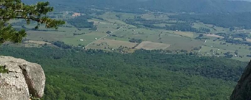
The Old Rag is a popular summit among the Shenandoah peaks because climbing it feels like an actual mountain, perhaps due to its rocky mount, unique among mountains in the Blue Ridge. This particular route begins from the parking area on VA 600 and follows the Ridge Trail up the spine of Old Rag. Continue following this trail along the rocky summit of Old Rag, soak in the views, and then descend along the easterly side of the mountain. When the trail rejoins Weakly Hollow Road, make a hard right along the Weakley Hollow Fire Road that parallels the main road. This will eventually return to the parking area.

Virginia, Waynesboro
02 :44 hrs
27.6 mi
109.79724 ft
Hard
This ride will take you through the amazing Shenandoah Valley. You will encounter a long gradual climb out of the city, which can be challenging for the beginner rider. After you pass the climb, there will be a gradual descent. There will be short stretches of busy streets with heavier traffic throughout the ride. Plan on rolling hills for long stretches.
Virginia, Rockbridge County
02 :02 hrs
20.5 mi
96.36255 ft
Hard
This is a good route for beginners. The roads are all paved and in good condition. The ride is considered an out and back excursion with the exception of the small loop in Goshen. It is located in what is considered the most scenic part of Virginia. The way home from Goshen is easier than the beginning of a ride.
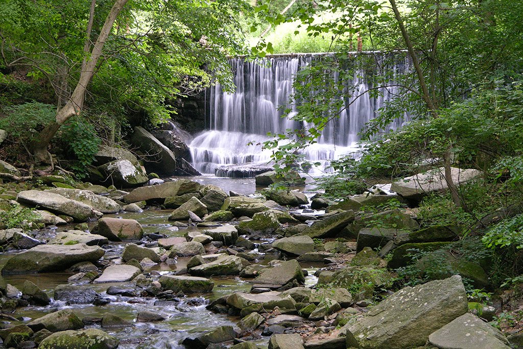
Maryland, Washington County
02 :18 hrs
5.1 mi
347.89536 ft
Hard
This hike is located in Harpers Ferry National Historical Park and features a great deal of history, beautiful thick forests, a mountain ridge, stunning views, and wildlife. In 1783 Thomas Jefferson declared the confluence of the Shenandoah and Potomac Rivers to be “perhaps one of the most stupendous scenes in Nature.” You will hike up to the top of a mountain ridge with gorgeous scenery and make your way to two breathtaking view points overlooking the rivers. Be sure to visit Harpers Ferry and learn about the history of the area before you set off.
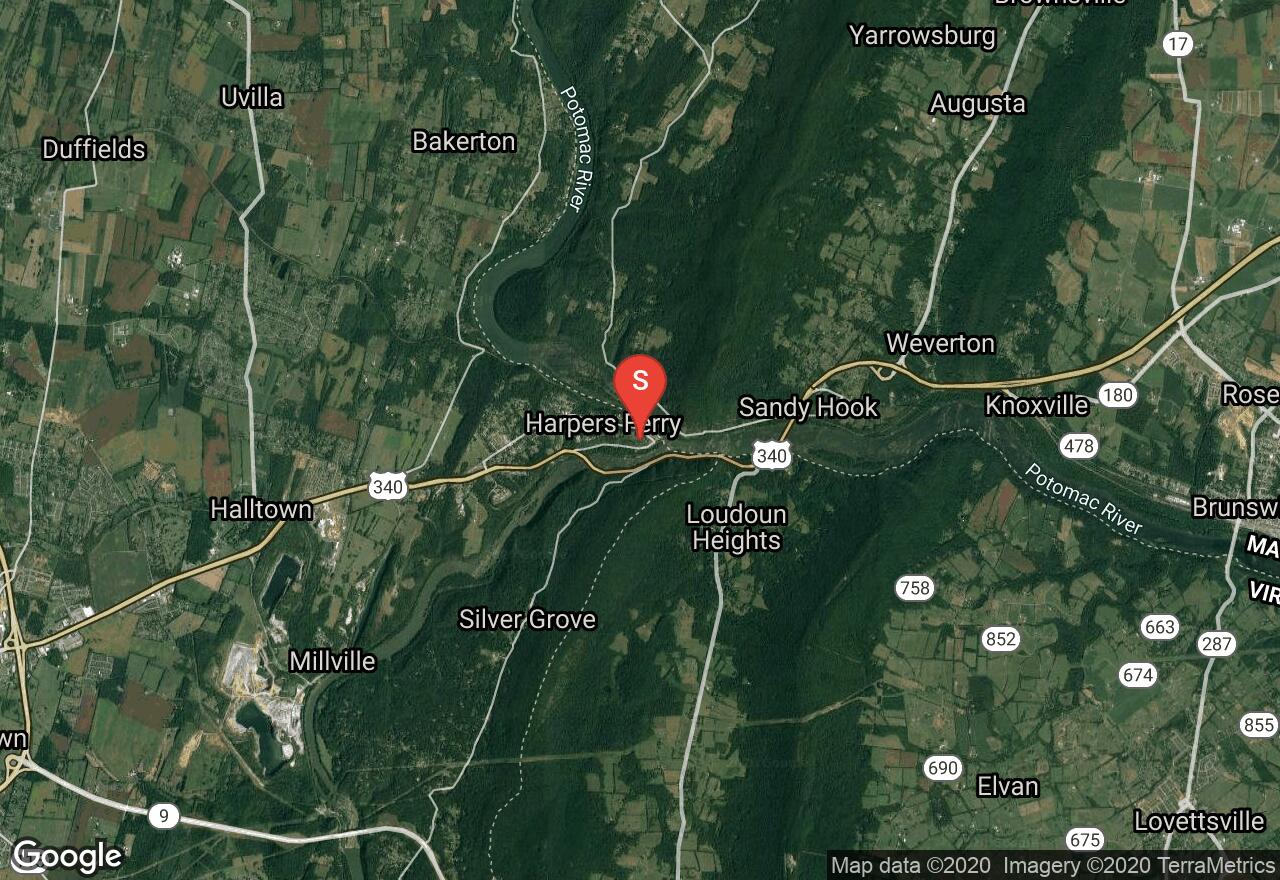
West Virginia, Jefferson County
03 :27 hrs
6.5 mi
62.382416 ft
Easy
The Chesapeake & Ohio Canal Towpath is a historic trail running 184.5 miles from Cumberland, Maryland to Washington, DC . It is relatively flat and is made of crushed stone and clay. This small section of the towpath begins in Harper's Ferry. The park represents over 1,000 years of history, including the arrival of the first successful American railroad, John Brown's attack on slavery, and the largest surrender of Federal troops during the Civil War. As the trail travels to Brunswick MD, it is very scenic and offers many wildlife encounters. A parking fee is required in Harper's Ferry.
Maryland, Potomac
01 :16 hrs
3.7 mi
19.7414 ft
Hard
This hike is located in the C & O Canal National Historic Park only 30 minutes away from the Capital Beltway. The trail is named for the rocky and steep terrain with an abundance of opportunities to scramble over rocks and among cliff edges to attain optimal views of the rugged landscape. You will hike along the Potomac River with stunning views throughout, including views of Mather Gorge and return along the C & O Canal, passing old canal locks and beautiful scenery on a path that is wide and flat.
Maryland, Travilah
01 :27 hrs
4.3 mi
17.8899 ft
Moderate
This hike is located in the C & O Canal National Historic Park only 30 minutes away from the Capital Beltway. On this hike you will pass historic canal locks, some of which are still in use, beautiful water views, including the chute of Great Falls, and a wonderful, rocky landscape which provides stunning scenery. Great Falls is a beautiful waterfall with intense raging water through Mather Gorge. Later on the hike, there are calm water views on the canal downstream. You will find rich history in the park as you hike past the old canal locks, historic buildings, and take the guided tours available here.
West Virginia, Jefferson County
03 :16 hrs
7.2 mi
262.1057 ft
Hard
This trail travels a small section of the Appalachian trail, beginning at Harpers Ferry National Historic Park. The park represents over 1,000 years of history, including the arrival of the first successful American railroad, John Brown's attack on slavery, and the largest surrender of Federal troops during the Civil War. The trail passes many old buildings and ruins that have been preserved. Over 170 bird species as well as many mammal species are located in the park including, the southern flying squirrel and the bald eagle. The Appalachian and Loudoun Heights Trail travels through thick eastern deciduous forest, consisting of chestnut oak, tulip poplar and red maple. The trail leads to Split Rock Overlook, providing views of the town of Harpers Ferry as well as the confluence of the Shenandoah and Potomac River. National Park Service fee is required, fee envelopes provided at the parking lot. The park is open year-round from 9 a.m. to 5 p.m and closed some holidays.
Virginia, Greene County
04 :50 hrs
10.9 mi
388.90216 ft
Expert
This long and strenuous but popular section of the Appalachian Trail parallels Skyline Drive on its way north from Pinefield Gap to Swiftrun Gap. Black bear sightings are common in the lonely peaks of the northern Shenandoah, and there are views aplenty for hikers that wish to brave this day-long stretch of the AT as it slithers along the ridges. Be wary when crossing Skyline Drive, as this route crosses the road often; also, several brief spur trails lead to peaks like the Swiftrun Overlook, Bacon Hollow, and Hightop. Upon arrival at Swiftrun Gap, cross Skyline Drive and take the bridge across VA 33 to walk towards the parking area.
Virginia, Charlottesville
04 :04 hrs
9.2 mi
405.33295 ft
Expert
This arduous day hike follows the famous Riprap Trail in a loop around the incredible scenery of the southern portion of Shenandoah National Park. Descending through the forests of mountain laurel that cover the mountainside, the trail eventually comes to Wildcat Ridge as it switchbacks down into the valley. Turning right and following the Riprap Trail, the path follows the creek for many miles into Cold Spring Hollow. Ascending into the forests once more, hikers will marvel at the views from Calvary Rocks as they make their way across the quartz-studded ridge line. When the Riprap meets the Appalachian Trail, veer right on the AT as it parallels Skyline Drive on the way back to the parking area.
Maryland, Berlin
10 :02 hrs
100.6 mi
12.4915085 ft
Extreme
This is a great 100-mile cycling route through Maryland’s only seaside county, featuring great rural landscapes, curious and historic towns and villages, spectacular waterfronts, abundant travel amenities and more nature than one could possibly imagine. This trip covers a lot of ground and passes through many quaint, historic towns, winds through forest and farm country, and crosses many rivers including the Pocomoke and Nassawango Rivers. The sweeping landscaping offers breathtaking scenery and there are many beautiful points of interest along the way. An alteration of this route is mapped which includes Assateague Island and is called, “Inn to Inn on the Lower Shore.”
Virginia, Greene County
04 :55 hrs
11.3 mi
704.07654 ft
Expert
This strenuous but rewarding river loop begins wending its way down into the valley on the Slaughter Trail. Traveling through pine and deciduous forests on old logging trails, eventually the path will come to the Conway River. Make a hard left onto Conway River Road and parallel the water all the way through the gulch. After a lengthy stretch of walking and several rockhopping fords, the trail will begin ascending back up to the ridgeline. When the trail reaches Skyline Drive, make a hard left on the Appalachian Trail as it parallels the road. Make a brief detour to the left to scramble up the side of Bearfence Mountain for incredible views in all directions before heading back to the parking area.
Virginia, Warren County
04 :28 hrs
10 mi
681.79126 ft
Expert
This beautiful and popular loop hike begins by crossing Skyline Drive and coming to an overlook on Marshall Mountain. The path then follows the Appalachian trail to the summit of Hogsback Mountain, which allows stunning and uninterrupted views of the Massanutten region to the north. Descending along the Hogsback ridge, veer right along Jinney Gray Road which begins curving down the slope on its way to the Little Devils Stairs Trail. Solemn rock monoliths and roaring waterfalls await hikers as they descend through the valley carved by Keyser Run among hidden pools and groves of sapling maples. Upon reaching the bottom of the creek, make a right on the Keyser Run Fire Road as it cuts a wide swath through the open woods and arrives at Bolen Cemetery (with gravestones dating back to the Civil War). When the Keyser Run Fire Road merges with the Sugarloaf Trail, take this back towards Marshall Mountain and the parking area.
Virginia, Augusta County
09 :23 hrs
25.5 mi
844.0032 ft
Extreme
The renowned Wild Oak Loop is perhaps the most popular backpacking trip in the George Washington National Forest, or at least a close second to commensurate sections of the Appalachian Trail. It can also be hiked in smaller portions, as many hikers choose to split the trail into one-way sections that go between the network of roads that intersect the trail. Alternatively, local trail runners have made this loop a destination for runners from around the region. The loop has so much to offer, including ridgeline views of Todd Lake and summit vistas from Little Bald Knob. As the path veers southwest, continuing along the White Oak Trail, numerous verdant deciduous forests await to enclose the avid runner in their shady embrace. Returning along the Hankey Mountain Trail (and the summit of this peak) runners will be rewarded with views of Elkhorn Lake and Staunton Dam, even a brief stint along the edge of the North River Gorge before returning to the parking area.
Maryland, Garrett County
03 :55 hrs
10.5 mi
176.41937 ft
V
The Youghiogheny River, called the “Yough” by most people, is a very popular river for paddlers of all skill levels and is most sought out for its whitewater challenge on this trip from Sang Run Road to Friendsville. This section is referred to as Upper Yough and has the whitewater that made this river famous, specifically its four miles of unrelenting boulder piles, ledges, blocked views, cryptic passages, menacing undercuts, and technical difficulties. After a couple miles of riffles and flat water, you will be faced with Gap Falls, a sloping five-foot ledge and from here it is all downhill through many too many rapids to describe. The rough stuff ends at Kendall and allow a soothing coast to the take out at Friendsville Community Park. Though you may not notice on your first run, this is a very beautiful section of the river with cliffs, graceful hemlocks, falls on side streams, rhododendrons, and beautifully sculpted boulders.
Virginia, Madison County
03 :42 hrs
8.3 mi
369.95813 ft
Expert
Beginning from the Fishers Gap Overlook, which offers many wide-ranging views of its own, this route begins following the Skyland-Big Meadows Horse Trail. This well-trodden path passes through deciduous forests and open meadows on its way through the ridges that run along the edge of Skyline Drive. Crossing the road, take the Lower Hawksbill Trail to ascend to the summit of the highest peak in Shenandoah: Hawksbill Mountain. From the observation platform hikers can look for miles in every direction and take in numerous views of the Blue Ridge topography. After descending from the peak, take the Appalachian Trail on its wandering course back to Fisher’s Gap.
Virginia, Greene County
01 :60 hrs
4.3 mi
368.79462 ft
Hard
Beginning from the parking area on Skyline Drive, cross the road and embark on the Rose River Loop Trail. After a gentle descend and several wide switchbacks, the path runs rewardingly close to the Rose River Falls, complete with pristine mountain waters and a welcoming swimming hole. After snapping some pictures, and perhaps a quick dip beneath the falls, descend further to the confluence of the Rose River and the Hogcamp Branch. As the trail continues upwards along the edge of the Hogcamp, it will approach the rocky cliffs and the proverbial cherry on the cake: Dark Hollow Falls, a series of waterfalls and cascades that echo through the hills. Pass through these thundering glades and cross Skyline Drive once again, and finally make a hard right to take a spur trail back to the parking area.
West Virginia, Jefferson County
01 :39 hrs
2 mi
72.115845 ft
Moderate
This trail leads through Harpers Ferry National Historic Park to Baltimore and Ohio Railroad Potomac River crossing. Harpers Ferry represents over 1,000 years of history, including the arrival of the first successful American railroad, John Brown's attack on slavery, and the largest surrender of Federal troops during the Civil War. The trail passes many old buildings and ruins that have been preserved. Over 170 bird species as well as many mammal species are located in the park including, the southern flying squirrel and the bald eagle. Dogs are allowed but must be kept on a six-foot leash at all times. The park is open year-round from 9 a.m. to 5 p.m and closed some holidays. The park does require a fee, and is purchased at the fee collection entrance station.
Delaware, Sussex County
01 :21 hrs
3 mi
0.9794357 ft
I
The Prime Hook National Wildlife Refuge is a sanctuary for migratory birds and lies along the western shore of Delaware Bay. The refuge contains a variety of habitats, including freshwater and salt marshes, woodlands, grasslands, ponds, and forested areas. It supports 267 species of birds and a variety of reptiles, amphibians, and mammals. This route explores the vast marsh and Shell Beach Pond.
Delaware, Sussex County
00 :17 hrs
0.6 mi
0.68620706 ft
I
The Prime Hook National Wildlife Refuge is a sanctuary for migratory birds and lies along the western shore of Delaware Bay. The refuge contains a variety of habitats, including freshwater and salt marshes, woodlands, grasslands, ponds, and forested areas. It supports 267 species of birds and a variety of reptiles, amphibians, and mammals. Turkle Pond is a very peaceful and quiet area with spectacular views.
Delaware, Sussex County
03 :21 hrs
7.5 mi
0.5675396 ft
I
The Prime Hook National Wildlife Refuge is a sanctuary for migratory birds and lies along the western shore of Delaware Bay. The refuge contains a variety of habitats, including freshwater and salt marshes, woodlands, grasslands, ponds, and forested areas. It supports 267 species of birds and a variety of reptiles, amphibians, and mammals. This self-guided trail leads you into the heart of a salt water marsh on the Prime Hook Creek. The views and scenery are spectacular and there are many exploring opportunities.
Maryland, Easton
08 :48 hrs
88.1 mi
4.669523 ft
Extreme
Delmarva is a long peninsula encompassing Delaware, the eastern shore of Maryland, and part of Virginia and lies between the Chesapeake Bay and the Atlantic Ocean. Much of it consists of commercial farmland and is an ideal place for cycling due to the little-traveled country roads, gently rolling coastal plains and farm fields and pristine views of the sparkling water. In addition, there are several quaint towns, antiques shops, superb seafood restaurants, and a nautical museum. This ride incorporates a short ferry ride on the oldest continuously operating ferry in the United States. There are several other roads to ride and further explore the beautiful countryside and obtain different water views. The Oxford-Bellevue Ferry is open 7 days a week and runs every 15-20 minutes from 9:00 a.m. to sunset but exact times and dates may vary so check on the schedule before making this trip.
Virginia, Augusta County
01 :43 hrs
4.9 mi
73.20395 ft
Hard
This trail follows the serpentine path of the North River through the gorge carved by its ancient waters, wending across wide swathes of sandy riverbed where orchids and ferns grow in abundance. Be prepared to get wet feet, as there are many fords that are necessary along the journey of this beautiful gorge hike. This hike is a longstanding favorite, and is best in late spring and summer; but we wary of flooding and rainstorms, as a flooded gorge may make fording the river impossible and even dangerous.
Delaware, Sussex County
00 :59 hrs
2.2 mi
1.1920929e-7 ft
I
The Prime Hook National Wildlife Refuge is a sanctuary for migratory birds and lies along the western shore of Delaware Bay. The refuge contains a variety of habitats, including freshwater and salt marshes, woodlands, grasslands, ponds, and forested areas. It supports 267 species of birds and a variety of reptiles, amphibians, and mammals. This route explores Stickweed Pond and Twin Pond where you will find solitude and great views. The salt marsh vegetation is rich and great to explore.
Delaware, Sussex County
02 :08 hrs
4.8 mi
0.9753398 ft
I
The Prime Hook National Wildlife Refuge is a sanctuary for migratory birds and lies along the western shore of Delaware Bay. The refuge contains a variety of habitats, including freshwater and salt marshes, woodlands, grasslands, ponds, and forested areas. It supports 267 species of birds and a variety of reptiles, amphibians, and mammals. This route follows Prime Hook Creek and winds through a chain of several ponds before reaching Wilson Pond and Goose Pond near Prime Hook Road.
Maryland, Garrett County
02 :18 hrs
6.5 mi
145.05103 ft
V
The Savage is probably Maryland’s most famous whitewater river and is the site of national championships in the 1972 Olympic Trials, international races, and the 1989 World Whitewater Championships. This section is very rarely runnable but is as beautiful a whitewater run as you will find in Maryland. The creek winds through a tight little gorge in complete isolation with rock cliffs and formations all around with lichens and ferns accenting. The rapids are almost continuous on this section and are formed by cobble bars, lots of ledges, and some boulders and there are many sharp turns requiring technical paddling to navigate. One difficult rapid, about four miles into the run on a straightaway is steep and clogged by jagged rocks and undercut boulders, may be carried on the right. Because the stream is so narrow, trees are an occasional problem and there is a strand of barbed wire by the camps above the take-out.
Delaware, Sussex County
00 :49 hrs
1.8 mi
1.9297915 ft
I
Trussum Pond is located just 6 miles from Laurel, in Sussex County. It is a spectacular destination for paddling and has a great fishing population as well. Delaware has some of the northernmost Bald Cypress trees in the nation and Trussum Pond is the best place to see these stately trees. You will paddle through a maze of gorgeous Bald Cypress trees which grow right out of the water. It is a very unique and beautiful location.
Delaware, Sussex County
02 :37 hrs
6.2 mi
0.19248056 ft
I
This is one beautiful creek, not to be missed! Initially passing through a very narrow corridor, the upper portion travels through hardwoods, especially red maples. Soon marsh appears with small islands of cedar trees. The downstream trip opens into the breathtaking spectacle of wide open marshlands. In the fall, red maples fill the scenery with rich colors.
Virginia, Page County
02 :05 hrs
5.9 mi
503.7266 ft
Expert
Beginning from the Elkwallow Trailhead, veer left towards the Knob Mountain Trail and then another left to walk along the ridge line of Knob Mountain. After a long but vista-filled hike, summit at the peak of Knob Mountain and then continue along the ridge trail as it switchbacks down into Jeremy’s Run. As the trail parallels the water and makes several fords of the river itself, keep an eye out for waterfalls and hesitant wildlife that frequent this region (including black bears!). After exploring the hidden grottoes and watery hollows of Jeremy’s Run, begin ascending back along the gradually disappearing creek towards the Elkwallow Trailhead.
Delaware, Sussex County
02 :49 hrs
6.3 mi
0.93838096 ft
I
The Prime Hook National Wildlife Refuge is a sanctuary for migratory birds and lies along the western shore of Delaware Bay. The refuge contains a variety of habitats, including freshwater and salt marshes, woodlands, grasslands, ponds, and forested areas. It supports 267 species of birds and a variety of reptiles, amphibians, and mammals. Here you will wind through the vast marsh visiting several ponds and finally reaching Petersfield Island near Route 16.
Maryland, Travilah
04 :57 hrs
12 mi
50.350216 ft
IV
The Potomac is the longest and most diverse river system in Maryland, reaching from the cold, high plateau of the Alleghenys to the broad waters of the Chesapeake Bay and tidewater. This section is the Potomac’s finest. It has the best whitewater and the most dramatic scenery. You will begin below Great Falls and run through Wet Bottom Chute and Mather Gorge, then find a mellow stretch to enjoy the views of 80-foot jagged cliffs. Next you will reach Difficult Run, a rocky, plunging course after which the Potomac gradually calms down to a large, lazy river. Islands begin to split the river and more rapids appear over Yellow Falls, a three-foot double ledge, then a long rock garden brings you to Stubblefield Falls, a short easy, bouncy rapid, and from here on to Brookmont is mostly smooth water gliding through rock gardens and dozens of small islands. At Brookmont, take caution running over Brookmont Dam, then expect more turbulent water and a rocky plunge to tidewater. Approaching the Chain Bridge, Little Falls appears and is very steep and split by jagged, rocky islands. Take out at Fletchers Cove.
Virginia, Greene County
01 :52 hrs
4.2 mi
305.8429 ft
Hard
This popular loop hike begins descending on the edge of the river on the South River Falls Trail. Walking next to the water, hikers will enjoy the many verdant deciduous groves that grow on the edge of the creek. The sounds of rushing water may greet the ears as the route approaches the falls themselves, and curves around the edge of the waterfall base. Returning from this brief spur trail, veer right towards South River Road and take this through the water-carved valleys back towards Skyline Drive.
Delaware, Sussex County
00 :40 hrs
1.5 mi
0.987796 ft
I
The Prime Hook National Wildlife Refuge is a sanctuary for migratory birds and lies along the western shore of Delaware Bay. The refuge contains a variety of habitats, including freshwater and salt marshes, woodlands, grasslands, ponds, and forested areas. It supports 267 species of birds and a variety of reptiles, amphibians, and mammals. This is a gorgeous place to paddle where you will find great views and lots of wildlife in a very quiet and peaceful area.
West Virginia, Tucker County
04 :08 hrs
10.7 mi
140.04407 ft
Expert
The trails in this circuit loop are located in Dolly Sods Wilderness. All trails are well marked starting on Bear Rocks Trail heading West. At the trail head the Army Corp of Engineers still display warning signs for hikers that there may be unexploded ordnance from WWII in the area. The surface of the circuit are mostly dirt and rock with some river crossings. While hiking Bear Rocks Trail, Rocky Ridge Trail, and Dobbins Grade Trail there will be sites of high hardwood forest, red spruce trees, wind shaped sandstone, alpine bogs and meadows. This is a popular hike with areas of breath-taking beauty and many photo opportunities.
Delaware, Sussex County
02 :19 hrs
5.5 mi
1.1920929e-7 ft
I
Slaughter Creek flows through vast, unspoiled salt marshes backed by a curtain of forest. It is in the Prime Hook National Wildlife Refuge which is a sanctuary for migratory birds and lies along the western shore of Delaware Bay. The refuge contains a variety of habitats, including freshwater and salt marshes, woodlands, grasslands, ponds, and forested areas. It supports 267 species of birds and a variety of reptiles, amphibians, and mammals. The scenery is intriguing and changes between different, untamed outdoor neighborhoods.
Virginia, Madison County
03 :32 hrs
7.4 mi
685.5984 ft
Expert
Perhaps one of the most popular loop hikes in Shenandoah, this route begins from the trailhead on Weakley Hollow Road and proceeds to the right along the White Oak Canyon Trail. Running parallel to the Robinson River, hikers will see numerous waterfalls, cascades, rock formations, and hidden pools. When the path intersects with Skyland-Big Meadows Horse Trail, take a hard left and continue a steep upward ascent. This path follows several switchbacks until it comes near to Skyline Drive, and then makes another left onto the Cedar Run Trail. The descent through Cedar Run is similarly stunning, offering waterfalls and grottoes along the creek as it wends through the valley back toward the parking area.
Maryland, Frederick County
02 :02 hrs
5.3 mi
144.1313 ft
Hard
Sugarloaf Mountain is an isolated mountain that rises about 700 feet above the rest of the surrounding countryside. The mountain itself is made of quartzite and has been less susceptible to weathering. The terrain is steep and rocky and though the trails are well-marked and maintained, the hike can be rather strenuous. The views atop this mountain are phenomenal and stretch for miles. The rock structures, trees, wildflowers, and wildlife on this hike are a real treat. Take note that mountain biking at Sugarloaf Mountain is allowed on the yellow trail only.
West Virginia, Pendleton County
05 :09 hrs
23.2 mi
811.30896 ft
Expert
Located in Monongahela National Forest, this trail is considered one of the best mountain bike trails in West Virginia. the trail starts in thick forest cover with a few short ascents and moderate downhill sections. As the trial progresses, there are some difficult short steep uphill sections as well as a couple hike-a-bike sections. The ridge line has interesting rock formations and features amazing views of the valley below. There are few narrow places along the trail that involve careful maneuvering. As the trail descends there are small berms on some of the turns as well as a few switchbacks. The trail is well marked and is in good shape. It is typically tackled using a shuttle and starts from the South end traveling to the north end.
Maryland, Easton
02 :13 hrs
22.2 mi
4.529985 ft
Hard
Delmarva is a long peninsula encompassing Delaware, the eastern shore of Maryland, and part of Virginia and lies between the Chesapeake Bay and the Atlantic Ocean. Much of it consists of commercial farmland and is an ideal place for cycling due to the little-traveled country roads, gently rolling coastal plains and farm fields and pristine views of the sparkling water. In addition, there are several quaint towns, antiques shops, superb seafood restaurants, and a nautical museum. This ride incorporates a short ferry ride on the oldest continuously operating ferry in the United States. There are several other roads to ride and further explore the beautiful countryside and obtain different water views. The Oxford-Bellevue Ferry is open 7 days a week and runs every 15-20 minutes from 9:00 a.m. to sunset but exact times and dates may vary so check on the schedule before making this trip.
West Virginia, Tucker County
03 :52 hrs
14.8 mi
163.80096 ft
Expert
This loop offers the best riding of the Canaan Valley Institute, with the famous Moon Rocks section, and amazing 360° views on top of Hoodoo Rocks. The beginning of the trail travels through meadows and forest with some rocky sections as well as a stream crossing. Trials Road trail can be very muddy, even in dry weather the mud bogs can be an issue. Along the loop there are many downhill and uphill sections which can get quite technical and steep. Moon rocks are a cratered ridge forming a plateau that offer a challenging ride. The trail ends south of Davis on highway 32, travel the main road back to the parking lot.
Virginia, Charlottesville
05 :25 hrs
13.2 mi
482.6858 ft
Extreme
This ambitious and incredibly beautiful loop hike is indeed what separates the true Shenandoah hiker from the Sunday drivers. Beginning from Skyline Drive, the path follows the Appalachian Trail briefly before veering left along the Austin Mountain Trail. Keep straight through the four way intersection and after a brief descent yield right along the Rockytop Trail. This view-studded trail follows the Rockytop ridge line, allowing many viewpoints for the vista-hungry hiker. Descend down into the valley and make a hard right onto the Big Run Portal Trail, which parallels the river and makes more than a few adventurous fords across the rapids. (Warning: be aware of flood warnings and water levels before attempting this hike, as some river crossings may be dangerous or impassable at high water levels.) As the trail begins to wind its way through the valleys and back up into the mountains, Big Run will dwindle to a creek and eventually disappear as the Portal Trail intersects again with the Austin Mountain Trail to end where it began. This hike is a Shenandoah classic.
Maryland, Garrett County
02 :47 hrs
3.3 mi
200.36536 ft
Hard
Located in the Potomac State Forest, this is a gorgeous hike through a hemlock and mountain laurel filled canyon which follows Lostland Run all the way to the Potomac River. There are several stream crossings on footbridges, a waterfall, and many opportunities to view wildlife. The first mile of the hike is over rough and rocky terrain but it becomes easier as you approach the stream.
West Virginia, Grant County
01 :48 hrs
4.5 mi
162.02905 ft
Moderate
This hike into the Dolly Sods Wilderness descends Wildlife Trail into Red Creek Canyon. You travel through predominantly hardwood forest to a rocky overlook that is a great spot to snap some photos. From the overlook it’s an uphill walk to the Rohrbaugh Trailhead were you may have a vehicle waiting or you can reverse your course.
Maryland, Howard County
00 :54 hrs
2.5 mi
33.545555 ft
Moderate
Moderate loop trail with hills and long flat stretches. Off the Red Trail. Green to Blue to Green and back to Red. Intersections are marked with some trail blazing as well.
Maryland, Garrett County
01 :51 hrs
4.7 mi
156.66699 ft
Hard
Deep Creek Lake State Park located in Garrett County and surrounds Deep Creek Lake, a reservoir that was created with the construction of a dam in 1923. There are trails for hiking and mountain biking as well as water sports on the reservoir. This trail takes a large loop around the park. It circles the base of the mountains and rises to the summit where several cell phone towers and a former fire tower are located. You will then descend the mountain and reach the site of an abandoned coal mine before returning.
Maryland, Montgomery County
11 :30 hrs
42.6 mi
38.822243 ft
Easy
The Chesapeake and Ohio Canal, abbreviated as the C & O Canal, operated from 1831 until 1924 and runs parallel to the Potomac River from Washington D.C. to Cumberland. The total length of the canal is about 184 miles and has an elevation change of 605 feet that is accommodated by 74 canal locks. There were over 150 culverts and 11 aqueducts for the crossing of streams. The canal way is now maintained as a park that is overflowing with history. The trail is wide, flat, and made up of hard-packed dirt. Along with stunning river, forest, and mountain views throughout, this section of the towpath passes Harpers Ferry at the confluence of Shenandoah and Potomac Rivers, a great place to visit.
Maryland, Allegany County
16 :15 hrs
60.1 mi
63.470314 ft
Easy
The Chesapeake and Ohio Canal, abbreviated as the C & O Canal, operated from 1831 until 1924 and runs parallel to the Potomac River from Washington D.C. to Cumberland. The total length of the canal is about 184 miles and has an elevation change of 605 feet that is accommodated by 74 canal locks. There were over 150 culverts and 11 aqueducts for the crossing of streams. The canal way is now maintained as a park that is overflowing with history. The trail is wide, flat, and made up of hard-packed dirt. Along with stunning river, forest, and mountain views throughout, this section of the towpath passes through a particularly isolated landscape, runs through the Paw Paw Tunnel, past many farm fields, and ends in Cumberland after passing a large rail yard.
Maryland, Washington County
03 :19 hrs
8.8 mi
234.39435 ft
Expert
The Appalachian Trail is the most famous walking rail in the world and extends from Springer Mountain in Georgia to Mount Katahdin in Maine. Thirty-nine miles of this trail run through Maryland. This section is rather hilly with a number of climbs and descents and is also a very historic section, passing through a Civil War battle site. The hike begins with a steep descent, rises a bit, and then makes a slow and shallow drop to Turners Gap. Only a series of roadside plaques marks the battle at Turners Gap. The rest of the route consists of a flat section and a long steady uphill climb to Lambs Knoll before dropping slowly to Gapland Road.
Maryland, Allegany County
05 :47 hrs
13.8 mi
24.241203 ft
III
The Potomac is the longest and most diverse river system in Maryland, reaching from the cold, high plateau of the Alleghenys to the broad waters of the Chesapeake Bay and tidewater. For this section, the Potomac cuts through the ancient Blue Ridge and its foothills and forms the first whitewater since its headwaters. To begin, you will navigate through The Needles, and intricate ledgy staircase that is a perfect novice whitewater run except when the water is high, novices should skip this section as the river runs stronger than it looks. Just after the Shenandoah River joins, the river tumbles over a series of jagged ledges and runs over two distinct drops named Whitehorse Rapids. Below this the river glides through a beautiful maze of rocks and islets to another gap through South Mountain and Short Hill. A smooth and swift section allows time to relax before a gap in Catoctin Mountain to the take out at the Route 15 bridge.
Maryland, Washington County
10 :52 hrs
40.3 mi
28.165459 ft
Easy
The Chesapeake and Ohio Canal, abbreviated as the C & O Canal, operated from 1831 until 1924 and runs parallel to the Potomac River from Washington D.C. to Cumberland. The total length of the canal is about 184 miles and has an elevation change of 605 feet that is accommodated by 74 canal locks. There were over 150 culverts and 11 aqueducts for the crossing of streams. The canal way is now maintained as a park that is overflowing with history. The trail is wide, flat, and made up of hard-packed dirt. Along with stunning river, forest, and mountain views throughout, this section of the towpath passes open farm fields two dams, and a pond known as Big Pool.
Maryland, Frederick County
02 :35 hrs
10.2 mi
205.58014 ft
Expert
Gambrill State Park is a beautiful mountain park located on the ridge of the Catoctin Mountains and its most popular feature is the network of trails. The Blue Trail is a challenging and demanding ride that is very popular and sought out for its beauty and difficulty. The trail is rocky singletrack running through dense woods and over mountainous terrain. There are some strenuous climbs involved as well. You will reach the top of High Knob where there are three stone overlooks with breathtaking views of the Frederick and Middletown Valleys.
Maryland, Brookmont
10 :02 hrs
37.1 mi
54.41784 ft
Easy
The Chesapeake and Ohio Canal, abbreviated as the C & O Canal, operated from 1831 until 1924 and runs parallel to the Potomac River from Washington D.C. to Cumberland. The total length of the canal is about 184 miles and has an elevation change of 605 feet that is accommodated by 74 canal locks. There were over 150 culverts and 11 aqueducts for the crossing of streams. The canal way is now maintained as a park that is overflowing with history. The trail is wide, flat, and made up of hard-packed dirt. Along with stunning river, forest, and mountain views throughout, this section of the towpath passes through Great Falls Park with a majestic waterfall. There are many parking areas, usually every few miles, allowing you to shorten or lengthen your ride.
Maryland, Baltimore County
04 :24 hrs
10.8 mi
53.10971 ft
IV
This section of Gunpowder Falls includes the exciting descent over the Fall Line. The Fall Line begins just below Route 1 and soon after put-in is where the whitewater starts and the river tumbles down a boulder and ledgy bed. The entire trip runs within the confines of a shallow, wooded gorge, protected by a state park. Take out at Route 7 for best convenience or at Route 40 if you want to catch every last rapid. Route 40, however, has “no parking” signs, but there is a park access just upstream on the left off Jones Road. It is about a 200-yard walk up from the river.
Maryland, Garrett County
00 :26 hrs
1.1 mi
39.96515 ft
Easy
This beautiful hike encompasses three waterfalls, including the highest free-falling waterfall in Maryland, Muddy Creek Falls. Muddy Creek Falls lies at the northern end of the trail, Swallow Falls is at the southern end of the trail, and Tolliver Falls is a short trail walk away from Swallow Falls. Tolliver Falls is especially picturesque with a calm water pool below and its thick surrounding woods and seclusion. This hike begins just off Maple Glade Road and follows alongside the river to visit each waterfall.
Virginia, Nelson County
01 :55 hrs
4.4 mi
210.57172 ft
Hard
Though one of the lesser known loop trails off the Blue Ridge Parkway, the White Rocks Falls and Slacks Overlook Loop is certainly a rare beauty. As the White Rocks Falls Trail winds down into the valley and hugs the edge of White Rock Creek, vistas of surrounding mountainscapes may come into view from between the trees. Passing by several waterfalls that cascade down the edges of the gorge, the trail will again cross the parkway and become the Slacks Overlook Trail. This path offers further views to the north before snaking back to the parking area.
Virginia, Madison County
05 :14 hrs
11 mi
618.9823 ft
Expert
Beginning from the parking area on Skyline Drive, this circuitous but rewarding loop begins by descending into White Oak Canyon. Passing through the tangle of trails near Crescent Rocks, the path continues down along the river on the White Oak Canyon Trail. After passing several cascades and waterfalls, the path arrives at the White Oak Canyon Upper Falls, a popular destination among Shenandoah hikers. From there, cross the quaint wooden bridge and follow the Skyland Big Meadows Horse Trail before making a right onto Old Rag Road. After a brief stint along the ridgeline, veer left onto the Corbin Hollow Trail and enjoy the quiet beauty of these Appalachian hollows as the path parallels the river. At the mergence of Corbin and Weakley Hollows, make a hard right onto the Robertson Mountain Trail and ascend to the summit. From Robertson, take in the staggering views of Old Rag and Thorofare mountains before descending down the ridge. Reuniting with Old Rag Road, take this gently loping fire road back towards the parking area.
Maryland, Harford County
00 :28 hrs
2.4 mi
3.6318684 ft
Easy
This trail is located in the Susquehanna State Park which is recognized for its hiking and biking trails, camping, rock outcroppings, boating, and much more. This is a beautiful paved trail along the stunning Susquehanna River that flows majestically by. This is a rail-trail that follows the corridor built in 1926 by the Philadelphia Electric Company to transport materials from Havre d’Grace to the Conowingo Dam. From the trail you will enjoy wooded wetlands, songbirds, wildflowers, and a dense canopy overhead, shading the trail while still allowing frequent river views.
West Virginia, Jefferson County
01 :52 hrs
4.4 mi
14.336266 ft
II
The Shenandoah River is a tributary of the Potomac River. This is a beautiful river and passes islands, cliffs, and travels to the historic Harpers Ferry. This section of the river begins with easy flat water and then the first rapid begins against high cliffs as the river bends right. The biggest rapid on this run is Bull Falls. It is A large ledge rapid that has many slots and channels depending on water levels.
Maryland, Harford County
02 :03 hrs
5.7 mi
72.39269 ft
Hard
This is a great hike that has plenty to offer and many beautiful sights to see without a great challenge. You will ramble through hardwood forest with expansive views of the Susquehanna River, old farm ruins, and bald eagles are often sighted. Enjoy the wildflowers, a pine grove which was planted as a lumber crop in the early nineteenth century, and a beautiful open meadow.
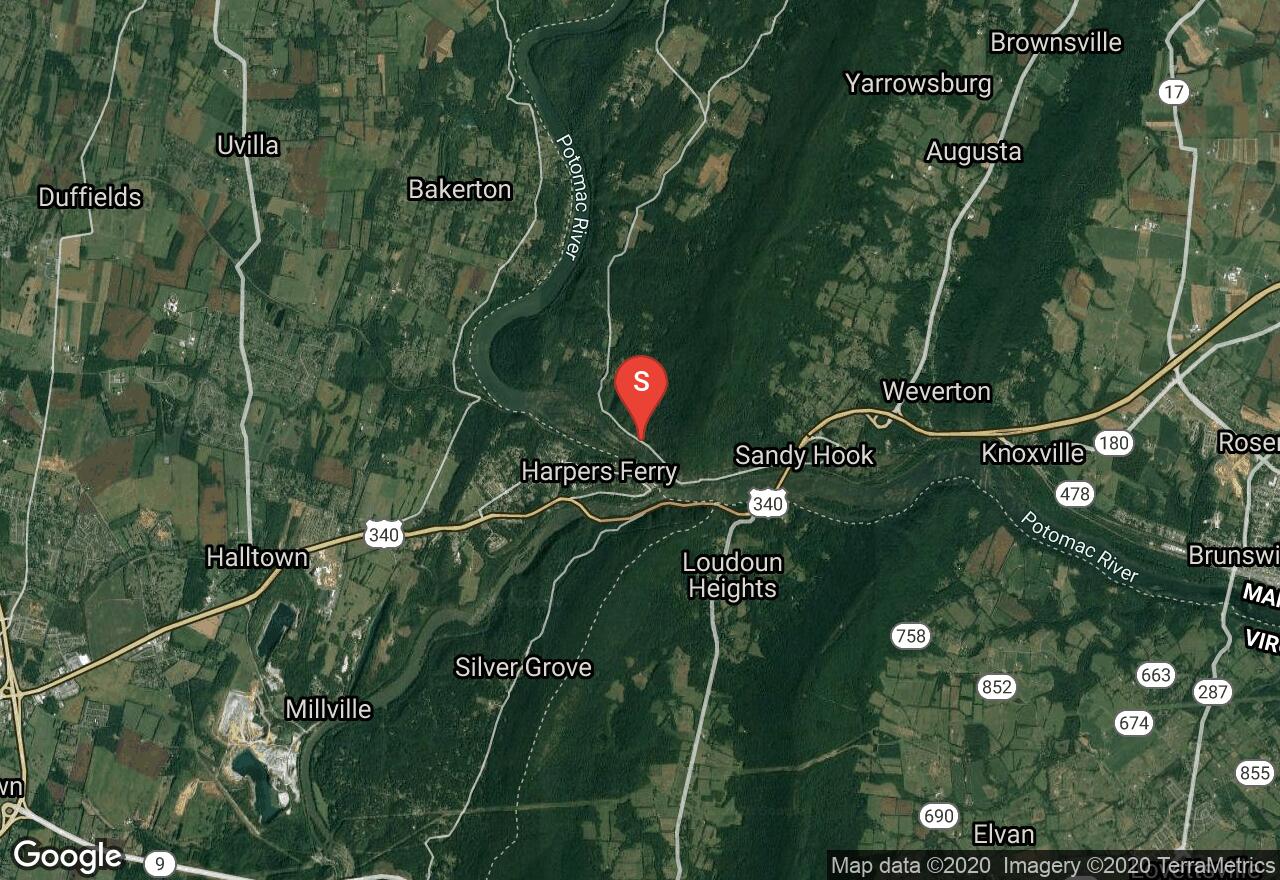
West Virginia, Harpers Ferry
02 :23 hrs
5.3 mi
257.48907 ft
Hard
The historic and scenic community of Harpers Ferry is the jumping off point for this woodland loop hike . After parking (fee required), hikers cross the Shenandoah River via the Interstate 340 Bridge and follow a portion of the Appalachian Trail for a short distance to a loop on Loudoun Heights. A spur trail at the distant extant of the loop takes you to an excellent viewpoint of the confluence of the Shenandoah and Potomac Rivers.
Maryland, Harford County
01 :19 hrs
5.1 mi
86.54703 ft
Hard
This challenging ride meanders through the Susquehanna State Park, taking you through a very diverse area including both heavy forest cover and open fields. Along with the natural diversity, this trail offers a glimpse into the past with several historic landmarks including the only working gristmill in Harford and Cecil Counties. This park is home to man bike races and the trails are designed to give a bit of a challenge. Following a singletrack trail, you will make a few challenging climbs and a couple steep descents. There is beautiful scenery through these rolling hills and thick forest surrounding you on the trail, then as you near the river you will have gorgeous views over the water.
Maryland, Frederick County
01 :23 hrs
5.5 mi
154.48193 ft
Hard
Gambrill State Park is a beautiful mountain park located on the ridge of the Catoctin Mountains and its most popular feature is the network of trails. The Yellow Trail is a challenging and demanding ride. The trail is rocky singletrack running through dense woods and over mountainous terrain. There are some strenuous climbs involved as well. You will reach the top of High Knob where there are three stone overlooks with breathtaking views of the Frederick and Middletown Valleys.
Maryland, Washington County
02 :11 hrs
21.8 mi
30.56549 ft
Hard
The Western Maryland Rail Trail is a paved route that is packed with history and the trail will take you through several eras of American history. You can access the trail from many points and the main trailhead is in the town of Hancock, but this route extends the entire length of the trail from Fort Frederick State Park to Pearre Road. You will parallel the C & O Canal and its unpaved towpath, which was used to transport coal from Cumberland to Georgetown. The trail has magnificent views of the Potomac River, large rock outcroppings, the ruins of the Round Top Center Mill, historical markers for Little Pool and Park head cemeteries, and wildlife such as deer and wild turkey.
Maryland, Friendsville
03 :32 hrs
8.3 mi
8.199982 ft
I
The Youghiogheny River, called the “Yough” by most people, is a very popular river for paddlers of all skill levels and is most sought out for its whitewater challenge from Sang Run to Friendsville. This section is perfect for beginners with lots of flat water and quick water with only a short section of small, Class I waves. It is a really pleasant place to paddle as the reservoir is relatively narrow and fringed by high slopes and thick forests. This area gets very busy so it is best to go early in the morning when it is still calm. Hazards on this route are limited to that of the heavy crowds and power boats. Take out point is across the border into Pennsylvania on the right hand side just after floating under the Route 40 bridge.
Maryland, Worcester County
02 :49 hrs
7 mi
0.09387327 ft
SK II
Scarboro Creek is located within the E.A. Vaughn Wildlife Management Area across the Chincoteague Bay from Assateague Island. The E.A. Vaughn WMA has been improved by biologists to most benefit wildlife and create the best habitat for them. Amongst the marshes and forests, many song birds, raptors, shore birds, and migratory birds are found here along with a great variety of mammals, reptiles, and amphibians. This is a beautiful place to explore and observe wildlife and study the rich plant life. Take a trip up the Scarboro Creek as well as the Pikes Creek and enjoy peaceful paddling. When you are on the open bay, be cautious of rough water due to high winds.
West Virginia, Tucker County
02 :50 hrs
8 mi
171.74072 ft
IV
The Stony River is a tributary of the North Branch Potomac River in Grant County. This is a small technical creek with some fairly complex rapids scattered throughout the run. This river requires maneuvering among boulders, over ledges, and through complicated drops. Mining and timbering activity has pushed trees into the river be very cautious of hazards.
Virginia, Page County
05 :11 hrs
4.5 mi
352.37326 ft
Expert
The south approach to Strickler Knob begins by climbing to the top of one ridge line, then descends into the low-lying valley below to follow the creek. After a lengthy stint in the valley, the trail coincides with the more popular Strickler Knob Trail and winds its way up the ridge line to the summit of Strickler Knob. The peak offers beautiful views of the surrounding region.
Maryland, Baltimore County
01 :23 hrs
4 mi
29.896759 ft
Moderate
This hike is located in the Loch Raven Watershed which is the primary water source for the Baltimore metropolitan area. The Loch Raven Dam and Reservoir are located on the Big Gunpowder River and provide a beautiful destination for hiking and mountain biking. There is an extensive trail system surrounding the reservoir and exploring the expansive and beautiful forest. Mountain laurel, tulip poplar, and a great diversity of other trees and wildflowers create peaceful scenery.
West Virginia, Harpers Ferry
02 :16 hrs
5.4 mi
247.44864 ft
Hard
The views from Split Rocks are a favorite among Northern Virginians and West Virginians alike; beginning from the parking area in Harpers Ferry, the trail begins following the Appalachian Trail through the heart of this historical American town. Crossing over the Harper's Ferry Bridge, the trail veers to the right parallel to the mighty Potomac River. After intersecting with VA 340, be careful crossing the bridge and hiking along the narrow shoulder of this road toward Split Rocks. Take a sharp left onto the steep Split Rocks Trail that traces the spine of the ridge, offering views of the surrounding area, rivers, and the city of Harpers Ferry. Finally, the trail links back up with the Appalachian Trail to lead back to the parking area after crossing the Shenandoah River.
Maryland, Baltimore County
02 :12 hrs
5.8 mi
45.36744 ft
Hard
Liberty Reservoir is in the suburbs of Baltimore and divides Baltimore County and Carroll County. The reservoir is open to a variety of outdoor recreational activities. At its northern end, the lake is narrow and in times of plentiful rain, completely fills the small canyon of the Patapsco River’s North Branch. The lake edge runs up against steep slopes that rise 200 feet and small feeder streams cascade down through narrow gorges into small coves, making for stunning scenery. There are eight steep climbs on this route but none are more than about 150 feet. Limited parking is available on the side of Glen Falls Road.
Maryland, Prince George's County
06 :33 hrs
16.4 mi
2.9 ft
SK II
This trip explores several tributaries of the Patuxent River; Mattaponi Creek, Lyon’s Creek, Weir Creek, and Broad Creek. These tributaries may even be more alluring than the main river as they wind and intimate path through the marshes with a great diversity of beautiful plant life. The area is also filled with much wildlife and the quiet environment allows you to view them in their natural habitat, especially waterfowl and beaver, muskrat, and river otter. Every season has a little something different to offer and this route is great for any time of year. The put-in site is used by both powerboaters and paddlers and these small side streams allow you to escape the noise of Jug Bay.
Maryland, Snow Hill
08 :59 hrs
89.9 mi
12.570446 ft
Extreme
The lower Eastern Shore of Maryland is a cyclist’s dream as it is almost totally flat, and has great scenery, much preserved history, and bicycle-friendly inns, many of which have joined together to provide special services to cyclists. This tour covers a lot of ground as it leaves Snow Hill, swoops down to the public landing on Chincoteague Bay, leads through chicken-farm country to historic Berlin, continues to Assateague Island where wild ponies graze, and visits Berlin’s restored Atlantic Hotel, cross the Pocomoke River and Nassawango Creek, visit an old iron furnace and restored town, and end back in Snow Hill. This tour is inspired by Viewtrail 100, a well-marked 100-mile tour mapped out by Worcester County.
Virginia, Charlottesville
05 :57 hrs
4.8 mi
546.29944 ft
Expert
This popular out-and-back day hike is unique in the Shenandoah region because it begins not from the Parkway but rather from VA 663. Following the Furnace Mountain Trail, the path switchbacks up the side of Furnace Mountain. Take the Furnace Mountain spur by turning left and enjoy the views of Trayfoot Mountain and Austin Mountain in the distance. As the path continues along the rugged ridge line, hikers will pass through oak and evergreen forests with possible glimpses of deer and numerous bird species that inhabit Shenandoah National Park, or perhaps even signs of the reclusive black bears that roam the mountains in spring. When the trail intersects with the Trayfoot Mountain Trail take a left to arrive at the Blackrock Summit, which allows more stunning views of the shadowed hills of Shenandoah.
Virginia, Augusta County
03 :09 hrs
7.8 mi
279.8109 ft
Hard
Beginning on the Road Hollow Trail that leads up the side of Shenandoah Mountain, this wide and well-kept trail system offers views of the surrounding area from the very start. Intersecting with the Shenandoah Mountain Trail, veer right as the path skirts the edge of the mountain. Soon the path will split once again onto the Jerry’s Run Trail that snakes through the valley carved by Jerry’s Run amidst hemlock and mountain laurels. Follow this gentle river until it coincides with Ramsey’s Draft, and veer right along the Ramsey’s Draft Trail. This path runs parallel to the river, and brings hikers through several fords and emerald old growth forests on its way back to the parking area.
Virginia, Page County
06 :28 hrs
5.9 mi
503.7266 ft
Expert
After turning off the Appalachian Trail and onto the Neighbor Mountain Trail, take in the stunning views of the surrounding Shenandoah peaks and valleys. The trail wends along the ridge line before arriving at the Neighbor Mountain summit for more spectacular views, and then dives down into the canyon carved by Jeremy’s Run. After a brief walk along the river, arrive at the pools and waterfalls of the bottommost portion of the creek for a moment of serenity or a brief swim before climbing back up the Neighbor Mountain Trail towards the parking area.
Virginia, Madison County
05 :56 hrs
13.2 mi
844.03955 ft
Expert
This strenuous loop hike begins ascending the Staunton River Trail just north of Graves Mill. Hugging the edge of the river, this initial section of the trail offers pristine cascades and mini-waterfalls on its way into the mountains. After following almost the entirety of Staunton River, the path makes a left when it encounters the Fork Mountain Trail. After a brief walk along the ridgeline, another left brings hikers onto the Jones Mountain Trail. Moving along the ridgeline, the trail offers views in all directions over the peaks and valleys of Shenandoah. Passing Bear Church Rock and arriving at the Jones Mountain summit, look south for the rocky profile of Old Rag in the distance before descending back through the gorge along the Staunton River Trail.
Virginia, Rappahannock County
04 :28 hrs
10.2 mi
524.6116 ft
Expert
This popular loop hike begins by following the Hazel Mountain Trail into the ridges of the Shenandoah. From several open switchbacks, take in some stunning views of the surrounding area. After a brief jaunt along this ridge trail, the path veers left along the White Rocks Trail that parallels the beginnings of the Hazel River. A brief spur trail into the gully will bring hikers to the gorgeously secluded Hazel River Falls, a forgotten grotto of rock formed by nearly 20 feet of pounding water. Walk amidst flowering laurels and Tuscarora quartz (which gives the trail its name) as the path continues along the White Rocks Trail. After descending from the ridgeline, the trail makes a hard left onto the Hazel River Trail that parallels the edge of the now-roaring Hazel River. Watch for more cascades and waterfalls, and be careful fording this river that is often swelled in the springtime. Some hikers choose to make this an out-and-back hike, stopping at the end of the Hazel River Trail. For a longer loop hike, however, continue on the Sams Ridge Trail for more views and a circuitous ridge-hopping path back to the parking area.
Virginia, Charlottesville
03 :35 hrs
8.5 mi
385.53665 ft
Hard
This strenuous loop follows Madison Run Road, an abandoned mountain road through the valley of Madison Run, before ascending to Austin Mountain. Begin by following the Austin Mountain Trail off the parkway, then make a left on Madison Run Road. After a series of switchbacks into the valley, the trail follows the edge of the creek and offers idyllic and seldom-disturbed gullies. Turn right onto Austin Mountain Trail and begin following the spine of the mountain up to the rocky summit. After passing numerous fascinating geological formations unique to the Blue Ridge Mountains, come to the summit of Austin Mountain and catch a gorgeous look at Trayfoot Mountain in the distance. As the loop nears its close, the trail will intersect with the Rockytop Trail briefly before veering right back to the parking area.
Virginia, Rockingham County
04 :44 hrs
4.5 mi
491.75085 ft
Hard
Beginning from the parking area on Two Mile Run Lane, the Onemile Run Trail begins snaking its way through the mountains towards Shenandoah National Park. Several hidden pools and waterfalls await hikers on the trail as it hugs the edge of the creek, amid maple and pine groves. Eventually, the trail will ascend to the ridgeline and give stunning views of the surrounding the valleys on its way towards Skyline Drive. Once the path intersects the road, take a brief detour to the left to arrive at Two Mile Run Overlook for views of Massanutten in the distance.
Virginia, Prince William County
04 :28 hrs
12.5 mi
74.41516 ft
Expert
This long loop hike around Prince William Forest Park begins from the Visitor Center and follows the South Valley Trail along the edge of the South Fork Quantico Creek. Passing by an old pyrite mine, take a brief detour on Pyrite Mine Road and then veer right on the Cabin Branch Mine Trail. After a long trek northward on the North Valley Trail past the lake, the trail then intersects with Taylor Farm Road and progresses towards the Taylor Farm site. The remainder of the journey follows the High Meadows Trail until it hits the creek and once again becomes the South Valley Trail on its way back to the parking area. Hikers will enjoy numerous views of the tiny cascades in Quantico Creek, the dismantled buildings of old mines and dwellings, as well as the quiet solitude of well-kept forest roads that glisten with fall colors in the autumn.
Maryland, Wicomico County
06 :18 hrs
63 mi
11.461307 ft
Extreme
Nautical history buffs ought to especially enjoy this ride, as its destination, Deal Island in the Tangier Sound, is the home of one of the last remaining skipjack fleets. Skipjacks are sailing vessels that are not motorized and in the nineteenth century were the primary way fishermen tongued for oysters. On this ride you will also enjoy cycling through miles of farmland, the tidal marshland of the Deal Island Wildlife Management Area, and the historic town of Princess Anne which is home to the 200-year old Washing Hotel. The terrain is mostly flat but the land is exposed and there is a significant prevailing wind from the west. This route is marked in orange arrows numbered 62 by the Salisbury State University Cycling Club.
West Virginia, Mineral County
04 :38 hrs
10.3 mi
7.7678223 ft
I
Jennings Randolph Lake is located on the North Branch Potomac River in Garrett County. It was constructed by U.S. Army Corps of Engineers in 1981. The dam was built to make a freshwater reservoir and to control flooding on the North Branch of the Potomac River. It offers a pleasant place for canoeing, fishing and just relaxing. The boat ramp is located at the Howell Run Lake Access area.
Maryland, Calvert County
01 :21 hrs
3.8 mi
31.438759 ft
Moderate
Flag Ponds Nature Park is a little-known gem just up the road from the better-known Calvert Cliffs State Park. Flag Ponds is named for the three small ponds located just inland from the beach, where wild iris (or flag) blooms in profusion each May. This beautiful hike explores thick forest, hilly terrain, and crosses a boardwalk over an open swamp. In addition, you will visit the shoreline of each of the small ponds, Richardson’s Pond, Duncan’s Pond, and Todd’s Pond, as well as taking a side trail to an overlook and swimming beach on Chesapeake Bay.
Delaware, Sussex County
04 :12 hrs
9.9 mi
0.07724285 ft
I
Launching from Milton, the early parts of this trip pass through partly forested, swampy shores. As the river progresses, you will see less woods and increasingly wider marshes until you are eventually completely surrounded by extensive marshland. There are no difficulties or challenges on this route. This is a great place for viewing a large variety of shorebirds.
West Virginia, Tucker County
02 :12 hrs
4.9 mi
5.254822 ft
I
Mount Storm Lake is a popular tourist destination located in Grant County. This 1200 acre lake was built in 1965 as a cooling lake for power generation. The power plant is operated by Dominion Virginia Power and heats the reservoir to 20-25 degrees above normal. The lake is up to 160 feet deep and the bottom can be clearly seen at depths of at least five feet on an overcast day. This boat ramp is the main access point and is located near the lakes dam.
Maryland, Glen Burnie
02 :04 hrs
5.7 mi
102.85016 ft
Hard
Located in Patapsco Valley State Park, one of Maryland’s largest and most heavily used parks, the Avalon Area is perhaps the most heavily used section with more trails than any other section of the park. This is a beautiful forest with large mature trees, lots of wildflowers, frequent wildlife sightings, and cascading streams. There are five main trails in the Avalon Area and this route combines three of them with River Road to create a comprehensive tour of the area. Also featured on this hike is a hike to the top of a ridge offering great views of the Patapsco River and a stunning cascading waterfall.
West Virginia, Grant County
03 :53 hrs
8.6 mi
6.499817 ft
I
Mount Storm Lake is a popular tourist destination located in Grant County. This 1200 acre lake was built in 1965 as a cooling lake for power generation. The power plant is operated by Dominion Virginia Power and heats the reservoir to 20-25 degrees above normal. The lake is up to 160 feet deep and the bottom can be clearly seen at depths of at least five feet on an overcast day. This boat ramp is for seasonal use and is located on the side of the lake near the power plant.
West Virginia, Grant County
05 :02 hrs
13.4 mi
194.97815 ft
IV
The North Branch of the Potomac River is approximately 405 miles long and defines the border of West Virginia and Maryland. This is one of the longest and most difficult runs in the state. It descends rather steeply and almost all rapids have at least one ledge. This section is very rocky and has many challenging rapids.
Virginia, Augusta County
04 :22 hrs
10.2 mi
357.5409 ft
Expert
Skirting the edge of Shenandoah Mountain, this route follows the Shenandoah Mountain Trail across ancient lands once torn by the Civil War. The trail begins by passing the old Confederate Breastworks that were once the site of a standoff between General Johnson and Stonewall Jackson, and soon the Road Hollow Trail will split off to the right into the valley. Continuing straight along the Shenandoah Mountain Trail, pass the intersection with the Jerry’s Run Trail and continue on into the Ramsey’s Draft Wilderness. Wild Turkeys, deer, and even black bears are a common sight in this region, as plentiful as the numerous wonderful views of the Allegheny highlands. Passing through old growth forests on the slopes of Hardscrabble Knob, the path eventually winds its way down towards FDR 95 and the second parking area.
Virginia, Rockingham County
04 :23 hrs
9.9 mi
479.2892 ft
Expert
This long and strenuous loop begins along the Big Run Portal Trail, offering beautiful views of the river at its greatest volume. Veering left on the Brown Mountain Trail, enjoy views of rocky cliffs and long-ranging vistas from the ridgeline. Approaching Skyline Drive, take a brief spur to the Brown Mountain Overlook before continuing along the Rocky Mountain Run Trail (aptly named for the towering Rocky Mountain just to the south). As this trail parallels the creek, enjoy the serenity of various springs and deciduous groves that cling to the edges of the water. When the trail intersects with the Big Run Portal Trail, make a right. This final stint along Big Run is similarly beautiful, with several impromptu fords necessary to make it back to the parking area.
Maryland, Potomac
00 :55 hrs
2.1 mi
29.21054 ft
V
The Potomac is the longest and most diverse river system in Maryland, reaching from the cold, high plateau of the Alleghenys to the broad waters of the Chesapeake Bay and tidewater. While Great Falls is just pretty scenery for most of us, for advanced boaters, it is a runnable rapid. Great Falls is a series of falls, ranging from steep rapids to drops of over 20 feet. To navigate your route, there are observation decks on both sides of the river. Most runs are done at lower water levels found between mid-June and November. To run the falls you must register in advance with the Maryland Department of Natural Resources. You may only approach the falls from downstream, carrying your boat up over the rocks and cliffs.
Delaware, Sussex County
03 :07 hrs
3.7 mi
0.81246775 ft
I
This is a beautiful paddle from Salt Pond in Bethany beach to South Bethany. There are beautiful and expansive salt marshes to explore both in Salt Pond and in South Bethany. The Assawoman/Bethany Canal that connects them and contains different scenery. Gorgeous, towering hardwood trees line the canal, offering great shade and pretty colors.
Virginia, Charlottesville
04 :00 hrs
9 mi
577.80347 ft
Expert
This long and challenging loop begins on the Paine Run Trail which descends into the valley from the Blue Ridge Parkway. After many switchbacks, the trail runs along the river that pours forth from Blackrock Springs and into Lefthand Hollow. When the trail intersects with the Trayfoot Mountain Trail, take a right and begin climbing up the spine of Trayfoot. The path up the ridge offers views of Calvary Rocks and Horsehead Mountain to the south, and the splendid view from the Trayfoot Mountain summit is worth the strenuous climb. After descending from the summit, veer right on the Furnace Mountain Trail, which will eventually intersect with the Appalachian Trail. Here, make another right. Take the AT along a parallel course with the Blue Ridge Parkway, which will eventually lead back to the Paige Run parking area.
Maryland, Garrett County
05 :12 hrs
11.6 mi
15.620636 ft
I
Jennings Randoph Lake is a reservoir of 952 acres located on the North Branch Potomac River in both Garrett County, Maryland and Mineral Count, West Virginia. The border between Maryland and West Virginia is the Potomac River, and as such this lake is split between the two states. Access on the Maryland side of Jennings Randolph Lake is located at the end of Mt. Zion Road and is provided by a concrete boat ramp. The lake is absolutely beautiful and is surrounded by gorgeous forest and mountains. In fall the scenery is especially stunning with brightly colored leaves.
Maryland, Kent County
04 :18 hrs
10.8 mi
1.7998164 ft
SK II
The Upper Sassafras flows from east to west, with its navigable waters almost reaching Delaware. This journey takes you into that uppermost section, where the river becomes narrow enough to step across. Few boats travel these peaceful waters, wildlife are abundant, great birding opportunities are present, and scenery is beautiful and diverse. You will paddle through marsh, forest, several side creeks, and coves all devoid of human activity.
Maryland, Highfield-Cascade
02 :02 hrs
2.2 mi
149.33911 ft
Moderate
This is a great, scenic hike along the west shoulder Quirauk Mountain to High Rock, arguably the best scenic vista in all of Maryland. High Rock can be accessed by car but the hike along this short section of the Appalachian Trail is well worth it. Beginning in Pen Mar Park where there are beautiful overlooks to start, there are great views over the trees to the prairies on the west all along the path as well. Such great views and scenery is attained with little effort as the hike is mostly flat all the way until the short steep climb to High Rock and the end of the route.
Delaware, Sussex County
04 :11 hrs
5.2 mi
1 ft
SK II
On this route you will explore marshes and travel up and down the bay side. There are long expanses of sand to enjoy where you can stop for a while and rake for clams or float among the colorful windsurfers as they whisk by on a breezy day. The marshes and beach are perfect places to observe a plethora of shorebirds and waterfowl. The views and scenery are splendid.
Delaware, Dover
04 :58 hrs
49.8 mi
14.178757 ft
Extreme
This is a great ride through a rural area that will take you past picturesque farms, green meadows, and quaint old buildings. It will also take you past slow-moving horse-drawn buggies and traditional Amish women tending their gardens. The route follows lightly traveled back roads from the historic town of Dover into these vast and scenic outlying farmlands. The terrain is extremely flat with plenty of places to rest.
Virginia, Charlottesville
03 :15 hrs
7.4 mi
410.90137 ft
Hard
Passing through groves of cedar and pine, the Doyles River Loop begins off Skyline Drive by following the Jones Run Trail. Descending quickly into the valley along the edge of the creek, the trail will eventually arrive at the confluence of Jones Run and Doyles River. Turning left, continue up the edge of Doyles River. Gentle cascades and waterfalls await as hikers traverse beside hidden pools under the shade of maples. Passing straight through the intersection with Browns Gap Road, continue upwards until making a hard left onto the Appalachian Trail. As the AT hugs the ridgeline, it offers views of Albemarle County and the many peaks and valleys of the Shenandoah on its way back to the Doyles River trailhead.
Maryland, Calvert County
04 :37 hrs
11.5 mi
0.2018109 ft
SK V
The Chesapeake Beach area marks the beginning of the Calvert Cliffs formation that continues all the way down to Drum Point, at the mouth of the Patuxent River. This is primarily an open bay excursion with a side trip up Fishing Creek. As you paddle, you will pass sand cliffs, about 100 feet high, with sandy beaches at the base. These beaches are rich with fossils, particularly shark’s teeth. The trip of Fishing Creek offers very striking scenery full of perch, crabs, and great blue herons. The creek is lined with grass and rich, deep mud as it meanders quietly through the town of Chesapeake Beach and provides great contrasting beauty to that of the bay.
Virginia, Accomack County
04 :23 hrs
11 mi
1 ft
SK II
The channel splits into two and you have three options on how to proceed. Something you must look for, is the landmark, the lighthouse on Assateague. Its light can be seen from 22 nautical miles. It is prohibited to land anywhere in the island to walk to the lighthouse. However, you can drive to it. It is open to visitors. There are many routes you can explore, take your time and go at it as you wish.
Virginia, Page County
03 :44 hrs
8.5 mi
251.54321 ft
Hard
This remote loop around the area of the George Washington National Forests offers hikers both views and solitude, as the path begins following the Strickler Knob trail to a four-way trail intersection. The path to Duncan Knob veers left and follows the lowlands until rapidly ascending to the summit of the Knob itself. This works well as an out-and-back hike, but to continue the loop follow the trail over the ridge line and into the valley on the other side. Follow this valley until another steep climb back up to the Strickler Knob Trail, which leads back to the parking area. Adventurers looking for a longer hike may choose to take the Strickler Knob trail to that peak as well before returning.
Maryland, Prince George's County
01 :59 hrs
7.4 mi
17.439579 ft
Moderate
Cedarville State Forest is a great destination for mountain biking. The forest has a network of off-road trails on forest roads and tight and twisty doubletrack and singletrack through the thick forest. The paths are hard-packed dirt with very few rocks, occasional mud holes and some short ups and downs but no extended climbs. The scenery is varied and includes damp marshy areas filled with holly, magnolia and other assorted marsh plants and flowers, hilly areas with several streams and springs, a level and dry pine plantation, and a tiny fishing pond.
West Virginia, Hampshire County
04 :46 hrs
11.6 mi
41.375732 ft
III
Cacapon River is located in the Appalachian Mountains and offers excellent scenery, fishing and wildlife encounters. This run begins with flat water and flows through open farmland. After about 3 miles the river changes with three medium sized ledges that require skill and scouting. The major rapids are river wide ledges and fast water in sharp bends. The put in is beside a small shop and there is an honor system payment of $5 per boat to park and use the access point.
West Virginia, Hampshire County
03 :56 hrs
9.4 mi
21.135193 ft
I
Cacapon River is located in the Appalachian Mountains and offers excellent scenery, fishing and wildlife encounters. This section of the river has very little gradient. There are only a few mild rapids and many long flat pools. This run is excellent for float fishing and offers some of the best bass fishing in the state.
Delaware, Sussex County
01 :36 hrs
4.8 mi
1.4357679 ft
Moderate
Delaware Seashore State Park is bounded on the east by the Atlantic Ocean and on the west by Rehoboth Bay and Indian River Bay. It is a major attraction for visitors and there is a large variety of water-related activities available. This trail offers a great loop perfect for exploring the park's open meadows, young hardwood and pine forests, and a view of the Indian River Bay. The trail is wide with a variable surface and is open to hiking, bicycling, and horseback riding. Two connector trails provide community access at several locations throughout Fresh Pond.
Virginia, Augusta County
03 :54 hrs
15.6 mi
608.7064 ft
Expert
This track begins along the Turkey Pen Ridge Trail and follows a steady and easy incline for the first portion of the bike. The tracks is relatively wide here, but soon narrows as the path follows the edge of the creek. A series of very difficult switchbacks will crest the ridge and intersect briefly with the Big Levels Trail that follows the ridgeline up to the summit of Torrey Mountain. Veering left along the Torrey Ridge Trail offers some stunning views of Sherando Lake and the surrounding area as the path (with variable tread surface) follows the ridgeline. At the end of a long stint along the ridge, the path will again follow several steeply inclined switchbacks down to Mt. Torrey Road (VA 664), which leads back to the parking area.
Maryland, Garrett County
03 :04 hrs
11.8 mi
265.44568 ft
Moderate
This trail is located in Garrett County, the states most isolated county that has great recreational opportunities. This is a great ride for beginners as it follows forest roads and has only a long gentle descent and a rather mild climb. You will first ride alongside the Poplar Lick and on the return you will parallel the Elk Lick. While this trail lacks spectacular views of the surrounding mountains, it shows off the intrinsic beauty of the forest and is abundant with wildlife. The rhododendrons along the streams bloom in early July, and the fall foliage peaks in late September or early October. On this trail you will also enjoy the changing scenery from hemlock forest, to second-growth hardwood, and finishing in a wide, grassy meadow.
Maryland, Washington County
01 :10 hrs
4.5 mi
128.78496 ft
Hard
Greenbrier State Park provides many recreational opportunities and mountain biking is one of them with a number of mountain bike races held here. These trails are great for the intermediate rider who is ready to challenge his skills without hitting the most arduous trails. This area has a history of early farmers who settled here and as you ride along the trails, you can spot evidence of foundations from old farmhouses, iron furnaces, and old log cabins. The trail has beautiful mountain scenery and includes sections atop the ridges for great views and dipping into the valley to cross a river and display thick forest vegetation.
Maryland, Garrett County
04 :01 hrs
10.4 mi
128.18793 ft
V
The Youghiogheny River, called the “Yough” by most people, is a very popular river for paddlers of all skill levels and is most sought out for its whitewater challenge from Sang Run to Friendsville. This section is often referred to as the Top Yough and is for top paddlers only. You will begin on a stretch of fairly placid waters before an abrupt change and the Yough plunges over a few high ledges, a relatively easy slalom through the boulders, portage around the water falls at Swallow Falls, and then continue down long, steeply dropping, boulder-filled rapids. The last couple miles of this route allow you to cool down on riffles and easy rapids. The scenery on this route is excellent with forested river banks and hills rising all around you.
West Virginia, Hampshire County
01 :47 hrs
4.6 mi
57.282623 ft
II
Tearcoat Creek is short whitewater run through an attractive gorge located in Hampshire County. This creek has frequent Class II-III rapids which are mostly on blind turns. The most difficult rapid is halfway through the run which turns right but then bends to the left. The endless series of ledges are separated with short pools.
Virginia, Spotsylvania County
05 :38 hrs
12.5 mi
5.2999954 ft
I
Lake Anna is very large and has several marinas, to put in at. Because of its size, it is impossible to cover the whole area in one outing. You are welcome to explore the lake from different marinas, so you can see different parts of Lake Anna. From Duke Creek Marina, as it is mapped here, you can explore part of the North-East side of the lake.
Delaware, Sussex County
00 :31 hrs
1.5 mi
1.8345966 ft
Easy
Delaware Seashore State Park is bounded on the east by the Atlantic Ocean and on the west by Rehoboth Bay and Indian River Bay. It is a major attraction for visitors and there is a large variety of water-related activities available. This is an easy, interpretive hike on boardwalks, sand, and soft upland soil through salt marsh and coastal forest. The ease of the hike, good facilities near the trailhead, and spectacular scenery and views make this a wonderful family outing.
Delaware, Dover
02 :01 hrs
4.5 mi
0.32479572 ft
I
Silver Lake is surrounded by the city of Dover and is a beautiful place to take a break from fast-paced urban life. The area’s wildlife and rich history of the “First State’s” capital city along with the cultural opportunities combine to make Silver Lake a destination for everyone. The lake covers about 167 acres with a maximum depth of nine feet and an average depth of four feet. It is popular for swimming, boating, fishing, and many other recreational opportunities ranging from NASCAR racing to birdwatching nearby.
Delaware, Sussex County
01 :15 hrs
3.8 mi
1.0494204 ft
Moderate
The Prime Hook National Wildlife Refuge is a sanctuary for migratory birds and lies along the western shore of Delaware Bay. The refuge contains a variety of habitats, including freshwater and salt marshes, woodlands, grasslands, ponds, and forested areas. It supports 267 species of birds and a variety of reptiles, amphibians, and mammals. This trail begins as a gravel path and soon passes by the old Morris family burying ground on the left. It then goes out upon the edges of Shell Beach Pond along a boardwalk with fine views of the marsh that covers most of the refuge. After walking a bit on solid ground, another boardwalk takes you through a wooded swamp. Open fields and forested clumps are seen as you finish your hike.
Maryland, Dorchester County
03 :31 hrs
4.4 mi
- ft
SK II
Blackwater National Wildlife Refuge encompasses more than 27,000 acres of brackish tidal water wetlands, evergreen and deciduous forest, open field, and impoundments of freshwater. It is also home to more than 250 bird species, 35 species of reptiles and amphibians and many resident mammals. On this trip you will paddle up Coles Creek, which winds through the center of Blackwater, thus allowing you to experience a great deal of the beautiful nature found here. There are also many side creeks and coves to explore and find a truly quiet and peaceful place to soak it all in.
Maryland, Charles County
04 :52 hrs
12.2 mi
0.24370748 ft
SK II
This trip offers both a memorable beginning and end, keeping the paddler interested and engaged throughout the paddle. The beginning, downstream portion of this route takes you through an area with one of the most visible and active populations of bald eagle in Maryland. The end of day explorations wind through the upstream sections of Zekiah Swamp, a magical forested labyrinth where woods and water emerge. The waterway is broad and the lack of other boat traffic creates a serene paddle. Posey Creek is worth exploring and displays tall marsh grasses which border the creek and great wildlife viewing opportunities and Old Mill Branch is filled with miniature islands, delicate flowers, and painted turtles. The final hour on the water is beautiful as Zekiah Swamp swallows you in its forest and the diversity of plant life and wildlife are amazing.
Delaware, Sussex County
03 :31 hrs
8.8 mi
2.8527565 ft
SK II
The waters of Cedar Creek spill into Delaware Bay at a place called Mispillion Light. It shares a common quality, along with Broadkill, Old Mill, and Prime Hook, of remoteness, minimal development, and a variety of distracting scenery. The marshes are exceptionally pleasant to explore as the grass is relatively short, allowing good views from the boat. To begin, the creek demands some tight maneuvering around sharp turns and under low-hanging limbs and deadfall to reach open water. Before long, it all opens up to a wide marsh lined by distant pine forest with a few summer homes scattered. While the surrounding scenery is spread way out, the creek is usually narrow. The best take-out is a public boat ramp about a quarter mile below Route 36 on the left.
Maryland, Washington County
03 :13 hrs
8.7 mi
184.4314 ft
Expert
The Appalachian Trail is the most famous walking rail in the world and extends from Springer Mountain in Georgia to Mount Katahdin in Maine. Thirty-nine miles of this trail run through Maryland. This section is one of the easiest in Maryland and has two striking overlooks, making this a perfect day-hike destination. The trail begins with an ascent to the ridge of South Mountain but then remains fairly constant in elevation for the majority of the hike. Another mild climb to Black Rock, an overlook at Annapolis Rocks, and a short and steep descent to the parking area end this route.
Maryland, Kent County
06 :46 hrs
16.9 mi
3.9947374 ft
SK III
This is a great paddle from Morgan Creek to Chester River and Chestertown, a historic town with beautiful, fully restored old houses from the 18th century and all types of shops, restaurants, and handsome streets to wander. On the journey down Morgan Creek, you are likely to notice lots of wildlife, especially songbirds, raptors, muskrat, and fish. Once you pass under the MD 213 bridge you will come to the High Street public dock area at the edge of Chestertown. Just past this is a marina/restaurant where you can take out and with permission can keep your kayak on restaurant property. Here you can take a break and walk around Chestertown. On the return trip, paddle upstream on the Morgan for serene paddling through freshwater-tidal marshlands, forested wetlands, and upland forest. This paddle is absolutely gorgeous.
West Virginia, Tucker County
01 :22 hrs
3.7 mi
25.613647 ft
Moderate
This trail is located in Canaan Valley National Wildlife Refuge, as its name suggests, expect to encounter many wildlife. It is home to some 200 bird species, including Wilson's snipe, bobolink and the northern saw-whet owl. The Beall Trail Loop scenery is exceptional and always changing. There are some side trail options throughout the loop leading to the Blackwater River, you might see sights of beaver activity. The refuge does allow dogs but they must be leashed and stay on pedestrian trails.
Virginia, Mount Vernon
01 :43 hrs
17.7 mi
29.1 ft
Easy
On this ride, you will enjoy the views of Potomac River. Paved all the way, you may choose to make it one way as it is mapped here or out-and-back. It is a very popular spot, used by cyclists, joggers, pedestrians and inline skaters. Because of its length, you will ride through neighborhoods and busy streets. Pay attention as you are faced with heavy traffic. As you ride by the Dyke Marsh, bring a bike lock and explore it. There is more than 250 species of birds on the 240-acre wetland. If you don’t want to ride the whole way, there are several spots where you can start or end your adventure with parking nearby.
Virginia, Fairfax County
00 :08 hrs
0.4 mi
16.753227 ft
Various
Located 14 miles from Washington D.C., Dihedrals Wall is one of many cliffs that sit along the Potomac River in Great Falls National Park. The rock is steep and drops straight into the river. With a variety of activities and the pleasant atmosphere, this area is a gem and very popular. Most of the climbing is toprope using trees for anchors. To approach the wall follow the trail and watch for the Mather Gorge plaque. Scramble down either side of the cliff to reach the bottom.
Delaware, Kent County
02 :15 hrs
5.3 mi
4.9131417 ft
I
Beginning at Garrison Lake, you will immediately encounter a vast array of lush greenery. This beautiful forest quietly changes into expansive marsh grass as the current comfortable carries you downstream. There are no difficulties or challenges on this route. You may wish to continue downriver through the beautiful marshes of Bombay Hook National Wildlife Refuge where you will find a maze of creeks, all appealing for exploration.
Maryland, Baltimore
04 :44 hrs
18.1 mi
121.09083 ft
Moderate
The Northern Central Railroad Trail extends from Ashland, Maryland to the Maryland-Pennsylvania line and even continuing into Pennsylvania. This trail has many terrific features and the wide, flat gravel trail is free from obstacles and the need of any technical riding. You will pass through many historic towns, parallel the Gunpowder River with views of a few small waterfalls, and enjoy the scenery of the beautiful thick forest, wildflowers, and rock structures. The path has a shallow but fairly steady downhill grade for about a third of the trip and then levels out with very minor ups and downs to the end. For a challenge you may ride this trail in reverse and climb the last portion. This is a popular trail for all types of users; bikers please yield to equestrians and hikers.
Delaware, Sussex County
02 :34 hrs
5.7 mi
2.9396753 ft
I
Red Mill Pond is a gorgeous lake in Nassau. It is surrounded by beautiful homes and great residential neighborhoods. Tall hardwood trees fill the shorelines and offer pretty scenery and spectacular foliage in the fall. The lake is great for fishing, paddling, boating, and swimming. There is easy access to paddle Old Mill Creek which winds through vast marshlands.
West Virginia, Grant County
04 :56 hrs
13.7 mi
269.10016 ft
III
The Stony River is a tributary of the North Branch Potomac River in Grant County. This is a small technical creek with some fairly complex rapids scattered throughout the run. This river requires maneuvering among boulders, over ledges, and through complicated drops. At high water levels the rapids get more turbulent which makes this a hard run. Mining and timbering activity has pushed trees into the river, be very cautious of hazards.
Delaware, Kent County
05 :30 hrs
13.8 mi
3.6123095 ft
SK III
The Murderkill River is very similar to the St. Jones River, each entering the Delaware Bay about a half mile apart at Bowers Beach. This route begins at Killen Pond, one of the prettiest and least developed ponds in Delaware that is well worth exploring. Approaching Frederica, the marsh completely inherits the river for good. Reed grass is most of what you will see, the section is fairly undisturbed, and opportunities for bird-watching are abundant.
Delaware, Milford
04 :25 hrs
11 mi
3.0991113 ft
SK II
The waters of the Mispillion River spill into Delaware Bay at a place called Mispillion Light. It shares a common quality, along with Broadkill, Old Mill, and Prime Hook, of remoteness, minimal development, and a variety of distracting scenery. The marshes are exceptionally pleasant to explore as the grass is relatively short, allowing good views from the boat. Leaving from a public launching area behind the town police station, the first few miles pass by relatively high, wooded banks. Later the stream loses itself in the wide, unspoled marshes and ends at Mispillion Light.
Maryland, Eldersburg
26 :28 hrs
58.8 mi
7.616989 ft
I
Liberty Reservoir is centrally located on the border of Baltimore and Carroll counties and is part of a 9,200-acre wildlife management area owned and managed by the City of Baltimore. The reservoir boasts great opportunities for viewing wildlife as the area is protected to provide habitat for upland and forest wildlife species, primarily white-tailed deer, wild turkey, rabbit, squirrel, and songbirds. The shape of the shoreline consists of many twists and turns around long, narrow, finger-like branches of the lake. There are miles and miles of shoreline to explore and many coves and inlets which are perfect for finding a quiet spot to stop and enjoy nature.
West Virginia, Berkeley County
39 :12 hrs
92.4 mi
26.674988 ft
II
The main stem of the Potomac River begins in Green Spring where the North and South Branch of the Potomac River meet. The historic C&O Canal travels along the river on the Maryland shore. the river is mostly wide and has flat water with the occasional class I-II river wide rapids. This river may get dangerous in high waters for beginner paddlers. There are still some of the old C&O canal dams, a portage is recommended.
Delaware, Sussex County
04 :45 hrs
6 mi
4.0999928 ft
SK III
From Cape Henlopen State Park, paddle along the sand dunes and a lovely stretch of beach where rock waves provide great serenity. The large expanse of open dunes allows for beautiful views and scenery. A great variety and large numbers of shorebirds can be seen as well as other wildlife. At the Roosevelt Inlet you will find the partially sunken wreck of a wooden steamship.
Maryland, Garrett County
03 :37 hrs
7.2 mi
108.46985 ft
Hard
This trail through Savage River State Forest follows the meadow Mountain Off-Road Vehicle Trail. This trail follows the ridge of the mountain through beautiful mature hemlock and hardwood forest, interspersed with views of Big Savage Mountain, the surrounding valleys, and small farms. There is little to no technical skill required since most of the trail is along a well-maintained woods road. There are climbs, bogs, and rough sections that give the ride some challenge and keep it interesting. The forest is filled with wildlife of many different species.
Delaware, Sussex County
01 :11 hrs
2.6 mi
1.966959 ft
I
Trap Pond is surrounded by bald cypress in the middle of Trap Pond State Park. It has abundant wildlife and exceptional recreation opportunities. The pond was created in the late 1700’s to power a sawmill used to harvest the area’s large bald cypress that was coveted for its rot-resistant wood. The par rents row boats, canoes, kayaks, surf bikes, and pedal boats and there is a strict no-wake policy, making it perfect for paddlers. The scenery is gorgeous as the lake is surrounded by thick woods and large freshwater wetlands. Fishermen will also enjoy the lake as it contains a large population of very large fish.
Delaware, Rehoboth Beach
01 :17 hrs
12.8 mi
3.4671311 ft
Moderate
This is a beautiful ride along the Coastal Highway that offers long vistas and a warm sea breeze. As you ride along the coast from Surfside Park at Rehoboth Beach south to Bethany Beach, you will pass several ponds and inland bays to the west and long sandy beaches and views of the ocean to the east. The terrain is flat but strong breezes off the ocean can make the ride challenging.
Maryland, Allegany County
01 :41 hrs
3 mi
338.35587 ft
Moderate
This is a challenging walk through the dark and lush Rocky Gap Canyon followed by an ascent over an old woods road to Evitts Mountain Summit where there expansive and beautiful views. Along the way, visit the historic homestead of the first white settler in the rugged Allegheny Mountains. The section of the hike through the canyon is rocky and steep at times but the scenery is gorgeous as it is filled with hemlocks, azalea, and rhododendron and has a very dense canopy. The ascent is also steep but it pauses enough to catch your breath.
Maryland, Talbot County
08 :19 hrs
20.8 mi
0.21425016 ft
SK IV
Wye Island is a Natural Resource Management Area and is used for recreational use including agricultural research, hiking, paddling, biking, birding, group camping, and hunting. Paddling around the island is a 14- to 15-mile trip if you resist the urge to explore but there are about 30 miles of shoreline. Take time to wander around the beautiful coves and surrounding creeks where much wildlife exists including raptors, waterfowl, and songbirds, a variety of fish and cownosed rays, fox, turtles, and deer. At low tide there are nice beaches and great places to swim. Along this paddle you will also get a glimpse of the open expanse of the Miles River and Eastern Bay.
Delaware, Kent County
04 :53 hrs
12.2 mi
1.4674424 ft
SK II
The Smyrna River is a tidal river very similar to the Leispic River. The first mile and a half below Smyrna Landing runs past high, wooded banks that appear to be man-made, probably dredge spoil from years past. But once beyond Mill Creek, this becomes a beautiful marsh tour. The limited perspective of a canoe hurts here as the height of the riverside reeds often denies the paddler of an appreciation of the beauty and vastness of the wetlands that lie beyond. There is no access at the mouth, so you can either double back to Route 9 or, if the wind and tide are with you, head three and a half miles down the bay to the town park at Woodland Beach.
Maryland, Wicomico County
03 :20 hrs
33.3 mi
11.3934355 ft
Hard
This route is made popular by the Salisbury State University Cycling Club and is an easy ride through preserved woodlands that is marked by the cycling club with white arrows numbered 33. The scenery is idyllic, the trees shelter you from prevailing winds, the pavement is smooth, the roads are flat, and the traffic is light. To begin, leave the parking lot in front of the Maggs Building and use the tunnel to cross the busy Route 13. On Old Furnace Road, you will pass the Nassawango Iron Furnace where there is a village and a nature trail to explore. To park at the university, a visitor parking permit is required from the Parking Services Center. The permit is free but must be displayed in your car window.
Maryland, Eldersburg
01 :35 hrs
4.3 mi
65.79078 ft
Hard
Located in Patapsco Valley State Park, the McKeldin Area has some very pretty scenery in pristine surroundings and contains rolling hills and forested uplands. This hike is positioned in the fork of the Patapsco River’s north and south branches offering great water views. Mountain laurel, chestnut oaks, and abundant wildflowers among many other beautiful plants, animals, and quartzite rocks create the beauty and scenery on this hike. The trail is hilly and rocky and some short sections that are especially steep may require some scrambling.
Maryland, Prince George's County
06 :31 hrs
65.5 mi
52.35289 ft
Extreme
This is a beautiful ride through pleasant residential roads from Annapolis to Washington D.C. with many stops along the way. You will tour the historic streets of Annapolis, the U.S. Naval Academy, Maryland’s capitol, St. John’s College, London Town Publik House and Gardens, and travel on roads that have great views of the beautiful countryside. Beautiful churches, farmland, forest, and rivers are some of the sights that will be seen on this route. The terrain is moderately hilly with a few steep, challenging climbs. There are some sections on very busy roads where extra caution must be taken.
Virginia, Rockingham County
04 :17 hrs
9.2 mi
450.06735 ft
Hard
Beginning from the parking area on Skyline Drive, the Rocky Mount Trail begins on a steady descent along the ridge line. Soon the path will intersect with the Gap Run Trail, but keep straight to approach the summit of Rocky Mount. After enjoying the views at the summit, following the Rocky Mount Trail as it snakes down into the valley and becomes the Gap Run Trail. As the path runs parallel to the creek, make several adventurous fords before ascending back up to the initial section of the Rocky Mount Trail. This semi-remote section of Shenandoah National Park offers serene and idyllic views far from the more popular and easily accessible parts of the park.
Delaware, New Castle County
03 :42 hrs
37 mi
17.67931 ft
Hard
The Shorefire Century Ride is a route created by the White Clay Bicycle Club who hosts an annual race event. There are 35, 65, and 100 mile routes that take you through beautiful, scenic countryside. The terrain is flat to gently rolling and the scenery is gorgeous farmland and some wooded sections.
Maryland, Wicomico County
04 :16 hrs
42.7 mi
12.689527 ft
Expert
This is an ideal area for cycling with its almost traffic-free and wooded back roads and fascinating ecology. The ride passes several ponds, two of which represent the northernmost extent of the bald cypress trees growing out of the water in swamps for which the Deep South is famous. At Trussum Pond you will feel like you are pedaling through a Louisiana bayou and at Trap Pond you will pedal through a great state park where there are lots of facilities. As the route passes Portsville, you can take a bird-watching detour through the Nanticoke Wildlife Area. The traffic is light on this route except on Route 54 and crossing Route 13.
Delaware, Kent County
04 :52 hrs
12.2 mi
1 ft
SK II
The Leipsic River is a tidal river very similar to the Smyrna River. Put in at the Garrison Lake Fishing Access Area. The first part of this run is very pretty, leading you first through swamps and then through a narrow marsh. Below Route 9, the river winds through the heart of a vast, beautiful marshland of which little is visible because of the tall reeds. It is still pretty though, and because it flows through Bombay Hook National Wildlife Refuge, the lower part of this river is one of the few stretches in southern Delaware where you do not encounter duck blinds on every corner. Access to the mouth is nonexistent so you can either double all the way back to Route 9 or paddler nearly five miles down the bay to the boat ramp at Port Mahon.
Maryland, Allegany County
17 :03 hrs
40.4 mi
37.536255 ft
II
The main stem of the Potomac River begins in Green Spring where the North and South Branch of the Potomac River meet. The historic C&O Canal travels along the river on the Maryland shore. The river is mostly wide and has flat water with the occasional class I-II river wide rapids. This river may get dangerous in high waters for beginner paddlers.
Virginia, Madison County
02 :46 hrs
4.9 mi
431.95337 ft
Hard
This route follows the Shenandoah Appalachian Trail up from Thornton Gap and switchbacks until it hits the ridge line. After a brief detour to take in the view from Mary's Rock, continue along the ridge line to the Pinnacle. This can be done as a fantastic out-and-back hike, or continued along the AT back to Skyline Drive and the Pinnacle Overlook. For its staggering views and two great summits (by Virginia standards) along a relatively short track, this hike has become a favorite among Shenandoah-goers looking for great views in a short amount of time.
Delaware, Sussex County
01 :36 hrs
4 mi
0.05140054 ft
SK I
On the Little Assawoman Bay, saltwater marsh forms the friges of the Bay. Within its grasses, birdwatchers may identify many species of waterfowl including osprey, herons, and bald eagles. Fenwick Island State Park forms the eastern edge of the bay where there is a large concrete observation tower. Blue Crabs are abundant and many other forms of wildlife may be found.
Delaware, Kent County
01 :02 hrs
2.3 mi
1.3998504 ft
I
Killen Pond, located in Killen Pond State Park is a charming lake that offers great fishing, swimming, and boating opportunities. Fish include largemouth bass, catfish, carp, perch, crappie, bluegill, and pickerel. Canoes, rowboats, kayaks, and pedal boats are available for rent during the summer. The scenery consists of gorgeous hardwood forest and marsh and great wildlife viewing opportunities.
Maryland, Cecil County
01 :52 hrs
7.2 mi
63.704296 ft
Hard
The Fair Hill Natural Resource Management Area is in the corner of Maryland bordered by both Pennsylvania and Delaware and is known for its pristine fields, woodlands, and natural beauty. Some of Fair Hill’s attractions include the turf course, where steeplechase, timber course, and flat races are held annually, a historic, rustic covered bridge, and it is the located of the annual Cecil County Fair. This area has some of the most enjoyable singletrack in the state and has an extensive network of trails to suit any cyclists. This loop includes forested areas, large open fields, a section along the Big Elk Creek, a few challenging hills, a breathtaking scenery.
Virginia, Rappahannock County
06 :52 hrs
7 mi
338.18698 ft
Expert
Beginning from Jenkins Gap on Skyline Drive, this route follows the Mount Marshall Trail through laurel forests and past cascades that pour down the slopes in the many rivulets it crosses. With many views of The Peak to the south, the trail turns onto the Bluff Trail before intersecting with the Big Devils Stairs Trail that leads down into the Big Devils Stairs Gorge. What had been mostly a steady and flat trail suddenly descends rapidly into the gorge, with many views of waterfalls, cascades, and open vistas to the Rappahannock Mountains in the distance.
Virginia, Shenandoah County
04 :22 hrs
10.1 mi
458.32538 ft
Expert
Beginning from the Signal Knob parking area just off VA 678, this route to the summit of Signal Knob begins by following the Bear Wallow Trail up the edge of the thickly wooded Massanutten Mountains, with ample opportunities for views of Foggy Top and Massanutten Peak to the south. Eventually, this wide-cut path will become the Tuscarora Trail and pass by the Strasburg Reservoir (for any tired hikers looking for a beautiful lakeside picnic) and eventually turns onto the Massanutten Trail. With Meneka Peak to the south and the blue ridges of Strasburg to the west, this trail offers beautiful views all the way to the summit of Signal Knob. Taking the Signal Knob Trail will bring adventurers back to the parking area, with a brief stop-off at the Buzzard’s Rock Overlook for more stunning vistas.
Maryland, Allegany County
03 :38 hrs
14.5 mi
286.86932 ft
Expert
Green Ridge State Forest stretches across the mountains of western Maryland with over 100 miles of dirt roads and trails and is especially suitable for mountain bikers. This route takes you along the racecourse for the Maryland Mountain Bike State Championships. This ride is for a more advanced cyclist looks for challenging climbs, tricky switchbacks, and fast forest-road descents that require technical riding skills. Along with the challenges there are many rewards such as ridge-top views overlooking the forest covered mountains and beautiful scenery as you dip into the valleys and ride past the river. One extraordinary sight is the majestic rock face of Sideling Hill, one of the United States’ greatest rock exposures.
Maryland, Baltimore County
03 :02 hrs
7.4 mi
28.28254 ft
III
Little Falls is a delightful brook that rushes through the rich and tolling countryside of upper Baltimore County and joins Gunpowder Falls near Monkton. This is a great trip with lovely scenery and exciting whitewater. The creek rushes into a wooded gorge that is decorated by a variety of black rock outcrops and cliffs. The stream bed is filled with boulders and at White Hall and there is a dam that requires a portage. Below White Hall, you will enter again into a pretty gorge until you reach the confluence with Gunpowder Falls. Take-out is just downstream on the Gunpowder at Monkton Road.
West Virginia, Pendleton County
08 :35 hrs
23.3 mi
804.43896 ft
Extreme
This point to point trail located near Riverton offers some of the most scenic vistas in West Virginia. Seneca Creek Back country has the highest point in West Virginia, with high ridges and steep cliffs. There are numerous overlooks along the trail, the majority of them are not marked. This is a great 2-3 day Backpacking trip, however this trail has no access to water, so be sure to pack plenty. A shuttle plan is needed for this hike.
Virginia, Westmoreland County
01 :43 hrs
4.3 mi
2.2708917 ft
SK I
You may rent kayaks and sign up for guided tours from the beach near the pool. Call the park in advance to reserve kayaks. The first part of the trip is in open water and the wind can be a factor for the less experienced kayaker. Pay special attention to the weather in the afternoon before embarking in the water. The Popes Creek is secluded and with very few small powerboats. The marshland is beautiful and rich. This is the birth place of George Washington, in his family’s plantation.
Virginia, Augusta County
02 :34 hrs
5.9 mi
270.38477 ft
Hard
This section of the Appalachian Trail nearly parallels the Blue Ridge Parkway between Humpback Rocks and Rockfish Gap (Afton Mountain). Beginning from the Humpback Rocks parking area, follow the trail spur out to the Appalachian Trail and take a hard left. Hikers will appreciate the stunning views of Albemarle County in the distance as they climb and descend through the rugged hillsides of the Blue Ridge. When the trail approaches the Parkway once again, cross the bridge over VA 250 and arrive at the Rockfish Gap parking area.
Maryland, Baltimore County
01 :29 hrs
3.6 mi
84.603 ft
Moderate
Fun hour long hike with lots of water in a scenic forest setting. There are some tough hills.
Maryland, Travilah
01 :11 hrs
3.3 mi
57.305355 ft
Moderate
This hike is located in Great Falls Park where the Potomac River builds up speed and force as it falls over a series of steep, jagged rocks and flows through the narrow Mather Gorge. The Maryland Mine was in operation from 1867 to 1939 and processed gold. This hike passes through the heart of the gold mining tract, allowing you to explore a piece of history. Dramatic views of the Great Falls and the Potomac River are available from the trail as well. More historical scenes are available as a section of the trail is on the C & O Canal Towpath and passes some of the canal locks that were in use from 1831 until 1924.
Maryland, Garrett County
01 :27 hrs
4.4 mi
124.82202 ft
IV
The Savage is probably Maryland’s most famous whitewater river and is the site of national championships in the 1972 Olympic Trials, international races, and the 1989 World Whitewater Championships. On this trip you will run the Piedmont Dam but use discretion if the river is above 1,000 cfs. Below the dam is a narrow concentration of turbulent whitewater known as the Triple Drop, then Memorial Rock Rapid, recognized by a large, pointed boulder sticking out of the water near the left bank. Below this, the really big pressure is off but the river continues to be exciting and pushy. The best take-out is on the North Branch Potomac on the left a few yards below the mouth.
West Virginia, Jefferson County
05 :08 hrs
12.2 mi
13.894119 ft
I
The main stem of the Potomac River begins in Green Spring where the North and South Branch of the Potomac River meet. The historic C&O Canal travels along the river on the Maryland shore. The river is mostly wide and has flat water with the occasional class I-II river wide rapids. This river may get dangerous in high waters for beginner paddlers.
Maryland, Frederick County
03 :20 hrs
9.6 mi
290.04614 ft
Expert
The Appalachian Trail is the most famous walking rail in the world and extends from Springer Mountain in Georgia to Mount Katahdin in Maine. Thirty-nine miles of this trail run through Maryland. This section of the trail contains a piece of history as it was the site of a Civil War battle in 1862. Only a few roadside markers commemorate the battle. There is also a large, castle-like arch of stone as a monument to war correspondents. This section of the Appalachian Trail is fairly easy, only requiring a gentle ascent out of Crampton Gap, a 5-mile flat segment, and a long downhill stretch leading to the Potomac River. There are fine views of the river and the water gap at Harpers Ferry and a final overlook point before a steep descent to the river.
West Virginia, Tucker County
01 :05 hrs
2.7 mi
70.180176 ft
Moderate
Located in Canaan Valley State Park, this trail is relatively easy as it travels over varied terrain around middle ridge. The Middle Ridge Trail passes through wooded forest of evergreens and hardwoods. It leads to open meadows and forest edges providing a great location for birdwatching. You are likely to encounter wildlife including deer on this trail any time of the year.
Maryland, Frederick County
01 :19 hrs
3.2 mi
78.342255 ft
Moderate
The Appalachian Trail is the most famous walking rail in the world and extends from Springer Mountain in Georgia to Mount Katahdin in Maine. Thirty-nine miles of this trail run through Maryland. This section is very short and is described separately because the state park is often a destination in itself. This route begins with a rolling, but generally uphill hike to the base of Monument Knob and then rises steeply to a monument to George Washington. From here there are nice views of the surrounding countryside and is also a premier site for watching the annual fall migrations of hawks. A side trail connects the Appalachian Trail to the parking lots at the state park.
Delaware, New Castle County
02 :21 hrs
5.2 mi
0.5975065 ft
I
Located in Lums Pond State Park, Lums Pond is the largest freshwater lake in the state. There is no swimming in Lums Pond, but there is fantastic fishing for striped bass, pickerel, bluegill, crappie, catfish, and largemouth bass. Boating is also a popular activity with sailboats, row boats, canoes, kayaks, and pedal boats for rent by the park. There is a no wake policy on the lake, making it the perfect destination for paddlers. The shorelines are filled with gorgeous hardwood forest that provides wonderful scenery and there is lots of wildlife.
Maryland, Frederick County
02 :45 hrs
6.9 mi
223.81052 ft
Hard
Located in Cunningham Falls State Park, this loop trail combines two of the main features of the park, Cat Rock and Cunningham Falls. Cat Rock is a rocky mountain peak with great views and beautiful rock structures and Cunningham Falls is the largest cascading waterfall in the state at 78 feet. There is a steep climb to the ridge and a very steep descent down from Cat Rock.
Delaware, Kent County
03 :07 hrs
9.4 mi
1.9442247 ft
Expert
This is a great hike on the dirt roads of the Bombay Hook National Wildlife Refuge. This is an especially rewarding hike for those interested in watching migrating shorebirds and waterfowl, nesting bald eagles, and resident woodland mammals, such as deer, fox, woodchucks, and raccoons. The views are long and beautiful over the vast salt marsh, rivers, and wooded and grassy areas. It is a very peaceful place to visit and the scenery adds wonderfully to the calm and serene atmosphere.
Maryland, Catonsville
02 :05 hrs
6.1 mi
24.4501 ft
Hard
This hike is located in Patapsco Valley State Park, one of Maryland’s largest and most heavily used parks. Following the Grist Mill Trail on the Baltimore County side and River Road on the Howard County side of the river and joined by the Swinging Bridge, this makes a beautiful hike. You will hike through thick, lush forests above the river atop steep banks, allowing for gorgeous views of the river and great scenery among the trees. There are several prominent landmarks and dramatic views along this hike and a beautiful river crossing over the Swinging Bridge. River Road is closed to traffic and is the route to follow on the return.
Maryland, Dorchester County
03 :27 hrs
8.6 mi
- ft
SK II
This loop trail is part of the Fishing Bay Wildlife Management Area and meanders through tidal marshlands with a few dispersed islands of loblolly pine. This area also hosts a great deal of wildlife, including raptors, migratory shore birds and other waterfowl, and a variety of mammals. You will pass by Chance Island and Guinea Isla, two of the largest wooded islands in Fishing Bay WMA, find several guts or creeks that branch off the path and are great for exploring, and find deep serenity in the quiet water.
Maryland, Baltimore County
00 :36 hrs
1.6 mi
32.141968 ft
Easy
This hike is located in the Loch Raven Watershed which is the primary water source for the Baltimore metropolitan area. The Loch Raven Dam and Reservoir are located on the Big Gunpowder River and provide a beautiful destination for hiking and mountain biking. There is an extensive trail system surrounding the reservoir and exploring the expansive and beautiful forest. Mountain laurel, tulip poplar, and a great diversity of other trees and wildflowers create peaceful scenery.
Delaware, Kent County
03 :26 hrs
8.1 mi
4.5824466 ft
I
This is an attractive run through marsh and forests into Coursey Pond. Later the scenery is dominated by forests until the end where the marsh takes over again. The put-in is at the end of Killen Pond but including a trip around Killen Pond will be worth your additional time and effort. The beauty of the pond and the scenery along this stretch of river are spectacular. There are two spillways on this route at Killen Pond and at Coursey Pond that must be avoided.
Maryland, Baltimore County
00 :32 hrs
1.4 mi
46.09024 ft
Easy
This hike is located in the Loch Raven Watershed which is the primary water source for the Baltimore metropolitan area. The Loch Raven Dam and Reservoir are located on the Big Gunpowder River and provide a beautiful destination for hiking and mountain biking. There is an extensive trail system surrounding the reservoir and exploring the expansive and beautiful forest. Mountain laurel, tulip poplar, and a great diversity of other trees and wildflowers create peaceful scenery.
Maryland, Baltimore County
12 :14 hrs
27.2 mi
1.7999954 ft
I
Home to Loch Raven Skeet and Trap shooting range, numerous trails and picnic areas, as well as a large variety of wildlife, the Loch Raven Reservoir also provides beautiful water to paddle. The surrounding area is owned by the City of Baltimore and is a protected wildlife management area and many wildlife viewing opportunities can be found from the water. There is beautiful scenery as dense forest surrounds the lake. The dam creating this reservoir was built in 1914 and in doing so the agricultural village of Warren was submerged. There are four bridges for roads to cross the reservoir and many miles of shoreline to explore. Due to its shape with many long, narrow branches spreading out and each with several coves and inlets to explore, it is easy to find a quiet place to enjoy nature.
Maryland, Lutherville-Timonium
00 :31 hrs
1.4 mi
16.471115 ft
Easy
This hike is located in the Loch Raven Watershed which is the primary water source for the Baltimore metropolitan area. The Loch Raven Dam and Reservoir are located on the Big Gunpowder River and provide a beautiful destination for hiking and mountain biking. There is an extensive trail system surrounding the reservoir and exploring the expansive and beautiful forest. Mountain laurel, tulip poplar, and a great diversity of other trees and wildflowers create peaceful scenery.
Maryland, Garrett County
03 :24 hrs
3.9 mi
273.894 ft
Hard
This is a beautiful Creekside hike into a very remote, wild stream valley filled with hardwoods and hemlocks and is located in the Savage River State Forest. Wildlife is abundant and you are as likely to see a black bear as another person. There are twenty-two stream crossings, some on bridges and many by rock hopping. The trail is well-shaded with a heavy canopy overhead. The canyon becomes very narrow at times and the river eventually splits, creating small isolated islands. This is a great place for primitive camping and there are several beautiful isolated camping spots in the canyon.
Maryland, Allegany County
03 :03 hrs
11.9 mi
278.48074 ft
Hard
Green Ridge State Forest stretches across the mountains of western Maryland with over 100 miles of dirt roads and trails and is especially suitable for mountain bikers. The park has hosted the Maryland Mountain Bike State Championships and has built this permanent 12-mile loop. There is an extensive trail system and many crisscrossing dirt roads which make it easy to explore the forest and take a shorter or longer route. This route has many challenges, stream crossings, technical climbs and descents, beautiful views from both mountain peaks and ridges, and stunning scenery is the valleys. The trails are rocky and there are numerous elevation changes.
Maryland, Baltimore County
05 :00 hrs
6.3 mi
70.58019 ft
Expert
This hike is located in the Loch Raven Watershed which is the primary water source for the Baltimore metropolitan area. The Loch Raven Dam and Reservoir are located on the Big Gunpowder River and provide a beautiful destination for hiking and mountain biking. There is an extensive trail system surrounding the reservoir and exploring the expansive and beautiful forest. Mountain laurel, tulip poplar, and a great diversity of other trees and wildflowers create peaceful scenery. You will reach a great rest stop with lakefront views and breezes before retracing the route back to your car.
West Virginia, Tucker County
01 :08 hrs
4.4 mi
124.400085 ft
Expert
This trail is very well marked and is featured yearly as part of the Blackwater Classic race. The trail access is located on the Trails Road not to far from the parking lot. The beginning of the trail travels through meadows and forest with some rocky sections as well as a stream crossing. Along the trail are many downhill and uphill sections with terrible bogs that lead up to Moon Rocks. The rocks are a cratered ridge forming a plateau offering a challenging ride. The trail ascends steeply to Hoodoo Rocks traveling through rocks, with an old narrow grade that turns sharply back onto the single track. The descent has some short stretches of rock garden followed by a long rocky trail with a few sharp turns.
Maryland, Hampton
01 :13 hrs
1.7 mi
29.797173 ft
Moderate
This hike is located in the Loch Raven Watershed which is the primary water source for the Baltimore metropolitan area. The Loch Raven Dam and Reservoir are located on the Big Gunpowder River and provide a beautiful destination for hiking and mountain biking. There is an extensive trail system surrounding the reservoir and exploring the expansive and beautiful forest. Mountain laurel, tulip poplar, and a great diversity of other trees and wildflowers create peaceful scenery.
Maryland, Baltimore County
02 :12 hrs
2.9 mi
54.28859 ft
Hard
This hike is located in the Loch Raven Watershed which is the primary water source for the Baltimore metropolitan area. The Loch Raven Dam and Reservoir are located on the Big Gunpowder River and provide a beautiful destination for hiking and mountain biking. There is an extensive trail system surrounding the reservoir and exploring the expansive and beautiful forest. Mountain laurel, tulip poplar, and a great diversity of other trees and wildflowers create peaceful scenery.
Delaware, Sussex County
05 :35 hrs
13.9 mi
0.6 ft
SK III
Wander through the saltwater marshes on Indian River Bay and you will be immersed in the abundant wildlife of the Bay, including the ever-present seagulls, egrets, and herons above and crabs beneath the surface. Holts Landing State Park offers tours in this area going among Vines Creek, Pepper Creek, and Blackwater Creek. Wind on the open water can make paddling difficult.
Maryland, Baltimore County
02 :54 hrs
8.1 mi
72.37758 ft
Hard
This is a beautiful hike through mixed hardwood and conifer woodlands through the beautiful river valley and along the ridge above it. Some of the sights to see along the way include Raven Rock Falls, the stone ruins along Panther Branch, and views of hemlocks clinging to the canyon above Mingo Branch. You might also encounter red fox, beaver, and wild turkey. There are many popular fishing spots along the river as it is stocked annually with trout.
West Virginia, Morgan County
10 :58 hrs
25.9 mi
18.579414 ft
I
The main stem of the Potomac River begins in Green Spring where the North and South Branch of the Potomac River meet. The historic C&O Canal travels along the river on the Maryland shore. The river is mostly wide and has flat water with the occasional class I-II river wide rapids. This river may get dangerous in high waters for beginner paddlers.
Maryland, Baltimore County
02 :12 hrs
6.1 mi
69.37108 ft
Hard
This hike is located in the Loch Raven Watershed which is the primary water source for the Baltimore metropolitan area. The Loch Raven Dam and Reservoir are located on the Big Gunpowder River and provide a beautiful destination for hiking and mountain biking. There is an extensive trail system surrounding the reservoir and exploring the expansive and beautiful forest. Mountain laurel, tulip poplar, and a great diversity of other trees and wildflowers create peaceful scenery.
Maryland, Baltimore County
03 :12 hrs
8.6 mi
81.31541 ft
Hard
This route combines the Gunpowder South Trail with three other trails to make two large loops through this beautiful wilderness and also includes and out-and-back to the Pretty Boy Dam. The hike has several ascents but none of them are really long and steep. The most difficult climb is to the top of the dam but this section can be excluded easily. The trees, flowers, river, and views on this hike are stunning.
Maryland, Joppatowne
04 :32 hrs
11.3 mi
3.1090856 ft
SK II
Gunpowder Falls is named for the many miles of whitewater upstream of this tidal section. This section lies between US 40, Aberdeen Proving Grounds, and Baltimore and despite its location in such an urban setting, this is a wilderness paddling site. In very little time a kayaker will find scenery that is as wild as anything that can be found in more remote areas. Opportunities to explore abound, as several miles of sloughs, guts, ponds, and rivers wrap around this small section of land. Great opportunities for studying the diverse plant life, observing wildlife, and birding are found on this route.
Maryland, Hampton
02 :10 hrs
6.3 mi
46.77117 ft
Hard
This hike is located in the Loch Raven Watershed which is the primary water source for the Baltimore metropolitan area. The Loch Raven Dam and Reservoir are located on the Big Gunpowder River and provide a beautiful destination for hiking and mountain biking. There is an extensive trail system surrounding the reservoir and exploring the expansive and beautiful forest. Mountain laurel, tulip poplar, and a great diversity of other trees and wildflowers create peaceful scenery.
Delaware, Sussex County
03 :59 hrs
12 mi
11.134239 ft
Extreme
Cape Henlopen State Park is exquisitely beautiful and has a variety of different habitats, including the beach and shore, the dunes, mature forests, bogs, and salt marshes. White-tailed deer roam the woodlands, northern bobwhite abounds on the dunes and in the forests, and seabirds and shorebirds are abundant. This hike connects all of these habitats with many interpretive signs and brochures available along the way. Parts of this hike along the bay shore and ocean beach are closed from March 1 to October 1 to protect rare nesting and migrating shorebirds. All inland trails are open year-round.
Maryland, Garrett County
01 :31 hrs
15.5 mi
189.91443 ft
Hard
This trip is located in Garrett County, Maryland’s highest and westernmost county. You will ride through its forested Allegheny Mountain slopes over many hills and through a very rural area. Beginning in New Germany State Park, you will journey along the National Pike across the Casselman River Bridge into Grantsville, and then follow the Casselman River south, looping back to the park. The roads are paved, lightly-traveled country roads over very hilly terrain. The scenery on this ride is absolutely breathtaking, especially the colorful foliage in fall.
Maryland, Frederick County
02 :40 hrs
3 mi
194.50296 ft
Hard
This hike is located in Cunningham Falls State Park and follows a section of the Catoctin Trail leading to two outstanding overlooks at the top of Bob’s Hill. Even if there wasn’t a view at the end of this hike, it would still be worth your time to escape the crowds at Cunningham Falls and Catoctin. This section of the Catoctin Trail, although well-blazed and maintained, gets little use. You will head uphill from the parking lot but the pitch is comfortable and there is a beautiful wide rock stream along the ascent. After about three-quarters of a mile the pitch slackens as you gain the ridge and pass through a grove of mountain laurel.
Maryland, Baltimore
15 :44 hrs
35 mi
5.719116 ft
I
Prettyboy Reservoir is located within a 7,380-acre tract that is owned and protected by the City of Baltimore. The Prettyboy Reservoir Wildlife Management Area provides habitat for upland forest wildlife species primarily white-tailed deer, wild turkey, rabbit, squirrel, and songbirds, which makes the water a great place for observing wildlife. The shoreline consists of many twists and turns around long, narrow, finger-like branches, which makes finding a quiet cove to enjoy nature very easy. Thick forest surrounds the water and offers gorgeous scenery, especially in fall. No gasoline motors or swimming are permitted.
West Virginia, Hardy County
02 :26 hrs
2.2 mi
202.87305 ft
Hard
Loosely translated from German as "palace" or "castle," Big "Schloss" is a monumental chunk of rocky mount that juts out between Virginia and West Virginia. From the parking area, follow the Mill Mountain Trail up the ridge until reaching the Big Schloss Trail Spur. Once there, navigate the various wooden bridges and rocky slopes to enjoy the views.
Maryland, Kingsville
01 :35 hrs
4.4 mi
81.7493 ft
Moderate
This hike is located in Gunpowder Falls State Park, one of Maryland’s largest and most dispersed, for it consists of about 17,000 acres of river valley and adjacent uplands spread all over northern and eastern Baltimore County, from tide water to the Pennsylvania border. This route explores a section of the Big Gunpowder River as well as traversing the upland forests. There are a few easy stream crossings, a pleasant waterfall, and a great swimming hole. This hike has beautiful views and is fantastically scenic.
Maryland, Baltimore County
00 :56 hrs
1.2 mi
28.441032 ft
Moderate
This hike is located in the Loch Raven Watershed which is the primary water source for the Baltimore metropolitan area. The Loch Raven Dam and Reservoir are located on the Big Gunpowder River and provide a beautiful destination for hiking and mountain biking. There is an extensive trail system surrounding the reservoir and exploring the expansive and beautiful forest. Mountain laurel, tulip poplar, and a great diversity of other trees and wildflowers create peaceful scenery.
Maryland, Highfield-Cascade
03 :56 hrs
9.6 mi
223.07416 ft
Expert
The Appalachian Trail is the most famous walking rail in the world and extends from Springer Mountain in Georgia to Mount Katahdin in Maine. Thirty-nine miles of this trail run through Maryland. This section of the climbs steeply to High Rock where there is a dramatic rock outcrop with fine views of the Hagerstown Valley. From this point, another 250 feet is gained in elevation to Maryland’s highest point atop Quirak Mountain. You will then make a long descent into the beautiful Raven Rock Hollow where the plant life becomes richer, climb over Buzzard Knob and continue over shallow hills until you reach Wolfsville Road.
Maryland, Harford County
01 :47 hrs
5 mi
43.81102 ft
Hard
Located in Gunpowder Falls State Park, this is a wonderfully quiet hike offering a diversity of experiences. These include plentiful contact with Gunpowder Falls, a small pond in the woods, farm fields, immense tulip poplars, and small pine groves. Late in July and early August, blackberries are in abundance. This loop is a combination of several other trails.
Maryland, Worcester County
02 :20 hrs
2.9 mi
0.87095743 ft
SK II
The Pocomoke River and Nassawango Creek are unique to most other waterways in Maryland with a number of critters found here that are not found elsewhere in the state. More than 130 rare, threatened, or endangered inhabitants reside here and the environment is just what southern reptiles and amphibians need. Expect to see many painted turtles, eagles, herons, kingfishers, and many others. As you head up the Nassawango, there is much meandering and only one way in and out so keep to the most obvious areas. Once you reach the bridge on Red House Road, this is about as far upstream as you can paddle.
Virginia, Warren County
10 :23 hrs
105.3 mi
859.9187 ft
Extreme
A centennial ride with lots of challenging mountainous stretches. The ride has gorgeous views. There are steep climbs and lots of twisted roads with big descents. As you enter the Shenandoah National Park, an entrance fee will be required for cyclists. This ride is not for beginners. Facilities and restaurants are rare. Come prepared.
West Virginia, Tucker County
06 :13 hrs
16.2 mi
395.57513 ft
Extreme
This circuit is made from just a few trails that the Dolly Sods Wilderness has to offer. The Red Creek Trail is the beginning of the circuit, it travels through green meadows and forests as it meanders along the the side of Red Creek. The trail will descend through some boggy areas while passing beaver dams, expansive meadows, and aspen and spruce groves. Along the trail will be numerous stream crossings with one major crossing which can be dangerous if water levels are high. Once hiking in the Red Creek canyon, the terrain will change to firs, oaks, and maple trees. Throughout this circuit there are many side trails that lead to waterfalls and viewpoints. This circuit is typically a multi day hike, however there are other trail options to make it shorter. All throughout the Monongahela National Forest there is the possibility of spotting wildlife such as black bears, coyotes and grouse.
West Virginia, Hardy County
01 :58 hrs
4.2 mi
291.03412 ft
Hard
Lost River State Park offers visitors a place to enjoy lush woodlands and explore highlands with sweeping views of the surrounding countryside. This loop utilized several of the named trails in the park including the White Oak Trail, Virginia View Trail and the Big Ridge Trail. A must see spot on this outing is the Cranny Crow Overlook, a vista looking west over peaceful valleys.
Maryland, Howard County
00 :39 hrs
1.7 mi
30.564232 ft
Easy
Easy to moderate loop trail.
Virginia, Great Falls
01 :21 hrs
5.2 mi
49.953693 ft
Hard
You will get to enjoy the beautiful views of the Great Falls at Mather Gorge. The trail is mostly dirt, with a few stretches of paved road. The beginner and intermediate riders will find plenty of challenges here. There are racers that come here to train. Climbs, steep hills, some rocky parts and a technical single track are the challenges of the ride. This ride is great for a good aerobic workout. Be mindful, there are trails where bikes are prohibited and the park is well patrolled, you will get a ticket if they find you where you shouldn’t be.
Maryland, Frederick County
00 :33 hrs
1.2 mi
96.74515 ft
Hard
Sugarloaf Mountain is an isolated mountain that rises about 700 feet above the rest of the surrounding countryside. The mountain itself is made of quartzite and has been less susceptible to weathering. The terrain is steep and rocky and though the trails are well-marked and maintained, the hike can be rather strenuous. The views atop this mountain are phenomenal and stretch for miles. The rock structures, trees, wildflowers, and wildlife on this hike are a real treat. This is a short hike that climbs straight to the summit for beautiful views, then makes a short loop back to the parking area.
New Jersey, Clayton
00 :47 hrs
1.7 mi
1.9829369 ft
I
Wilson Lake is a 60-acre lake located in Scotland Run Park just southeast of Clayton. The lake provides a peaceful, wilderness setting for paddling and is surrounded by dense woodlands that are home to lots of wildlife. The area offers good opportunity for viewing hawks, turtles, and lots of waterfowl. The lake only allows electric motorboats and non-motorized watercraft keeping the waters calm and quiet. Scotland Run Park also offers a nature center, picnic areas, a playground, and a swimming beach.
Maryland, Baltimore County
01 :52 hrs
4.8 mi
67.48189 ft
Hard
Oregon Ridge Park is located in Cockeysville and features walking and hiking trails, a swimming beach, nature center, and cross-country skiing and sledding. The park was previously used for downhill skiing and remnants of the lifts are still present. This hike begins just off Shawan Road and makes three climbs to the ridgeline as well as dropping into the valleys and hiking along the Baisman Run. Beautiful views and stunning scenery are in store. Hemlock, mountain laurel and rhododendron fill the forest.
Maryland, Washington County
00 :58 hrs
0.8 mi
135.53676 ft
Moderate
This hike is short and steep up the side of South Mountain on the Appalachian Trail to reach an outstanding overlook on Weverton Cliffs that is well worth the effort. The Weverton Cliffs is a tan, quartzite-based sandstone cap rock on the shoulder of the mountain that gives a great vantage point to view the scenic surrounding landscape, especially the majestic Potomac River that flows in the valley below. Along the trail and amongst the trees you will find other unique and beautiful rock structures.
Maryland, Washington County
09 :55 hrs
23.8 mi
56.956055 ft
II
Antietam Creek is born just north of the Mason-Dixon Line and winds and twists for almost 41 miles to the Potomac River. This scenic country creek has long been a favorite for novice whitewater paddlers. Except for a short beginning, the scenery and atmosphere on this section are delightful and rural. Several graceful stone arch bridges, crumbling mills, and old farmhouses lend a bit of history to the journey. On this twisting stream you are always close to the quickly changing scenery and as a result, opportunities for viewing wildlife are good here. There is a six-foot dam at Devils Backbone Park which requires a portage and a three-foot dam about a mile downstream is easily navigated but may create some rough water when the creek is high. The rest of the run consists of numerous riffles and low ledges. The lower portion of this section winds through Antietam Battlefield.
Maryland, Catonsville
02 :24 hrs
6 mi
100.866165 ft
Hard
Patapsco Valley State Park extends along 32 miles of the Patapsco River and offers a variety of outdoor recreational activities. The valley and its natural resources have been enjoyed by the Native Americans, explorers, settlers, and present-day citizens and contains lots of history. This route is a beautiful hike in the scenic Hilton and Orange Grove areas of the park with several waterfalls, scenic views, and a visit to the ruins of old St. Mary’s Seminary.
Maryland, Anne Arundel County
03 :06 hrs
10.5 mi
35.884323 ft
Expert
The Patuxent Research Refuge is the Nation’s only National Wildlife Refuge established to support wildlife research. The refuge is divided into three areas and this, the North Tract, offers hunting, fishing, wildlife observation, trails, and many interpretive programs. This route is especially popular with runners and hikers and is mostly on dirt or gravel roads and some forest trails. There is a spur trail that leads to the picturesque Reeves Pond. There are some ups and downs to challenge runners and there are shorter routes available as well.
Maryland, Brunswick
00 :05 hrs
0.3 mi
0.23100281 ft
Unknown
Brunswick Family Campground is a nice sized loop located in the city of Brunswick. There are 148 sites here including 65 tent only. Amenities include tables, grills, water, toilets, showers, dump, internet, and a playground for children. The campground is open from April to October. Sites cost around $31-40 per night.
Maryland, Garrett County
01 :34 hrs
3.5 mi
29.054321 ft
Easy
New Germany State Park’s visitors frequently call it a “best kept secret.” Located between Big Savage Mountain to the east and the eastern Continental Divide along Meadow Mountain to the west, this park contains a network of multi-use trails and a small lake. This trail leaves from New Germany Lake and heads into the deep woods through the mountains. Traveling over rolling hills, you will reach the top of two large hills, dropping into the valley in between each. There are great views and gorgeous scenery. The ski trails are groomed and trails are track-set when conditions allow. Snowshoeing is also invited but must stay to the side of ski tracks.
Maryland, Baltimore County
00 :59 hrs
2.8 mi
26.30095 ft
Moderate
Soldier’s Delight Natural Environment Area is 2,000-acres of serpentine grasslands and is the largest prairie ecosystem in the eastern United States. At first glance, the rock-strewn soil and short grasses might seem an unattractive scrub forest, but a hike through the grasslands reveals a diverse ecosystem of hundreds of plant species. You will follow a slow-moving stream for a short section as well as visit an old mine.
Maryland, Frederick County
00 :29 hrs
0.6 mi
32.38214 ft
Easy
Cunningham Falls is a beautiful 78-foot cascading waterfall located within the Cunningham Falls State Park and is the largest cascading waterfall in the state. This park is located in the Catoctin Mountains and is adjacent to the Catoctin Mountain National Park. The hike begins at Hunting Creek Lake where swimming, boating, and fishing are popular. No swimming is allowed in the falls.
Maryland, Harford County
01 :57 hrs
2.9 mi
5.016774 ft
Hard
This trail along the west bank of the Susquehanna River in the northeastern corner of the state is among the best places for birding and botanizing. This hike explores unique habitats, including alluvial flats and steep, rocky slopes, that extend downriver from Conowingo Dam. This is an easy hike over flat terrain and a flat trail for most of the distance; however, there is a narrow, sometimes muddy section at the southern portion of the trail. You will reach the end of the peninsula at the confluence of the Deer Creek with the Susquehanna where there is also a great view of an old railroad bridge.
Maryland, Allegany County
01 :11 hrs
3.1 mi
110.57333 ft
Moderate
Located in the Chesapeake and Ohio Canal National Historical Park, this is a beautiful walk along the C&O Canal Towpath through the Paw Paw Tunnel, more than a half a mile long, and a scenic walk near a remote stretch of the Potomac River. The return hike is over a shoulder of the mountain on the Potomac side, offering stunning views of the West Virginia mountain landscape. A flashlight may be needed for the trek through the tunnel.
West Virginia, Berkeley County
01 :27 hrs
3.2 mi
3.6999817 ft
I
Sleepy Creek Lake is located in the Sleepy Creek Wildlife Management Area in Berkeley County. this 205 acre lake has a maximum depth of 26 feet and an average depth of 9 feet. The lake offers 2 other gravel boat ramps as well as the main concrete ramp. It provides excellent fishing for bluegill, largemouth bass, crappie and channel catfish. The lake is surrounded by thick forest and offers wildlife encounters.
Maryland, Frederick County
01 :56 hrs
5 mi
155.28189 ft
Hard
Gambrill State Park has over 16 miles of trails for hiking and mountain biking. All trails begin at the Trailhead Parking Lot. This trail features great views of Middletown and Frederick. The paths are rocky and steep in some sections. You will hike along the mountain ridge allowing for intermittent views along the way, drop down into the valley to explore the deeper forest, and reach another ridge for a stunning view of Frederick.
Maryland, Montgomery County
00 :02 hrs
0.1 mi
9.648067 ft
Various
Carderock is a cliff band that lies in a peaceful hardwood forest setting just outside of Washington D.C. along the east side of the Patomac River. The setting is beautiful and pleasant for climbing or just spectating. Routes are all toproped using tree anchors above the cliff line. To reach the base of the wall scramble down to the gully to the trail that skirts along the river. Nubble Face is located on the Hades Heights side downstream of the descent gully. You’ll find a good variety of difficulty levels. The river is directly behind the base of the cliff and very scenic.
Maryland, Pleasant Hills
02 :07 hrs
2.9 mi
33.75735 ft
Hard
This hike is located in Gunpowder Falls State Park, one of Maryland’s largest and most dispersed, for it consists of about 17,000 acres of river valley and adjacent uplands spread all over northern and eastern Baltimore County, from tide water to the Pennsylvania border. The Little Gunpowder Trail traverses the Little Gunpowder River and extends from Harford Road to I-95. This is a shorter section of the trail featuring beautiful forest filled with tall trees and lots of wildflowers. Great river views are provided throughout.
Delaware, Sussex County
01 :41 hrs
5.1 mi
2.2648897 ft
Moderate
Trap Pond State Park features freshwater wetlands and the northernmost natural stand of bald cypress trees in the country. There are several trails, offering the opportunity to explore the natural beauty of the wetland forest. On this hike you will circle the pond, have many chances to view wildlife, and enjoy a plethora of flowering plants. Birdwatching is a popular activity and blue herons, owls, hummingbirds, warblers, bald eagles, and the pileated woodpecker are commonly seen.
Maryland, Garrett County
22 :58 hrs
51 mi
4.9156494 ft
I
Deep Creek Lake is the biggest freshwater lake in Maryland and was created in the 1920s as part of a hydroelectric project. Sweeping vistas of the Allegheny Mountain Range are seen in the distance and heavily forested hills and mountains surround the lake and rise steeply around the shorelines. Meadow Mountain is especially beautiful as it towers over the lake. The lake is quite large and has a very unique shape. There are many deep inlets and coves that spread like fingers, branching out all around the narrow core of the lake. These fingers provide many miles of shoreline to explore. Summer homes and residential homes line most of the shore, there is some commercial development at the north end of the lake, and a portion that is undeveloped exists on the eastern side where Deep Creek Lake State Park is situated. Despite the heavy development around the lake, there is still great forest scenery and opportunities for viewing wildlife, especially birds.
Maryland, Frederick County
00 :41 hrs
1.5 mi
7.5481873 ft
I
Hunting Creek Lake is located in Cunningham Falls State Park in the Catoctin Mountains and has absolutely beautiful scenery with the mountains rising dramatically all around. The shoreline is heavily forested and the views are magnificent. The lake offers guarded swimming, a boat ramp for small boats (no gasoline motors permitted), and fishing, especially for trout. Through the summer months, canoes and rowboats are available for rental. The lake is small and picturesque as it is set in the mountains away from busy roads and towns and wildlife viewing opportunities abound.
Maryland, Baltimore County
06 :36 hrs
16 mi
65.79494 ft
III
On this section of the Patapsco, the river winds peacefully through an attractive, wooded gorge. There is a 15-foot dam at Daniels that requires a carry. Some riffles and rocks appear but is mostly calm until the river passes beneath the high US Route 40 bridge. Immediately below this bridge is the old Union Dam, now breached on the right. The twisting chute through here can be nasty at any water level and most would choose to portage. The next few miles are almost continuous whitewater. Complex rock gardens and bouncy chains of waves emerge and a boulder rapid below the old Dickey Mills at Oella makes the climax. The rapids continue on past Ellicott City until reach a short backwater. Carry the 12-foot dam at Thistle. More easy rapids and riffles continue and the take-out is at the Glen Artney Area of Patapsco State Park. The scenery along this run consists of beautiful forest and hills.
Maryland, Prince George's County
01 :29 hrs
4.4 mi
15.746626 ft
Moderate
Merkle Wildlife Sanctuary is the wintering ground for several thousand Canada geese, the largest concentration on the western shore of the Chesapeake Bay. This hike stays along the Critical Area Driving Tour (CADT) route except for a spur trail through the woods and marsh to an osprey nest and observation platform. The CADT is open to hikers, bikers, and equestrians, but the forest trail is open to hikers only. The trails close through the winter for peaceful resting of migratory Canada geese and other waterfowl.
New Jersey, Bridgeton
06 :40 hrs
16.7 mi
4.3 ft
SK I
This paddling trip follows Cohansey River, a tidal tributary of the Delaware River, between Sunset Lake and Hancock Harbor. The river travels past a large city park which includes a zoo, and then continues south through the heart of Bridgeton. The river through Bridgeton is not as scenic and includes mostly developed urban shoreline. After the very short segment through the city the river again starts to travel through mostly wooded terrain and marshland areas with only occasional residential structures. The river significantly widens as it starts to head west towards the take-out at Hancock Harbor.
West Virginia, Tucker County
02 :09 hrs
4.1 mi
47.90564 ft
Expert
This Splash Dam South Trail runs along the Blackwater River and covers all types of terrain and scenery. It has a few easy short climbs and many rock gardens. The level of difficulty is constant throughout the trail with typical challenges in the area, including rocks, roots, and mud. This trail is very well maintained with most mud bogs are cleared. This is an excellent trail and can link up to other trails to create a loop. The trail is only open Sundays during hunting season.
Maryland, Garrett County
01 :13 hrs
1 mi
171.79797 ft
Moderate
This is a short and strenuous hike up an overgrown gravel road to the tower site and high rock ledges on Savage Mountain. The trail maintains a relentless 10 percent grade; however, the payoff is huge. When you get to the tower, pass it on the left and follow a well-worn path through sticker bushes to the west-facing ledges. To the south, you can see the wind turbines along the summit ridge of Eagle Rock and to the north the view is limitless.
Maryland, Washington County
00 :11 hrs
0.5 mi
2.376999 ft
Unknown
Fort Frederick State Park Campground is a camping loop that is located along the Potomac River. There are a total of 29 sites that have great shade. Sites have access to picnic tables, fire rings, lantern posts, toilets,and more. Sites can accommodate both tents and trailers and can be reserved. Visitors here enjoy fishing, boating, hiking, canoeing, kayaking, and many more aquatic activities.
Maryland, Silver Spring
01 :60 hrs
10.2 mi
89.46671 ft
Moderate
The Capital Crescent Trail follows the route of the Baltimore and Ohio Railroad’s Georgetown Branch rail line of the Baltimore and Ohio Railroad. The very early part of the trail, the Georgetown Branch Trail, from Silver Spring through Bethesda is on rock and crushed gravel and is in very good shape, although some is slightly rutted out. The rest of the trail is paved. In Georgetown, the trail travels with the Potomac River on one side and the C&O Canal Towpath on the other side. From the trail you will enjoy views, great scenery, lots of wildlife, and towing crews of the Georgetown University.
Maryland, Washington County
09 :23 hrs
22.2 mi
21.789825 ft
I
The Potomac is the longest and most diverse river system in Maryland, reaching from the cold, high plateau of the Alleghenys to the broad waters of the Chesapeake Bay and tidewater. This is an attractive section without too much development along the river banks. The first five miles include many easy riffles best enjoyed at low water levels, which expose old fishtrap weirs and low ledges. A few miles downstream you will reach a spot called The Horsebacks where the river weaves through a staircase of tiny ledges that run parallel to the direction of the river. To Shepherdstown is flat and below Shepherdstown, wooded bluffs and the approaching Blue Ridge dominate the scenery. There are some small, ledgy riffles for a short while and the rest of the trip is flat.
Maryland, Baltimore County
01 :12 hrs
3 mi
29.085846 ft
III
This short section of Gunpowder Falls is a great prelude to the exploration of the Gunpowder System. The put-in access is difficult with a quarter mile carry along a fire road and a foot-path to the river. The reward for this effort is the pleasure of travelling through a beautiful, wild, steep, wooded gorge. The tiny stream starts by tumbling and dashing down almost continuous boulder gardens and broken ledges. After Falls Road it all eases off to easy riffle and fast flat water until the take-out at Route 45.
Maryland, Baltimore County
05 :05 hrs
12.3 mi
43.913338 ft
I
Western Run is a tiny, meandering brook that flows across a peaceful and genteel valley in upper Baltimore County and joins with Gunpowder Falls east of Cockeysville. As the river winds through a beautiful rolling valley that is dotted by beautiful, old farmhouses, horse farms, and huge mansions it rushes over countless riffles formed by fine gravel and over some rubbly rapids formed by remains of old dams. While the water is very easy, complications arise from fallen trees, barbed wire, and wooden and electric fences.
Maryland, Garrett County
04 :58 hrs
12.1 mi
49.0047 ft
I
The Casselman River is the Youghiogheny River’s largest tributary beginning at the confluence of the North and South branches and joining the Yough about 10 river miles north of the Mason-Dixon Line at Confluence, Pennsylvania. It offers miles of good scenery and is relatively tame and makes a fine run for beginners. To start this trip, the Casselman is flat, deep, and narrow and winds through a pretty, pastoral valley. It will then leave the road and cut into a wooded gorge, rushing over continuous riffles formed by cobbles and small boulders. A very picturesque spot is at the old Casselman Bridge with its big, graceful stone arch and below this the easy rapids continue and by the time you reach Salisbury the river is mostly flat.
Virginia, Page County
04 :15 hrs
3.3 mi
554.25903 ft
Hard
Beginning from the parking area on VA 759, this lesser-known ridge trail runs through a beautifully forgotten section of Shenandoah. Snaking up the spine of Powell Mountain, hikers can get staggering views of Grindstone Mountain and the Shenandoah Valley in the distance. On a clear day adventurers can catch glimpses of the glorious Big Creek Falls through the trees; unfortunately, there is no trail to this uniquely gorgeous and quite large waterfall, but it can be enjoyed from afar on Powell Mountain. Eventually the trail will arrive at the Hazeltop Ridge Overlook on Skyline Drive offering more sumptuous views of the mighty Shenandoah.
Maryland, Worcester County
04 :16 hrs
6.5 mi
0.7942351 ft
Expert
This hike is located on Assateague Island and is part of the Assateague Island National Seashore. This is a beautiful place to explore sandy beaches, salt marshes, maritime forests, coastal bays, and an abundance of birds and wildlife. After about six miles of beach you will reach the northern tip of the island with an awe-inspiring view of Ocean City only a few hundred yards across a channelized inlet. One distinct feature of Assateague Island is the herd of ponies that are descendants of the survivors of a seventeenth-century shipwreck and are treated as a wild population.
Maryland, Charles County
01 :22 hrs
4 mi
38.756218 ft
Moderate
Wildlife Management Areas are created and maintained for the preservation of game animals and Myrtle Grove has protected habitats for waterfowl, white-tailed deer, ruffed grouse, fish, rabbit, squirrel, and many others. On this hike through the forest, along the shores of small ponds, and around marshes, you have the opportunity to observe nature and the wildlife and to enjoy the beauty that is present. The path is wide and mostly flat with only one short hill at the end of the route. Because the hike is so effortless, there is much energy saved to notice the wildflowers, underbrush, and small animals around you.
Maryland, Baltimore
05 :38 hrs
13.7 mi
60.580643 ft
III
Deer Creek runs through some of the prettiest countryside in Maryland with a pleasant mixture of woodlands, working farms, and country estates. This far upper portion of the stream starts out by twisting about a flat, agricultural bottomland fringed by pastoral or forested hillsides. The hillsides then converge at Green Road, and for the remaining miles Deer Creek rushes through a chain of wild, wooded ravines, offering the paddler plenty of quiet and solitude. A fascinating display of sharp, jagged rock formations and cool, hemlock-shaded bends also decorate the scenery. Numerous riffles and easy rapids, rock gardens, boulders, and ledges fill the streambed with a swift current in between. Fences and occasional fallen trees may require a couple carries as well as a 12-foot dam at Eden Mill which should be portaged on the left.
Maryland, Saint Mary's County
02 :33 hrs
25.7 mi
37.489956 ft
Hard
St. Clement’s Island is the site where the very first white settlers in Maryland landed in March 1634. This tour begins at Christ Church in Chaptico, built in 1736, and cemetery and then heads off following country roads past corn and soybean fields. You will visit one of the oldest extant houses in Maryland, Ocean Hall, visit Bushwood Wharf, and finally reach Coltons Point and St. Clement’s Island. Through the summer months from Memorial Day to October, guided tours are offered of the small island across from Coltons Point. The terrain is mostly flat with a few hills and the roads are quiet, country roads with light traffic.
Maryland, Annapolis
01 :28 hrs
14.6 mi
33.878223 ft
Moderate
The B&A Trail is an established recreational trail that follows the route of the old Baltimore & Annapolis Railroad from Boulters Way in Annapolis to Glen Burnie. This route begins a little further south in Jonas Green Park and incorporates some connecting roads to the B&A Trailhead. The trail has a 10-foot wide, paved surface within a 66-foot wide, landscaped corridor that displays stunning leaf color in the fall and blooming trailside gardens in the spring. Along the trail you will also find an alphabet of historical markers from A to Z. There are many places to rest along the way, including picnic areas, and the route has ample parking on either side making an easy one-way trip or out-and-back.
Maryland, Havre de Grace
01 :38 hrs
16.8 mi
127.20963 ft
Moderate
This trail gives a tour of Havre de Grace, a gracious town at the head of Chesapeak Bay and the mouth of the Susquehanna River, as well as the surrounding Harford County and visiting many other historic and noteworthy sites. There are museums, the Concord Point Lighthouse, the Carter Mansion, Rock Run Mills, and many more. There will be opportunities for beautiful water views over both the Chesapeake Bay at Havre de Grace and the Susquehanna River from the Susquehanna River State Park. The terrain is very hilly and the trail is on paved roads. Also enjoy the country roads past farm fields and through wooded areas.
Maryland, Washington County
00 :31 hrs
1.1 mi
2.8424988 ft
I
Located in Greenbrier State Park in the Appalachian Mountains, this man-made freshwater lake offers swimming, sunbathing, boating, and fishing opportunities. Wildlife abounds in the park and opportunities for viewing birds, fish, turtles, frogs, snakes, and other animals are great while on the quiet water. The shoreline consists of mostly dense forest and some beach and grassy areas with the surrounding scenery boasting majestic forested mountains rising all around. There is a beach and swimming area that has lifeguards through the summer months. This is a very popular spot due to its close proximity to the surrounding cities and its accessibility from the National Pike.
Maryland, Smith Island
02 :33 hrs
6.4 mi
- ft
SK II
Smith Island is part of the archipelago just off the Eastern Shore with Tangier Sound separating this chain of islands from the eastern shore. Smith Island is made up of three separate islands with a town on each and these residents are quite separated from others in the state with a different dialect of English and there is no official government or police, but each town has a Methodist Church where community decisions are made. This is a beautiful place and is worth the trip. Here you will find some of the most beautiful Maryland sunsets and sunrises, plenty of soft- and hard-shelled crabs, and you will paddle by many shanties, docks and boats. There are beautiful views, many bird-watching opportunities, and a wonderful friendly feeling in the towns.
West Virginia, Grant County
01 :50 hrs
4.6 mi
122.27539 ft
Moderate
This hike through gently rolling hills treats hikers to scenic unspoiled woodlands. The route takes you past several small creeks and through hardwood and evergreen forest. The distant extent of the hike is near the summit of Timberline Ski Resort where a small detour will offer some views of the valley below. Bring plenty of food and water for your outing and appropriate clothing for changing weather.
Maryland, Queen Anne's County
00 :26 hrs
1 mi
3.2149758 ft
I
Tuckahoe Lake is located in Tuckahoe State Park and is a small impoundment of the Tuckahoe Creek that runs the length of the park. The lake is 60-acres in size with only about 20-acres of open water available for paddling as the rest is flooded woodland. This is a popular place for paddling both the lake and the creek because of the thick surrounding forest which offers beautiful scenery and boasts many opportunities for viewing wildlife. It is common for visitors to spot bald eagles, ospreys, and great blue herons or have beavers and muskrats swim past their canoes. Rentals and guided canoe or kayak trips are available through the summer months.
Maryland, Baltimore
00 :51 hrs
2.5 mi
22.20253 ft
Easy
This trail is located in the Prettyboy Watershed and is the main water source for the Loch Raven Reservoir which provides water to the Baltimore metropolitan area. The Prettyboy Dam and Reservoir provide a beautiful destination for hiking and mountain biking. There is an extensive trail system surrounding the reservoir and exploring the expansive and beautiful forest. The terrain is hilly but the lake views and scenery are breathtaking. There is lots of wildlife in this area to enjoy and observe.
Maryland, Allegany County
00 :11 hrs
0.5 mi
14.72702 ft
Unknown
Ironwood Loop Campground is one of many small loops that are located within Rocky Gap State Park. Sites here can accommodate both tents and trailers up to 50 feet in length. Pull thru sites can be found as well as sites with electricity. Amenities include tables, grills, water, toilets, showers, laundry facilities, firewood, and dump. Sites cost $21-30 per night.
Maryland, Havre de Grace
09 :55 hrs
24.8 mi
4.2 ft
SK III
The Susquehanna River is a mighty force that provides more than 50 percent of the fresh water to the Chesapeake. This trip explores several islands on the Susquehanna as well as affording great opportunities to view and become acquainted with the shoreline and town of Havre de Grace. Throughout your excursion upstream, the shorelines are generally wooded and protected by the Susquehanna Park. Travel as far upstream as you want but the current is entirely dependent on the amount of water being released from the Conowingo Dam about 4 miles upstream. A stop at Tydings Park boat landings gives you access to the Decoy Museum, the Maritime Museum, and the Concord Lighthouse. The water below this area is known as the Susquehanna Flats and is generally shallow, with an average depth of 4 feet, making it safer to paddle the open water than on most other parts of the bay. But on a windy day still be cautious of the waves that can develop.
Delaware, New Castle County
00 :39 hrs
1.8 mi
28.72387 ft
Easy
When walking the slopes of Iron Hill, you follow the ancient footsteps of indigenous peoples who came here to mine jasper for their stone tools and weapons. Today, it is a strikingly prominent topographic feature, visible from afar. It is the highest point south of the Piedmont on the Delmarva Peninsula, reaching 320 feet above sea level. This hike follows a loop route through the woods to a picnic area near the summit, and then descents back to the starting point.
Maryland, Baltimore County
05 :16 hrs
12.6 mi
32.362106 ft
II
This is a great route for beginners. The river is generally smooth and swift with enough riffle to keep things exciting and an interesting rocky rapid by the quarry below Big Falls Road will be the biggest thrill. The river is generally shut off from the rest of the world by the pretty, rock-studded walls of a wooded gorge. There are views into the surrounding countryside of farms and fields. Occasional tree strainers may appear.
Virginia, Fauquier County
02 :16 hrs
5.1 mi
309.50427 ft
Hard
Offering numerous vistas of the surrounding Piedmont, this semi-strenuous loop around Sky Meadows State Park begins from the Visitor Center and proceeds into the mountains along the Piedmont Overlook Trail. After traversing the pastoral meadows and perhaps spotting complacently grazing cattle along the way, the trail veers left onto the North Ridge Trail into wooded valleys. An optional spur will take adventurers to the Appalachian Trail, and an overlook inside the GR Thompson State Wildlife Management Area. Climbing steadily down out of the mountains, take the Snowden Interpretive Trail spur for a short extra loop before heading back to the parking area. This area is rich with indigenous flora and fauna, including all manner of flowers, deciduous trees, foxes, coyotes, deer, and much more.
Maryland, Mayo
02 :45 hrs
6.9 mi
0.39262372 ft
SK IV
This is a beautiful paddle across the open water of the Chesapeake Bay to reach the Thomas Point Shoal Lighthouse, a historic lighthouse that is a one-and-a-half story hexagonal wooden cottage, equipped with a foghorn and a light. This is the only screw-pile lighthouse in the bay which stands at its original site. Be sure to know the weather conditions before you set out as summer squalls are common. There is also boat traffic in the area so be cautious of large wakes. Ospreys are common here and water snakes are found at Mayo Beach. Once you have finished your trip to the lighthouse, additional paddling and exploration of the South River is a great choice.
Maryland, Wicomico County
00 :24 hrs
1.2 mi
1.467 ft
Unknown
Woodlawn Campground is a small private campground located in the city of Delmar. There are a total of 32 sites offered that can only accommodate RVs. Electric and water hookups are available at all sites and there is also access to dump, propane, laundry facilities, firewood, internet, and a playground for children. Sites cost around $21-30 per night.
Virginia, Augusta County
01 :52 hrs
4.5 mi
289.51556 ft
Moderate
This section of the Shenandoah Appalachian Trail begins at Beagle Gap and crosses through the Calf Mountain Meadows before ascending to the ridge line. After crossing through forests and over peaks, take a brief detour near Calf Mountain for a summit view. As the trail descends, it parallels Skyline Drive before intersecting with SF Moormans River Road. Keeping straight through this intersection, the Appalachian Trail will bring hikers over several more peaks and ridge overlooks before arriving back on Skyline Drive.
Maryland, Bel Air
00 :22 hrs
1.9 mi
43.758583 ft
Easy
The Ma & Pa Heritage Trail is located on portions of the former Maryland & Pennsylvania Railroad corridor in Bel Air and Forest Hill. The trail winds into wooded, moderately sloped sections, through a tunnel beneath Route 24 and alongside North Tollgate Road to its northern point. From the trail you can enjoy an overlook view of the Harford County Equestrian Center and the surrounding countryside, and beautiful trees, babbling brooks, and an enchanting marsh teeming with wildlife.
Virginia, Augusta County
00 :40 hrs
1.6 mi
70.84863 ft
Easy
This brief loop around Sherando Lake allows walkers, runners, and hikers to explore the beauty of one of George Washington National Forest’s largest recreation areas. Beginning on the Cliff Trail, which switchbacks up the side of the hill from the parking area, the path will lead through wooded groves and offer views of the lake. Intersecting with the Lakeside Trail, the path will cut a wide swath to the southern tip of the lake and eventually hug the edge of the water back to the parking area.
Virginia, Page County
03 :36 hrs
9.1 mi
354.63898 ft
Hard
Beginning from the Visitors Center, this route begins by following Rapidan Road through the lonely beauty of Big Meadows. With possible sightings of deer, badgers, raccoons, and gophers grazing between the gnarled pines, or even the occasional black bear, the trail begins descending into the shadow of Doubletop Mountain. Near the bottom of the valley, make a right towards Camp Rapidan (Camp Hoover) and pass through this historical equivalent to the contemporary presidential retreat: Camp David. As the trail passes Big Rock Falls, make a right on the spur that leads back to Rapidan Road and the trailhead.
New Jersey, Vineland
04 :37 hrs
46.4 mi
34.522877 ft
Expert
This ride takes you through Salem and Cumberland Counties and the home of a lot of the state's farms. Riding is very pleasant with almost no traffic and the more scenic roads in the area. You also have the opportunity to go through Cohanzick Zoo for a look at a white tiger. There isn't much tree cover on this route so you don't want to do this ride on a hot day.
Virginia, Page County
01 :18 hrs
3.1 mi
244.25012 ft
Moderate
This section of the Shenandoah Appalachian Trail follows the ridge line above Beahms Gap and offers stunning views of the surrounding region as it crests the peak of Pass Mountain. Keep straight after the trail intersects with the Pass Mountain Trail, and follow the Appalachian Trail all the way to Thornton Gap. This section of the trail offers a lot of scenery, views, and ascent for a relatively short amount of time spent hiking.
Virginia, Shenandoah County
05 :08 hrs
12.3 mi
480.41037 ft
Expert
This lengthy day hike follows the trail to the summit of Little Schloss, then continues along the ridge line past a mountaintop meadow and the Little Sluice Mountain Trail. Descending into the valley, the trail reaches a four-way intersection. Veer left, and come to Sugar Knob before tracing the base of Mill Mountain. Following this valley path, the trail will eventually intersect with the mountain pass road. Take a left along the trail that parallels the road, and this trail will take numerous switchbacks all the way back to the parking area. This loop hike is strenuous and long, but adventurers will find the views and plentiful wildlife rewarding.
Virginia, Shenandoah County
03 :09 hrs
31.9 mi
190.73203 ft
Expert
Beginning in Mountain Jackson, the first half of this ride has moderate hills along with some flat stretches. Be cautious of the traffic which can be fast in some areas. Near the end you will ride under one of the few covered bridges in Virginia. There are farmlands and beautiful mountain views as you ride through the town of Timberville.
New Jersey, Bridgeton
00 :48 hrs
1.8 mi
1.4633405 ft
I
This scenic reservoir is located north of the city of Bridgeton and provides a relaxing spot for an easy half-day paddle. The lake is located on the Cohansey River, a tidal tributary of the Delaware Bay. The lake is surrounded by mostly wooded terrain and a little bit of residential development. There is lots of parking and easy access from the park's amphitheater. The Cohansey River can also be run upstream and downstream from the lake providing visitors some additional paddling options.
Virginia, Charlottesville
02 :08 hrs
5 mi
243.93048 ft
Hard
This short section of the Shenandoah Appalachian Trail follows the ridgeline roughly parallel to Skyline Drive. Beginning on the Frazier Discover Trail, follow the switchbacks up to the overlook for views of Loft Mountain and Massanutten in the distance. The path then departs northward on the Appalachian trail that follows the spine of the Shenandoah, passing the Ivy Creek Overlook, and eventually arriving at Pinefield gap for beautiful views of the surrounding area.
Virginia, Albemarle County
03 :24 hrs
2.9 mi
467.23026 ft
Hard
This charming ascent begins just off Beagle Gap Road in Greendwood Village. Beginning on an old fire road, and following this until the blazed Beagle Gap Trail appears, the path will eventually cross into Shenandoah National Park. With views of Albemarle County and Afton Mountain in the distance, this makes a great out-and-back trip for those looking to experience the view from Beagle Gap without paying to enter the park.
Maryland, Montgomery County
07 :31 hrs
16.7 mi
5.848427 ft
I
Triadelphia Reservoir is located on the Patuxent River and was created in 1943 by the construction of the Brighton Dam. With a surface area of 800 acres and many coves and inlets, and beautiful shorelines occupied by forests and fields, there is much water to paddle and several places to explore to find solitude and tranquility. The scenery is gorgeous, especially when the fall colors bloom or in spring when brightly colored azaleas are found, and there is abundant wildlife for viewing. The Visitor’s Center and azalea gardens are found at the south end by the Brighton Dam and the boat ramp is at the north end off of Triadelphia Lake Road.
Maryland, Cecil County
04 :16 hrs
42.9 mi
24.545303 ft
Expert
Chesapeake City is the western terminus for the Chesapeake and Delaware Canal which dates back to 1661 and was more recently modernized in 1962. The modernization of the C&D Canal is the reason for the restoration of the now bustling Chesapeake City which has comfortable inns, good food, a museum, and a perfect vantage point for watching boats on the bay. The tour begins in Fredericktown and winds through Cecil County on lightly-traveled, paved country roads to visit both the C&D Canal and the quaint Chesapeake City. Many notable historic sites will be seen along the way including, Greenfields, the Worsell Manor, the Bohemia Church, St. Augustine Episcopal Church, and St. Stephen’s Episcopal Church. Beautiful water views of the Sassafras River, Great Bohemia Creek, and the C&D Canal are also displayed.
Virginia, Fairfax County
03 :30 hrs
9.5 mi
45.410328 ft
Expert
This lengthy day hike follows the Occoquan River through five regional parks: Bull Run, Hemlock Overlook, Bull Run marina, Fountainhaid, and Sandy Run. Beginning in Hemlock Overlook Regional Park from the parking area, follow the old dirt road that leads to the Bull Run - Occoquan Trailhead. The trail begins by following the Blue Trail along the side of the stream, intersecting with the Horsheshoe Trail in the lowlands. Winding through miles of cedar, spruce, pine, and sycamore forests, the trail eventually passes Bull Run Marina and moves into the mountains. Crossing streams and rivulets (your feet may get wet!) the trail eventually coincides with Wolf Run Shoals Road, and then abruptly turns right onto an old dirt road. Several miles later, again rejoining the Blue Trail, the trail comes to an end in Fountainhead Regional Park.
New Jersey, Salem County
04 :17 hrs
5 mi
2.1362972 ft
I
This tributary of the Delaware River is a mostly tidal creek that provides some nice paddling in a remote rural area. This trip leaves from the launching area in the community of Quinton and heads east to the turnaround point at the head of tide at Alloway Lake Dam. The trip is a great option in the fall when the colors are impressive but the water can get cold so come prepared with a spray skirt. With the creek being a tidal tributary, the current can get strong at times.
Virginia, Greene County
02 :21 hrs
5.5 mi
254.409 ft
Hard
The tired, gentle slopes of Saddleback Mountain are perfect for an easy day hike or trail run. Beginning on the Appalachian Trail from VA 33, the trail splits off onto the Saddleback Mountain Trail, which offers sumptuous views of Greene County below. Pine groves and open meadows of rock cover the face of this ancient mountain, allowing free exploration of the summit. After skirting the edges of Saddleback, rejoin the Appalachian Trail to return to the parking area.
West Virginia, Tucker County
01 :34 hrs
4.4 mi
20.802551 ft
Moderate
The Canaan Valley National Wildlife Refuge occupies a high valley through which the Black Water River Flows. The trail system that wanders through the refuge takes visitors through hardwood and coniferous forest and past a variety of wetlands. True to its name wildlife viewing opportunities are ample at the refuge.
Maryland, Queen Anne's County
01 :04 hrs
5.4 mi
5.2322283 ft
Moderate
The Cross Island Trail is a National Recreation Trail and is a rail trail, occupying a section of the old Queen Anne’s Railroad corridor. It spans Kent Island from Terrapin Nature Park to the Kent Island Narrows. There are seceral points of access throughout the trail and the scenery ranges from protected land for birds and native plant life, to residential neighborhoods, forests of pines and hemlocks, and beautiful water views of small bays and Kent Narrows. A trail bike may come in handy if you wish to explore the trails and the Terrapin Nature Park.
Virginia, Albemarle County
01 :30 hrs
3.9 mi
50.059814 ft
Moderate
This brief loop, which can be extended by taking many of the various trail offshoots and byways, follows the series of trails that spiderweb through the marshlike Ivy Creek Natural Area Preserve outside of Charlottesville, VA. Skirting the edges of the Rivanna River, be on the lookout for local wildlife like foxes, minks, and raccoons. In the Fall and Spring, this area is littered with wildflowers as the trail wends its way around the upper peninsula and back towards the parking area. For a quick hike or trail run loop among the dogwoods, Ivy Creek is a perfect choice in the Charlottesville area.
Maryland, Montgomery County
05 :51 hrs
13 mi
11.567284 ft
I
This lake was created by the construction of a dam on Little Seneca Creek and is located near the Boyds community in Black Hill Regional Park. It was built to provide an emergency water supply for the metropolitan Washington, D.C. area and it also provides a recreational amenity for the public. Fishing and boating facilities, including two boat ramps are available to the public. About half of the shoreline is developed with homes, especially on the east side, but the rest is beautiful with thick forest and rolling hills surrounding it. The lake is small but long and narrow with three different branches, each hosting coves and inlets for exploring and viewing wildlife.
Maryland, Baltimore
02 :14 hrs
5.7 mi
59.299038 ft
III
The put-in for this route is in an old residential neighborhood but the creek quickly disappears into a little, densely wooded ravine with steep walls and some attractive rock formations. The scenery changes from this, to city parkland where there is a surprising opportunity for birders. Other than the scenery, the other attraction of Herring Run is its whitewater. It ascends a steep fall line between Echodale Avenue and Route 147, providing a plethora of rock gardens, cobbles, and ledges with little slack water in between. There is a long series of gabion dams with drops of up to three feet. All of these are runnable to the experienced paddler. Other than this, the last half of the run offers mostly gravel-formed rapids and riffles.
Maryland, Calvert County
01 :22 hrs
4 mi
31.201834 ft
Moderate
Calvert Cliffs State Park is a very popular day-use park for families and kids. The park features a sandy beach, unique fossils, a playground, fishing, and a freshwater and tidal marshland with over 13 miles of hiking trails. On this hike you will be graced by beautiful forest and marshland as you trek toward the sandy beach where shark teeth, fossilized wood, and shells can be found and kept.
Virginia, Page County
01 :37 hrs
3.5 mi
270.48358 ft
Moderate
Easily one of the most popular hikes in the Shenandoah region, the Lewis Falls Trail begins near the Big Meadows Visitor Center and proceeds to switchback down into the gully and past the numerous rock faces that make Lewis Falls so stunning. Crashing down off the rocks, the trail spur will bring hikers just above the falls. Proceeding on the loop, watch for orchids and other rare flora growing between the trunks of trees, and with luck the multicolored monarch butterflies that pollinate these flowers will show themselves as well. Looping aroundthrough the Big Meadows Campground, the trail will eventually lead back to the parking area.
Maryland, Allegany County
12 :01 hrs
28.4 mi
21.705254 ft
I
The Potomac is the longest and most diverse river system in Maryland, reaching from the cold, high plateau of the Alleghenys to the broad waters of the Chesapeake Bay and tidewater. This section can be easily divided into two comfortable runs of 14 miles each by gaining access at the McCoys Ferry launching ramp. To McCoys Ferry, the Potomac is flat, yet maintains a strong current, even at low water. The bottom is rocky and because of the proximity to I-70 there is lots of traffic noise. After McCoys Ferry, there is about seven miles of deadwater, backed up by C&O Canal Dam No. 5. The scenery of wooded hills and bluffs is attractive and some beautiful, towering, white limestone cliffs during the last few miles may be the best part of the trip.
Virginia, Madison County
04 :27 hrs
10.5 mi
563.33984 ft
Hard
This long but gentle loop hike begins by following the Hughes River along the Nicholson Hollow Trail. As the path wends its way through the gully, watch for rapids and mini-waterfalls along the mossy rocks, and for cedar groves or perhaps even hemlocks that have survived the onslaught of woody adulgids. After a lengthy but unambitious ascent along the edge of the river, the trail splits to the right on the Hannah Run Trail as it snakes its way up the north side of Short Mountain. Reaching the ridgeline, the trail will again veer right onto the Hot Mtn./Short Mtn. Trail – this will skirt the edges of the peak and eventually dive back into the valley carved by the Hughes River.
Maryland, Charles County
02 :25 hrs
25 mi
55.692936 ft
Hard
This tour through Charles County follows the trail of John Wilkes Booth, the man who shot President Lincoln, and visits many of the sites that were relevant to his life. You will begin at the Dr. Samuel A. Mudd House Museum, visit the St. Mary’s Catholic Church and Cemetery, the Trinity Episcopal Church, Zekiah Swamp, Boarman’s Manor, many farm fields of corn, soybeans, and tobacco, and finally reach the majestic Potomac River. These sites are packed with history and the scenery is stunning of the rolling hills and sweeping landscape. The roads are all paved and have very little traffic.
Maryland, Fallston
05 :26 hrs
13.6 mi
105.55769 ft
III
Winter Run starts in the beautiful Piedmont hills west of Bel Air and rushes down a narrow, wooded valley to the tidal Bush River. The put-in at Pleasantville road has steep bank, then the stream winds through a shallow, wooded gorge filled with many beautiful beech trees. There are continuous easy riffles of gravel bars and rock gardens and just above Carrs Mill Road there is a steep, twisting rapid through the ruins of an old milldam. Whitewater is almost nonstop until you reach Atkisson Reservoir. After paddling across the lake, portage around the dam and continue over easy whitewater to the end.
Maryland, Garrett County
00 :31 hrs
1.4 mi
29.095703 ft
Easy
Herrington Manor State Park is located within the Garrett State Forest and features a 53-acre lake and ten cabins which are available for renting all year round. Many outdoor recreational opportunities are provided year-round as well as interpretive programs that are scheduled during summer. This hike begins at Lake Herrington and makes a short loop through the beautiful forest with great scenery. There is one short steep hill upward and a slow and gradual descent.
Maryland, Prince George's County
00 :36 hrs
1.6 mi
17.582 ft
Unknown
Cherry Hill Park Campground is a very large private campground located in College Park. There are a total of 400 sites here including 50 tent only sites. Maximum RV length is 70 feet. Full hookups can be found at 350 sites and there are plenty of pull thrus. Amenities include tables, grills, water, toilets, showers, RV storage, propane, laundry facilities, cable tv, a pool, and a playground. Pricing begins around $41 per night.
Virginia, Charlottesville
02 :51 hrs
5.8 mi
280.32275 ft
Hard
This section of the Shenandoah Appalachian Trail follows the AT alongside Skyline Drive as it departs from Sawmill Run. Enjoy the views provided by the path along the ridge line, and watch for the Turk Mountain Trail that splits off to the left. After a brief detour up to the summit of Turk Mountain, head back to continue along the Appalachian Trail. Crossing Skyline Drive, continue following the AT as it hugs the spine of the mountains on its way towards the Riprap Overlook.
Maryland, Baltimore County
04 :31 hrs
11 mi
51.958603 ft
II
This is a delightful passage starting in a harmonious, pastoral setting and ambling down a wooded gorge. Some attributes on this section of Little Gunpowder Falls include striking rock outcrops, a rock-studded streambed, and a well-developed surrounded forest. You will see little development because much of this land lies within Gunpowder Falls State Park. Gravel riffles, occasional ledges, and patches of boulders form the easy rapids on this run. Expect to find a few fallen trees blocking the way and take not of a two-foot dam about a quarter mile below the put-in that is runnable if you choose.
Maryland, Harford County
01 :19 hrs
3.2 mi
96.94751 ft
Moderate
Rocks State Park is located in Deer Creek Valley only a one-hour drive from Baltimore. The park has three noncontiguous sections in the valley. The Rocks Ridge section is home to the park headquarters and King and Queen’s Seat rock formation, a 190 foot rock outcropping that towers above the banks of Deer Creek. This hike features this majestic rock formation with dramatic vistas as well as beautiful forest scenery, great hills, and other views over the Deer Creek River.
Maryland, Anne Arundel County
00 :29 hrs
1.4 mi
11.454999 ft
Unknown
Adventure Bound Campground is a massive private camping resort that consists of a total of 270 sites. Both tents and trailers are welcome as there are plenty of tent sites as well as pull thrus. Full hookups can be found at 152 sites. Amenities also include tables, grills, water, toilets, showers, dump, laundry, firewood, internet, a pool, and a playground for children. Sites cost around $31-40 per night.
Maryland, Washington County
00 :09 hrs
0.4 mi
19.454987 ft
Unknown
Birch Loop Campground is located within Greenbrier State Park and is surrounded by thick trees that provide great shade. Sites here have access to hot showers, tables, fire rings, extra parking, electric hookups, and more. Sites can be reserved. Visitors enjoy swimming, boating, canoeing, and fishing on the nearby lake as well as hiking, hunting, and mountain biking on nearby trails.
Maryland, Saint Mary's County
02 :22 hrs
7 mi
8.854145 ft
Hard
The St. Mary’s River State Park shows a wide range of habitats, from wooded acres and fields to swamps and small streams. There is a great diversity of plants and animals species to be found. This trail circles the lake providing great water views. The woods provide beautiful scenery but an especially scenic part of the trail is by the river. Bridges aid in river crossings. The trail is well-marked and well-traveled by hikers, bikers, and equestrians.
West Virginia, Hardy County
05 :25 hrs
21.3 mi
387.09872 ft
Extreme
The Tuscarora State Line Trail Loop ascends the Great North Mountain following the ridge along the Virginia/West Virginia State line. This trail has steep hill climbs with some hike a bike rock sections. It offers many stream crossings and great views. This trail travels along an old fire road and has parts that are overgrown with Grass and weeds so be cautious of ticks. The trail connects to the Old Mail trail and then to an old logging road to finish the loop. There is a long hill climb on Hwy 55 to travel back to the pull off area.
New Jersey, Millville
02 :46 hrs
6.2 mi
3.3999991 ft
I
This oblong lake covers 898 acres and is 4 miles long and 1.2 miles at its widest point. Consider a moonlight paddle here, when the full moon peeks through treetops before displaying a radiant glow across the river. There is a dam on the south end of the lake with a line of buoys warning of danger. Use caution after a heavy rain.
New Jersey, Salem County
05 :46 hrs
57.8 mi
30.673733 ft
Expert
Salem County is right on Delaware Bay and is filled with quiet creeks, marshland, and lots of farmland. The terrain is flat with a small climb. Most of the roads in this ride that almost have no traffic. You do pass by a couple of towns with moderate traffic. There is little shade, so avoid this ride on very hot, humid days.
Maryland, Prince George's County
04 :21 hrs
12.9 mi
18.670746 ft
Expert
Cedarville State Forest offers 19.5 miles of marked hiking trails that wind past the loblolly pine plantations, by a charcoal kiln, and through farm areas where springs and streams were used to make moonshine. This path combines forest roads with some other marked trails to create a comprehensive path that visits most of the park’s highlights. Be aware of hunting season and take precautions when necessary.
Maryland, Mayo
04 :52 hrs
12.2 mi
0.13735718 ft
SK IV
This trip explores tidal estuaries and the open Chesapeake Bay as you begin on the Rhode River, paddle along the beach and Beverly Beach Park, visit Mayo Beach, and paddling coves on the West River before returning. You are likely to see ospreys and many other shore birds on this trip as well as water snakes at Mayo Beach. This route is very exposed to the wind, water conditions of the Chesapeake Bay, as well as having lots of boat traffic. Enjoy expansive views over the bay, picturesque waterfront homes, and the harbor at Shady Side.
Delaware, New Castle County
03 :28 hrs
8.1 mi
0.97161305 ft
I
This is a wonderful paddle from the Chesapeake and Delaware Canal to the broad Delaware River where you will circle Pea Patch Island. Wind gusts can make this route difficult at times. Pea Patch Island offers great views of Fort Delaware and chances to explore the island by foot or water are available.
Virginia, Frederick County
01 :46 hrs
1.2 mi
306.62207 ft
Moderate
Beginning from the parking area at Paddy's Cove Ln, the trail follows a creek bed until veering left up the rocky slopes of Johnny's Knob. Soak up the views along the ridge line and keep your eyes peeled for wildlife as the trail follows the ridge up past Three High Heads, the rocky outcroppings that give this mountain its name.
West Virginia, Tucker County
01 :06 hrs
2.8 mi
71.11865 ft
Moderate
This hike located in West Virginia’s Canaan Valley State Park takes visitors on a short trek around middle ridge. The hills the trail wanders on are wooded with evergreens and hardwoods that are particularly scenic in fall. The distant extant of the loop visits a damp creek bottom where wildlife is likely to be observed.
Maryland, Ellicott City
01 :58 hrs
19.9 mi
38.751007 ft
Moderate
Columbia has developed an extensive network of bicycle trails, most of which are short paths connecting communities with neighborhood centers and schools, but there is a main system of paths cutting diagonally across this town that makes for enjoyable family riding. Because there are so many paths, it is easy to get lost and there are not many trail signs. This trail hits the four major lakes in Columbia, which are Centennial Lake, Wilde Lake, Lake Kittamaqundi, and Lake Elkhorn. There are numerous convenience stores, fast food restaurants, and local shops. There is some riding on roads but this is minimal and traffic is low and there are a few short and steep hills as well.
Maryland, Accokeek
05 :19 hrs
53.8 mi
56.787083 ft
Expert
On this route you will leave the Accokeek Firehouse and embark on lightly-traveled, paved country roads. The roads gently meander over mostly flat terrain and afford spectacular scenery ranging from thick, lush forest to vast farm fields and small towns. The majestic Potomac River can be spotted across fields for one short stretch of the ride and you will travel through Chapel Point State Park, a historic park at the confluence of the Port Tobacco and Potomac Rivers. Other points of interest include several attractive churches and the Port Tobacco One Room School Museum.
Virginia, Shenandoah County
04 :11 hrs
9.8 mi
535.3428 ft
Expert
This trail follows the road until veering right on the Big Schloss Cutoff Trail, which switchbacks up the side of the mountain until it reaches the ridge line. Turning right onto the Mill Mountain Trail, the path follows the spine of the mountain for many miles, offering several peaks and views along the Virginia/West Virginia border, passing by the summit of Mill Mountain. Making a hard right towards Sugar Knob, and another hard right at Sugar Knob cabin, the trail will follow the valley all the way back to the parking area.
Delaware, Sussex County
00 :56 hrs
2.1 mi
3.2999997 ft
I
Chipmans Pond is a 52 acre pond located in Laurel and contains an abundance of largemouth bass and several other species for fishing. Aquatic vegetation is abundant and consists of hydrilla and filamentous algae. Pretty hardwood forest fills the shorelines and provides great scenery while vast agricultural land occupies the surrounding area.
Maryland, Garrett County
02 :55 hrs
11.3 mi
159.78784 ft
Hard
Deep Creek Lake State Park located in Garrett County and surrounds Deep Creek Lake, a reservoir that was created with the construction of a dam in 1923. There are trails for hiking and mountain biking as well as water sports on the reservoir. As you bike through the park, this trail will take you, among other beautiful places, up to the heights of Deep Creek Lake’s lookout tower, where breathtaking views of western Maryland’s mountainous landscape. There are a few extended climbs and singletrack descents and one section of connecting pavement.
Maryland, Caroline County
00 :39 hrs
1.9 mi
10.736 ft
Unknown
Holiday Park Campground is a private campground located in the city of Greensboro. There are a total of 200 sites offered including 165 tent sites and 30 pull thrus. Sites can accommodate tents as well as trailers up to 60 feet in length. Amenities include tables, grills, water, toilets, showers, RV storage, propane, laundry facilities, cable tv, a pool, a playground, and more. Pricing begins around $41 per night.
Delaware, New Castle County
01 :44 hrs
6.4 mi
16.140356 ft
Moderate
This is a great ride near the community of Summit Bridge that follows a portion of the historic C&D Canal. The C&D Canal is a ship canal that connects the Delaware River with Chesapeake Bay and in Delaware is considered the divide between northern and southern parts of the state. On this ride you will make a loop through a beautiful forested area and have great views across the canal.
Maryland, Garrett County
01 :34 hrs
5.9 mi
51.671204 ft
Hard
This trail leaves from Herrington Manor State Park, rides through the thick forest and the Allegheny Mountains of Garrett State Forest, and ends in Swallow Falls State Park. Most of the trail is easily navigable on old logging roads and part of the trail is singletrack and rocky. A short section runs alongside a beautiful stream with hemlocks and rhododendron. As you finish in Swallow Falls State Park, be sure to park your bike and take a short hike to the three beautiful waterfalls, one of which is the highest waterfall in Maryland. This short hike is mapped and named “Three Waterfalls.”
Maryland, Worcester County
03 :30 hrs
8.8 mi
1 ft
SK III
Assateague Island is a barrier island between the Atlantic Ocean and the mainland and has a unique ecosystem with a beautiful expanse of salt marsh and pine forests on the inland side of the island. On the eastern side lie pristine beaches, making up the Assateague National Seashore. Paddle as long or as short as you want on these bays, examining the many shore birds and diverse plant life. Explore many coves and islands, finding places to stop and wander by foot. Be cautious of the channel marked for powerboats, strong winds which can pick up great speed in this area, and mosquitos, particularly near the wooded areas of the island.
Virginia, Fairfax County
04 :54 hrs
6.1 mi
0.57703197 ft
SK I
The beginner kayaker will enjoy this paddle. It is beautiful, with lots to see and smooth water to travel on. It offers a good workout without being too sore on the next day. You will find high cliffs, expansive marshland, bald eagles in the sky and creeks. It is conveniently located in the middle of Washington DC. The bald eagles are very common to be seen in groups at the marshland.
Maryland, Howard County
03 :24 hrs
8.3 mi
46.13257 ft
I
The Patuxent River is a river that has suffered at the hands of man in the name of progress but much of it has been maintained in a semi-wilderness character that makes for some attractive cruising right in the heart of the Washington-Baltimore metropolis. On this section, the put-in is near the source of the river and is a tiny stream. As it meanders through fairly mature woods, largely within the protection of Patuxent River State Park, the nearby terrain provides great scenery with pretty hills and rock formations. The water has lots of gravel-formed riffles with shallow sandy pols in between. Fallen trees are common and portages are often necessary, but after the confluence with Cabin Branch, the coast is relatively clear.
West Virginia, Hardy County
02 :53 hrs
7.2 mi
61.029846 ft
IV
The North River is known as one of the best rivers for advanced paddlers. This stretch of the river has several runs on classes III-IV. This adventure is recommended for advanced paddlers only. Do scout before embarking on the ledges. Winter and spring after a good rain is the best time to go on this adventure. During high waters, there are several access points for put in and takeouts.
Maryland, Tilghman Island
04 :45 hrs
11.9 mi
0.5 ft
SK III
Tilghman Island, located in Tilghman Harbor, is a sleepy small town that is away from the hustle and bustle of popular tourist destinations. The paddling is very serene with a great deal less boat traffic than other similar places. The waters here offer an expansive view of either the confluence of Harris Creek, Broad Creek, and the Choptank River on the east side or the open Chesapeake Bay on the west side. Expect to see raptors, many fish, some nice sandy beaches, and great scenery and wildlife. Take caution crossing the narrows as there is heavy boat traffic and the wind on the west side of the island.
Maryland, Montgomery County
01 :19 hrs
3.5 mi
55.169617 ft
Moderate
Little Bennett Regional Park is the largest natural gem of Montgomery County, offering over 20 miles of trails through 3,700 acres of forests, meadows, and streams. This vast park is also home to many historic sites and an abundance of native plants and animals. This is an easy circuit hike through several forest types that includes a pleasant stroll along Stoney Brook and Sopers Branch. If the road to this trailhead is closed, you may park at the junction of Hyattstown Mill Road and Clarksburg Road and start at Mound Builder Trail.
Maryland, Saint Mary's County
03 :51 hrs
9.6 mi
1 ft
SK II
St. George’s Island is a waterman’s hamlet on a sliver of land at the end of a small peninsula. The island is bordered by two rivers, a creek, and an inlet and is nearly split in half by its own creek, providing lots of water to paddle. Most storms and wind come from the west and predictions of strong winds may cause you to choose to paddle around the island in a different direction. For the first mile, the island is narrow and the water is shallow with dense beds of submerged aquatic vegetation and great opportunity to see swans in this area. The shoreline scenery is mostly of quaint homes and piers scattered among black needle rush and cordgrass and pines as well as salt-water marsh and sandy beaches. On the return trip as you are approaching the bridge to paddle beneath, use caution as the stage of tide can cause strong currents to flow below the bridge.
Delaware, New Castle County
04 :49 hrs
12 mi
2.3998325 ft
SK II
The Appoquinimink River and Blackbird Creek, located in middle New Castle County, are the northernmost creeks of any length in Delaware. Sharing almost a common mouth, they enter the Delaware River just upstream of where it officially becomes Delaware Bay. Together, these winding tidal waterways offer over 23 miles of exploring plus extra miles from the many side channels. Put in right by the spillway of the dike that separates freshwater Noxontown Pond from tidewater. The first quarter mile can be shallow at low tide, at which time starting at Odessa is a better option. The river winds through narrow, marshy bottoms that are fringed by wooded higher ground and later downstream it flows through mainly open marsh. Be cautious of tidal rips through the piers of the Route 299 Bridge in Odessa.
Maryland, Allegany County
01 :29 hrs
3.8 mi
56.377014 ft
III
Flintstone Creek drains a tiny valley between Evitts Mountain and Tussey Mountain in Pennsylvania. This is a very tiny, busy run from start to finish, dropping over ledges, boulders, and gravel. There are ledges up to three feet high at the start, but they offer no problems. Fall trees in fast spots are a hazard, so be alert. The scenery is beautiful with forested river banks and mountains in the background but unfortunately there are many homes and roads that somewhat mask the beauty.
Delaware, Sussex County
01 :34 hrs
4.7 mi
5.6580844 ft
Moderate
Cape Henlopen State Park is exquisitely beautiful and has a variety of different habitats, including the beach and shore, the dunes, mature forests, bogs, and salt marshes. White-tailed deer roam the woodlands, northern bobwhite abounds on the dunes and in the forests, and seabirds and shorebirds are abundant. This hike passes through scenic Holland Glade, highlighted by a scenic overlook on a wooden bridge with views of marshland and the ocean in the distance. It follows a wide graded trail through coastal forest and farm fields.
Maryland, Queen Anne's County
00 :14 hrs
0.7 mi
2.7450001 ft
Unknown
Duck Neck Campground is a private campground located in the city of Chestertown. This is a very heavily shaded campground that offers a total of 271 sites. Both tents and trailers are welcome here and all sites have access to full hookups. Amenities include water, toilets, showers, dump, propane, laundry facilities, internet, and more. Pricing begins around $41 per night.
New Jersey, Salem County
04 :36 hrs
10.2 mi
0.3619345 ft
I
Neither a lake or a bay, Mannington Meadows' vast expanse of shallow, brackish water can provide days of paddling enjoyment for the nature lover, especially the birder. Situated close to the Delaware River, these waters are slightly tidal but still enjoyable for the novice paddlers. Best time to paddle is during high tide as you may get stuck on a few sand bars during low tide.
Maryland, Chester
03 :51 hrs
9.6 mi
0.5999825 ft
SK III
This area is a tidal brackish environment and along the way you will enjoy saltwater marshland, some beautiful but small sandy beaches, and forests of pine. Heading south along the western side of Prospect Bay you will pass Kirwan Creek, which is fun to explore since there is very little development, Narrows Point where there are wetlands, forests, and beaches where you can take a break, and you will circle Parsons Island which also has some sandy and rocky beaches where you can take a break. If you are looking for a longer excursion, head into Crab Alley Bay and visit Johnson Island and Little Island.
Maryland, Washington County
05 :49 hrs
13.9 mi
23.961937 ft
III
This river is large, it goes through several states. This is the first section of the Potomac River mapped. In this stretch of river, you will paddle through some rough waters. Beginners should stay away. You may start or take out sooner at the Bakertown Road (WV), there is some vandal problems here. Another location is Sandy Hook, Weverton Rt. 180 and Knoxville Rt. 478. This section of river has the most challenging water with ledges and class III rapids. It is recommended that you scout it out before paddling.
Maryland, Calvert County
01 :00 hrs
2.8 mi
28.674732 ft
Moderate
The American Chestnut Land Trust is a local land trust located in Calvert County and is an hour’s drive from both Washington, D.C. and Baltimore. This is a rare place of mixed hardwoods, bottomland swamp, and creeks making their way to the Chesapeake Bay. This route is a mixture of dirt roads and winding footpaths. You will pass a lone, mature American chestnut tree, cross a boardwalk over a swamp, and find the woods alive with mountain laurel in spring.
Maryland, Garrett County
01 :39 hrs
4.5 mi
87.01892 ft
Moderate
This trail is located in New Germany State Park and follows wide, color-coded cross-country ski trails. This is a pleasant walk along Poplar Lick Run, a babbling stream offering many opportunities to stop and enjoy the woods. You will be hiking through wooded areas with few opportunities for long views of the landscape but the scenery is stunning with hemlocks, mountain laurel, rhododendron, ferns, and azaleas gracing the trails. This route begins on the Yellow Trail, continues onto the Three Bridges Trail, and briefly visits the Purple Trail to connect to the Green Trail to end the trip.
Maryland, Kent County
00 :10 hrs
0.5 mi
2.5279999 ft
Unknown
Bay Shore Campground is a very luxurious campground that can accommodate both tents and RVs. Amenities include electric/water hookups, fire rings, showers, a game room, a boat ramp, extra parking, a playground for children, and even more. This campground is an ideal spot for fishing along the shore along with bird watching.
Virginia, Warren County
04 :42 hrs
11.1 mi
8.907364 ft
II
Shenandoah River is known worldwide in the canoeing community. Beginners are welcome, with exception of high water season (above 4-foot). The views are beautiful. You may choose to make this adventure a day cruise or make it an overnight stay. Watch out for trees in the river. Both put in and take out are easy to access. You will pass by Treasure Island, Lovers Leap, Robinson Crusoe Island and The Blue Ball. There will be small rapids along the way that will require your attention.
Virginia, Charlottesville
02 :25 hrs
5.4 mi
223.9018 ft
Hard
Beginning from from the Riprap trailhead, this section of the Appalachian Trail essentially parallels Skyline Drive along the majestic ridges of the Shenandoah. From the parking area, take the Riprap Hollow Trail briefly before turning right onto the AT. Following the ridges, the trail offers views of Calvary Rocks and Blackrock Summit, eventually arriving at the Dundo Campground area. Though relatively short and straightforward, this route has fairly great ascents and physical challenges, as well as rewarding views.
Maryland, Prince George's County
01 :28 hrs
14.7 mi
34.007 ft
Moderate
The Henson Creek Trail runs downstream from Oxon Hill through wooded parkland. The creek flows into Broad Creek and then into the Potomac River, but the trail stops short. The tour follows suburban streets to the remains of Fort Foote, a battlement built to defend the city of Washington during the Civil War. Next stop is the historic St. John’s Episcopal Church at Brad Creek, where Washington worshiped. The tour ends at Fort Washington. Along the trail, enjoy the beautiful scenery and great views of the river. One section of the trail at Fort Foote is on a dirt path, which may be walked to explore the park. The terrain is moderately hilly.
Maryland, Savage-Guilford
00 :57 hrs
9 mi
50.121742 ft
Easy
The Patuxent Branch Trail is part of an extensive trail system over and around the rolling hills of Howard County and following a former Baltimore and Ohio Railroad line along the Patuxent River. The trail begins in Savage Park, travels past many residential areas, through several forested areas, along the shore of Lake Elkhorn and circles Jackson Pond before ending. Most of the trail is paved and the remaining has a gravel surface and a small portion is a bridle path. There are several bridges crossing small streams and over the flood plains. Several trail markers and signs give explanations of historical significance.
Maryland, Garrett County
02 :47 hrs
8 mi
182.24622 ft
IV
Bear Creek is an attractive little trout stream that gushes into the Youghiogheny River at Friendsville. It is difficult to find times when water levels allow for paddlers but if you can catch it with favorable water it is well worth a trip. This route is passable in spring, only within a day of hard rain or during a rapid thaw. The first few miles involve Class I to Class III rapids with water rushing over gravel bars and small boulder patches through a gorge-like valley. When the stream draws close to the road the gradient begins to grow and this is where Class IV rapids arrive through boulders, sandstone ledges up to five or six feet high, and some technical boat handling around sloping configurations. Fallen trees and other woody hazards are likely to be encountered, especially in fast spots.
Delaware, Sussex County
01 :20 hrs
4 mi
1.1294217 ft
Moderate
Cape Henlopen State Park is exquisitely beautiful and has a variety of different habitats, including the beach and shore, the dunes, mature forests, bogs, and salt marshes. White-tailed deer roam the woodlands, northern bobwhite abounds on the dunes and in the forests, and seabirds and shorebirds are abundant. This hike weaves around a mile-long tidal pond and ends at the ocean, offering arm’s-length views of more than a dozen species of shorebirds.
Maryland, Baltimore
01 :42 hrs
4.7 mi
54.673096 ft
Moderate
This trail is located in the Prettyboy Watershed and is the main water source for the Loch Raven Reservoir which provides water to the Baltimore metropolitan area. The Prettyboy Dam and Reservoir provide a beautiful destination for hiking and mountain biking. There is an extensive trail system surrounding the reservoir and exploring the expansive and beautiful forest. The terrain is hilly but the lake views and scenery are breathtaking. There is lots of wildlife in this area to enjoy and observe.
Maryland, Clinton
01 :10 hrs
4.4 mi
29.595085 ft
Hard
Readily available from the Washington Beltway, L.F. Cosca Regional Park is a deceiving place. Its small size and rather urban setting hide a great network of singletrack. There are a variety of possible routes in this park and this trail circles the perimeter of the parks as well as riding around the shore of the Cosca Lake. There are some good hills, beautiful forest scenery and a river crossing and section paralleling the river. Because of the small park and extensive trail network, it is easy to make this trip a short jaunt in the woods or spend a couple hours exploring all the crisscrossing trails.
Maryland, Calvert County
03 :27 hrs
34.9 mi
52.98372 ft
Hard
Calvert County, named for Maryland’s founding family, is a peninsula bounded by the Patuxent River on the west and Chesapeake Bay on the east. The rural county remains surprisingly close to the way it was when the first settlers came in the seventeenth century, although the tobacco farms that cover its rolling hills are slowly being replaced by housing developments. This tour begins on the ridge between the two bodies of water, you will swoop down to the Patuxent and the historic port of Lower Marlboro and country roads take you back across the county to the Chesapeake Bay and North Beach where there are find opportunities for eating and antiquing. This route consists of paved roads with light to moderate traffic and very hilly terrain with sweeping views of the rolling landscape and beautiful water views.
Maryland, Montgomery County
01 :29 hrs
4.3 mi
26.38794 ft
Moderate
Located in Rock Creek Regional Park, this area is in a very natural state and features an outdoor education facility and the Meadowside Nature Center. On the hike you will pass through a farmstead and a small aviary for permanently injured raptors. You will circle Lake Frank and venture into the surrounding forest with only a few short ups and downs. Tulip poplar, sycamore, birch, maple and oak are just some of the trees you will be walking under, while azalea, mountain laurel, and dogwood grow at about eye level. Wildlife is abundant as well and it’s not uncommon to spot squirrels, rabbits, deer, snakes, frogs, salamanders, raccoons, weasels, foxes, or beavers.
West Virginia, Grant County
03 :19 hrs
9.2 mi
185.10721 ft
IV
Abram Creek is a great run that offers amazing scenery of woods, coal mines, and railroad tracks. The stream flows quickly and requires tight maneuvering through many boulder filled rapids. After the first mile the creek flows slower for a small section then it picks back up to class 2 and class 3. There are some nice campgrounds along the creek to make it a 2 day trip.
Maryland, Montgomery County
02 :09 hrs
8.1 mi
38.433517 ft
Moderate
Black Hill Regional Park has a great network of singletrack that are perfect for casual riders as well as more advanced mountain bike enthusiasts. This route consists of mostly singletrack, rolling dirt trails, and some flat lands. There are opportunities to view and visit Little Seneca Lake and as well as a small creek which is crossed several times. The colors in fall are spectacular and wildlife is abundant. On this route you will explore much of what Black Hill has to offer.
West Virginia, Pendleton County
03 :03 hrs
7.7 mi
71.03085 ft
III
The North Fork of the South Branch of the Potomac River is the most famous whitewater in the Eastern Panhandle. it travels through one of the states most beautiful mountain valleys. This section of the river is a continuous Class II run at medium water levels. This river offers bouncy waves, small ledges and many sharp turns.
Maryland, Baltimore
00 :31 hrs
5.4 mi
66.84854 ft
Easy
The Gwynns Falls Trail generally follows the Gwynns Falls stream to the Middle Branch and the Inner Harbor of the Patapsco River. It consists of a fifteen mile trail system that is open to hiking and biking and provides access to a very scenic and historic greenway stream valley in Baltimore City. This section of the trail is all paved and circles Leakin Park, following the river most of the way until you reach Wetheredsville Road. From here you will ride on North Forest Park Avenue to make a circuit route and bring you back to the parking area.
Maryland, Garrett County
01 :12 hrs
3 mi
128.02509 ft
Moderate
This trail climbs to the ridge of Meadow Mountain for a stunning view of Deep Creek Lake, much better than that found from the fire tower. You will hike west, making a slow and gradual ascent until you pass the Old Brant Mine Trail where the path gets steeper and you will switch back to the peak of Meadow Mountain. At the platform there is a dramatic view south over the lake and into the West Virginia Alleghenies. On the way down, you will be graced with a tidbit of history as you pass by an old abandoned mine site.
West Virginia, Morgan County
03 :57 hrs
9.5 mi
23.615906 ft
I
Cacapon River is located in the Appalachian Mountains and offers excellent scenery, fishing and wildlife encounters. This section of the river has very little gradient. There are only a few mild rapids and many long flat pools. This run is excellent for float fishing and offers some of the best bass fishing in the state.
Maryland, Hampton
01 :14 hrs
3.2 mi
75.06181 ft
Moderate
Cromwell Valley Park is a beautiful park in the Minebank Run Watershed which is dominated by grasslands and open fields still kept in agriculture. The park also features a handful of trails through the open fields, hedgerows, coverts, and thick groves of mature trees. This hike allows you to explore most of the park by combining its trails into this circuit. There are two steep climbs on this hike as well as ruins of an old furnace complex and beautiful streams.
Virginia, Prince William County
03 :50 hrs
9.2 mi
23.763096 ft
II
This ride begins at the dam of Lake Manassas. Boating of any sort is prohibited at the lake because it is the water source for the town. The dam supplies power. If the dam is not working, there won’t be enough water in the river for kayaking or canoeing. Throughout the river, you will find brush growing. Also, trees will block the stream and barbed/woven wire fences can be found on the river. The best time for paddling is winter and spring.
Virginia, Fairfax County
04 :32 hrs
10.1 mi
6.699829 ft
I
This is a large Reservoir. At 2,100-acre, Occoquan forms the boundary between Fairfax and Prince William counties. It has three equipped marinas, which are rental facilities for watercrafts. You may also purchase food and fishing bait and tackle. Occoquan Reservoir serves the residents of Fairfax County and the City of Alexandria with their water needs.
Maryland, Allegany County
02 :13 hrs
9.1 mi
209.29765 ft
Moderate
The Allegheny Highlands Trail Maryland (AHTM) follows the route of the historic Western Maryland Railroad from Cumberland to the Pennsylvania border. The trail parallels the Western Maryland Scenic Railroad and its operational steam locomotive, which offers scenic, 3-hour excursions to interested travelers. There is beautiful scenery of the rolling hills as you ride. This route maintains a shallow, but steady downhill grade the entire way and is easily ridden out and back or one way. There is one bump in the elevation which is inaccurate to the riding back because it is through a tunnel. The Brush Tunnel is a railroad tunnel built in 1911 and is used by both trains and trail users. A popular bike choice is a hybrid or touring bike with slightly knobby hybrid tires or a mountain bike with semi-slick tires instead of off-road tires.
Virginia, Page County
05 :28 hrs
12 mi
600.3668 ft
Expert
Beginning from the Stony Man Overlook on Skyline Drive, this lengthy and strenuous loop begins following the Appalachian Trail towards the Rusher Ridge Trail. After crossing the road and coming onto the Nicholson Hollow Trail, the path begins by descending through the thickly wooded slopes of Thorofare Mountain. After following the Hughes River and taking in the peaceful solace of its gentle cascades, veer right along the Corbin Mountain Trail that offers views of the lowlands as it snakes up along the ridgeline and hugs the contours of the mountain; the trail will eventually arrive back at the Nicholson Hollow Trail leading back toward Skyline Drive.
New Jersey, Vineland
02 :07 hrs
6.4 mi
4.1193047 ft
Hard
This hike takes you through the Parvin State Park and you get to stroll by two lakes: Parvin Lake and Thundergust Lake. During the depression the CCC hacked out trails through the dense forest and made wood to build bridges through the swamps. They cleared the main beach and picnic area and constructed cabins along the shore of Thundergust Lake. Leashed dogs are permitted.
Virginia, Rockingham County
02 :26 hrs
24.6 mi
107.77194 ft
Hard
The views on this ride are beautiful. From the top of the remnants of an old volcano, or riding by Silver Lake and finally the historic town of Dayton, the scenery is amazing. The roads are paved, although the traffic is rural, be careful as you ride through the towns. Enjoy the farmland and rolling hills as you go the distance.
Virginia, Fairfax County
03 :30 hrs
7.8 mi
4.620205 ft
I
This is a large Reservoir. At 2,100-acre, Occoquan forms the boundary between Fairfax and Prince William counties. It has three equipped marinas, which are rental facilities for watercrafts. You may also purchase food and fishing bait and tackle. Occoquan Reservoir serves the residents of Fairfax County and the City of Alexandria with their water needs. The vegetation is thick. The fall colors are beautiful.
Delaware, Sussex County
01 :01 hrs
2.3 mi
0.28886092 ft
I
Wagamons Pond is located in Milton in Sussex County. It offers beautiful wooded views as well as some views of the town of Milton. It has a great fish population including crappie, pickerel, redear sunfish, perch, bream, bluegill, and largemouth bass. The west end of the lake past Route 250 has lots of aquatic vegetation and thick forested scenery.
Maryland, Annapolis
10 :11 hrs
25.5 mi
8.031619 ft
SK IV
This trip traverses all the surrounding waters of Annapolis, a city of 30,000 on a peninsula that is one of several that create a greater peninsula that contains the extended city of another 70,000 residents. This larger peninsula is formed by the Severn River and the South River, with the bay offering the boundary at the tip. The open water, expansive vistas, and marathon length trip and populated shorelines create a unique route. The water is a great way to explore this city and there are many coves, creeks, and ponds that punctuate the shoreline and allow a closer look. There are excellent swimming beaches, scenic shores, cliffs, views of Thomas Point Lighthouse, and much history to soak up on this trip. Wind generated waves and powerboat wakes can create ocean-like conditions that the paddler must be aware of.
Maryland, Baltimore
02 :44 hrs
3.9 mi
18.953308 ft
Hard
Liberty Reservoir was formed in 1953 when Liberty Dam was completed and more than 9,200 acres of watershed lands surround the reservoir. This hike explores the shore of Liberty Reservoir and its surrounding forests. The reservoir is large and has a very complicated shape with many coves and peninsulas, making the shore very interesting to explore and gives great views of the water. There is an extensive trail system that allows for longer or shorter hikes. On this path wildlife is abundant, there is a diversity of plant life, and there are stunning views of tree-covered hills and gorgeous foliage in fall.
Maryland, Howard County
01 :00 hrs
3 mi
12.947304 ft
Moderate
Located in the Patuxent Research Refuge, this trail explores the hardwood forest as well as visiting Goose Pond and Redington Lake, and circling Cash Lake. This is a great spot to watch the amazing variety of waterfowl and the activities of beavers building their lodges. Because this area is managed for wildlife research, sections of the trail are closed part of the year. Alternate routes may be found by retrieving a trail map from the visitor’s center.
Maryland, Allegany County
02 :16 hrs
5 mi
11.098785 ft
I
Lake Habeeb, also known as Rocky Gap Lake, is located in Rocky Gap State Park in Allegany County. The lake is fed by Rocky Gap Run and is nestled against the east side of the southern tip of Evitts Mountain. There are three public beaches along the shoreline as well as superb fishing. There is a dam on the western shore of the lake that was built in 1970 by the Army Corps of Engineers. The lake is surrounded by hiking trails, there is an abundance of aquatic vegetation, and absolutely beautiful views of the mountains and forest can be enjoyed from the water.
Virginia, Rockingham County
04 :33 hrs
10.5 mi
697.1918 ft
Expert
This ride is very challenging physically because of the severe climb. It is technically challenging because of the rocky double-track and the rocky single-track descend. The views are beautiful, the lake is situated at the bottom of the mountain and the vegetation is lush. From the ridges of the hills, you can see far. No facilities or drinking water throughout the ride.
West Virginia, Tucker County
00 :46 hrs
0.7 mi
91.56384 ft
Easy
The Beaver Dam Trail is one of the many trails located in the Dolly Sods Wilderness of the Monongahela National Forest. This dirt trail descends to Dobbin Grade Trail through meadows of edible berries in the late summer. All throughout the Monongahela National Forest there is the possibility of spotting wildlife such as black bears, coyotes and grouse. The way back along this trail has a steep climb back to the trailhead. There is the opportunity to link up to Dobbin Grade Trail and Bear Rocks Trail to create a loop back to the main road.
Maryland, Garrett County
04 :00 hrs
8.9 mi
2.3258972 ft
II
The Savage River Reservoir is a 360-acre storage reservoir that was formed by the Savage Dam which impounds the Savage River. It is located in Big Run State Park and is surrounded by stunning scenery of heavily forested mountains which rise steeply on the banks. This provides a very secluded atmosphere and is very quiet, providing wildlife viewing opportunities. Access to the reservoir is available through Big Run State Park at the end of Big Run Road or further south on the western bank of the lake at the intersection of Savage River Road and Dry Run Road. Take note that the wind in the canyon can be strong. Swimming is not permitted in the reservoir and no fuel of any type is allowed on or in the reservoir.
West Virginia, Pendleton County
03 :03 hrs
7.7 mi
71.03085 ft
II
The North Fork of the South Branch of the Potomac River is the most famous whitewater in the Eastern Panhandle. This section travels through well maintained open farmland. This is a fairly easy run and most of the rapids can be seen from the road. Just before the takeout there are the remains of the Old Royal Glen Dam which is easily run on the far left bank.
Maryland, Caroline County
00 :26 hrs
1.3 mi
4.8739996 ft
Unknown
Martinak State Park Campground is a very well shaded campground that sits along the shores of Choptank River. There are about 63 sites offered here that can accommodate both tents and RVs. Sites all have access to electric hookups as well as picnic tables, fire rings, bathhouses, and more. Luxurious cabins can be rented as well. Visitors here enjoy fishing, picnicking, and boating.
Delaware, Sussex County
01 :27 hrs
3.2 mi
0.8091825 ft
I
Millsboro Pond is surrounded by the Town of Millsboro and there is a rich history in the area of the Nanticoke Indians who were the original settlers here. The pond is shallow and best explored by a small boat. Electric motors are permitted but size is restricted by the shallow water. The fishing population is good and includes largemouth bass, black crappie, pumpkinseed, white perch, yellow perch and pickerel. The lake is largely surrounded by thick forest and part of the shore allows viewing of the Town of Millsboro.
Maryland, Washington County
01 :41 hrs
1.4 mi
175.23178 ft
Moderate
This is a beautiful hike along a short section of the Appalachian Trail that features two outstanding rock structures; Ravens Rock and Devils Racecourse. Ravens Rock is a rock outcropping and overhanging ledge that offers intimate views of Raven Rock Hollow and Buzzard Knob. Devils Racecourse is a very long rock stream settled in the middle of the forest. The endless row of boulders is quite a sight. There is a steady ascent to Ravens Rock and over the mountain to Devils Racecourse.
Maryland, Allegany County
01 :27 hrs
6 mi
152.83273 ft
Moderate
The Allegheny Highlands Trail Maryland (AHTM) follows the route of the historic Western Maryland Railroad from Woodcock Hollow Road to the Pennsylvania border. The trail parallels the Western Maryland Scenic Railroad and its operational steam locomotive. This train offers scenic, 3-hour excursions to interested travelers. There is beautiful scenery of the rolling hills as you ride. This route maintains a shallow, but steady downhill grade the entire way and is easily ridden out and back or one way.
Maryland, Harford County
00 :31 hrs
1.3 mi
51.644913 ft
Easy
Rocks State Park is located in Deer Creek Valley only a one-hour drive from Baltimore. The park has three noncontiguous sections in the valley. The Hidden Valley section is an undeveloped area along the banks of the Deer Creek. This hike features a hike to a forested ridge overlooking the valley and the creek and has great views. After hiking atop the ridge you will drop down into the valley and hike along the river bank with great solitude.
Maryland, Anne Arundel County
00 :12 hrs
0.6 mi
9.648001 ft
Unknown
Washington DC/ Capitol Koa Campground is located in the city of Millersville and offers a variety of sites. Both tents and RVs are welcome and there are also cabins that can be rented. Visitors enjoy swimming in the pool, ping pong, basketball, and even a jumping pool. Amenities include propane, wifi, a picnic pavilion, firewood, and bike rentals. The pool is open from May-September.
Maryland, Frederick County
00 :16 hrs
0.6 mi
34.27298 ft
Unknown
Rock Run Campground is a well shaded campground that is located within Gambrill State Park. There are 27 sites here and 9 of which have electric hookups. All sites have access to tables, fire rings, potable water, showers, and flush toilets. Pets are welcome here bur must be kept on a leash.
Maryland, Washington County
00 :29 hrs
1.2 mi
27.284012 ft
Unknown
Happy Hills Campground is located in the city of Hancock. There are a total of 205 sites offered here including 20 tent only. Full hookups are offered at 170 sites and there are 37 pull thrus. Sites all have access to tables, grills, water, showers, toilets, laundry facilities, internet, cable tv, a pool, and a playground for children. Sites cost $31-40 per night.
Maryland, Garrett County
02 :11 hrs
5.8 mi
84.305725 ft
III
The North Branch of the Casselman River drains the high plateau valley between Negro and Meadown mountains in Garrett County and affords a very pretty run through a most isolated corner of the state. The fun starts immediately, as you can shoot the metal culvert tubes under Dung Hill Road and enter the smooth, swiftly flowing stream with alder thickets and pastoral valley scenery. Next, you will enter a gorge, dashing down easy rapids formed by boulders and small ledges and then things calm down just long enough to rest before entering another gorge with long rock gardens and exciting boulder patches. Both gorges are beautiful with lush hemlock and rhododendrons. Watch for overhanging alders and fallen trees.
West Virginia, Hardy County
02 :54 hrs
7.3 mi
63.72171 ft
III
The Lost River is a great clean river located in Hardy County. This section of the river is called the Dry Gorge. It dries up for most of the year and is only runnable during high water usually in winter, spring or after a prolonged wet period. For the first part of the run there are frequent class II-III rapids which can get difficult and strainers can be a problem. There are some low water bridges that requires scouting as well as a portage. There is a class IV rapid called Landslide which should be scouted. It has an undercut rock on the right halfway through the rapid.
Virginia, Frederick County
02 :41 hrs
6 mi
4.1657715 ft
I
At the bottom and middle of the lake, lies submerged the remnants of an old mill. During springtime, there is a beautiful display of Mountain Laurels and dogwood trees on the shoreline. You will find a steep boat ramp with a parking lot next to it. It is appropriate for small boats and canoes. Swimming, sailing, wading, and trotlines are prohibited. There are many fishing regulations, please look them up at the Park’s website.
Virginia, Westmoreland County
00 :51 hrs
1.9 mi
5.6135697 ft
I
This is a shallow pond, average depth of about 4 feet. Because of the shallowness of the pond, you will see the cover of the lily pads by the shoreline. Fishing is great at Gardy’s Millpond. To use the lake an Access Permit is required. Only electric boats are allowed. The pond is open 24 hours a day, 7 days a week. Please see Park website for fishing regulations.
Virginia, Annandale
01 :25 hrs
5.3 mi
16.80888 ft
Moderate
These two parks are connected by a trail that branches out into many single-track paths. Those that branch out are for the more experienced rider. The less experienced rider should stay on the path. Around Lake Accotink is a very popular trail with joggers, parents with strollers, horses and pedestrians. You will ride on paved roads for part of the adventure. Keep in mind that Virginia clay is like ice when wet.
Delaware, Kent County
00 :55 hrs
2 mi
1.2907224 ft
I
Lake Como is a beautiful recreational lake located in Smyrna. It offers swimming, fishing, and paddling as well as other outdoor activities. Lifeguards supervise the swimming beach and canoes, kayaks, and paddle boats are available for renting. The scenery is great and this is a perfect destination for a family afternoon outing.
Maryland, Prince George's County
03 :30 hrs
35.2 mi
47.21405 ft
Hard
This tour is on paved country roads with scenery consisting mainly of beautiful thick forests and agricultural fields. The terrain is mostly flat and the roads have little traffic. This ride is great to get away from the bustle and enjoy the serenity and beauty of the quiet countryside. You will pass by the Dr. Samuel A. Mudd House Museum, ride through a couple quaint town centers, and have many opportunities to view picturesque farmsteads.
Virginia, Stafford County
01 :07 hrs
2.5 mi
5.280365 ft
I
Equipped with a single boat ramp and a large parking lot, Curtis Lake also has access to the Stafford County Parks and Rec’s. Curtis Memorial Park is a multi-use facility offering tennis courts, swimming pool, a golf course, and picnic area. All visitors are required to get an Access Permit for lake use.
Maryland, Ellicott City
01 :49 hrs
2.7 mi
8.992088 ft
Hard
Located in Patapsco Valley State Park, one of Maryland’s largest and most heavily used parks, this hike features an out-and-back river walk along an old rail bed. Begin your hike at Daniels Dam and hike along the river bank with great views of the Patapsco and surrounded by beautiful forest and wildflowers. Spot a couple rail bridges on the river along the way.
Maryland, Columbia
03 :02 hrs
7.4 mi
47.0229 ft
IV
The Little Patuxent is a diverse stream as it picks a pleasant path through an area that is increasingly urban, suburban, or industrial. It has some miles that will delight the whitewater boaters as well as many miles of smooth water. On this section, the creek snakes through suburbs and some commercial areas that is mostly a woodsy passage with only some backyards and office buildings in sight. The water starts out fast and flat with simple riffles and some strainers and after Guilford Road, rapids appear occasionally and they become continuous below I-95. Where Middle Patuxent joins, the climax of the trip, known as The Falls, consists of a short, steep staircase of sharp ledges and drops a total of about 15 feet. Scout The Falls and, if in doubt, carry it on the left.
Maryland, Saint Mary's County
00 :39 hrs
1.9 mi
5.8629026 ft
Easy
Myrtle Point Park is located in Saint Mary’s county and is on a prime piece of property that is popular to fisherman and hikers. This route explores a small portion of the park but allows you to trek through woodlands, open meadows, marshlands, hike along the Patuxent River just off Chesapeake Bay, and visit a beautiful sandy beach. Great views across the water to Solomons Island and the bridge are had from extended sections of this trail.
Maryland, Frederick County
02 :06 hrs
1.9 mi
151.43747 ft
Moderate
This is a strenuous hike located within the Cunningham Falls State Forest. You will begin on the east side of Hunting Creek Lake and follow Old Misery Trail, marked with orange blazes, with switchbacks, beautiful views, and great scenery until you reach the top of the ridge and find Cat Rock trail, marked with yellow blazes. Shortly after this you will reach Cat Rock, a beautiful mountain peak with stunning rock features and great views.
West Virginia, Morgan County
04 :51 hrs
11.6 mi
30.188263 ft
I
Cacapon River is located in the Appalachian Mountains and offers excellent scenery, fishing and wildlife encounters. This section of the river has very little gradient. There are only a few mild rapids and many long flat pools. This run is excellent for float fishing and offers some of the best bass fishing in the state.
Maryland, Baltimore County
01 :44 hrs
2.5 mi
10.147949 ft
Hard
Liberty Reservoir was formed in 1953 when Liberty Dam was completed and more than 9,200 acres of watershed lands surround the reservoir. This hike explores the shore of Liberty Reservoir and its surrounding forests. The reservoir is large and has a very complicated shape with many coves and peninsulas, making the shore very interesting to explore and gives great views of the water. There is an extensive trail system that allows for longer or shorter hikes. On this path wildlife is abundant, there is a diversity of plant life, and there are stunning views of tree-covered hills and gorgeous foliage in fall.
Virginia, Arlington County
00 :41 hrs
2 mi
8.697588 ft
Easy
The island is open year-round. The restrooms are closed for the winter season, usually October through April. During those months, you will find a portable toilet near the restroom. President Roosevelt was known for taking government officials and diplomats on hard hikes. Although not a very hard hike, here you can enjoy his legacy. Bird watching is great and the wildflowers are beautiful during spring and early summer. You may walk or jog through the trails. The surface is mostly flat with a boardwalk, concrete or surfaced with pea-sized gravel Canoeing or kayaking around the island is a popular activity. You may rent your craft at Georgetown or bring your own. Either way, be prepared to paddle on a busy and wide river.
Virginia, Augusta County
01 :46 hrs
3.7 mi
346.71375 ft
Hard
Beginning from directly off the Blue Ridge Parkway, the Humpback Rocks are a rocky outcropping atop the summit of Humpback Rock Mountain. Offering stunning views of the Blue Ridge Mountains, this trail offers a short but steep route up the Appalachian Trail to the summit. Just before the top, veer right along the Humpback Rocks Spur, and then descend along the north ridge of the mountain to return to the parking area.
Maryland, Dorchester County
04 :38 hrs
5.8 mi
- ft
SK III
Taylor’s Island is a Wildlife Management Area as part of the Blackwater National Wildlife Refuge and features brackish water tidal marshland, rivers and creeks, forests, and freshwater ponds. This area is perfect for thousands of different critters that inhabit the area and provides great wildlife viewing opportunities to paddlers. There are many coves, guts, ponds, and streams to explore that will all add to the beauty of the trip. Be sure to plan this trip carefully as it can be easy to get lost and the wind and tide can move a lot of water in this area.
Virginia, Spotsylvania County
03 :22 hrs
7.5 mi
13.3259735 ft
I
The Hunting Run Reservoir has attendants to monitor activities and sell passes. The lake is open Thursday-Sunday and Holiday Monday’s during the season, (closed Monday-Wednesday), from 6:00 a.m. to dusk or 8:00 p.m., whichever comes first. Only electric motorboats allowed. You may rent boats for a minimum of three hours and a limit of eight hours.
Delaware, Sussex County
00 :37 hrs
1.8 mi
3.9999995 ft
Easy
The James Farm Ecological Preserve is an oasis of wild land on the Indian River Bay. From the sandy beach at low tide, you can walk through seven distinctive habitats; low marsh, high marsh, loblolly pine forest, maritime forest, hardwood forest, and meadows. Some of the distinctive plants that you will have the opportunity of views are salt marsh cord grass, glasswort, bayberry, marsh alder, loblolly pines, holly, red cedar, southern red oak, hickory, sweet gum, and sassafras. Wildlife is abundant and birding opportunities are also available.
Delaware, Sussex County
00 :56 hrs
2.1 mi
1.4949954 ft
I
Waples Pond is located near Milton and is just outside of the Prime Hook National Wildlife Refuge. Fishermen will find a variety of fish including pickerel, crappie, bullhead, largemouth bass, pumpkinseed, bream, and bluegill. The scenery is very beautiful with thick woods filling the shorelines. There are opportunities to explore the streams that enter the pond as well.
Maryland, Prince George's County
02 :03 hrs
6.1 mi
12.228184 ft
Hard
Cedarville State Forest offers 19.5 miles of marked hiking trails through a beautiful thick forest. This trail begins at the Ranger Station and combines forest roads and wooded paths. It has wanders through a damp and marshy area lined with holly, magnolia, and assorted marsh plants and flowers. The paths are wide, mostly flat, well-marked with orange blazes, and easy to follow. Be aware of hunting season and take precautions when necessary.
Maryland, Frederick County
11 :58 hrs
28.2 mi
10.435268 ft
II
The Potomac goes through several states. This is a long adventure. You may choose to make it all day or camp overnight and break it up. Novices are welcome here. However, when the water level is high, be cautious. You may also choose to pass the Viollette Lock and go on into the Maryland side. The views are beautiful. The Virginia side of the river has a lot of historic sites to visit.
Maryland, Garrett County
00 :09 hrs
0.4 mi
13.213013 ft
Unknown
Swallow Falls Campground is located within Swallow Falls State Park. There are a total of 65 sites that can accommodate both tents and RVs up to 35 feet in length. Full hookups can be found at a few sites as well as pull thrus. Amenities include tables, grills, water, toilets, firewood, and a playground for children. Visitors enjoy hiking on the many trails nearby. Pricing is around $21-30 per night.
Delaware, Sussex County
00 :56 hrs
2.1 mi
1.4968681 ft
I
Ingrams Pond is a 24 acre pond located in Millsboro, in Sussex County. It is a great fishing spot and contains good populations of largemouth bass, bluegill, black crappie, yellow perch, pumpkinseed, and golden shiner. Aquatic vegetation is abundant with some spatterdock beds in the lower main bod of the pond. The scenery is very attractive and wooded with great opportunities to explore upstream on the river.
Maryland, Allegany County
10 :46 hrs
26 mi
91.05185 ft
I
Woodlands and small farms dominate the valley scenery with a few pretty cliffs scattered here and there on this section of Town Creek. Summer homes also line the river banks but they are well-spaced, still allowing for great scenery. This is a generally tranquil stream but there is a strong current and lots of riffles and near the end you will see the C&O Canal aqueduct and a nice set of rocky riffles through the site of an old mill dam.
Virginia, Augusta County
01 :26 hrs
5.8 mi
327.74567 ft
Moderate
The views of the neighboring peaks are amazing. There are challenges in the very demanding climb quickly followed by a hard descent. This ride is for intermediate and advanced riders that will know to get off their bike when the challenge is too great. You will also be aerobically challenged. During hunting season, wear bright colors. There is rich wildlife to be observed.
Maryland, Friendsville
01 :37 hrs
2.3 mi
26.934631 ft
Moderate
Located in Friendsville, this is an especially scenic hike through a thick forested river valley along the Youghiogheny River. As you hike along the river, beautiful tree-covered hills rise steeply around you creating a very isolated and peaceful environment. The area here is known as a “frost pocket”, an area where the surrounding hills capture moisture and cold air that conspire to create a landscape more reminiscent of the habitat found much further north in Canada.
New Jersey, Salem County
02 :07 hrs
5 mi
1 ft
I
This is an enjoyable paddle on the Delaware River from Riverview Beach to Travis Cove near the Delaware Memorial Bridge. The launch is close to Pennsville off Riviera Drive. This is an leisurely ride but you can experience swells from boat traffic.
Virginia, Rockingham County
00 :39 hrs
1.4 mi
1.882782 ft
I
Lake Shenandoah is shallow; much of it is 3 feet deep or less. The deepest part of it is by the dam, nearing 25 feet. The water has algal blooms throughout the year. All visitors are required to have a permit to visit the lake. The concession stand has different hours of business. Call the park to find out the hours. You may also rent canoes and jon boats by the hour. Restroom facilities are available.
Maryland, Saint Mary's County
00 :03 hrs
0.1 mi
0.946 ft
Unknown
Camp Merryelande is a small private campground located on St George Island. There are about 46 total sites here that are surrounded by trees and are pretty well shaded. Both tents and trailers are welcome here and there are water and electric hookups at most sites. Amenities include water, toilets, showers, laundry, internet, and a playground. Pricing is around $21-30 per night.
West Virginia, Pendleton County
04 :52 hrs
12.1 mi
80.0957 ft
II
The Moorefield River is also well known as the South Fork of the South Branch of the Potomac located in Hardy County. This run has very clear water and offers beautiful scenery with many wildlife encounters including beavers, deer, and a variety of birds. This section has some small easy rapids and portages around farmland bridges.
Virginia, Augusta County
01 :06 hrs
4.4 mi
141.8186 ft
Hard
The views are of dense woods and of rock outcroppings formed by the mountain stream. You will be crossing the rocky North River several times in each direction. Plan on seeing wildlife and getting your feet wet. During hunting season, be aware of hunters. Wear bright colored clothing and avoid wearing white.
Virginia, Rappahannock County
02 :42 hrs
5.6 mi
528.9452 ft
Hard
Though less popular than the trails directly off the Skyline Drive, the Buck Hollow Loop offers unique scenery and an elevation gain of nearly 2,000 ft. Beginning from VA 211, turn right where the trail splits and head upward on the Buck Hollow Trail, which follows the valley all the way to the Skyline Drive. Turn left onto the Hazel Mountain Trail, and immediately left again onto the Buck Ridge Trail. Follow this along the ridge line and get some views to the south as the trail snakes back to the parking area.
Virginia, Culpeper County
02 :26 hrs
5.4 mi
1.9506836 ft
I
Lake Pelham has 255-acres. It is equipped with a single shallow boat ramp, it has a few residences surrounding it and no restrooms. A permit is required for boating, and no gas motorboats are allowed. If you are going to fish, there are no banks for fishing access. Boats are needed.
Maryland, Carroll County
06 :49 hrs
16.1 mi
18.641129 ft
I
The scenery on this river is remarkably consistent, typified by a wooded bluff on one side and fields and farms on the other. The river is also consistent with a generally strong current broken by an occasional, tiny riffle. Unfortunately the river banks suffer from strewn trash and the water suffers from agricultural pollution. This section is relatively narrow and, though mostly flat, is quite swift. About three miles below the start there is a three-foot dam that you should carry and two others are on this route but are easily runnable.
West Virginia, Hardy County
01 :40 hrs
4.5 mi
70.96515 ft
III
The North River is a small tributary of the Cacapon River located in Hardy County. This river is only paddled when water levels are high which creates non stop action over boulders, ledges and gravel bars. The river has little gradient which mean the whitewater isn't very challenging, however take caution for sharp turns and low branches.
Virginia, Augusta County
02 :05 hrs
21.2 mi
139.41931 ft
Hard
This ride consists of two loops. You may make it as long or as short as you would like to. The bigger loop may challenge the beginners with its hills. The traffic is rural, therefore slower. On Rt 252, although the traffic is still light, it is faster. Pay special attention to that. The roads are all paved and in good condition.
Maryland, Eldersburg
01 :13 hrs
3.4 mi
78.12189 ft
Moderate
This hike is for the birds, especially the raptors. Much of the walk is through old fields and recovering forest and a short interlude into a steep creek ravine. You will also visit some old farm ruins as well as a small pond. Red-tailed hawks, kestrels, barred owls, indigo buntings, rufous-sided towhees, and many migratory birds are only some of the beautiful species you will find here. Among the bird population there is also other wildlife including fox and deer. This route has many short ups and downs but minimal elevation gain overall.
Maryland, Cecil County
02 :26 hrs
7 mi
68.51236 ft
Hard
Elk Neck State Forest consists of over 3,000 acres and provides hiking trails, hunting opportunities, and ranges for archery and for handgun and rifle shooting. On this trail you will hike through wooded flatland, rolling hills, and marshlands. This hike follows fire roads and hiking trails through the gorgeous, thick forest of mixed deciduous and evergreen trees. You will visit both Plum Creek and Plum Creek Pond.
Virginia, Shenandoah County
02 :09 hrs
1.7 mi
306.33136 ft
Moderate
This short hike follows the ridge line up to the summit of Little Schloss, a tiny butte of rock that offers incredible views of the surrounding area.
Maryland, Washington County
00 :24 hrs
1.1 mi
12.985001 ft
Unknown
Yogi Bears Jellystone Park Campground is a very luxurious campground located in Williamsport. There are 215 sites offered here that can accommodate tents and big rigs up to 50 feet in length. Full hookups are available at 133 sites and there are 109 pull thrus. Amenities include tables, grills, water, toilets, showers, propane, laundry facilities, internet, cable tv, a pool, and a playground for children. Pricing begins around $41 per night.
Virginia, Spotsylvania County
01 :52 hrs
4.1 mi
14.600315 ft
I
The views of this lake are stunning. The lush green vegetation and the fall colors are amazing. You may purchase a permit for the day/season at the concession stand. You may also rent your watercraft. The shores are steep and undeveloped. This is one of the most scenic lakes in Northern Virginia. A single boat ramp, portable toilets, picnic tables and fishing piers are near the concession building.
New Jersey, Cumberland County
03 :45 hrs
8.3 mi
1.9367111 ft
I
Dividing Creek is a freshwater tributary of Delaware Bay that offers paddlers rugged marshland waters for paddling and birdwatching. The creek is fairly easy to navigate as the water mainly flows in one main channel. Paddlers putting in at Tom's Bridge will want to paddle upstream toward the headwaters for a short distance for some of the best scenery along the route and then explore the creek to the south down to the take-out at Hansey Creek.
Delaware, Sussex County
00 :41 hrs
1.5 mi
1.1983349 ft
I
Records Pond, also known as Laurel Lake, covers about 90 acres and provides abundant fish, wildlife, and recreation opportunities. It is located near Laurel in southern Delaware and has a maximum depth of only 10 feet. Fishermen will find healthy populations of crappie, pickerel, bluegill, white perch, and some largemouth bass. The shoreline views consist of a pretty line of trees, mostly blocking out the residential areas surrounding the lake. A busy highway also crosses the lake.
Maryland, Harford County
00 :08 hrs
0.3 mi
11.257999 ft
Unknown
Acorn Loop Campground is one of two loops that are located within Susquehanna State Park. Sites here are well shaded and can accommodate both tents and trailers. Electric hookups are available and other amenities include hot showers, picnic tables, restrooms, and more. Visitors here enjoy fishing, picnicking, horseback riding, and hiking on the endless trails within the area.
Maryland, Garrett County
03 :28 hrs
8.8 mi
104.85809 ft
II
The Savage is probably Maryland’s most famous whitewater river and is the site of national championships in the 1972 Olympic Trials, international races, and the 1989 World Whitewater Championships. This is a very mild section of the Savage, flowing easily through a narrow valley, fringed with hemlocks and rhododendrons. There are several homes along the river which blemish the view. The rapids are numerous but easy, dropping over a bed of cobbles and small ledges. Once you reach the reservoir, this is a beautiful place to paddle as long as the water is high enough to eliminate any mud flats.
Virginia, Greene County
03 :08 hrs
7.3 mi
210.99286 ft
Hard
This rugged and beautiful day hike on the Appalachian Trail follows the ridgeline that parallels Skyline Drive. First ascending Bald Face Mountain, one of the highest points in Shenandoah, and later reaching The Point overlook, this trail offers many gorgeous views for its brief length. After going over Lewis Mountain, the trail eventually approaches the rocky summit of Bearfence Mountain, which offers uninterrupted views for miles in all directions. Descending from the peak, cross Skyline Drive and arrive at the second parking area.
Virginia, Clarke County
06 :07 hrs
14.5 mi
13.006775 ft
II
Beginners are welcome, with exception of high water season (above 4-foot). The views are beautiful. You may choose to make this adventure a day cruise or make it an overnight stay. Watch out for trees in the river. Both put in and take out are easy to access. On this stretch of river, you will pass the largest island in the Shenandoah, Burwell Island. Plan on small riffles throughout the river.
Maryland, Montgomery County
01 :55 hrs
4.6 mi
15.910263 ft
I
The Patuxent River is a river that has suffered at the hands of man in the name of progress but much of it has been maintained in a semi-wilderness character that makes for some attractive cruising right in the heart of the Washington-Baltimore metropolis. This is a short and pretty run that would be more popular were it not for the lack of water due to the reservoir. The little creek flows mostly back in the woods, running between usually high mud banks. There are occasional farms and houses and frequent, beautiful rock outcrops and hemlock. The water is very clean and mostly smooth, and the occasional riffles are short and insignificant. Several fallen trees should be your only difficulty on the river. Run this route during a wet winter or spring when Triadelphia Reservoir is overflowing or in summer during water releases.
Delaware, New Castle County
03 :04 hrs
11.8 mi
64.05185 ft
Hard
Middle Run Natural Area features rolling hills, open fields, deciduous forests, and small streams. As you ride through the park you will appreciate the well-marked and well-maintained trails, as well as the handy wooden footbridges. This route uses some paved roads as connectors to combine the Middle Run Natural Area with Carousel Park.
Virginia, Fauquier County
02 :38 hrs
6.5 mi
43.714645 ft
III
The Broad Run is definitely for the intermediate to the advanced paddler. In the first mile of the river, it drops 75-feet. Here, you will experience two sections of class III ledges very close to each other. Scout this section before paddling through. There is an occasional fallen tree in the river that might require you to portage. Also, be prepared to portage around strainers in the first mile.
West Virginia, Hardy County
02 :22 hrs
5.8 mi
36.556946 ft
III
The Lost River is a great clean river located in Hardy County. This section of the river is called the Dry Gorge. It dries up for most of the year and is only runnable during high water usually in winter, spring or after a prolonged wet period. For the first part of the run there are frequent class II-III rapids which can get difficult and strainers can be a problem. There are some low water bridges that requires scouting as well as a portage.
Maryland, Calvert County
06 :07 hrs
7.7 mi
1.7692089 ft
SK IV
This trip leaves from Breezy Point Marina and follows the open shoreline on Chesapeake Bay to Parker Creek. Parker Creek has carved a flat river valley in the middle of the steep sand shores of the Calvert Cliffs formation and is a beautiful wilderness destination. To reach the creek, you must paddle over five miles on the bay, passing cliffs to the west and expansive blue water to the east. There are several small beaches along the way an all are fertile picking grounds for fossilized shark’s teeth. The fetch across this wide distance can create some large swells and breaking surf, and the high cliffs allow little protection from sudden storms. The shores of Parker Creek are composed primarily of thick mud, so you should use the beach for any rest or lunch breaks. The environment changes as you paddle farther upstream and the beauty seems to deepen as well. This is a great area to view wildlife.
Virginia, Westmoreland County
01 :25 hrs
3.8 mi
46.690006 ft
Moderate
Beginning from the Westmoreland State Park Visitor Center, this loop around the park allows hikers to enjoy the famous "northern neck" peninsula of the Rappahanock and Potomac Rivers. Hugging the beaches on the Big Meadow Trail, the path begins above the Horsehead Cliffs and offers views of the Potomac. Coming to the beach, the trail then moves south into Yellow Swamp and curves around the hilly forests of Big Meadow. Intersecting with the Beaver Dam Trail, aptly named for its views of the beaver dam in the brackish waters below, and the Turkey Neck Trail, named for the turkeys that frequent the area, the trail curves back towards the paved park road. After crossing the road, hikers will come onto the Laurel Pond Trail that snakes its way past Rock Spring Pond and back towards the beach and the parking area.
West Virginia, Jefferson County
01 :57 hrs
4.7 mi
21.259491 ft
II
The Shenandoah River is a tributary of the Potomac River. At the beginning of this run there is a short Class II staircase rapid. At low water levels this is a great rapid for beginners to learn skills. This section of the river has a 20 foot power dam and is best to portage around it.
Maryland, Garrett County
00 :04 hrs
0.2 mi
6.645996 ft
Unknown
Bumble Bee RV Park and Campground is a fairly small campground located in the city of Accident. There are a total of 35 sites here that can accommodate big rigs as well as tents. Pull thrus and full hookups are offered at many sites and visitors also have access to water, toilets, showers, dump, and more. Pets are welcome. Sites cost $31-40 per night.
Maryland, Carroll County
06 :25 hrs
15.3 mi
33.775497 ft
I
Big Pipe Creek flows peacefully through a markedly rolling countryside of woodlands and well-kept dairy farms. On this route you will be rewarded with some beautiful old mills as well as the good scenery of farms, fields, and woods. The gradient is mild and there are no difficult rapids, in fact, the water is mostly smooth with the exception of a few well-spaced gravel bar riffles. Some occasional hazards may include fallen trees, barbed wire fences, beaver dams, and some wandering channels. Just below Route 832 is a low-water bridge that is most often portaged and a six-foot dam at Otterdale Mill. This route is runnable in spring or winter within two days of hard rain.
Maryland, Garrett County
02 :06 hrs
6 mi
50.253723 ft
Hard
This hike winds through hardwood forests, into hemlock groves, and beside ridge top wetlands. As you walk past the high-altitude wetlands, watch closely to spot a beaver or a muskrat. There are many beautiful plants, wildflowers, ferns, and other greenery that create stunning scenery along the trail. There are a couple small river crossings and most of the trail is on wide old roads with sections of narrow footpaths that are also flat.
West Virginia, Hampshire County
02 :33 hrs
6.3 mi
50.056732 ft
I
The Little Cacapon River is a very scenic run located in Hampshire County. This section of the river travels through a fairly narrow rural valley. The first 3 miles of this run has riffles over small ledges and gravel. High water is required at the beginning of this river. If there is enough water at the beginning there will be plenty for the run.
Maryland, Queen Anne's County
00 :34 hrs
1.7 mi
2.015209 ft
Easy
Located on Wye Island Natural Resource Area, this is a wonderful spot to hike with kids. This trail offers a scenic reward for very little effort, including visiting two coves. This hike travels through the largest remnant old-growth woods on Maryland’s Eastern Shore. On the way to Grapevine Cove you will pass a small wetland pond where wood ducks can be seen and after passing Bigwood Cove the hike stops at a huge holly tree older than the United States.
Virginia, Augusta County
02 :19 hrs
5 mi
295.6258 ft
Hard
Beginning at Rockfish Gap, just off I-64, this section of the Appalachian Trail follows the ridges of Shenandoah into the National Park itself. Crossing the bridge over I-64, the path ascends into the mountains just above Skyline Drive. Offering multiple views of Waynesboro and the surrounding Blue Ridge Mountains, the trail eventually crosses Skyline Drive and continues to the summit of Bear Den Mountain (aptly named for the numerous black bears that inhabit the area). Continuing straight through the intersection with the Bear Den Mountain Trail, follow the ridge line and descend into Beagle Gap.
Delaware, New Castle County
02 :30 hrs
9.7 mi
75.16924 ft
Hard
Middle Run Natural Area is a nature park located east of downtown Newark amidst residential neighborhoods and other park land. It borders and connects with two portions of White Clay Creek State Park. This route extends into the Possum Hill Area of White Clay Creek State Park make a wonderful, continuous loop through both forests and fields. The scenery is great and it creates an ideal retreat from the city. The terrain is varied with some gentle hills and some flat, flowing areas.
Delaware, Sussex County
00 :50 hrs
2.5 mi
1.5668128 ft
Easy
Fenwick Island State Park is a 344-acre state park between Ocean City, Maryland and South Bethany, Delaware. Originally part of Delaware Seashore State Park, it was established in 1966 and renamed in 1981. The park is located on Fenwick Island, a narrow strip of land between the Atlantic Ocean and Little Assawoman Bay and is largely undeveloped in comparison to the beach communities that surround it. On this hike you will walk along the beach past the surf fishing area and many beachfront condominiums. At the end of the route you will reach an observation tower, one of many built along the Delaware coast during World War II to direct the fire of shore batteries against enemy ships.
Delaware, Sussex County
03 :26 hrs
34.3 mi
5.703325 ft
Hard
On the Come Ride Around the Bays of Sussex (CRABS) Challenge you will take a tour of the bays of Sussex County and smell the salty air of the seashore breezes. It is very scenic as you ride around the inland estuaries of Delaware and you will be put in contact with some of the state’s most interesting wildlife, especially during the pelican’s annual migration in June. In addition to the wildlife, this ride also offers many spots to swim, picnic, and play. This short version route offers scenery that ranges from farmland to seashore and is mostly flat but can be challenging due to strong ocean winds.
Maryland, Ellicott City
01 :03 hrs
2.3 mi
2.866768 ft
I
Centennial Lake is a 50-acre impoundment on the Centennial Branch of the Little Patuxent River and is located in a suburban area. The water is typically clear but can become murky following storm events and aquatic vegetation, especially algae blooms, lily pads, and submerged vegetation, are common. This is a shallow lake with many coves and hosts an overpopulation of largemouth bass and trout. With forests surrounding the lake and dominating the shoreline and several small islands on the lake, there is beautiful scenery and opportunity for wildlife viewing.
Virginia, Spotsylvania County
03 :46 hrs
10.6 mi
40.195503 ft
Expert
This lengthy loop hike through Lake Anna State Park offers both scenic views and vestiges of old Virginia history. As the trail departs from the parking area on the Mill Pond Trail, it passes by "Mary's Mill Site," reminiscent of Lake Anna's once productive mills and manufacturing. Veering left on the Pidgeon Run Trail, a long loop to the north follows the Gold Hill Trail, named for this region's once lucrative gold and pyrite mines (before the California Gold Rush). After hiking the Gold Hill Loop, the trail again rejoins the Pidgeon Hill, and later the Sawtooth Trail on its way south towards the lake. Passing the parking area, it continues along the Glenora Trail, the Big Woods Trail, and the Cedar Run Trail, hugging the edge of the water before returning to the parking area once again.
Maryland, Somerset County
00 :16 hrs
0.8 mi
0.63499975 ft
Unknown
Lake Somerset Campground is a private campground located in the city of Westover. This luxurious campground offers a total of 30 sites that can accommodate both tents and RVs up to 85 feet in length. All sites have access to full hookups and are pull thrus. Amenities include tables, water, toilets, showers, dump, RV storage, laundry facilities, a pool, and a playground for children. Visitors here enjoy fishing as well as hiking on the nearby trails. Pricing is around $31-40 per night.
Virginia, Charlottesville
02 :45 hrs
6.8 mi
231.69849 ft
Hard
Beginning The Point overlook, this route follows the Appalachian Trail as it ascends Hazeltop, a towering peak (by Virginia standards) that offers views of the surrounding hills, vermilion with pine and oak in the spring, emblazoned gold in the autumn. Passing through Booten’s Gap and crossing Skyline Drive the trail continues essentially along the ridgeline as it passes by Big Meadows and the famous Lewis Falls trail. Circling around the Big Meadows campground, the route ends at the Fishers Gap Overlook, which offers more splendid views.
Maryland, Frederick
04 :20 hrs
43.8 mi
89.835236 ft
Expert
This is a great ride in the northern part of Frederick County on rolling, lightly traveled roads that take you through a valley where the distant Blue Ridge Mountains are seen. On this route you will visit three nineteenth-century covered bridges; the Utica Mills covered Bridge, the Loys Station Covered Bridge, and the Roddy Covered Bridge. Besides these historical beauties you will also ride past the Catoctin Mountain Zoological Park, the ruins of an old lime kiln in the Catoctin Furnace area and several fish hatchery ponds. Though many lightly traveled country roads make up most of this ride, there are some very busy roads and traffic involved as well. The trail is not completely flat throughout but there are no significant climbs or descents to report.
West Virginia, Hampshire County
03 :53 hrs
9.2 mi
15.183426 ft
I
Cacapon River is located in the Appalachian Mountains and offers excellent scenery, fishing and wildlife encounters. This section of the river has very little gradient. There are only a few mild rapids and many long flat pools. This run is excellent for float fishing and offers some of the best bass fishing in the state.
Maryland, Montgomery County
01 :39 hrs
3.1 mi
16.51889 ft
Moderate
The Seneca Bluffs Trail is on a bluff overlooking Seneca Creek and is a fairly new trail with varying terrain, multiple elevation changes, several creek crossings, and stunning forest scenery. The creek is not always visible from the trail but there are a few great views. You will meander next to fields, along ridges, and wind through the forest surrounding Seneca Creek. Although the trail is new, it is rising in popularity and is well-marked in orange blazes, making it easy to find your way. There are parking spots available at both ends of the trail. It should also be noted that this trail runs through managed hunting acreage and riders should take caution during hunting season.
Maryland, Worcester County
01 :33 hrs
4.7 mi
3.3660002 ft
Unknown
Frontier Town Campground is a massive private campground located in the city of Berlin. There are a total of 542 campgrounds here that can accommodate both tents and RVs up to 50 feet in length. Full hookups can be found at 313 sites and there are electric/water hookups at the remaining sites. Amenities include access to tables, grills, water, toilets, showers, RV storage, propane, laundry facilities, internet, a pool, and a playground for children. Visitors here enjoy boating and fishing in the nearby lake as well as hiking on the nearby trails. Pricing begins around $41 per night.
Maryland, Garrett County
01 :34 hrs
3.5 mi
50.76013 ft
Moderate
Located within Garrett State Forest, Herrington Manor State Park encompasses 365 acres and offers swimming, canoeing, kayaking, hiking, cross-country skiing, and many other outdoor recreational activities. There are cabins available for renting as well. The ski trails are groomed and trails are track-set when conditions allow. Call ahead to check on trail conditions and closures. This trail begins next to the lake and travels deep into the woods over some rolling hills with one extended incline that is very gradual and not too difficult. Most of the trails in the park are at a beginner to intermediate level. Rentals are available for both skis and snowshoes.
Virginia, Fairfax County
03 :18 hrs
8.1 mi
41.189816 ft
II
As you start, there will be a few mild riffles, mild rapids and a one-mile long level 2 rapid. Be ready for some adventure. You will encounter an underwater bridge that might require portage depending on the water level. Be watchful for trees across the river. Take this adventure in the winter or spring, when the water levels are higher. To gage, if there is enough water below Lake Accotink; there is enough water for all sections of the river. This mapping starts right below the Lake; you may rent boats, have a picnic and purchase food at the concession stand there.
Virginia, Fairfax County
00 :35 hrs
1.6 mi
28.22239 ft
Easy
During spring, you will see a wildflower show. The trees are mature and beautiful. During the fall months, the colors are gorgeous. A bit of a hilly hike, the scenery makes it all worth it. With a river that cuts through the park, and a waterfall, you will be glad you came. The surface of the trail is mainly dirt and gravel. It can get rocky and rooty by the river. Plan on exploring the river surroundings. You will be glad you did.
Maryland, Catonsville
01 :09 hrs
3.1 mi
90.821976 ft
Moderate
Located in Patapsco Valley State Park, one of Maryland’s largest and most heavily used parks, this hike features the millrace that supplied water for making power at an old mill that closed in 1972. The narrow path along the bank of the Patapsco makes a pleasant trail with great views of the river. Begin your hike at the parking lot of Trinity United Methodist Church walk to Rock Haven Avenue and walk through the gate onto a long-abandoned gravel road to start your hike on an excellent circuit hike on which you are unlikely to see another person.
West Virginia, Mineral County
01 :14 hrs
2.9 mi
110.81818 ft
Moderate
High Timber to Sunset Trail loop near the Jennings Randolph Lake. It was constructed by U.S. Army Corps of Engineers, in 1981 when the dam was built to make a freshwater reservoir and to control flooding on the North Branch of the Potomac River. There is a huge variety of wildflowers and deciduous trees along the trail, including Chestnut Oak, Red Maple, and many more. The High Timber to Sunset Trail offers many wildlife, anything from a snapping turtle to a bald eagle or black bear. Proper footwear is recommended as the trail traverses fairly rough terrain. Be sure to wear long pants to ward off ticks. Trails are only accessible when the campground is open.
Delaware, Kent County
00 :44 hrs
1.6 mi
1.0014677 ft
I
Moores Lake is a 27-acre lake located in Dover. There is a great fishing population and species include bass, panfish, bluegill, white perch, pumpkinseed, and black crappie. Aquatic vegetation is abundant and you will find large beds of spatterdock and planktonic algae blooms. The scenery is beautiful and contains thick woods interspersed with homes.
Maryland, Catonsville
01 :00 hrs
1.2 mi
62.31205 ft
Moderate
Located in Patapsco Valley State Park, one of Maryland’s largest and most heavily used parks, this trail runs along Soapstone Branch, crossing it many times on an always muddy course. This narrow, shady valley harbors excellent displays of spring wildflowers and a variety of song birds. This course is popular with cyclists and can be very slippery when wet.
Delaware, Sussex County
00 :31 hrs
1.1 mi
0.73214054 ft
I
Raccoon Pond is a small, 13 acre pond located in Laurel. Largemouth bass, bluegill, black crappie, pumpkinseed, chain pickerel, and other species make this a great fishing destination. The remote location and thick surrounding forest make this a very peaceful spot for paddling. The views are great and the seclusion can’t be beat.
West Virginia, Berkeley County
06 :19 hrs
24.6 mi
290.6136 ft
Expert
Sleepy Ridge Loop is Located in the Sleepy Creek Wildlife Management Area. It begins on Hampshire Grade road and travels along the Sleepy Creek Mountain Ridgetop. The trail is mostly doubletrack hunting roads with some grassy tracks, ruts, and difficult rocky sections. There are some big stream crossings and hike a bike sections.
Maryland, Garrett County
03 :30 hrs
35.7 mi
270.55066 ft
Hard
Deep Creek Lake is the biggest freshwater lake in Maryland and was created in the 1920s as part of a hydroelectric project. This tour begins in Deep Creek Lake State Park, where you can have a swim before or after the ride. You will ride along the lake shore for a bit, then alongside Sang Run and the Youghiogheny River and climb a hill over a mountain road where you will find Cranesville Sub-Arctic Swamp, a nature sanctuary. On this ride you will also stop at two spectacular waterfalls, Swallow Falls and Muddy Creek Falls, before returning to the state park. This route is mainly paved with light-traffic roads, is very hilly, and includes a 1-mile stretch on a busy road and one dirt road.
Maryland, Garrett County
03 :51 hrs
14.7 mi
289.65668 ft
Hard
New Germany State Park’s visitors frequently call it a “best kept secret.” Located between Big Savage Mountain to the east and the eastern Continental Divide along Meadow Mountain to the west, this park contains a network of multi-use trails and a small lake. This trail follows the Poplar Lick Run Trail, through the river valley and along the river’s banks. Majestic forest covered hills and mountains surround you and provide stunning scenery along with the sound of the rushing stream next to you. You will make a loop, visiting the small lake then climbing atop a hill with a great vantage point and views. The paths are relatively flat but somewhat rocky and often wet, requiring moderate technical skills.
West Virginia, Hampshire County
04 :39 hrs
11.5 mi
69.83925 ft
I
The Little Cacapon River is a very scenic run located in Hampshire County. This section of the river travels through a fairly narrow rural valley. This run is fairly slow with some small easy rapids. There has to be high water at Frenchburg to make this an enjoyable run.
Maryland, Cecil County
00 :42 hrs
1.9 mi
32.808826 ft
V
Conowingo Creek is a small stream that flows peacefully out of Pennsylvania into Maryland and plunges violently into the Susquehanna River. It is good for a quick thrill. After the put-in at Pilot Town Road in Oakwood, you have about three quarters of a mile to warm up, as riffles progress to easy rapids. The rapids get increasingly more challenging as you continue, then run a four-foot dam through a breach on the right. From here to the end, it is one steep, complex rapid that is occasionally filtered through a fallen tree. Be sure to scout beforehand as there are no eddies and to remove any tree hazards.
Virginia, Augusta County
05 :54 hrs
14.3 mi
54.380676 ft
III
On the South River, you may find trees in the water. Be mindful of the 8-foot dam just pass Port Republic and above Lynnwood. The views are of farms, wildlife, wooded banks, and Grand Caverns. You will face ledges that go from class I-III. The water level will stipulate how fast and deep the rapids are. There are a couple of other put ins or take outs. You may use Rt. 825 or the Grand Caverns (Rt. 844).
Virginia, Charlottesville
03 :08 hrs
3.6 mi
203.32626 ft
Hard
Beginning from just above the Charlottesville Reservoir, this low-lying route follows the NF Moorman's River Trail along the edges of the Moorman's River. Several fords are required, so this track is recommended for lovers of rock hopping and waterfalls. After several miles, take a left to hike up to Sugar Hollow Falls, and then continue to the edges of the park along the trail. Adventurers may appreciate the seclusion and quiet beauty of this well-tended river trail.
Delaware, New Castle County
00 :24 hrs
1.1 mi
5.1999264 ft
Easy
The Fort DuPont State Park was named for Rear Admiral Samuel Francis du Pont and the Fort was actively used as a military base from the Civil War through World War II. The park features 322 acres along the scenic Delaware River and the Chesapeake and Delaware Canal. This trail allows visitors the opportunity to visit the Fort and explore the site’s rich history. Nature enthusiasts will also appreciate the marsh vistas, and pretty wooded landscape. Views across the Delaware River to Pea Patch Island are also available.
Virginia, Fairfax County
00 :32 hrs
1.2 mi
4.812004 ft
I
Fairfax Lake is small and beautiful. The fall colors are amazing. The park itself has a swimming pool, campground and boat rentals. Although there is no boat ramp, canoes and kayaks can be carried in and launched. Fishing is good. The views are gorgeous and the lake is peaceful.
Maryland, Frederick County
01 :57 hrs
4.9 mi
211.43094 ft
Hard
This is a beautiful hike located in the Catoctin Mountain National Park. On this hike you will reach several points of interest. The first is Cunningham Falls, which is located within the Cunningham Falls State Park boundaries, and is a gorgeous 78-foot cascading waterfall. Later you will reach Hog Rock and then Blue Ridge Summit for great views of the hills and valley. Great scenery and other views reward you on your trip down as well.
Maryland, Prince George's County
03 :44 hrs
37.7 mi
62.284294 ft
Expert
This is a beautiful tour through forest and agricultural countryside that makes stops at two gorgeous parks. The first stop is at the Patuxent River Park, which is a state park with thick, mature forests and features hunting, fishing, hiking, and horseback riding. You will stop at Jug Bay, a gorgeous section of the Patuxent River and is a great area for birding. The second stop is at the Merkle Wildlife Sanctuary, a wintering ground a breeding area for Canada geese and other waterfowl. The roads on this tour are paved with relatively light traffic and the scenery throughout is stunning.
Maryland, Montgomery County
01 :08 hrs
4.3 mi
26.85225 ft
Hard
The Seneca Creek State Park is comprised of 6,300 acres and extends along 14 miles of Seneca Creek as it winds its way to the Potomac River. This trail is in the Clopper Day-Use Area which features scenic areas, Clopper Lake, and forests and fields. As you mountain bike this trail you will have beautiful vistas of the lake as you circle the shore, great scenery in the thick forest, and you may also encounter wildlife. This trail is short but challenging as it is exposed to roots, steep inclines, occasional flooding, and some quick descents. Throughout the park there is evidence of old abandoned farms and old meadows now covered by new growth, traces of many of Clopper’s old mills, and many of Clopper’s old farm lanes.
Maryland, Saint Mary's County
01 :22 hrs
4 mi
10.688196 ft
Moderate
Greenwell State Park is located on the Patuxent River in St. Mary’s County and is named for the Greenwell family who donated their farm to the state for use as a public park. The property includes the historic Rosedale Manor House and use used for a variety of outdoor recreational activities. This beautiful hike travels through fields, meadows and woods, and offers dramatic views of the river, with visits to two historic barns. Swimming on the Patuxent River is very popular.
Maryland, Washington County
05 :04 hrs
12 mi
21.973892 ft
I
Antietam Creek is born just north of the Mason-Dixon Line and winds and twists for almost 41 miles to the Potomac River. This scenic country creek has long been a favorite for novice whitewater paddlers. This section of Antietam twists and turns through attractive farm country that is complemented by the normal array of big, decorated barns and sturdy, old farm-houses. The narrow stream is always fairly swift, and there are plenty of riffles. There is a scrapey dam to carry about two miles below Old Forge Road and another weir located at the take-out which requires a portage. This route is runnable spring and winter within a week of moderate rain.
Maryland, Carroll County
00 :20 hrs
0.9 mi
15.8089905 ft
Unknown
Ramblin Pines Campground is a large campground located in the city of Woodbine. There are 200 sites offered here that can all accommodate tents or RVs up to 70 feet in length. All sites have full hookups and there are quite a few pull thrus throughout the campground. Amenities include tables, grills, water, toilets, showers, dump, RV storage, laundry facilities, internet, cable tv, a pool, a playground, and more. Pricing begins around $41 per night.
Virginia, Shenandoah County
04 :40 hrs
11.2 mi
435.85834 ft
Expert
This lengthy loop hike on the border of Virginia and West Virginia begins by climbing the side of the ridge on an old dirt road. At the top of the ridge, the path swings right along the Little Sluice Mountain Trail which descends slightly into the valley for a time. When the trail reaches a four-way intersection, make a right onto the Tuscarora/Three Ponds Trail. After a time, take the tiny spur for views at the top of White Rocks before continuing on to veer right towards the Cedar Creek Trail. Following old forest roads and the Cedar Creek Trail through the valley, this path will eventually bring you back to the parking area.
West Virginia, Hampshire County
03 :12 hrs
7.7 mi
26.457886 ft
II
The North River is a small tributary of the Cacapon River located in Hardy County. This river is only paddled when water level are high. This section travels through beautiful rural farmland. The river has little gradient which mean the whitewater isn't very challenging, however take caution for sharp turns and low branches.
Maryland, Washington
02 :19 hrs
5.8 mi
2.798094 ft
SK I
You will have the best views of the monuments in Washington DC. A constant current is present here. The island has wonderful trails for hiking. Across the water from Roosevelt, on the east shore, you will find a 10-foot high and long concrete floodwall. If you go early, you will most likely run into at least one rowing team. They travel in straight lines, very quickly and without the ability to maneuver their boats. Stay out of the way. And keep on the lookout for the Georgetown Waterfront National Harbor Ferry.
Virginia, Greene County
04 :53 hrs
4.3 mi
398.1715 ft
Hard
This relatively gentle out-and-back summit hike follows the Big Rock Falls trail into the valley and past the namesake Big Rock Falls, and other minor cascades on the line of the river. The path then continues through the river-carved gully towards the ruins of Rapidan Camp, the historical precursor to the contemporary Presidential retreat at Camp David. Also called “Camp Hoover,” due to its popularity with the Hoover presidential family, the path veers right along the Fork Mountain Trail. After several switchbacks, the trail eventually veers left once again at the intersection and arrives at the summit of Fork Mountain. From here hikers can enjoy uninterrupted views in all directions (you may just have to ignore the radio towers on top!).
Delaware, Kent County
00 :53 hrs
2 mi
2.0977952 ft
I
McGinnis Pond is a 31 acre pond in Canterbury and has had a long history of providing excellent bass fishing. A variety of other species are also found in the pond. The woodlands in the surrounding area have been gradually giving way to residential development but the scenery is still largely wooded and very pretty. Aquatic vegetation is abundant, especially spatterdock, duckweed, and filamentous algae.
Maryland, Kingsville
01 :20 hrs
5 mi
18.761452 ft
Moderate
Gunpowder Falls State Park is one of Maryland’s largest and most dispersed, for it consists of about 17,000 acres of river valley and adjacent uplands spread all over northern and eastern Baltimore County, from tide water to the Pennsylvania border. This trail runs along both banks of a section of the Gunpowder River between Bel Air Road and I-95 and has little elevation gain. The large towering trees provide refuge from the surrounding urban setting and shade on hot sunny days. The close proximity to Perry Hall and the Baltimore Beltway make this a perfect getaway for a quick ride.
Maryland, Bowie
03 :49 hrs
38.3 mi
52.85039 ft
Hard
On this ride you will leave from Allen Pond Park in Bowie and traverse the wide open countryside and reach Bay Front Road before your return trip. The terrain is gently rolling with two easy hills and the roads are all paved and, for the most part, lightly traveled. Large expanses of agricultural fields, farmsteads, and forests dominate the scenery with a few quaint towns spotted in between. Beautiful views of the Patuxent River are available from the bridge on Central Avenue and you will skirt the edge of Wooton’s Landing Wetland Park and have views of the wetlands there. You will have to ride through a short residential section as you leave and approach Allen Pond.
Delaware, Sussex County
00 :29 hrs
1.5 mi
2.9639742 ft
Easy
Holts Landing State Park is on the southern shore of Indian River Bay and it features the only pier on the east coast of Delaware that has been built for crabbing. It contains a variety of beautiful landscapes, from bay shore beach to grassy fields and hardwood forests. This trail is on the shore of one of Delaware’s inland bays and treks along the edges of marsh, pond, forest, meadow, and bay shore.
Maryland, Garrett County
00 :24 hrs
0.9 mi
3.0983887 ft
I
New Germany State Park’s visitors frequently call it a “best kept secret.” Located between Big Savage Mountain to the east and the eastern Continental Divide along Meadow Mountain to the west, this park contains a network of multi-use trails and a small lake. A variety of watercraft are available for rent and gasoline motors are prohibited on the lake. The lake is surrounded by heavily forested mountains and the density of trees and plants along the shoreline provide beautiful scenery and opportunities for viewing wildlife. Big Savage Mountain to the east creates the backdrop for the lake. A deep sense of tranquility can be found on a small, mountain lake such as this.
Maryland, Papa Johns #2997
03 :42 hrs
9.2 mi
1.8 ft
SK I
McIntosh Run flows through agricultural landscape with views of tobacco fields and Amish pastureland before emptying into the headwaters of Breton Bay. This creek affords a clean environment with a great sense of isolation and purity. At the put-in, note the strength of the flow as periods of high rain may create a current too strong for the return trip forcing a one-way trip. Scenery is composed of hardwood and holly trees and changes to freshwater marsh and pine trees. As you approach the mouth there are several islands which are navigable on any side. Once you reach Buzzard Point, take time to explore the shoreline. Most paddlers choose not to go further downstream as power boats fill the bay. Great opportunities for birding are present on this route.
Virginia, Augusta County
02 :12 hrs
4.5 mi
271.8324 ft
Hard
Beginning on the Todd Lake Loop Trail, make a brief loop around the edge of the lake by passing through the campground. Moving through golden meadows that hug the lake’s southern tip, proceed along the Trimble Mountain Trail that winds its way up to the summit of Trimble Mountain, offering views of Shenandoah Mountain, Reddish Knob, and the lake below. This trail will curve around the slopes of Trimble Mountain, with several more opportunities for stunning views of the George Washington National Forest, and then snake back down towards Todd Lake.
Maryland, Montgomery County
01 :04 hrs
3 mi
32.952454 ft
Moderate
This is a beautiful trail that meanders in and out of new and mature woods and cornfields as well as along several creeks. This is a surprisingly action-packed hike for the short length and ease involved. Wildlife is abundant here and there is a good chance of seeing deer or other animals. Be cautious of mountain bikers on the trail as the area is popular for cyclists, especially in summer months.
Virginia, Culpeper County
03 :40 hrs
9 mi
42.60254 ft
II
A great trip from Virginia to Boston, where two rivers merge – Hughes and Hazel. The views will be of farmland and wooded areas. You will go on 17 Class I-II ledges and various mild rock gardens nicely spaced throughout the trip. There is a low water bridge, where you will be required to portage. Rich wildlife to observe, some waterfowl to watch for and fishing is good.
Maryland, Carroll County
02 :24 hrs
3.3 mi
22.978287 ft
Hard
Liberty Reservoir was formed in 1953 when Liberty Dam was completed and more than 9,200 acres of watershed lands surround the reservoir. This hike explores the shore of Liberty Reservoir and its surrounding forests. The reservoir is large and has a very complicated shape with many coves and peninsulas, making the shore very interesting to explore and gives great views of the water. There is an extensive trail system that allows for longer or shorter hikes. On this path wildlife is abundant, there is a diversity of plant life, and there are stunning views of tree-covered hills and gorgeous foliage in fall.
Delaware, Sussex County
01 :00 hrs
2.2 mi
2.7967517 ft
I
Concord Pond is a 77 acre pond located in Seaford and is a great spot for quiet paddling and fishing. Bluegill, black crappie, and pumpkinseed are among some of the species found in the pond. Hydrilla dominates the aquatic vegetation with some patches of spatterdock and duckweed floating on the surface. The major tributary to Concord Pond is Tyndall Branch, entering the eastern portion of the pond and is open for about and mile and is great for paddling and exploring.
Maryland, Harford County
12 :53 hrs
31 mi
100.33458 ft
III
Deer Creek runs through some of the prettiest countryside in Maryland with a pleasant mixture of woodlands, working farms, and country estates. At Rocks State Park, Deer Creek breaks through Rock Ridge and tumbles down a short, violent series of narrow chutes. A stretch of gentle rock gardens follows and continues to weave through hilly countryside. Below US Route 1 you will approach a lively, rock-filled, wooded gorge then a riffly gorge-like section nearing Stafford Bridge. Just above Nobles Mill the ruins of a dam form a good rapid which can be run down the middle and another dam at Wilson Mill can be run as well. There are several access points to break this section down to any number of runs of comfortable length.
West Virginia, Tucker County
00 :47 hrs
3 mi
40.338867 ft
Moderate
Rock Shox Trail is part of the CVI Trail System located near Canaan Valley Institute. The trail has short elevation changes in some sections with nice flowy turns, There are numerous short sections of rock gardens which can be a little difficult for inexperienced riders. Some parts of this trail travels alongside yellow creek creating beautiful scenery.
Virginia, Accomack County
05 :05 hrs
12.7 mi
0.9995984 ft
SK II
This is a Wildlife management area, and with that, winter Birdwatching is rich. From spring through fall, you will find watermen storing their crab pots throughout the marsh. The guts along the way can provide hours of exploration. By paddling counterclockwise, you will take advantage of the wind. If you need to take a break, look into the marsh to find a spot. There are a couple of sandy beaches along the way, but they are far apart.
West Virginia, Hardy County
05 :45 hrs
14 mi
57.629913 ft
II
The Lost River is a great clean river located in Hardy County. The first part of this section travels through a long valley with low banks and offers great rural scenery. There are some nice class I-II rapids with some small boulders and low ledges.
Maryland, Kent County
07 :47 hrs
19.4 mi
4.5 ft
SK III
The lower reaches of the Sassafras is a combination of peaceful side creeks for exploring and the wide waters of the open river for stretching your paddling muscles. The boat landing in Turner Creek provides access to a leafy green refuge with a magical grove of lotus. On sunny weekends, the wakes from powerboats in the distant channel create ocean-like swells as they glide over the gently sloping and shallow shoreline of the wide river. When the sun is hot, the river’s jellyfish-free, clear, fresh water and firm sand bottom, creates a perfect swimming environment. As you explore the quiet streams, keep your eyes open for wildlife and study the unique and diverse plant life.
Virginia, Fairfax County
01 :10 hrs
3.4 mi
11.113408 ft
Moderate
Beginning from the Mason Neck State Park Visitor Center, this easy loop first follows the Belmont Bay Trail along wooden bridges that offer views of the water. After curving inland slightly, the trail makes a sharp right onto the Wilson Spring Trail, which turns into the Kanes Creek Trail after crossing the park road. Numerous species of estuarial birds may be seen, as well as muskrat, beaver, wild turkey, and eastern painted turtles on this jaunt through the coastal forests of Mason Neck.
Maryland, Carroll County
02 :54 hrs
8.2 mi
31.958084 ft
Hard
Liberty Reservoir was formed in 1953 when Liberty Dam was completed and more than 9,200 acres of watershed lands surround the reservoir. This hike explores the shore of Liberty Reservoir and its surrounding forests. The reservoir is large and has a very complicated shape with many coves and peninsulas, making the shore very interesting to explore and gives great views of the water. There is an extensive trail system that allows for longer or shorter hikes. On this path wildlife is abundant, there is a diversity of plant life, and there are stunning views of tree-covered hills and gorgeous foliage in fall.
New Jersey, Cumberland County
03 :14 hrs
7.2 mi
1.9998491 ft
I
This tidal tributary of Delaware Bay offers paddlers miles and miles of marshy terrain for paddling and birdwatching. The first half-mile or so after the put-in can be muddy and shallow at low tide but as you head downstream the river spreads and offers lots of channels and ponds for exploration. Access down the river is limited but there are so many channels and bays to explore that an out-and-back trip on the river can keep you busy for a long time. The creek also connects to the Dividing Creek which is another long tributary that offers even more paddling options. Bringing along a map of the river is recommended as a safety precaution as getting disoriented in the area is very possible.
Maryland, Frederick County
03 :53 hrs
9.2 mi
36.345325 ft
I
Bennett Creek is easy to miss as it is here only a fifteen-foot-wide brook meandering about a pastoral bottomland. This is a scenic cruise, passing mostly through farmlands until you reach I-270 and then it is mostly through woodlands. You will pass striking rock formations, well-preserved old houses, and Sugarloaf Mountain stands lonely in the distance. There are many little riffles over gravel bars and a few broken ledges. Fallen trees and logjams are common but are usually navigable. There is a low-water bridge just below Little Bennett Creek and a dam just below Park Mills Road which need to be carried. Take-out is about a quarter mile down the Monocacy River at Lilypons Road bridge.
Maryland, Baltimore County
01 :03 hrs
2.9 mi
55.168655 ft
Moderate
Soldier’s Delight Natural Environment Area is 2,000-acres of serpentine grasslands and is the largest prairie ecosystem in the eastern United States. At first glance, the rock-strewn soil and short grasses might seem an unattractive scrub forest, but a hike through the grasslands reveals a diverse ecosystem of hundreds of plant species. This is a short loop on the west side of Deer Park Road that explores the expansive grass and pine vegetation and visits two old cabins.
Maryland, Baltimore
01 :32 hrs
2.2 mi
31.043884 ft
Moderate
This trail is located in the Prettyboy Watershed and is the main water source for the Loch Raven Reservoir which provides water to the Baltimore metropolitan area. The Prettyboy Dam and Reservoir provide a beautiful destination for hiking and mountain biking. There is an extensive trail system surrounding the reservoir and exploring the expansive and beautiful forest. The terrain is hilly but the lake views and scenery are breathtaking. There is lots of wildlife in this area to enjoy and observe.
Maryland, Rosaryville
02 :04 hrs
7.8 mi
36.820934 ft
Moderate
Rosaryville State Park is a great mountain biking destination with a lot of tight, twisty singletrack with some short steep hills. There are beautiful overlooks, awesome forest plant life as well as wildlife, and large open fields. There is nothing really technical on the trail that an intermediate rider will not handle with ease. The trail is also shared with equestrians and riders should yield to them. The Mount Airy Mansion is also found in the park and was the home of the Calvert family from 1730-1788.
Maryland, Saint Mary's County
00 :53 hrs
2.7 mi
0.77500516 ft
Easy
The Point Lookout Railroad Trail, also called Periwinkle Point Nature Trail, follows a corridor that was cleared in the early 1800s for a planned railroad line connecting Point Lookout to Washington D.C.. This short 1-mile section was never completed but today it is a quiet, peaceful path running through a beautiful historic park. Near the south end of the trail there is parking at the Civil War Museum and Marshland Nature Center. As you hike north the path is bordered by 6-foot high reeds and pine trees, you will pass some marshy areas, glimpses of the Point Lookout Creek are available, and you will end in an open, privately owned field. Hiking south toward the trail’s end will provide excellent views of Lake Conoy and the Point Lookout Creek.
Delaware, Dover
05 :03 hrs
12.7 mi
3.0638251 ft
SK III
The St. Jones River is very similar to the Murderkill River, each entering the Delaware Bay about a half mile apart at Bowers Beach. This route begins in the quiet farmlands between Harrington and Felton. The access at the foot of Silver Lake is excellent and from there the river forges a narrow, swampy path through Dover and its suburbs and remains surprisingly attractive, considering its urban location. The upper half mile is shallow and scrapey and best run in late fall, winter, and spring within a week of rain but the rest of the route is always runnable.
Maryland, Darnestown
02 :35 hrs
5.1 mi
27.323776 ft
Hard
The Seneca Ridge Trail is a fun trail with plenty of good climbs and descents. You will begin at a historic site, Black Rock Mill, and ride alongside the Seneca Creek. There are several easy creek crossings that are easy to splash through or ride across on a bridge. The trail is great singletrack with beautiful scenery, great views, and parallels the Seneca Creek. The trail does not contain many technical features but the ups and down, long climbs, creek crossings, and switchbacks make it a very fun trail to ride. It is possible to do a one-way ride but the parking on the Riffle Ford Road is limited to about four cars and is a quarter mile north of the trailhead.
Maryland, Allegany County
04 :14 hrs
10.6 mi
85.67146 ft
III
Most of this run is through a beautiful, isolated, wooded gorge decorated by numerous shale cliffs and rock formations. Shady hemlock bends are common. This is a tiny and twisting stream where you are always close to the quickly changing scenery and as a result, opportunities for viewing wildlife are good here. There are lots of rapids and riffles formed by gravel bars and small broken ledges and at times the white water is pushy and continuous. A few spots require hard right-angle turns and fallen trees are a hazard. There is also a low-water bridge to be aware of in Little Orleans. This route is only runnable in spring or winter within two days of hard rain.
Maryland, Baltimore County
01 :22 hrs
4 mi
15.057343 ft
Moderate
This hike is located in Gunpowder Falls State Park, one of Maryland’s largest and most dispersed, for it consists of about 17,000 acres of river valley and adjacent uplands spread all over northern and eastern Baltimore County, from tide water to the Pennsylvania border. This hike combines the Ma & Pa Trail on the north side of the river with the Little Gunpowder Trail on the south side of the river to create a great circuit hike along old rail beds through the thick forest. Tall trees, wildflowers, and great river views with a couple short climbs make this hike.
Maryland, Savage-Guilford
07 :40 hrs
18.4 mi
42.358223 ft
I
The Little Patuxent is a diverse stream as it picks a pleasant path through an area that is increasingly urban, suburban, or industrial. It has some miles that will delight the whitewater boaters as well as many miles of smooth water. This section starts of for the first three miles with many easy rapids and riffles, then below Brock Bridge Road, the river is typically flat with a strong current. Some strainers and braided sections of the river make navigation somewhat difficult for the last few miles. There is a dam just above MD Route 198 that requires a portage. Most of the scenery consists of woodlands, floodplain forest, or beech-covered hillsides. This is a peaceful and seemingly remote area.
Delaware, Sussex County
00 :46 hrs
2.3 mi
1.1325179 ft
Easy
Cape Henlopen State Park is exquisitely beautiful and has a variety of different habitats, including the beach and shore, the dunes, mature forests, bogs, and salt marshes. White-tailed deer roam the woodlands, northern bobwhite abounds on the dunes and in the forests, and seabirds and shorebirds are abundant. This loop meanders on a gentle grade through coastal upland pine forest over packed and loose sand. There are four species of pine to discover, including loblolly, Virginia, pitch, and black, as well as cranberry bogs.
Virginia, Page County
05 :37 hrs
5.8 mi
475.77173 ft
Expert
This lesser-known approach to Dark Hollow Falls follows an old gravel forest road up the side of Spitler Knoll, making many switchbacks and ascending rapidly up to Skyline Drive. This path also makes a fantastic and relatively easy mountain biking route; however, those who wish to visit waterfall may wish to reconsider bringing bikes down the Rose River Trail, as mountain biking is prohibited on all trails in Shenandoah. After crossing Skyline Drive, the path veers right and snakes its way down to the popular Dark Hollow Falls.
Maryland, Garrett County
03 :28 hrs
8.1 mi
16.013062 ft
II
The Youghiogheny River, called the “Yough” by most people, is a very popular river for paddlers of all skill levels and is most sought out for its whitewater challenge from Sang Run to Friendsville. For novice paddlers, this section is perfect as it offers lots of flat water and Class I riffles and has only one, fairly long Class II great for challenging a beginner. The scenery is great as you pass through an attractive wooded gorge and as the river widens, great wildlife viewing opportunities arise on the wooded and shrubby river banks. The end point is hard to locate and is not a great access point but this is the last chance to get out before the river changes personality. Just after Millers Run joins the Yough and right as it bends to the left, take-out is on the right hand side and parking is on the side of the road.
Maryland, Calvert County
01 :10 hrs
3.4 mi
39.99767 ft
Moderate
This hike offers a combination of upland forest, transitional hillsides of holly trees and pines, wetland woods, and the broad marsh along Parkers Creek. There are many interpretive signs along the Double Oak Farm Trail section of this route. You will hike past the Scales/Simms House, named for two African-American families who lived and farmed here in the nineteenth century as well as see a long view of the Chesapeake Bay in the distance. You will also notice evidence of a hurricane that passed through in 2003.
Delaware, Kent County
00 :37 hrs
1.4 mi
2.6338391 ft
I
Andrews Lake is a 17 acre lake that is located in Frederica. It is a great fishing lake with an abundance of largemouth bass and a variety of other fish species. There is lots of algae on the lake and spatterdock is the dominant emergent plant feature. Small amounts of duck weed are also seen. The scenery consists of pretty hardwood forests with some homes interspersed.
Virginia, Orange County
01 :43 hrs
3.8 mi
0.69898224 ft
I
Lake Orange has 124-acres. A permit is required to visit the park. It is located a few miles east of Orange. The views are of rolling farmland and hardwood forests. The lake is equipped with a boat ramp, picnic facilities, concession, fishing pier and shoreline. You may rent boats at the concession building. The lake is open year round, 24 hours a day.
Virginia, Spotsylvania County
10 :30 hrs
23.3 mi
3.5999908 ft
I
Lake Anna is very large and has several marinas, to put in at. Because of its size, it is impossible to cover the whole area in one outing. You are welcome to explore the lake from different marinas, so you can see different parts of Lake Anna. From Rocky Branch Marina you can explore the midsection of the lake as it is mapped here. You may choose to make this a whole day trip or an overnight event. The Rocky Branch Marina is equipped with a campground.
Delaware, Sussex County
01 :16 hrs
2.8 mi
1.8999996 ft
I
Horseys Pond is a 46 acre lake located in Laurel and is great for paddling and fishing. There is a variety of fish species found in the lake, especially bluegill and largemouth bass. Aquatic vegetation consists of filamentous algae and lyngbya with some hydrilla. This is Delaware’s deepest pond with a maximum depth of about 12 feet. The scenery is wooded with some homes and agricultural land in the surrounding areas.
Maryland, Prince George's County
01 :06 hrs
3.2 mi
12.367897 ft
Moderate
Cedarville State Forest offers 19.5 miles of marked hiking trails through a beautiful thick forest. This trail begins at the charcoal kiln and combines forest roads and wooded paths. It has some short hills with streams and springs. The paths are wide, mostly flat, well-marked with white blazes, and easy to follow. Be aware of hunting season and take precautions when necessary.
Virginia, Madison County
04 :20 hrs
10.3 mi
588.5105 ft
Expert
This creek-hike follows the Rose River Fire Road along the edges of the water amid cedar and rhododendron forests, revealing secluded landscapes of moss and rock. Veer left when the trail comes to Hogcamp Branch and follow the path up Stony Mountain Trail. Though most views are obscured by trees, there are some spectacular sights available after a brief detour to the summit of Stony Mountain. After descending for a time, take another left on Upper Dark Hollow Trail. This path follows the line of a smaller creek until meeting back up with the Rose River Fire Road back down the gulch.
Maryland, Saint Mary's County
00 :10 hrs
0.5 mi
1.9289999 ft
Unknown
Dennis Point Marina and Campground is a private campground located in the city of Drayden near Barnes Cove. There are about 100 sites offered here than can accommodate tents or trailers. Big rigs are accepted and there are plenty of pull thrus as well as sites with full hookups. Amenities include tables, water, toilets, showers, dump, internet, a pool, a playground, and more. Sites cost around $31-40 per night.
Maryland, Montgomery County
01 :21 hrs
3 mi
7.148781 ft
I
Clopper Lake is located in Seneca Creek State Park and is a 90-acre lake surrounded by forests and fields. With an average depth of 18 feet, several shallow coves, and some fallen trees and beaver huts providing habitats for fish, there is an overabundance of largemouth bass and several other fish species. Fishermen will not be disappointed. The thick tree-lined shores provide beautiful scenery to paddlers and are especially gorgeous when the fall colors bloom. The small coves and aquatic vegetation are great to explore by boat. Seneca Creek State Park offers boat rentals as well as other recreational opportunities including hiking, biking, and picnicking.
Delaware, New Castle County
02 :22 hrs
7.1 mi
7.103534 ft
Hard
The Fort DuPont State Park was named for Rear Admiral Samuel Francis du Pont and the Fort was actively used as a military base from the Civil War through World War II. The park features 322 acres along the scenic Delaware River and the Chesapeake and Delaware Canal. This trail allows visitors to visit the Fort and explore the site’s rich history and have spectacular vistas of the C&D Canal as well as Pea Patch Island across Delaware River.
New Jersey, Gloucester County
00 :43 hrs
1.6 mi
0.65405655 ft
I
This lake is fairly shallow, but abundant wildlife and unusual plant life make this a rewarding paddle. The wide border of woods to the south is good for fishing. You will fin pickerel, small mouth bass, carp, and perch. It is not unusual to find swans on the lake particularly on the northern end.
Delaware, Sussex County
00 :33 hrs
1.6 mi
1.5264592 ft
Easy
The Nanticoke Wildlife Area is primarily managed as a hunting area, and the trail are mostly travel routes to deer stands tucked into the wooded corners of small clearings. Hiking here during deer hunting season is not advised, but during the rest of the year walking the paths is greatly enjoyable. This is an easy stroll through mixed hardwood and pine forest along the edges of fields and hedgerows. There is a nice blend of rural and woodland landscape.
Delaware, New Castle County
00 :53 hrs
2.5 mi
42.16303 ft
Moderate
This is a great hike on the rolling hills of Delaware’s piedmont through meadows, old fields, and impressive woodlands. The terrain consists of gently rolling hills rising up from the valley and the landscape is a mixture of old fields, thickets of honeysuckle and blackberries, saplings, and stream-laced woodlands with wonderful groves of beech and tulip trees. The Whitetail Trail is marked with a a white arrow in a blue blaze. It is a wide grassy path and the scenery is wonderful and serene.
Maryland, Darnestown
03 :17 hrs
7.8 mi
7.879318 ft
II
The Potomac is the longest and most diverse river system in Maryland, reaching from the cold, high plateau of the Alleghenys to the broad waters of the Chesapeake Bay and tidewater. This section begins with paddling over the rubbly ruins of the C&O Canal Dam No. 2 and through a maze of islands, rocks, and easy riffles. These riffles are perfect for novices. Below here, the river is split by the three and a half mile long Watkins Island and dozens of other islands and the water is flat all the way to Great Falls. The scenery is beautiful on this stretch. Take out at Great Falls Park on the left and be sure to take out well above the Washington Aqueduct water supply dam. Washing over this dam would be nasty and Great Falls develops just downstream.
Delaware, Delaware City
02 :09 hrs
21.5 mi
22.941696 ft
Hard
Leaving from Battery Park in Delaware City, this tour travels east past many residential areas and around Lums Pond. The scenery is wooded for most of the route and the ride is very leisurely and peaceful. The route is mostly flat with only a slight increase in elevation that is very gradual and easy. Lums Pond is a very pretty state park where you can stop for a pleasant, shady break.
West Virginia, Grant County
03 :26 hrs
8.9 mi
107.70575 ft
II
The North Branch of the Potomac River is approximately 405 miles and defines the border of West Virginia and Maryland. This section is an easy run with only one good whitewater section located just below Wilson.
Maryland, Carroll County
01 :24 hrs
4 mi
47.01274 ft
Moderate
Located in Hashawha Environmental Appreciation Area, this is a great hike through beautiful deep woods. In fall the foliage is stunning. There are views of Pars Ridge, the principal geologic feature of Carroll County, and passages through open meadows and cultivated fields. Watch for blue herons and other waterfowl from the boardwalk across tiny Lake Hashawha.
Maryland, Cecil County
05 :46 hrs
7.2 mi
1.7508891 ft
SK III
Across the mouth of the Susquehanna River from Havre de Grace sits the small town of Perryville. Just south of the center of town is the Perryville Community Park where kayakers are allowed access to hundreds of acres of undeveloped shoreline, protected paddling, and views of rolling hills and cliffs as well as Garrett Island in the Susquehanna. Expect to spot eagles, herons, kingfishers, and large fish churning the bottom in the shallows. In many areas, the shoreline is rich with wild azalea and many other flowering plants and lush greenery.
Maryland, Ocean Pines
02 :49 hrs
7 mi
0.4 ft
SK III
Launch from a public dock across the bay from Ocean City. Head south towards the Ocean City inlet and enjoy the views of waterfront homes, several islands, and the stunning Ocean City. This Atlantic resort town is a very popular tourist destination as it is built on a barrier beach on the Atlantic Ocean. As such, boat traffic is very heavy, especially on summer weekends. The shorelines are heavily developed, making it difficult to appreciate the salt marsh and pine forest ecosystem, but there are a few places to explore and find refuge from the boat traffic and peace and quiet of the beautiful nature. Despite the development, there are a few small, uninhabited islands where many shorebirds and other critters can be found. Be prepared for some choppy water due to wind and boat wakes.
Maryland, Harford County
00 :24 hrs
0.9 mi
41.33834 ft
Easy
Rocks State Park is located in Deer Creek Valley only a one-hour drive from Baltimore. The park has three noncontiguous sections in the valley. The Falling Branch area is home to Kilgore Falls, the second highest waterfall in Maryland and arguably the most picturesque as well. The algae-covered rock face of the 17-foot cliff-edge drop is surrounded by large boulders and rock slabs that make a pleasing frame for the fall. The waterfall was featured in the movie Tuck Everlasting. This hike drops down by the river and follows until you reach Kilgore Falls. You will then hike out of the river valley and venture through the surrounding forest on the return.
Virginia, Shenandoah County
00 :56 hrs
3.8 mi
216.67679 ft
Hard
You will enjoy amazing views of the neighboring Massanutten range from this trail. There is considerable challenge due to the climb to the top of Green Mountain and the technical single-track. This is a multi use trail, you will encounter hikers/trail runners, be mindful and give them the right away.
West Virginia, Tucker County
02 :33 hrs
6.6 mi
109.945435 ft
Hard
This hike in the Dolly Sods Wilderness Area takes visitors on a tour of highlands in the Allegheny Mountains. The outing makes use of the Bear Rocks Trail, Raven Ridge Trail and the Dobbin Grade Trail to explore Upper Red Creek. Well-established path wanders through open meadows, creek bottoms and stands of evergreens and hardwoods.
Virginia, Fairfax County
00 :55 hrs
3.5 mi
34.503384 ft
Hard
You will be crossing a creek, encounter rocks and roots, experience deadfall and enjoying the wooded scenery and glimpses of the Occoquan River. This is not a trail for novices. It was designed by experienced riders to challenge skills on single-track. If you want more adventure, take the other trails that branch off this mapping. They are all well marked and full of challenges.
Maryland, Frederick County
04 :57 hrs
11.8 mi
30.084442 ft
I
The scenery on this river is remarkably consistent, typified by a wooded bluff on one side and fields and farms on the other. The river is also consistent with a generally strong current broken by an occasional, tiny riffle. Unfortunately the river banks suffer from strewn trash and the water suffers from agricultural pollution. On this section, Double Pipe Creek joins and doubles the flow, the river widens, slows down, and becomes even flatter than before. One exception is a lively riffle at Legore Bridge.
Maryland, Dorchester County
00 :07 hrs
0.4 mi
0.567 ft
Unknown
Taylors Island Family Campground is a private campground that consists of about 143 total sites. These sites can accommodate both tents and trailers up to 40 feet in length. Big rigs are accepted and many of the sites have access to electric and water hookups. Pets are welcome here.
Maryland, Worcester County
01 :32 hrs
4.6 mi
6.328639 ft
Moderate
This hike through Pocomoke State Forest allows you to experience the Pocomoke River’s beauty as you walk among the pine, poplar, magnolia, and mountain laurel that flourish on its banks. The diversity of the forest is magnificent with many different types of trees, flowers, ferns, and understory. You will hike along a forest marsh and reach an overgrown cemetery before finishing the route.
West Virginia, Hampshire County
05 :11 hrs
12.5 mi
36.04959 ft
II
The North River is a small tributary of the Cacapon River located in Hardy County. This river is only paddled when water level are high. This section travels through beautiful rural farmland. The river has little gradient which mean the whitewater isn't very challenging, however take caution for sharp turns and low branches. This section has a low bridge which requires a portage.
Virginia, King George County
03 :21 hrs
8.4 mi
5.4383936 ft
SK I
The ramp you put in is the old site of a brick factory. Steamboats were used to take the bricks to the market. As you go down river, you will see the bricks that fell off the steamboats. Hopefully you can hit the current going down and the current going back up at the right time. It will make for a pleasant paddle if you do. There are very few homes along the way. Staying close to the shore, you can explore any side creeks that may look appealing. Eagles are abundant here. You will see them throughout the whole paddle.
Delaware, New Castle County
04 :32 hrs
6.1 mi
63.169903 ft
Expert
White Clay Creek State Park is a wonderful escape from the encroaching development of New Castle County. The park’s lush greenery and wild streams offer a refreshing change of pace. There are many miles of trails for visitors to explore and visit historic sites and scenic vistas. This trail traverses through beautiful forest, parallels White Creek with many great views, offers many opportunities to view wildflowers, and passes open meadows and fields. The Mason-Dixon Line is a demarcation line forming part of the borders of Pennsylvania, Maryland, Delaware, and West Virginia and represents the cultural border between the Southern and Northern United States. The trail continues into Pennsylvania with more great views of the wild river. There is a parking lot at both ends of the trail and a few in between as well if you wish to hike one-way.
Virginia, Orange County
03 :12 hrs
32.5 mi
71.763664 ft
Hard
On the Orange Ride, the beginners will be challenged by the several climbing efforts on the rolling hills. Because of its rural nature, all the roads are low traffic. You may want to pack a picnic and enjoy Lake Orange. You will ride through lots of farmland. Enjoy the beautiful country scenery. After you are done, you can make the short drive to Montpelier and learn more about James Madison and his wife, Dolley.
Maryland, Harford County
00 :08 hrs
0.4 mi
4.856003 ft
Unknown
Beechnut Loop Campground is one of two loops that are located within Susquehanna State Park. Sites here are well shaded and can accommodate both tents and trailers. Electric hookups are available and other amenities include hot showers, picnic tables, restrooms, and more. Visitors here enjoy fishing, picnicking, horseback riding, and hiking on the endless trails within the area.
Virginia, Charlottesville
05 :02 hrs
11.5 mi
588.1563 ft
Expert
This lengthy and strenuous ridge loop begins from Skyline Drive along the Big Run Loop Trail and wends down the mountains toward Big Run. Paralleling the creek on the Big Run Portal Trail, make several fords of the river before taking a hard right on the Patterson Ridge Trail. Rapidly ascending Patterson Ridge, this route offers glittering views of the Shenandoah Valley before crossing Skyline Drive and continuing along the Appalachian Trail. Continuing around Big Flat Mountain and the Loft Mountain Amphitheatre, the trail runs parallel to Skyline Drive before returning to Big Run Overlook.
Maryland, Frederick County
00 :15 hrs
0.6 mi
41.333008 ft
Unknown
Washington Monument State Park Campground is a nice loop that is meant for youth camping groups. Plenty of parking, restrooms, and pavilions are located throughout the campground. This area is very popular for hiking, as there are many trails that run throughout the campground.
Maryland, Allegany County
00 :12 hrs
0.5 mi
21.90799 ft
Unknown
Hickory Loop Campground is one of many small loops that are located within Rocky Gap State Park. Sites here can accommodate both tents and trailers up to 50 feet in length. Pull thru sites can be found as well as sites with electricity. Amenities include tables, grills, water, toilets, showers, laundry facilities, firewood, and dump. Sites cost $21-30 per night.
Virginia, Madison County
03 :50 hrs
12.8 mi
491.93896 ft
II
At the Rapidan River, you will have several spots where portage might be required. Due to many trees and fences that cross the river, it would be wise to scout the river before embarking on it. This is an easy paddle, not going over a Class II on the rapids. Be ready to portage before the Graves Mill at the 3-foot dam. There are other access locations in between the ones mapped here. If you desire to use them, they are at Graves Mill Rt. 662/615 and Rt. 662.
Maryland, Charles County
00 :14 hrs
0.7 mi
3.5309997 ft
Unknown
Goose Bay Marina and Campground is a private campground located in the city of Welcome. There are a total of 90 sites offered here that can accommodate both tents and trailers. There are plenty of pull thrus within the campground and sites also include access to water, toilets, showers, dump, RV storage, propane, a pool, a playground, and even a boat launch. Sites cost $21-30 per night.
West Virginia, Mineral County
02 :35 hrs
4.9 mi
52.534363 ft
Moderate
Located in northern valley of West Virginia, the scenic Barnum Rail-Trail follows the North Branch Potomac River. The trailhead is located in the small community of Barnum, exercise caution at the beginning, the trail is open to vehicles. The trail travels through dense forest of rhododendrons and mountain laurels. There are no official markings at the end of the trail, once it no longer maintained just turn around and head back to the trailhead.
West Virginia, Hardy County
00 :22 hrs
0.8 mi
3.0560303 ft
I
Rock Cliff Lake is located on the Trout Pond Recreation Area in the George Washington National Forest. The 17 acre lake has a maximum depth of 36 feet and the average depth of 12 feet. This lake was built in 1969 and is surrounded by wooded forest that offer beautiful scenery. The lake provides campsites and a day use area including a sand beach and picnic sites.
Virginia, Prince William County
02 :28 hrs
9.5 mi
60.08841 ft
Moderate
This is a great ride for the family. You can make your adventure as short or as long as you would like, to do that you can stop by the park’s office and get a map. Plan on riding through wooded areas and go over streams in between trails. You will also enjoy wildlife and several endangered types of vegetation. If desired, you may camp at the park.
Virginia, Spotsylvania County
08 :12 hrs
18.2 mi
3.696083 ft
I
Lake Anna is very large and has several marinas, to put in at. Because of its size, it is impossible to cover the whole area in one outing. You are welcome to explore the lake from different marinas, so you can see different parts of Lake Anna. From Duke Creek Marina, as it is mapped here, you can explore part of the South-East side of the lake. With lots of private residences, it might be tough to find a shore location to rest.
West Virginia, Hampshire County
03 :07 hrs
7.6 mi
41.833588 ft
I
The Little Cacapon River is a very scenic run located in Hampshire County. This section of the river is very remote and beautiful with steep wooded hills. This is a great easy run with some small rapids. There has to be high water at Frenchburg to make this an enjoyable run.
Virginia, Fairfax County
05 :11 hrs
11.5 mi
18.316471 ft
I
This is a large Reservoir. At 2,100-acres, Occoquan forms the boundary between Fairfax and Prince William counties. It has three equipped marinas, which are rental facilities for watercrafts. You may also purchase food and fishing bait and tackle. Occoquan Reservoir serves the residents of Fairfax County and the City of Alexandria with their water needs. This is the ramp at the southern part of the lake.
Maryland, Kent County
06 :54 hrs
17.2 mi
- ft
SK III
Eastern Neck Island is a National Wildlife Refuge on a spit of land disconnected from the mainland by just a few yards, which makes it easy to access. During the winter Eastern Neck is considered a major feeding and resting area for migratory waterfowl and provides home to many other forms of wildlife. There are many coves in the shoreline that are great for exploring the protected marsh environment housed within. One perk of this trip is that you can experience the feel of paddling on the open Chesapeake while being somewhat protected from boat traffic.
Maryland, Washington County
00 :12 hrs
0.5 mi
21.166016 ft
Unknown
Cedar Loop Campground is located within Greenbrier State Park and is surrounded by thick trees that provide great shade. Sites here have access to hot showers, tables, fire rings, extra parking, electric hookups, and more. Sites can be reserved. Visitors enjoy swimming, boating, canoeing, and fishing on the nearby lake as well as hiking, hunting, and mountain biking on nearby trails.
Virginia, Shenandoah County
03 :22 hrs
7.9 mi
340.93463 ft
Hard
This trail begins by following the Bird Knob Trail up the side of the ridge, gaining steeply in elevation through a series of switchbacks. Passing by Bird Knob, with stunning views of the corrugated hillsides, the trail continues along the ridge line all the way to Hidden Lake. After taking a stop at the pond, the path coincides with a forest access road that leads along a parallel ridge line back to Bird Knob and the parking area.
Virginia, Spotsylvania County
08 :42 hrs
19.4 mi
3.6999893 ft
I
Lake Anna is very large and has several marinas, to put in at. Because of its size, it is impossible to cover the whole area in one outing. You are welcome to explore the lake from different marinas, so you can see different parts of Lake Anna. From High Point Marina, you have access to the Northwest side of the lake as it is mapped here. The lake branches out in different directions.
Maryland, Allegany County
02 :22 hrs
9.1 mi
106.01695 ft
Hard
Green Ridge State Forest stretches across the mountains of western Maryland with over 100 miles of dirt roads and trails and is especially suitable for mountain bikers. Green Ridge is great because of its mountainous region filled with trails and the fact that it is mostly ignored by everyone but hunters and this area especially is less visited than the rest, making it even more secluded. There is a great wilderness feel and the scenery is of low mountains and mixed hardwood forest and some rolling farmland. This route is on dirt forest road and there is some pavement along Old Cumberland Road. The ride along Fifteen Mile Creek Road is beautiful as it follows the falling mountain stream. Some short, steep descents and a couple moderate climbs give this route just enough of a challenge.
Maryland, Worcester County
00 :57 hrs
2.9 mi
3.3022757 ft
Moderate
Located in Pocomoke State Forest, the Tarr Tract Trails are a network of three loops with spur trails to US-113 where there are access points. The access point on Blades Road is much quieter. This hike is off the beaten path, is very pretty, and a great place to get away. A beautiful array of trees, shrubs, and wildflowers grace the trail and an especially scenic spot on the trail is near the beginning where there is a manicured pine grove.
West Virginia, Randolph County
03 :06 hrs
7.5 mi
347.98676 ft
Hard
This loop hike in the Monongahela National Forest takes visitors through scenic highlands. The hike begins in dense evergreens and passes through meadows and by rocky outcrops. The evergreens give way to a mix of hardwoods as the trail descends to creek bottoms and returns to FR19. The return to the starting trailhead can be made on foot by the roadside or a shuttle vehicle can be employed. Bring plenty of water and food and clothing for changing conditions.
Maryland, Montgomery County
03 :07 hrs
11.7 mi
29.882828 ft
Hard
This trail is located in Rock Creek State Park, a popular place for many outdoor activities including, hiking, biking, fishing, boating, and trail running. This particular route will circle both Lake Needwood and Lake Frank, as well as venturing out a bit farther into the forest and rolling hills. For the most part, the trails are wide and sturdy with very little obstacles. The hills will create somewhat of a challenge as they are relatively steep and length. The trail provides great views of the lakes, and a few stream crossings.
Maryland, Worcester County
00 :16 hrs
0.8 mi
3.0890002 ft
Unknown
Fort Whaley Campground is a nicely shaded private campground that is located in the city of Whaleyville. There are a total of 169 sites here which includes 33 tent only sites. Full hookups can be found at 66 sites and there are also 19 pull thrus. Amenities include tables, grills, water, toilets, showers, RV storage, laundry facilities, propane, firewood, internet, cable tv, a pool, and a playground for children. Pricing begins around $41 per night.
Delaware, Newark
04 :45 hrs
47.7 mi
40.35346 ft
Expert
This cruise takes you through two states and offers great views and wonderful views of the cities. The White Clay Bicycle Club makes a similar route and sometimes calls it the “breakfast” ride with the destination Jack and Helen’s Restaurant that serves really good breakfasts, sandwiches, and platters. You will ride on busy roads but they generally have wide shoulders. Some of the scenery includes a ride across the Chesapeake and Delaware Canal, through the Canal National Wildlife Area, and a pretty loop through some thoroughbred horse farms.
Maryland, Talbot County
13 :05 hrs
32.7 mi
- ft
SK III
Oxford is a quiet and beautiful small town and is considered one of the oldest towns in Maryland. You will first paddle south along the Oxford waterfront then turn around and head north to explore the Tred Avon River and many side streams and coves, including Trippe Creek and Goldsborough Creek. As you explore these waters and the rural surrounding landscape, expect to see wildlife, including mammals, fish, and birds, especially raptors. There are miles of shoreline and coves with nice beaches and places to stop and rest. Take caution as there is heavy boat traffic, including a ferry channel to be crossed.
West Virginia, Pendleton County
04 :52 hrs
12.1 mi
80.0957 ft
III
The Moorefield River is also well known as the South Fork of the South Branch of the Potomac located in Hardy County. This run has very clear water and offers beautiful scenery with many wildlife encounters including beavers, deer, and a variety of birds. The first half of this run is not difficult and then as it cuts through Moorefield Gorge the gradient picks up. Most of the rapids are open with a few that are tight and blocked with boulders. Scouting is recommended throughout this run.
New Jersey, Salem County
03 :53 hrs
8.6 mi
1.8350501 ft
I
Despite its close proximity to lots of urban development, multiple major roadways, and a large chemical plant, the Salem River is a pleasant surprise that offers visitors a scenic and enjoyable paddle. The river travels through a mix of wooded, marshland, and swampland terrain with very few structures along the way. The first mile or so of the run below Rte. 620 is fairly narrow and prone to deadfall and natural obstructions but this does not last for long as the river quickly widens.
Maryland, Worcester County
00 :35 hrs
1.8 mi
3.1529999 ft
Unknown
Pocomoke River State Park Campground is very well shaded and offers quite a few sites. These sites are spread out throughout a few different loops. Both tents and trailers are welcome here. Some sites have electric hookups, and all sites have tables, fire pits, and access to shower facilities. Visitors here enjoy boating, picnicking, and swimming.
Virginia, Culpeper County
01 :12 hrs
2.7 mi
2.0736694 ft
I
Mountain Run is a county park with 75-acre of wooded shores. It is equipped with a narrow boat ramp and a courtesy pier. Adjacent to the lake you will find a playground and picnic shelter. To put your boat in the water, you are required to have a permit. Permits are sold at the office.
Maryland, Washington County
02 :44 hrs
3.7 mi
192.71835 ft
Moderate
Relaxing hike to Annapolis Rock. The trails is a cobble-filled woods road that climbs steadily. THe views atop are breathtaking.
Maryland, Rockville
09 :17 hrs
22.4 mi
79.576996 ft
III
Rock Creek slices down the middle of Montgomery County and Washington, D.C. to join the Potomac at Georgetown. Most of the Montgomery County portion is fast, flat water with some easy gravel bar riffles. There are many fallen trees, logjams, and snags but are easy to navigate around. A short thrill is awarded as you are flushed through a box culvert under the railroad tracks in total darkness. The scenery is mostly woods or open park land with only some highway noise. During summer the thick foliage helps to screen off the outside world. As you enter D.C., a lovely, shallow gorge emerges that extends to the Potomac. Military Road is where the river becomes turbulent and the rapids start. The river speeds up considerably and boulders fill the bed. The gradient eases off after about two miles and returns again to flat water. Pierce Mill Dam, about two miles below Military Road, require a portage carried on the right. This route is runnable within a day of hard rain but ideal water levels last for only a few hours after the rain stops. There are city parks that run almost the whole length of this course if you wish to choose alternative put-ins or take-outs.
West Virginia, Pendleton County
08 :24 hrs
23.1 mi
801.01044 ft
Extreme
The North Fork Mountain trail traverses miles of ridgeline within West Virginia’s Monongahela National Forest. As you cross through hardwoods you’ll be treated to views of the rolling hills and valleys below. The route passes near the famous Seneca Rocks formation that can be observed in the distance. Other attractions on this hike include the summit of Skidmore Mountain and Chimney Top. This outing can be experienced as a bruiser of a day hike or an overnighter but be aware that the ridgeline placement of the route may make it difficult to find a sheltered campsite or filterable sources of water; bring plenty to drink.
West Virginia, Grant County
02 :08 hrs
2.8 mi
589.6808 ft
Hard
This hike on North Fork Mountain departs from Smoke Hole Road climbing through hardwood forest. The route eventually wanders into mossy evergreens and attains the summit ridge where you’ll find tall bluffs on the far side. Views in all directions can be enjoyed from the Chimney Top summit. Bring plenty of food and water for your outing and appropriate clothing for changing weather.
Maryland, Worcester County
04 :43 hrs
5.9 mi
2.4 ft
SK I
This is a refreshing, very serene paddle in a pristine marsh area. The marsh is abundant with wildlife and you are likely to encounter bald eagles, great blue herons, green herons, cormorants, several types of egrets, turtles, ducks, and jumping fish. There are many coves and side creeks to explore and immerse yourself deeper into the wild marshes and forests. There is virtually no place to rest or stretch but one small place is noted in the map. The creeks meander and the path can get confusing so be prepared.
Maryland, Montgomery County
00 :06 hrs
0.3 mi
3.824997 ft
Unknown
Bluejay Campground is one of many small camping loops located within Seneca Creek State Park. This small loop is located along the Potomac river which provides great opportunity for boating, fishing, swimming, and more. Visitors also enjoy hiking and mountain biking on the nearby trails. Sites include access to tables, restrooms, and a playground for children.
Delaware, New Castle County
01 :11 hrs
4.5 mi
51.872604 ft
Easy
This is a great, short ride for the whole family. The trails are wide and have only very gentle grades. The trail surface is hard and paved in most areas. You will ride along the shores of Newark Reservoir and then through a gorgeous forested area along the creek. The path crosses the creek several times and is almost always in sight of the water. Shade is a luxury for most of the path except for the portions around the reservoir and through the field at the end.
Maryland, Frederick County
02 :16 hrs
23.3 mi
130.08694 ft
Hard
Maryland has about a dozen wineries as a result of vine cuttings which were smuggled into the state from France during World War II. This tour loops through the rolling farmland of Frederick County near Mount Airy, an area of weathered red barns and small, lively streams, and visits three wineries that offer tours and tastings. You will begin at Linganore Winecellars in Mount Airy and visit the Loew Vineyards and Elk Run Vineyards. You will travel through moderately hilly country side on paved roads, most of which are lightly traveled, where beautiful scenery and vast, rolling landscape provide tranquility for your ride.
Maryland, Somerset County
06 :24 hrs
16 mi
0.3 ft
SK IV
Janes Island is truly a playground for kayakers and the water trail system here features wildlife, tidal water, salt marsh, meandering creeks, beautiful sandy beaches, and expansive views of the Chesapeake’s Tangier Sound. At the park there are Janes Island Water Trail maps available that give information on the cultural and natural history of the area as well as all the marked trails and meandering guts. There are several trail options but this particular route circumnavigates the whole island where there is much open water paddling, great views, and numerous opportunities for exploring, making this trip as long as you want it to be. As you paddle the open water on Tangier Sound, you can experience challenging small surf conditions.
Maryland, Allegany County
01 :14 hrs
3.4 mi
50.629425 ft
Moderate
Located in Green Ridge State Forest, this is a pleasant, sometimes challenging hike featuring more than a dozen stream crossings, a few rugged ascents through pine forest, and expansive mountain views. There are a few steep and challenging ascents but none are sustained for more than 150 feet. During spring, be prepared for muddy conditions along Pine Lick. The area is managed for hunting; check for season dates.
Maryland, Somerset County
02 :57 hrs
7.4 mi
0.3 ft
SK II
Janes Island is truly a playground for kayakers and the water trail system here features wildlife, tidal water, salt marsh, meandering creeks, beautiful sandy beaches, and expansive views of the Chesapeake’s Tangier Sound. At the park there are Janes Island Water Trail maps available that give information on the cultural and natural history of the area as well as all the marked trails and meandering guts. There are several trail options but this particular route meanders through the connecting streams within this island and contains innumerable opportunities for exploring and making this trip as long as you want it to be. This route allows you to become up-close and personal with the marsh plants, wildlife, and calm, quiet waters. If possible, take some time to do some exploring on foot as well. In summer, head nets and repellent are recommended as there will be many biting green head flies and mosquitos.
Maryland, Baltimore
00 :58 hrs
9.7 mi
25.590708 ft
Easy
This tour leads cyclists through the streets of Baltimore to attractions which are patriotic, literary, artistic, historic, religious, scientific, and gastronomic. You will begin at Fort McHenry and visit the Enoch Pratt Free Library, the Washington Monument, the Peale Museum, the Shot Tower, the Star-Spangled Banner House, Little Italy, and the Inner Harbor. The terrain is mostly flat and the roads have relatively little traffic. Some walking is required across the pedestrian bridges at the Inner Harbor and through the courtyard at the Peale Museum.
Maryland, Allegany County
03 :01 hrs
11.6 mi
155.42523 ft
Hard
Green Ridge State Forest stretches across the mountains of western Maryland with over 100 miles of dirt roads and trails and is especially suitable for mountain bikers. This area is a maze of small roads and trails which are perfect for exploration by mountain bike. It is easy to create loop trails of different lengths and difficulty. This particular route stays only on forest roads, which eliminates any technical riding required on the twisty singletrack. There is one difficult climb on Jacobs Road and two moderate climbs thereafter. The forest scenery is low-key but absolutely beautiful. This area is great because of its mountainous region filled with trails and the fact that it is mostly ignored by everyone but hunters.
Delaware, Sussex County
06 :15 hrs
62.6 mi
7.5115004 ft
Extreme
On the Come Ride Around the Bays of Sussex (CRABS) Challenge you will take a tour of the bays of Sussex County and smell the salty air of the seashore breezes. It is very scenic as you ride around the inland estuaries of Delaware and you will be put in contact with some of the state’s most interesting wildlife, especially during the pelican’s annual migration in June. In addition to the wildlife, this ride also offers many spots to swim, picnic, and play. This long version route offers scenery that ranges from farmland to seashore and is mostly flat but can be challenging due to strong ocean winds.
Virginia, Loudoun County
03 :16 hrs
33.2 mi
91.30272 ft
Hard
Here you will ride through farmlands and villages at the Catoctin Valley. This is an easy ride, without major climbs. The beginner rider will be challenged by the rolling hills. There are several easy flat stretches. Traffic can be heavier and faster on Route 9, Rout 663 and Taylorstown Rd. The roads are paved and in good condition. The views are beautiful.
Maryland, Saint Mary's County
00 :06 hrs
0.3 mi
2.9049997 ft
Unknown
Seaside View Recreation Park Campground is a private campground located in the city of Ridge. There are a total of 75 sites offered here that can accommodate both tents and trailers. Full hookups are offered at most sites and there are plenty of pull thrus as well. Amenities include tables, water, toilets, showers, and a playground for children. Pets are welcome. Pricing is around $21-30 per night.
Maryland, Wicomico County
00 :08 hrs
0.4 mi
1.6130002 ft
Unknown
Sandy Hill Family Campground is a private campground located in the city of Quantico. There are a total of 99 sites here that can accommodate both tents and trailers up to 40 feet in length. Electric and water hookups can be found at all sites and there are pull thrus within the campground as well. Amenities include tables, grills, water, toilets, showers, dump, propane, laundry facilities, firewood, and a playground for children. Pricing is around $21-30 per night.
Maryland, Prince George's County
01 :20 hrs
3.8 mi
15.230736 ft
Moderate
Cedarville State Forest offers 19.5 miles of marked hiking trails through a beautiful thick forest. This trail begins at the charcoal kiln and combines forest roads and wooded paths. Take a short side path to visit the Cedarville Pond. It has some short hills with streams and springs. The paths are wide, mostly flat, well-marked with blue blazes, and easy to follow. Be aware of hunting season and take precautions when necessary.
Maryland, Baltimore
01 :16 hrs
3.5 mi
51.48535 ft
Moderate
This hike’s main attraction is the varied experiences that you will enjoy including, the Northern Central Railroad Trail, recovering forestland, the babbling of Beetree Run, a passage above a scenic stream hollow, and a beautiful variety of flowers in bloom in spring. Beetree Preserve is privately owned by the Towson Presbyterian Church so please respect any trail closures related to church-sponsored events. Calling in advance of your hike is recommended.
Maryland, Baltimore
01 :29 hrs
2 mi
19.838303 ft
Moderate
This trail is located in the Prettyboy Watershed and is the main water source for the Loch Raven Reservoir which provides water to the Baltimore metropolitan area. The Prettyboy Dam and Reservoir provide a beautiful destination for hiking and mountain biking. There is an extensive trail system surrounding the reservoir and exploring the expansive and beautiful forest. The terrain is hilly but the lake views and scenery are breathtaking. There is lots of wildlife in this area to enjoy and observe.
Delaware, New Castle County
02 :07 hrs
6.3 mi
7.651965 ft
Hard
Lums Pond State Park is built around the largest body of freshwater in Delaware. The park features excellent camping, fishing, sports facilities, hiking trails, and unforgettable obstacle course. On this trail circling the pond, you will explore a variety of habitats and an abundance of wildlife. You will follow close to the lake throughout this hike but there is another trail that you can access at many points along the path for a longer hike, deeper into the forest.
Maryland, Hampstead
01 :17 hrs
13.2 mi
76.55414 ft
Moderate
This ride is located in Carroll County which mainly consists of hilly farm country that hugs the Maryland-Pennsylvania line. You will loop through a small section of northeastern Carroll County starting at the North Carroll High School. You will pass through an old-fashioned, front-porch town, meander through vast farm country where cornfields and barns can be seen, and pass an old-fashioned ice-cream store and a lake that is open for swimming. This ride takes place on paved country roads with light traffic over very hilly terrain.
Maryland, Catonsville
00 :43 hrs
1.8 mi
76.32266 ft
Easy
Located in Patapsco Valley State Park, one of Maryland’s largest and most heavily used parks, this short loop trail explores some of the Glen Artney Area of the park. This section of the park has a lightly used picnic area and fishing pond. This route combines a section of the Grist Mill Trail, Vineyard Soring Trail and Santee Branch Trail and features the ruins of an old stone cistern, a mature forest rich with wildlife, and forest streams.
Maryland, Allegany County
01 :58 hrs
5.3 mi
111.1275 ft
Hard
Located in Green Ridge State Forest, this is a perfect hike for escaping from it all and enjoying the remote canyon of Fifteenmile Creek. Fifteenmile Creek slices a 200-foot gorge between Green Ridge and Town Hill and offers lots of solitude. The descent to the creek is steep and displays unique rock formations lining the trail. There is one river crossing where there is no bridge and after a heavy rain or high water, requires getting wet. One section of the river is long and lazy and offers prime campsites and swimming holes.
Maryland, Charles County
02 :27 hrs
5.8 mi
3.1818206 ft
I
Nanjemoy Creek is a tidal tributary to the Potomac River and is a fine place for leisurely paddling, good bird watching, and for enjoying peace and quiet. The river is very easy going, the banks are initially swampy but quickly give way to broad marshes backed by graceful, wooded bluffs, and a few houses and duck blinds are the only development that you will find until approaching Friendship Landing. This route is at the absolute head of tidewater and is farm more intimate and less exposed than the lake-like lower reaches of the creek.
West Virginia, Hardy County
10 :06 hrs
25.6 mi
493.42163 ft
Extreme
This loop hike utilizing part of the Tuscarora Trail explores wooded hill country along the West Virginia boarder with Virginia. The outing takes you past an old ranger shelter known as the Sugar Knob Cabin. Given the length of this adventure you should be on the lookout for campsites and sources of water as the day wears on. The thick forest canopy provides great ambiance on this adventure though it does obstruct potential views. Bring plenty of food and water for this overnighter, bring appropriate clothing and check and heed weather reports.
Delaware, New Castle County
01 :02 hrs
3 mi
36.805603 ft
Moderate
This trail is located in the Judge Morris Estate area of the White Clay Creek State Park. The quiet and solitude offered by this trail is remarkable because the park’s southern edge is adjacent to busy Kirkwood Highway. You will not hike to the estate on this route but it is only a few hundred feet from the parking area. This little ramble treks through woods of towering chestnut oaks, beech, and poplar trees. The terrain is varied with some hills and some sections along the Pike Creek. The scenery is very peaceful and beautiful.
Maryland, Garrett County
00 :31 hrs
1 mi
108.89096 ft
Unknown
Big Run State Park Campground is a nice campground that offers around 30 campsites. Visitors enjoy fishing, hiking, picnicking, bike riding, and boating as there are accessible launches nearby. About 30 primitive campsites are offered and there is also a picnic pavilion that can be rented and can accommodate about 100 people.
Delaware, Sussex County
00 :27 hrs
1 mi
1.3999933 ft
I
Craigs Pond is a small lake located just 2 miles from Blades, in Sussex County. Fishermen will find a variety of fish including largemouth bass, pumpkinseed, bream, bluegill, bullhead, crappie and pickerel here. Aquatic vegetation is plentiful and includes filamentous algal mats and watermeal that can cover much of the lake’s surface. The scenery is pretty and consists of hardwood trees.
Maryland, Montgomery County
00 :08 hrs
0.4 mi
7.911003 ft
Unknown
Cardinal Campground is one of many small camping loops located within Seneca Creek State Park. This small loop is located along the Potomac river which provides great opportunity for boating, fishing, swimming, and more. Visitors also enjoy hiking and mountain biking on the nearby trails. Sites include access to tables, restrooms, and a playground for children.
Maryland, Columbia
01 :32 hrs
4.3 mi
26.558212 ft
Moderate
The Middle Patuxent Environmental Area is a 1,021-acre park in Clarksville that is used for educational, research, and recreational opportunities. It is home to over 40 species of mammals as well as numerous other types of wildlife. The park has two main trail sections with two different trails to connect them. This route is a combination of both of these trail loops allowing you to experience all that the park has to offer. Beautiful views and scenery are found throughout but especially near the river.
Virginia, Culpeper County
03 :50 hrs
38.8 mi
70.99436 ft
Hard
The Culpeper Ride in the first half has a moderate hill and the second half is mostly flat with rolling hills. There are many country roads in the county that you can make into a road biking adventure. Here you find an easy ride for your intermediate rider. Riding through small towns, the views are beautiful. You will pass farms, streams and rivers, Blue Ridge Mountain views and battlefields. Culpeper is rated amongst the best ten small towns in America.
Delaware, Kent County
00 :56 hrs
2.7 mi
7.6646805 ft
Moderate
Killens Pond State Park abounds with recreation opportunities with a 66-acre millpond as its centerpiece. The scenery is natural and serene. There are several trails that run throughout the woodlands and grassy fields surrounding the pond as well as several types of habitat featuring native plants and animals. You will circle the pond through a mixed deciduous-coniferous forest with a mix of loblolly pine, tulip tree, American holly, and white oak. There are many other beautiful sights and birdwatching is popular.
Maryland, Linganore-Bartonsville
06 :46 hrs
16 mi
18.329254 ft
I
The scenery on this river is remarkably consistent, typified by a wooded bluff on one side and fields and farms on the other. The river is also consistent with a generally strong current broken by an occasional, tiny riffle. Unfortunately the river banks suffer from strewn trash and the water suffers from agricultural pollution. One exception is an easy rapid through the remains of a low rubble dam near Buckeysville. The route ends at the beautiful white arches of the old C&O Canal aqueduct.
Maryland, Garrett County
00 :13 hrs
0.6 mi
18.469055 ft
Unknown
Mountain Meadow Campground is located within Deep Creek Lake State Park. There are a total of 112 sites here including 26 sites that offer electricity. Each site has access to picnic tables, fire rings, and storage boxes. There are also two cabins that can sleep up to 6 people. Visitors here enjoy fishing, hunting, boating, and more.
Maryland, Allegany County
07 :07 hrs
16.9 mi
20.862236 ft
I
The Potomac is the longest and most diverse river system in Maryland, reaching from the cold, high plateau of the Alleghenys to the broad waters of the Chesapeake Bay and tidewater. From the start to Great Cacapon, West Virginia, the atmosphere is mostly wild and the scenery is dominated by beautiful Sideling Hill and Cacapon Mountain. Below Great Cacapon the mountain views continue to be pretty, but the riversides become filled with summer homes. The river flows swiftly over a rocky bottom with occasional riffles formed by tiny ledges. Watch for one strong riffle through the ruins of the old C&O Canal Dam No. 6.
Maryland, Annapolis
06 :19 hrs
15.8 mi
8.082477 ft
SK IV
Paddling the shores of Annapolis is not a wilderness experience, but instead provides a unique beauty all its own. Annapolis has a subtle grace devoid of dramatic skyscrapers or huge monuments. The city is steeped in history, with 18th-century brick and clapboard houses lining the streets and creeks creating a waterscape that is one of the most beautiful in the world. Visible on this journey is the white wooden cupola of the State House, Truxton Park, beautiful homes, mostly built in the late 1700s and early 1800s, a drawbridge connecting Eastport and Annapolis, forested shorelines on Carr Creek, and many businesses, most of which have a distinct maritime purpose. A great stop is the City Dock of Annapolis at the head of Ego Alley which is available for docking. Within walking distance you will find the Market House, which has a variety of booths selling sandwiches, baked goods, and seafood.
Maryland, Frederick County
06 :00 hrs
14.2 mi
18.543762 ft
I
The scenery on this river is remarkably consistent, typified by a wooded bluff on one side and fields and farms on the other. The river is also consistent with a generally strong current broken by an occasional, tiny riffle. Unfortunately the river banks suffer from strewn trash and the water suffers from agricultural pollution. This section is relatively narrow and, though mostly flat, is quite swift.
Maryland, Harford County
02 :29 hrs
6.4 mi
66.77768 ft
III
This is a relatively fast section of the Little Gunpowder and drops over gravel bars, through rock gardens, and a variety of interesting ledges. High water conditions create big waves and a very quick velocity that will thrill even the advanced paddler. Scenery on this route includes graffiti on rock formations and residential development. Take out at the shopping center on the right at US Route 40.
Virginia, Harrisonburg
02 :41 hrs
27.4 mi
107.32883 ft
Hard
This is a short and challenging ride. The riders should be prepared for constantly changing terrain, which makes it for great training. Going through town, farmland and crossing busy streets. Watch out for the railroad tracks, it is in a bad angle for wheels. The whole route is paved and in good condition.
West Virginia, Paw Paw
09 :15 hrs
21.9 mi
18.204483 ft
I
The Potomac is the longest and most diverse river system in Maryland, reaching from the cold, high plateau of the Alleghenys to the broad waters of the Chesapeake Bay and tidewater. This section consists of fast moving flat water some riffles produced by low ledges and it makes several turns winding through beautiful foothills. The valley is very scarcely inhabited and presents a rather wild riverscape with a well-traveled railroad line running parallel. The water is clean and clear and fishing is usually rewarding. Though this trip can easily be made in a day, stopping to camp at the Sorrel Ridge Canal Campsite makes a wonderful two-day trip.
Maryland, Washington County
00 :12 hrs
0.5 mi
19.457 ft
Unknown
Dogwood Loop Campground is located within Greenbrier State Park and is surrounded by thick trees that provide great shade. Sites here have access to hot showers, tables, fire rings, extra parking, electric hookups, and more. Sites can be reserved. Visitors enjoy swimming, boating, canoeing, and fishing on the nearby lake as well as hiking, hunting, and mountain biking on nearby trails.
Maryland, Saint Mary's County
00 :30 hrs
1.4 mi
11 ft
Unknown
Take it Easy Campground is a large private campground located in the city of Callaway. There are a total of 242 sites here that can accommodate both tents and RVs. Maximum RV length is 53 feet and there are 200 sites with full hookups. Amenities include water, toilets, showers, dump, propane, laundry facilities, internet, a pool, and a playground. Pricing starts around $41 per night.
Maryland, Baltimore
00 :26 hrs
4.6 mi
75.969345 ft
Easy
The Jones Falls Trail is a paved hiking and biking trail in Baltimore City that extends from the Woodberry Light Rail Station to Penn Station. The trail parallels the Jones Falls River and passes by a number of historic mills, the scenic overlook at Round Falls, and the Baltimore Street Car Museum. The trail is quite varied as some sections pass through the city and are adjacent to roads and city sites while other portions of the trail wind through wooded parks and around Druid Lake and seem to be miles removed from civilization. This route does include a climb and descent which involves some switch backs.
Maryland, Allegany County
00 :10 hrs
0.4 mi
15.542999 ft
Unknown
Little Orleans Campground is a heavily shaded campground located in the city of Little Orleans. There are a total of 150 sites here that can accommodate both tents and big rigs up to 42 feet in length. Full hookups can be found at 122 sites and there are also many pull thrus throughout the campground. Amenities include water, toilets, tables, showers, propane, laundry facilities, a pool, and more. Sites cost $31-40 per night.
Maryland, Somerset County
00 :13 hrs
0.6 mi
0.683 ft
Unknown
Janes Island State Park Campground sites right along the banks of the water. There are over 100 sites offered here that can accommodate both tents and RVs. About half of the sites have electric hookups. Amenities include tables, camping pads, fire rings, showers, flush toilets, and more. Cabins can also be rented. Visitors enjoy boating, fishing, swimming, picnicking, and birding.
Maryland, Howard County
00 :32 hrs
1.4 mi
26.032997 ft
Unknown
Patapsco Valley State Park Campground is a pretty large campground that consists of multiple loops. These sites can accommodate both tents and trailers and are located in a nice relaxing area. Sites have access to picnic tables, fire pits, electric hookups, restrooms, and shower facilities. Visitors here enjoy hiking, fishing, camping, canoeing, horseback riding, and mountain biking.
Maryland, Allegany County
00 :10 hrs
0.4 mi
21.132996 ft
Unknown
Gum Loop Campground is one of many small loops that are located within Rocky Gap State Park. Sites here can accommodate both tents and trailers up to 50 feet in length. Pull thru sites can be found as well as sites with electricity. Amenities include tables, grills, water, toilets, showers, laundry facilities, firewood, and dump. Sites cost $21-30 per night.
Maryland, Carroll County
02 :26 hrs
3.2 mi
43.25963 ft
Hard
Liberty Reservoir was formed in 1953 when Liberty Dam was completed and more than 9,200 acres of watershed lands surround the reservoir. This hike explores the shore of Liberty Reservoir and its surrounding forests. The reservoir is large and has a very complicated shape with many coves and peninsulas, making the shore very interesting to explore and gives great views of the water. There is an extensive trail system that allows for longer or shorter hikes. On this path wildlife is abundant, there is a diversity of plant life, and there are stunning views of tree-covered hills and gorgeous foliage in fall.
Maryland, Baltimore
00 :43 hrs
7.6 mi
37.749565 ft
Easy
The Gwynns Falls Trail generally follows the Gwynns Falls stream to the Middle Branch and the Inner Harbor of the Patapsco River. It consists of a fifteen mile trail system that is open to hiking and biking and provides access to a very scenic and historic greenway stream valley in Baltimore City. The section of the trail passes several residential neighborhoods and through many small parks, crossing bridges and running through tunnels to finally reach Middle Branch Park at Smiths Cove on the Chesapeake Bay. There are especially stunning views all along the trail that include beautiful scenery, historic sites, cityscapes, and bridges and water.
Maryland, Montgomery County
00 :13 hrs
0.6 mi
11.710999 ft
Unknown
Oriole Campground is one of many small camping loops located within Seneca Creek State Park. This small loop is located along the Potomac river which provides great opportunity for boating, fishing, swimming, and more. Visitors also enjoy hiking and mountain biking on the nearby trails. Sites include access to tables, restrooms, and a playground for children.
Maryland, Eldersburg
02 :44 hrs
6.1 mi
4.999954 ft
I
Piney Run Lake is surrounded by 550 acres of fields, forest, and open space in Piney Run Park. Natural, educational, and recreational opportunities abound in the park and boating is one of the most popular activities. Canoes, sailboats, rowboats, kayaks, and electric powered fishing boats are used on the lake during the Park season only. The shoreline is undeveloped and is lined with tightly packed trees and beautiful forest. The very northern tip of the lake is not contained in Piney Run Park and the shoreline there is privately owned but remains rural in nature. There is much aquatic vegetation and fishing is argued one of the best locations in the state.
Virginia, Town of Purcellville
04 :14 hrs
44.4 mi
171.31854 ft
Easy
The trail is completely paved and without much variation on the climb and descent. It is a popular trail/commute, be on the lookout for other cyclists and pedestrians. There are many parking spots throughout, you may make this ride as long or as short as you would like. This mapping is from beginning to end. Because of its length, you will cross many streets, some with heavy traffic, go over bridges, under overpasses and ride by neighborhoods, country sights and business areas.
Maryland, Calvert County
00 :28 hrs
1.4 mi
1.223 ft
Unknown
Calvert County Campground is a super luxurious campground that has an ideal beach front location. Visitors here enjoy fishing, swimming, sun bathing, and many more aquatic activities. Amenities here include grills, picnic shelters, showers, restrooms, and playgrounds for children. Pets are not allowed here.
Maryland, College Park
01 :18 hrs
12 mi
112.521545 ft
Moderate
The Potomac River Basin is a massive network of more than one hundred rivers draining over nearly 15,000 square miles of land and provides about one-fifth of Chesapeake Bay’s water. This trail tours some of the creeks of the Potomac River Basin, mostly along paved bike paths through residential areas and forested parks with some short sections on connecting roads. You will parallel the Northeast and Northwest Branches of the river as well as Sligo Creek. The paths are all paved and the terrain is mainly flat with a gentle and gradual descent to the end at Forest Glen Station.
Maryland, Charles County
00 :24 hrs
1.2 mi
5.729 ft
Unknown
Aqua Land Campground is a private campground in the city of Newburg that consists of about 110 sites. Sites can accommodate both tents and RVs up to 40 feet in length. Big rigs are accepted and there are 15 pull thrus as well as 36 sites with full hookups. Visitors here enjoy fishing and boating on the nearby water, as well as hiking on nearby trails. Amenities include water, toilets, showers, dump, propane, laundry facilities, and even a playground for children. Pricing is around $21-30 per night.
New Jersey, Salem County
00 :48 hrs
1.8 mi
0.3422928 ft
I
This lake has a reputation of being the best-kept secret of New Jersey. There are almost 2,000 acres of Parvin State Park for you to enjoy. The park is noted as a hot spot for the spring migration of songbirds and is frequently visited by bird-watcher groups. In times of decent water, you can paddle than a mile upstream in Muddy Creek on the lakes northwestern tip.
Maryland, North East
02 :41 hrs
27.4 mi
75.46139 ft
Hard
At the top end of Chesapeake Bay, the Northeast and Elk Rivers come together in a V-shaped peninsula that is called Elk Neck and whose end is called Turkey Point. This tour begins at the top of the neck and leads through wooded parkland to the lighthouse at Turkey Point, on a hundred-foot clay bluff over Chesapeake Bay. This tour is recommended especially in the fall to avoid summer weekend traffic but also to show the bright display of fall colors. You can expect to have wonderful scenery of the rolling landscape, forest, and farm fields and great views of the Elk River, Northeast River, and Chesapeake Bay. There is a short section of dirt and gravel road leading up to the lighthouse.
Maryland, Baltimore
01 :10 hrs
3.3 mi
61.58204 ft
Moderate
Leakin Park is a Baltimore City park and features several short footpaths in a wooded setting. This hike has a couple short climbs, two encounters with Gwynns Falls, and visits the Crimea Mansion. The scenery is beautiful and the path is quiet and secluded given its location in Baltimore City. There are many other trail features that make the hike beautiful and interesting including large art pieces, unique tree formations, bridge crossings, and historic pieces.
West Virginia, Pendleton County
05 :31 hrs
13.9 mi
122.802826 ft
III
The North Fork of the South Branch of the Potomac River is the most famous whitewater in the Eastern Panhandle. it travels through one of the states most beautiful mountain valleys. This run is great for intermediate paddlers to test the capability and skills before advanced paddling. This section has plenty of rapids and some require a lot of maneuvering around boulders.
Maryland, Allegany County
02 :38 hrs
5.1 mi
131.72937 ft
Moderate
The Allegheny Highlands Trail Maryland (AHTM) follows the route of the historic Western Maryland Railroad from Cumberland to the Pennsylvania border. The trail parallels the Western Maryland Scenic Railroad and its operational steam locomotive. Follow the AHTM north to travel toward the Mason-Dixon Line. Along the way you will pass through the Borden Tunnel, which was built in 1911 and is nearly 1000 feet long. There is beautiful scenery of the rolling hills as you ride. The Mason-Dixon Line is the official end of the AHTM however, the trail continues as the Great Allegheny Passage all the way to Pittsburgh.
Maryland, Allegany County
00 :09 hrs
0.4 mi
9.641998 ft
Unknown
Fir Loop Campground is one of many small loops that are located within Rocky Gap State Park. Sites here can accommodate both tents and trailers up to 50 feet in length. Pull thru sites can be found as well as sites with electricity. Amenities include tables, grills, water, toilets, showers, laundry facilities, firewood, and dump. Sites cost $21-30 per night.
Maryland, Saint Mary's County
02 :56 hrs
6.5 mi
7.9758663 ft
I
St. Mary’s Lake is a 250-acre impoundment on the St. Mary’s River and offers some quiet, relaxing paddling. The area surrounding the lake has a wide range of habitats, from wooded acres and fields to swamps and small streams. With such diversity, you can also find many different types of plant and animal species. Paddling is a great way to explore these habitats and observe nature. There are many coves and inlets to explore and find a quiet place of peace and solitude. Hiking, fishing, mountain biking, and horseback riding are other popular activities in the park.
Maryland, Kingsville
03 :08 hrs
4.7 mi
13.674852 ft
Hard
Gunpowder Falls State Park is one of Maryland’s largest and most dispersed, for it consists of about 17,000 acres of river valley and adjacent uplands spread all over northern and eastern Baltimore County, from tide water to the Pennsylvania border. This route explores the section of the Big Gunpowder River between Harford Road and Belair Road. There is parking at either end of the trail but more parking is available at the Belair Road parking. The trail is almost entirely level, is rocky underfoot, includes many small stream crossings, and runs within a few yards of the river for its entire length, giving great river views and access throughout.
Maryland, Worcester County
00 :28 hrs
1.4 mi
1.249 ft
Unknown
Castaways RV Resort and Campground is a private campground located in the city of Berlin. This massive and luxurious campground offers a total of 343 campgrounds that can accommodate both tents and RVs up to 45 feet in length. Visitors here enjoy fishing and swimming in the nearby water. Amenities include tables, grills, water, toilets, showers, dump, RV storage, propane, laundry facilities, internet, cable tv, a pool, and a playground for children. Pricing begins around $41 per night.
Maryland, Garrett County
03 :25 hrs
7.6 mi
0.23825073 ft
I
The Youghiogheny River Lake is mostly located in Pennsylvania but is very large and the southern portion of the reservoir is in the northwest corner of Maryland. It winds through a mountainous, heavily forested rural area and boasts beautifully clean waters and is gorgeous as it is surrounded by mountains and steep-sided valleys. There are numerous coves and backwater areas along the lake which provide excellent places to explore or to fish. There are a variety of game and panfish and Youghiogheny River Lake is considered a hotspot for walleye and smallmouth bass.
Maryland, Montgomery County
01 :03 hrs
2.3 mi
4.5041428 ft
I
Lake Needwood is a beautiful 75-acre lake located in Rock Creek Regional Park and is surrounded by forests and fields. The thick tree-lined shores provide beautiful scenery to paddlers and are especially gorgeous when the falls colors bloom. There are a few small coves, and island, and aquatic vegetation which will keep paddlers interested and exploring. Fishing is permitted as well as several other recreational opportunities provided by Rock Creek Park. Rental boats are available as well as guided tours of the lake on a pontoon boat named Needwood Queen. Wildlife is abundant and it is easy to spot turtles, birds, and other wildlife from the water.
Maryland, Washington County
05 :05 hrs
12.2 mi
57.171143 ft
II
This section of Sideling Hill Creek is an almost wild river. The first half passes through undisturbed woodlands largely within the bounds of a state wildlife management area. The stream twists and turns at the base of Sideling Hill, bouncing into beautiful cliffs and shale slopes. It rushes over numerous rapids of gravel and broken ledges that can be quite tricky where they pile up against cliffs to form right-angle turns. The gradient gradually moderates, and the woods yield to some farmland, most of it abandoned. This route is runnable in spring or winter within four days of hard rain.
Virginia, Caroline County
03 :51 hrs
9.2 mi
28.383596 ft
IV
This adventure is not for the beginner or new intermediate paddler. The put in is private property and the owner charges one dollar per boat to use the ramp. This is a very secluded river run. Enjoy watching the beaver activities and be watchful for the occasional tree in the water. You will paddle through 1.5-foot ledge, a class II drop followed by a 1.5-foot ledge that precedes a small staircase. When you reach the Fallsline Rapids, there will be a 10 foot drop, which makes it a class III-IV. Scout it before going on it. If you wish to portage, do so on river left.
Delaware, New Castle County
00 :48 hrs
3.1 mi
53.338722 ft
Hard
When riding the slopes of Iron Hill, you follow the ancient footsteps of indigenous peoples who came here to mine jasper for their stone tools and weapons. Today, it is a strikingly prominent topographic feature, visible from afar. It is the highest point south of the Piedmont on the Delmarva Peninsula, reaching 320 feet above sea level. On this ride you will make a loop through the woods to a picnic area near the summit, and then ride around the perimeter of the park on beautiful wooded slopes.
Maryland, Prince George's County
01 :40 hrs
6.2 mi
20.627672 ft
Moderate
The Patuxent River Park offers a varied network of trails suitable for cyclists of all skill levels. Winding singletrack throughout the park offers visitors a unique glimpse into the pristine natural beauty and biodiversity of the Chesapeake Bay region. This trail does not have any significant elevation changes which makes it great for all riders. You will ride through the forest with minimal ups and downs and also pass an open field and visit the Patuxent River. The Jug Bay area of the river is a great place to stop for a swim and is accessible from the parking area.
Maryland, Worcester County
06 :35 hrs
8.2 mi
0.9307623 ft
SK II
The Pocomoke River and Nassawango Creek are unique to most other waterways in Maryland with a number of critters found here that are not found elsewhere in the state. More than 130 rare, threatened, or endangered inhabitants reside here and the environment is just what southern reptiles and amphibians need. Expect to see many painted turtles, eagles, herons, kingfishers, and many others. This section of the Pocomoke winds back and forth around small islands and some flooded wetlands. The river narrows as you paddle further upstream but you can paddle quite a distance if you choose. Make this trip as long or short as you want and it is also possible to hire Pocomoke River Canoe to do a shuttle for you.
Maryland, Washington County
00 :08 hrs
0.3 mi
17.105988 ft
Unknown
Ash Loop Campground is located within Greenbrier State Park and is surrounded by thick trees that provide great shade. Sites here have access to hot showers, tables, fire rings, extra parking, electric hookups, and more. Sites can be reserved. Visitors enjoy swimming, boating, canoeing, and fishing on the nearby lake as well as hiking, hunting, and mountain biking on nearby trails.
Delaware, Sussex County
03 :53 hrs
38.9 mi
8.532597 ft
Hard
This ride leaves from the Bethany Beach parking lot and travels along country roads through the surrounding area, visiting many ponds and rivers as well as passing other gorgeous scenery. The terrain is mostly flat throughout the ride and the scenery changes from the busy streets of Bethany Beach, to marshy inland estuaries, to forests, and finally vast agricultural fields and pastures.
Maryland, Baltimore County
00 :47 hrs
1.9 mi
46.789 ft
Unknown
Merry Meadows Recreation Farm Campground is a large and open private campground located in the city of Freeland. There are 300 sites offered here that can accommodate both tents and RVs up to 75 feet in length. Full hookups are offered at every site as well as many amenities including tables, grills, water, laundry facilities, internet, a pool, a playground, firewood, and more. Pricing begins around $41 per night.
Maryland, Frederick County
06 :30 hrs
15.7 mi
55.879112 ft
I
Catoctin Creek runs down the western edge of Frederick County and drains the beautiful, rolling farmland of the Middletown Valley, between South Mountain and Catoctin Mountain. This section is deeply cut into the bottom of this rugged valley. The scenery is of pastoral and wooded hillsides and the water consists of many easy riffles. An occasional fence or tree are the only problems. In addition to the superb scenery, you will also find the old Lewis Mill, an attractive 180-year-old structure. The take-out is half a mile down the Potomac at Lander where a dirt road approaches the river.
Virginia, Shenandoah County
10 :13 hrs
25.4 mi
543.24426 ft
Extreme
This long loop traverses ridgeline along the West Virginia and Virginia border then bends North, West and South wandering through hills and woodlands circumnavigating the wilderness surrounding Perry. On the trek you cross over Big Schloss peak where excellent views of the surrounding countryside can be had. Given the length of this hike it really should be explored as an overnight trip. Bring plenty of food and water for your outing and appropriate clothing for changing weather conditions.
Maryland, Pleasant Hills
01 :44 hrs
2.5 mi
29.943657 ft
Moderate
This hike is located in Gunpowder Falls State Park, one of Maryland’s largest and most dispersed, for it consists of about 17,000 acres of river valley and adjacent uplands spread all over northern and eastern Baltimore County, from tide water to the Pennsylvania border. The Little Gunpowder Trail traverses the Little Gunpowder River and extends from Harford Road to I-95. This is a shorter section of the trail featuring beautiful forest filled with tall trees and lots of wildflowers. Great river views are provided throughout.
Delaware, New Castle County
02 :20 hrs
23.7 mi
97.42997 ft
Hard
This route uses mostly residential roads to tour a very scenic area and visit four creeks in northern Delaware. The Red Clay Creek, Mill Creek, Pike Creek, and White Clay Creek ramble through wooded greenways and provide wonderful scenery. The views are great and the gently rolling hills provide just enough challenge for this ride.
Maryland, Montgomery County
00 :14 hrs
0.6 mi
15.897995 ft
Unknown
Little Bennett Campground is a pretty large and open campground. Visitors here enjoy plenty of activities such as hiking and biking among the many miles of trails nearby. Both tent and trailer sites are offered with access to full hookups and pull thrus. Sites are also equipped with extra parking, picnic tables, fire rings, showers, and tent pads.
Maryland, Garrett County
00 :46 hrs
1.7 mi
1.6205444 ft
I
Herrington Lake is located within Garrett State Forest in the Herrington Manor State Park. It is a small, 53-acre lake that is available for swimming, canoeing, kayaking, and fishing. From April to October, boat rentals are available for rent. The lake is set in a very quiet, remote area surrounded by thick forest and rolling hills. This is a great place to get away and enjoy solitude on the water. The lake is shallow and great for fishing as well.
Maryland, Caroline County
00 :38 hrs
1.9 mi
3.1810007 ft
Unknown
Tuckahoe State Park Campground consists of a couple different loops that are well shaded. There is a designated electric loop as well as nonelectric. A total of 54 sites are offered that can accommodate both tents and trailers. Sites also have access to showers, toilets, camping pads, fire rings, and picnic tables. Pets are welcome here but must be kept on a leash. Cabins can also be rented.
Maryland, Wicomico County
00 :20 hrs
1 mi
2.038 ft
Unknown
Roaring Point Waterfront Campground is a private campground located in the city of Nanticoke. There are a total of 130 sites here that can accommodate both tents and RVs up to 50 feet in length. Full hookups as well as pull thru sites are plentiful. Amenities include tables, water, toilets, showers, dump, RV storage, propane, laundry facilities, internet, and a playground for children. Sites cost $31-40 per night.
Maryland, Charles County
02 :38 hrs
6.2 mi
3.0501375 ft
I
Mattawoman Creek starts in Cedarville State Forest and joins the Potomac at Indian Head. For most of its length it is small, winding, tangled, and choked with fallen trees, logs, and scrubby bushes. This route begins after all of this wreckage and is clear of obstacles and wide. The first mile is by far the nicest with a mix of marsh and swampy shores, partially protected by a state environmental preserve. Waterfowl are abundant. As Mattawoman widens, the Naval Surface Warfare Center appears on the right, while the left shore remains mostly undeveloped. Views of the broad Potomac lie about a mile beyond and the bluffs on the left riverbank in this last mile support rich stands of mountain laurel which bloom in late May. Motor boats and strong winds are possible hazards.
Delaware, New Castle County
07 :21 hrs
8.7 mi
2.1 ft
I
This is a lovely winding path on the Blackbird Creek that carries you through marshlands bordered by high reeds of saltwater cordgrass. The views and scenery are spectacular and there are many opportunities to view wildlife and birds. Black duck, mallard, and wood duck are the most common nesting birds on this waterway. This is a tidal river so consider paddling with the current. You may paddle out-and-back or take-out at Stave Landing Road.
Maryland, Mountain Lake Park
01 :25 hrs
3.2 mi
1.4347534 ft
I
Broadford Lake was built in 1972 as a water supply reservoir for the town of Oakland and opened to the public for recreational opportunities in 1975. There is one boat ramp and boat rentals are available but gasoline motors are prohibited. The shoreline is undeveloped and is lined with tightly packed trees. This forested environment provides many opportunities for viewing wildlife. Aquatic vegetation is abundant on the lake, especially lily pads on the shallow, upper end. Populations of largemouth bass, smallmouth bass, rainbow trough, and tiger muskies are found in the lake and fishing is very popular.
Maryland, Montgomery County
00 :08 hrs
0.4 mi
7.911003 ft
Unknown
Chickadee Campground is one of many small camping loops located within Seneca Creek State Park. This small loop is located along the Potomac river which provides great opportunity for boating, fishing, swimming, and more. Visitors also enjoy hiking and mountain biking on the nearby trails. Sites include access to tables, restrooms, and a playground for children.
Maryland, Allegany County
03 :04 hrs
12.1 mi
262.83862 ft
Hard
Green Ridge State Forest stretches across the mountains of western Maryland with over 100 miles of dirt roads and trails and is especially suitable for mountain bikers. The demands of this trail are strictly cardiovascular, not technical. You will first ride along Easy Valley Road, a well-maintained double track road that’s closed to motor traffic as it winds through the forest over short, rolling hills. The most difficult climb is on Mertens Avenue as you make a steep, 2-mile climb to reach Stafford Road atop the mountain ridge. A steep descent at the end brings you back to the starting point. There are beautiful vistas from Stafford Road, several stream crossings, and great forest scenery.
Maryland, Cecil County
01 :15 hrs
3.5 mi
56.006786 ft
Moderate
The Fair Hill NRMA is in the northeast corner of Maryland bordered both by Pennsylvania and Delaware and is known for its pristine fields, woodlands, and natural beauty. On this trail there is a historic, rustic covered bridge and pavilion that is a great picnic spot. A section of the trail is above the Big Elk Creek with great views as it rushes past about 80 feet below. This hike includes a couple small creek crossings and some short ups and downs. The trails are flat, wide, hard-packed dirt and easy to follow. Watch for signs directing traffic for hikers and equestrians.
Delaware, Sussex County
01 :35 hrs
4.8 mi
1.1648045 ft
Moderate
Redden State Forest is Delaware’s largest state forest and features gorgeous loblolly pines as well as mixed hardwoods of oaks, maple, and gum. There are more than 44 miles of multi-use trails available in the forest and camping, hunting, and fishing are popular as well. On this trail, enjoy level hiking through the forest on a combination of narrow footpaths and forest roads.
Maryland, Montgomery County
00 :11 hrs
0.5 mi
10.338005 ft
Unknown
Pines Campground is one of many small camping loops located within Seneca Creek State Park. This small loop is located along the Potomac river which provides great opportunity for boating, fishing, swimming, and more. Visitors also enjoy hiking and mountain biking on the nearby trails. Sites include access to tables, restrooms, and a playground for children.
Maryland, Garrett County
02 :44 hrs
7.3 mi
105.488525 ft
Hard
This trail is located in the Fork Run Recreation Area just west of Deep Creek Lake. You will hike through a typical deciduous forest with beautiful plant diversity and scenery to the tops of two hills. The location here is known as a “frost pocket”, an area where the surrounding hills capture moisture and cold air that conspire to create a landscape more reminiscent of habitats found much further north in Canada. The trails on this hike consist of single and double track and old logging roads.
Delaware, Sussex County
01 :09 hrs
5.8 mi
0.9997618 ft
Moderate
The Prime Hook National Wildlife Refuge is a sanctuary for migratory birds. It is located along the western shore of Delaware Bay and it contains a variety of habitats, including freshwater and salt marshes, woodlands, grasslands, ponds, and forested areas. It supports 267 species of birds and a variety of reptiles, amphibians, and mammals. On this route, you will ride through most of these habitats and have opportunities to view a wide variety of wildlife. You will also ride on a road that parallels the long sandy beach and end in a beach parking area. The views are spectacular across Delaware Bay, over the diverse marshes, and into the forest and fields.
Maryland, Garrett County
00 :15 hrs
0.6 mi
18.920044 ft
Unknown
Savage River State Forest Campground is a nicely shaded loop that offers a total of 52 sites. Located in the city of Grantsville, this campground only accommodates tents, no trailers. Visitors in the area enjoy hiking on the many trails nearby. No fires are allowed here either. Pricing is around $1-11 per night.
Virginia, Albemarle County
01 :52 hrs
4.1 mi
8.543671 ft
I
Beaver Creek Reservoir is a beautiful 104-acre lake. It is great place for a family outing. You have a boat ramp, picnic areas and restrooms available. The views are beautiful. Only electric motors allowed. Located west of the City of Charlottesville, it is a peaceful lake to paddle.
Maryland, Prince George's County
04 :08 hrs
10.3 mi
6.5 ft
SK II
The trip through Jug Bay and Up the Western Branch of the Patuxent is a beautiful paddle through tidal freshwater marsh and riparian forests. But it is also a voyage through history up an old working river and past the remains of railroads and plantations. The trip begins at Selby’s Landing is the site of the first African-American owned airport in the United States. Patuxent River Park was formed in 1959, forever preserving Selby’s Landing as a piece of U.S. history. The intimate marshland experience provides ample opportunity for viewing birds and wildlife as well as a close look at the diverse plant life. Be sure to give yourself a good day to explore the many side streams.
Maryland, Worcester County
00 :26 hrs
1.3 mi
1.6869999 ft
Unknown
Assateague State Park Campground is a pretty large and open campground. Visitors here enjoy fishing, picnicking, and hiking on the nearby trails. There are two separate beaches here that offer great swimming and sunbathing opportunities as well. Both primitive and electric sites are offered that can accommodate tents and trailers.
West Virginia, Berkeley County
02 :02 hrs
10.4 mi
66.15323 ft
Moderate
The WV Route 9 Bike Path travels from Martinsburg to Ranson. It offers views of mountains and runs through open spaces that does not offer a lot of shade. This trail offers many stops that highlight points of interest. The trail is relatively flat with some moderate ascents and descents towards the northern section. This trail is wheelchair accessible.
Maryland, Washington County
02 :06 hrs
21.2 mi
63.176834 ft
Hard
This tour is packed full of history as you leave from the Antietam National Battlefield, a protected area which commemorates the American Civil War Battle of Antietam, travel through paved country roads, visit the Ziem Vineyards, home to a more than two hundred year old barn, and finally visit the Chesapeake and Ohio Canal and Potomac River as you ride along the Canal Towpath on the return trip. Many more historic sites can be seen along the way and guided tours are offered both at the Antietam National Battlefield and at the Ziem Vineyards. The path consists of lightly traveled paved country roads, dirt roads, and the unpaved towpath over flat and rolling terrain.
Maryland, West Laurel
05 :40 hrs
12.6 mi
7.441429 ft
I
Rocky Gorge Reservoir is located on the Patuxent River near the town of Burtonsville and was created in 1952 by the construction of the T. Howard Duckett Dam. The lake is 773 acres and is surrounded by a forested greenway within a suburban area. Despite its bustling location there is beautiful scenery provided by the density of trees and the many coves and inlets that exist along the shore of this narrow body of water. Although no gasoline motors are permitted on the lake, there is a large unpaved parking lot and ramp that is suitable for trailered water vehicles. Fishing, hiking, horseback riding, and hunting are also popular activities in the area. A great population of pike and largemouth bass are found in these waters.
New Jersey, Salem County
00 :32 hrs
1.6 mi
0.6405755 ft
Easy
This short hike features an outstanding natural area and a 19th-century fort. Pea Patch Island is in the middle of the Delaware River and is preserved as Fort Delaware State Park. The island is the only known place in the state where black-crowned night herons nest. A long list of wading birds use this site as a nesting place. As you hike, there are numbered stations to explain the history of Fort Delaware. You will cross a moated drawbridge, trek through the bottomland hardwood forest, reach a wooden platform allowing you to views the heronry across the marsh, pass a small bunker from the 1890s, visit the Prisoner Barracks, and skirt along marshland and rock-strewn shores. A ferry is required to visit the island; be aware of its schedules.
Delaware, New Castle County
01 :18 hrs
3.6 mi
41.565758 ft
Moderate
This is a short, easy loop in a peaceful, wooded stream valley, not far from Newark. The terrain is varied, the woods are deep, and the trail system devised to make maximum use of the acreage. The path visits tall poplar stands and passes through wide fields. There is one segment where the trail hugs the high side of a steep, narrow gorge. This is a relatively easy other than one bridgeless stream crossing and a few steep hills.
Maryland, Montgomery County
03 :03 hrs
8.3 mi
73.42338 ft
Expert
This is a comprehensive loop trail through Little Bennett Regional Park that explores the boggy lowlands, grassy meadows, and open ridges in a historic area that was once bustling. The trails in the park are wide, well-maintained, and very clearly marked with signs. The width of the trails makes them ideal for cross-country skiing. A great diversity of plant life, including beautiful wildflowers, combined with an abundance of wildlife, especially white-tailed deer are some of the great features of this hike.
West Virginia, Grant County
00 :39 hrs
1.4 mi
2.7059631 ft
I
South Mill Creek Dam is located in Grant County. The 48 acre lake has a maximum depth of 35 feet with an average depth of 17 feet. The lake provides a 24 foot wide concrete boat ramp as well as picnic table facilities.
Maryland, Towson
01 :51 hrs
5.5 mi
9.457169 ft
Hard
Lake Roland is located within Baltimore’s city limits and is tucked away in a quiet residential neighborhood. This hike is located in the Robert E. Lee Memorial Park, one of Baltimore’s best locations for birding with a diversity of habitats including mature upland forest, brushy coverts, riparian forest, serpentine grasslands, swamps, and open marsh. Beautiful foliage fills the park in fall and gorgeous views over the lake make this a peaceful get-away from the urban bustle.
Delaware, Kent County
00 :43 hrs
1.1 mi
1.5236816 ft
Easy
The Saint Jones Reserve is a component of the Delaware Nation Estuarine Research Reserve (DNERR). This hike leaves from the DNERR where there are many hands-on interactive activities and exhibits, restoration demonstration areas, and hiking trails. This hike is on an easy trail through the salt marsh and surrounding areas. Mosquitoes are plentiful, especially in summer, and the trail may be closed during hunting times.
Maryland, Washington County
00 :08 hrs
0.3 mi
12.919998 ft
Unknown
Hagerstown/ Antietam Battlefield Koa Campground is a very luxurious campground that can accommodate both tents and trailers. Visitors here enjoy many activities such as mini golfing, swimming, and playing many games that the campground has to offer. Amenities include firewood, wifi, cable tv, propane, and a picnic pavilion. Pets are welcome here. The pool is open from May- September.
Maryland, Charles County
00 :12 hrs
0.6 mi
10.371 ft
Unknown
Smallwood State Park Campground is a nicely shaded loop that is surrounded by trees which provide great shade. There are a total of 15 sites that all have electric hookups. There are also luxurious cabins that can be rented. Sites can accommodate both tents and trailers and have access to tables, fire rings, hot showers, and lantern posts. Visitors have access to boating and fishing as Sweden Point Marina is nearby.
Maryland, Caroline County
01 :46 hrs
5.3 mi
11.757528 ft
Moderate
Tuckahoe Creek is located in Tuckahoe State Park and runs through the length of the park, bordered by beautiful wooded marshlands. The park offers many outdoor recreation activities including rental equipment, guided trips, and special events. On this hike you will experience the vast diversity of wildflowers, berry-bearing shrubs, trees, and other wetland plants as well as an every-changing terrain of trees, creeks, and bogs. Beautiful views of Tuckahoe Creek and Tuckahoe Lake are provided throughout the hike.
Maryland, Catonsville
01 :03 hrs
1.2 mi
80.1711 ft
Easy
This hike in Benjamin Banneker Park follows an old rail bed that was used for a trolley that once ran from Baltimore City to Ellicott City. You will begin on a narrow strip of woodland surrounded by houses and soon enter a beautiful valley that makes the area seem more remote than it is. Following the path for old Trolley #9, you will hike through a thick forested area and reach historic Ellicott’s Mills. There are some historic buildings for viewing as well as quick views and access to the Patapsco as it runs by.
Virginia, Albemarle County
01 :04 hrs
4.2 mi
90.543274 ft
Hard
This trail was designed by mountain bikers, with many challenges built in for the experienced rider. If you are less experienced, start the ride clockwise and ride along the lake. When the trail becomes steep, turn around and go back. This is a multi-use trail, be watchful for hikers. The more experienced rider will find plenty of challenge by starting the ride counter-clockwise. An entrance fee is required to enter the park beginning on Memorial Day and ending on Labor Day. There is still access to the trail when the park is closed.
Maryland, Saint Mary's County
01 :01 hrs
3.1 mi
0.647 ft
Unknown
Point Lookout State Park Campground is a massive campground that is surrounded by thick trees. There are a total of 146 spread out sites that can accommodate both tents and trailers. Some sites have electric hookups, and some have full hookups. Cabins can also be rented. Visitors here enjoy fishing, canoeing, hiking, hunting, swimming, boating, and more.
Maryland, Kingsville
01 :27 hrs
4.1 mi
43.89269 ft
Moderate
This hike is located in Gunpowder Falls State Park, one of Maryland’s largest and most dispersed, for it consists of about 17,000 acres of river valley and adjacent uplands spread all over northern and eastern Baltimore County, from tide water to the Pennsylvania border. This route explores a section of the Big Gunpowder River as well as climbing some forest hill for views and to visit Lost Lake. The trail is blazed in blue and easy to follow and is usually muddy. You will also find the remains of an old sawmill from 1833.
Maryland, Anne Arundel County
01 :07 hrs
3.3 mi
3.7779624 ft
Moderate
Greenbury Point is a beautiful hike on a 231-acre peninsula at the mouth of the Severn River. This trail leads to the site of a historic light that was constructed in 1848 and was very unique to other lights in the area. After being badly damaged by ice in 1918 the structure was removed and replaced by an automatic light on a small skeleton tower, sometimes known as the “Spider Buoy.” This route also treks through the Naval Communications Stations and has three large communications towers. There is a nature center available to visitors.
Maryland, Baltimore
02 :08 hrs
5.6 mi
70.29831 ft
III
At the start of this run, the creek soon starts dropping over gentle rock gardens, passing through beautiful woods before reaching a pool backed by a three-foot dam which requires a portage. Following this, the riffles resume, the gradient increases, and the creek rushes through an attractive residential neighborhood. After carrying around another dam in Dickeyville, the rapids become more challenging now, some of which are notably steep. The woodland scenery continues and the creek eases off into a stretch of long, gentle rapids. Be sure to identify the Edmondson Avenue Bridge because just downstream on a blind, swift bend is an iron pipe which crosses the river at a canoeist’s chest height. After carrying around this, a five-foot ledge appears that is runnable but quite nasty. A few more ledges and rapids carry you to the take-out at Carroll Park Golf Course.
Maryland, Glen Burnie
06 :06 hrs
15.3 mi
16.1 ft
SK II
This is a wonderful trip from Curtis Cove up the Furnace Creek and back and is protected from the harsh weather and open water conditions on Chesapeake Bay. The area is unique with the sights found here. Despite being in the heart of the metropolitan area, you will have an up-close view of wildlife. In just inches of water, hundreds of carp swim below your boat, often hitting your boat and your paddle as they frantically try to get away. A great deal of history is also found here as you will paddle around several shipwrecks. You will find views that you never thought possible so close to the city as well as great places to explore and a sandy beach to take a break.
Maryland, Howard County
06 :03 hrs
14.8 mi
76.807495 ft
III
On this route, the scenery is beautiful and there are easy riffles over gravel bars and through rock gardens, the boulder ruins of an old mill-dam at Route 97, and a mess of fallen trees between Morgan State Road and Route 97. Below Gaither Road the valley narrows into a wooded gorge that confines the river all the way to Elkridge and tidewater. In this gorge the stream begins tumbling over complex boulder rapids that continue for a few miles. When the whitewater starts letting up, there is another short stretch of fallen trees and logjams. The remaining few miles are smooth, with the exception of the Falls of the Patapsco about a half mile below Marriottsville. Here the creek suddenly plunges over a high, sloping ledge which should be carried by most paddlers. Take out is almost two miles down the Patapsco to Woodstock.
Maryland, Carroll County
01 :15 hrs
3.4 mi
44.857895 ft
Moderate
Gillis Falls Park is a beautiful forested park located just northeast of Mount Airy in Carroll County. The park contains a network of crisscrossing trails, many of which are not marked or included in the park trail map but are well worth exploring. This loop trail combines segments of different trails that host a variety of beautiful forest plants and wildflowers, especially the blooming mountain laurels in June. There are at least 2-3 river crossings which require fording in ankle to knee deep water, depending on rainfall.
Maryland, Allegany County
05 :09 hrs
12.2 mi
12.905304 ft
I
The Potomac is the longest and most diverse river system in Maryland, reaching from the cold, high plateau of the Alleghenys to the broad waters of the Chesapeake Bay and tidewater. This section follows a relatively straight, eastward course as it cuts through the lovely, low hills and ridges where you will enjoy the impression of remoteness. The water is mostly flat, broken by a few riffles formed by tiers of low ledges. Two clear and clean side streams, Town Creek and Little Cacapon, are excellent detours to explore and find great swimming holes.
Maryland, Charles County
02 :35 hrs
26 mi
31.165348 ft
Hard
General William Smallwood served as Maryland’s governor from 1785 to 1788, then retired to his plantation, which is now a state park bearing his name. The tour starts at this restored plantation home and travels through rolling farmland and woods to the Old Durham Church, makes a stop at the fishing dock on Nanjemoy Creek, and then traverses swampland and farms to loop back to the park. This route consists of paved roads with light traffic over rolling terrain with beautiful scenery of the sweeping landscape.
Maryland, Allegany County
01 :43 hrs
5 mi
13.7934265 ft
Hard
Lake Habeeb is the focal point of Rocky Gap State Park and is a 243-acre artificial lake. Around this lake are where most of the activities occur at Rocky Gap with two sandy beaches, staffed with lifeguards and served by bathhouses, washrooms, and food concessions. There are several forest trails in the park as well. This trail is fairly easy as it circles the lake’s edge for a 5 mile circuit all around. Hills are minimal and the trail has some rocky footing. Beautiful scenery is provided on this hike by the lake, plant diversity including mountain laurel, and wildlife, especially white-tailed deer.
Maryland, Baltimore
00 :42 hrs
1.9 mi
42.596893 ft
Easy
This trail is located in the Prettyboy Watershed and is the main water source for the Loch Raven Reservoir which provides water to the Baltimore metropolitan area. The Prettyboy Dam and Reservoir provide a beautiful destination for hiking and mountain biking. There is an extensive trail system surrounding the reservoir and exploring the expansive and beautiful forest. The terrain is hilly but the lake views and scenery are breathtaking. There is lots of wildlife in this area to enjoy and observe.
Maryland, Frederick County
01 :48 hrs
7 mi
104.85483 ft
Hard
Sugarloaf Mountain is an isolated mountain that rises about 700 feet above the rest of the surrounding countryside. The mountain itself is made of quartzite and has been less susceptible to weathering. The terrain is steep and rocky and though the trails are well-marked and maintained, the ride can be rather strenuous. The views on this route are phenomenal and stretch for miles. The rock structures, trees, wildflowers, and wildlife are also a real treat. This route makes a wide loop around the mountain with many ups and downs and some rocky sections. Be sure to stay on the Yellow Trail as it is the only trail in the park that permits bikes.
Maryland, Cecil County
00 :14 hrs
0.7 mi
11.771999 ft
Unknown
Woodlands Camping Resort is a private campground in the city of Elkton. There are a total of 156 sites offered that can accommodate both tents and trailers. Maximum RV length is 50 feet and all 156 sites have access to full hookups. Amenities include water, toilets, showers, dump, propane, laundry facilities, a pool, and more. Pets are welcome here. Sites cost around $21-30 per night.
Maryland, Cecil County
00 :42 hrs
1.9 mi
19.45631 ft
Easy
Located in Elk Neck State Park, this trail traverses forests and fields with fine views of the water at Chesapeake Bay. Also featured on this hike is the Turkey Point Lighthouse. The shoreline at Turkey Point is unique compared to the rest of the Chesapeake Bay area with its dramatic cliffs that rise directly from wave-pounded beaches. This is an easy, wide trail with a few gentle hills.
Maryland, Sharpsburg
02 :44 hrs
27.6 mi
69.3419 ft
Hard
This tour is packed full of history as you leave from the historic Jacob Rohrbach Inn, visit Antietam National Battlefield, a protected area which commemorates a significant battle of the American Civil War, travel through little-traveled, paved country roads, visit Harpers Ferry, a historic town across the Potomac River and the site of John Brown’s raid, and cycle on the Chesapeake and Ohio Canal Towpath which travels along the C&O Canal and parallels the majestic Potomac River. The C&O Towpath section of this tour is unpaved but easily cycled, the terrain is moderately hilly except along the towpath where it is flat, and the country roads offer beautiful scenery of the sweeping landscapes. Views over the Potomac are also breathtaking.
Maryland, Worcester County
06 :54 hrs
17.2 mi
1 ft
SK IV
Assateague Island is a barrier island between the Atlantic Ocean and the mainland and has a unique ecosystem with a beautiful expanse of salt marsh and pine forests on the inland side of the island. On the eastern side lie pristine beaches, making up the Assateague National Seashore. Paddle as long or as short as you want on these bays, examining the many shore birds and diverse plant life. Explore many coves and islands, finding places to stop and wander by foot. Be cautious of the channel marked for powerboats, strong winds which can pick up great speed in this area, and mosquitos, particularly near the wooded areas of the island.
Maryland, Edgemere
01 :03 hrs
3.1 mi
3.6226974 ft
Moderate
North Point State Park is located on Chesapeake Bay in Edgemere and occupies over 1,300 acres of land. The park’s history includes Bay Shore Park which was an extremely popular destination in the early 1900’s for swimming, dancing, dining, bowling, and much more. The park now features hiking and biking trails, swimming, fishing, and bird-watching. The hike begins in the parking lot near the park entrance and explores the Wildlands Trail, visiting old Bay Shore Park, some marshes, and offering views over Chesapeake Bay.
Maryland, Washington County
00 :43 hrs
2 mi
35.390213 ft
Easy
This trail is located in the Antietam National Battlefield Park, the site of the Battle of Antietam, the bloodiest day of the Civil War. This is a pleasant walk along the surprisingly wild Antietam Creek. Wild turkey, beaver, barred owls, and other wildlife inhabit the stream valley. On the return you will hike to the top of a short hill and through an open field. The creek is stocked with trout in the spring; licenses are available at a store near the park.
Maryland, Clinton
00 :25 hrs
0.9 mi
14.691555 ft
I
Clinton Regional Park Lake is a tiny, 11-acre pond that is hidden behind ball fields, tennis courts, a campground, miles of hiking trails, a nature center, and a mature deciduous forest. This lake is a pleasant surprise and is well protected from the surrounding residential areas. The scenery is gorgeous and much tranquility can be found on such small waters, isolated by the mature forest. A boathouse rents paddleboats in season.
Delaware, Kent County
01 :05 hrs
2.4 mi
0.99998975 ft
I
Garrisons Lake is an 86 acre lake located in Cheswold. It is a great fishing lake with good populations of largemouth bass, bluegill, black crappie, pumpkinseed, and catfish. Aquatic vegetation includes large expanses of spatterdock and some duckweed. The views and scenery are wonderful and consist of hardwood trees and some homes.
Maryland, Greenbelt
01 :52 hrs
5.3 mi
34.467598 ft
Hard
Greenbelt National Park is only twelve miles from Washington, D.C. and is located in suburban Greenbelt, Maryland. The park features a great campground and nine miles of hiking and nature trails. This route follows the perimeter of the park, allowing you to explore the beautiful forest and most of what the park has to offer. There are a few shorter trails that explore the inner sections of the park as well. This is a great place enjoy nature without leaving the city.
Delaware, Newark
00 :21 hrs
1.7 mi
6.1669273 ft
Easy
The James F. Hall Trail is a paved and lighted trail that runs through three city parks in Newark. The trail can be accessed through each of the parks or at several other points on different streets. The parks are Park Place East, Lewis Park, and it ends in Phillips Park. Because of its short length it is easily ridden out-and-back and due to the numerous easy access points, it can also be ridden one-way. The trail roughly parallels a railway that is in use.
Delaware, New Castle County
00 :37 hrs
1.4 mi
1.3199844 ft
I
Becks Pond is located in Newark and has beautiful scenery consisting of a thick hardwood forest. Some residences are located on the pond’s south side but the trees block out most of their view and provide a peaceful sanctuary for paddlers. Wildlife is abundant and is often found as the quiet corners of the lake are explored.
West Virginia, Morgan County
02 :15 hrs
5.4 mi
13.924454 ft
I
Sleepy Creek is a tributary of the Potomac River. It is the most beautiful of the four streams in the Eastern Panhandle. The creek flows through woodlands, passed red shale cliffs and rock formations. This section is fairly smooth with some small rapids. At Johnson Mill the river turns left and plunges 6 feet over a natural dam. The hole at the bottom can be dangerous so be sure to scout this section. This creek is strictly a wet weather run.
Virginia, Prince William County
01 :18 hrs
3.7 mi
24.140747 ft
Easy
The Manassas National Battlefield Park offers extensive trail systems to allow visitors to explore the beauty and legacy of this historic site. Beginning from the Visitors Center, the path moves through a thickly wooded area before emerging into a field. Crossing VA-29, the trail then travels north and passes by the Brawner House and ultimately past the battlefield site itself. Moving across open and well-kept fields, the trail eventually turns directly southward and back towards the Visitors Center. With a plethora of trails, detours, and points of interest, adventurers can opt to take as many side-trails and loops as they like, which can add up to a much longer hike or run.
Maryland, Caroline County
00 :15 hrs
0.8 mi
7.7693405 ft
Easy
This is a short hike located in Tuckahoe State Park, which offers many outdoor recreation activities including rental equipment, guided trips, and special events. This hike ventures through the forest and visits the Tuckahoe Creek. The trail is mostly flat with very minimal ups and downs and is a great and easy hike with great scenery and water views.
Maryland, Baltimore County
00 :35 hrs
1.6 mi
30.166458 ft
Easy
Double Rock Park occupies 102 acres of land adjoining the Parkville and Overlea communities. The park features a playground, pavilions, several athletic fields, and a rocky streambed for hiking and other hiking and biking trails. This hike explores the wooded area around the stream as well as following along the river where there is a beautiful waterfall. The waterfall is two parallel slides over an outcropping of gneisses. This area is very picturesque and features outstanding scenery in fall.
Delaware, Kent County
02 :07 hrs
7.8 mi
1.9999332 ft
Moderate
This is a great, easy ride on dirt fire roads through mature forests and upland swamps in an area managed for wildlife. The area is preserved primarily for hunting and the trails are well-maintained fire roads. The scenery ranges from fields and forests to swamps. The trail becomes sandy in one section and there is not always shade on the trail.
Delaware, Sussex County
01 :21 hrs
3 mi
0.93528414 ft
I
Collins Pond is a small reservoir located just 5 miles from Bridgeville and is near Collins Mill Park. The pond is sometimes called Collins Mill Pond. The fishing is good and the paddling is quiet and secluded. The scenery consists of thick, pretty hardwood forest. Lots of aquatic vegetation is apparent both above and below the water’s surface.
Maryland, Wicomico County
03 :12 hrs
32 mi
7.2733364 ft
Hard
This is a flat and scenic tour on the Eastern Shore of Maryland that begins at the Whitehaven Ferry, which has operated since the 1690s, where you will cross the Wicomico River, then ride through farmland, pine forests, and tiny villages that are really only names on the map. You will visit the historic Allen Methodist Church, cross the Wicomico on the Upper Ferry, and detour to Pemberton Historic Park, a restored eighteenth-century plantation. You will travel on paved country roads with very little traffic over flat terrain which offers sweeping views of the expansive landscape. You will need to call and check the ferry schedule and there are no restaurants or stores on this route so be sure to pack everything that you need!
Maryland, Mardela Springs
05 :03 hrs
6.3 mi
0.21221748 ft
SK I
This is a pleasant freshwater tidal paddle that winds in a sinuous corridor of low level aquatic growth backed by hardwood forests. Many of these trees have large growths of mistletoe among their branches. Access to high ground provides great places to stop for lunch. As the creek nears the Nanticoke River, the vast marshes appear and kingfishers and various herons are often spotted. To make a longer trip, explore the Nanticoke River and its many side streams.
Delaware, Kent County
01 :06 hrs
2.5 mi
1.8051621 ft
I
Coursey Pond is adjacent to Killen Pond State Park and offers great fishing and paddling in a quiet and scenic area. The scenery consists of a thick hardwood forest and marsh with great wildlife viewing opportunities. Large populations of a wide variety of fish are found in the pond.
West Virginia, Mineral County
01 :31 hrs
3.8 mi
31.6138 ft
II
This small stream joins the North Branch of the Potomac River in Mineral County. This creek is only runnable at high water periods when everything else is in flood stage. There are two low water bridges and a 3 foot dam at the Keyser Water Works.
New Jersey, Salem County
02 :41 hrs
6.3 mi
- ft
I
Don't be surprised if you see a bald eagle at the put in at Fort Mott's Pier. You paddle along an area that is undeveloped right across from Delaware City. You may experience some turbulence and wakes from passing boats.
West Virginia, Hampshire County
03 :03 hrs
7.6 mi
52.377777 ft
II
The North River is a small tributary of the Cacapon River located in Hardy County. This river is only paddled when water level are high. The river has little gradient which mean the whitewater isn't very challenging, however take caution for sharp turns and low branches. This section has a low bridge which requires a portage.
Delaware, Kent County
00 :46 hrs
1.7 mi
1.4863701 ft
I
Masseys Mill Pond is a 30 acre pond in Cheswold. Fishing is good and the pond contains a variety of fish species, especially bluegill, pumpkinseed sunfish, and golden shiners. Aquatic vegetation consists of spatterdock beds covering much of the upper part of the pond and some duckweed. The pond does not have a boat ramp but small boats can be launched from the side of the road on County Road 148. Agricultural fields dominate the area surrounding the pond and pretty hardwood trees are found around the shorelines.
Maryland, Garrett County
00 :49 hrs
0.8 mi
57.89337 ft
Easy
This trail is located in Garrett County and is a beautiful scenic hike through a deciduous forest. You will hike from Frank Brenneman Road up to a hill and hike along a ridge for a short distance with great views of the forest and hills to the east. The area here is known as a “frost pocket”, an area where the surrounding hills capture moisture and cold air that conspire to create a landscape more reminiscent of the habitat found much further north in Canada.
West Virginia, Tucker County
02 :28 hrs
6.8 mi
150.00623 ft
III
Red Creek is located in Tucker County and only is runnable during very wet seasons. This is a great run with Class II-III rapids. The second foot bridge marks a dangerous section of low ledges and stoppers which requires scouting. There may be downed trees that clogs the smaller channels.
Maryland, Cecil County
00 :45 hrs
2.1 mi
29.085556 ft
Easy
Beaver Marsh is located in Elk Neck State Park and features a sandy beach, a quiet walk through a grassy woodland, and a large marsh. At the beach there are great views over the water but it may be completely submerged at high tide. The trail has many short ups and downs through the trees and offers many opportunities to pause and observe the beauty that nature provides.
Maryland, Frederick County
11 :12 hrs
26.4 mi
12.322151 ft
I
The Potomac is the longest and most diverse river system in Maryland, reaching from the cold, high plateau of the Alleghenys to the broad waters of the Chesapeake Bay and tidewater. On this section, the Potomac leaves the mountains for good and settles down to a leisurely coast across the Piedmont. The river is wide, fairly straight, flat, and still maintains a swift current. There are some wooded bluffs here and there but the usual scenery is a line of trees on each bank with silver maples, sycamores, willows, and box elders as far as you can see. Some large islands on the river make for good camping.
West Virginia, Berkeley County
04 :54 hrs
11.6 mi
12.503792 ft
I
Opequon Creek is a tributary stream of the Potomac River located in Berkeley and Jefferson County. This section of the river has high banks which hides the surrounding scenery. This creek is relatively smooth and flat with some with a easy riffles and good current. This run has noise from roads and railroads which is hard to escape. The weather has to be very wet to run this creek.
West Virginia, Tucker County
00 :10 hrs
0.5 mi
4.02594 ft
Easy
This trail is located Canaan Valley National Wildlife Refuge. The Freeland Boardwalk Trail is a s short accessible boardwalk traveling through a wet field, shrubland, and passes a beaver pond and bubbling spring. This is a easy short trail that offers valley views and leads to a stand of balsam fir, a plant community typically found in Maine and Canada.
Maryland, Cecil County
00 :42 hrs
0.8 mi
53.22558 ft
Easy
The White Clay Cliffs are located in Elk Neck State Park and provide an incredible view of the bay. You will begin by walking past the hilltop shelter, following the red blazes of the Mauldin Mountain Loop. There is a slow descent through a beautiful wooded area then a left turn onto a yellow/green blazed connector trail that leads to the cliffs. All of the cliffs are undercut, sometimes many feet back from the visible edge and a root network holds the soil together. Be very cautious at the edge because they may look firm but are very susceptible to erosion and are quite soft.
Maryland, Kent County
00 :28 hrs
0.7 mi
1.2757814 ft
Easy
This short trail is located on Eastern Neck National Wildlife Refuge, a part of the Chesapeake Marshlands national Wildlife Refuge Complex. From the parking area, this hike walks through mixes of marshland, fields, and loblolly pines to reach Boxes Point. Right before reaching the point there is a small, picturesque pond on the right and from Boxes Point there are beautiful water views. This is also a pristine area for birding and there is a large quantity of bird species found on Eastern Neck.
Delaware, Sussex County
01 :37 hrs
3.6 mi
0.98492765 ft
I
Hearns Pond is a reservoir located in Seaford and contains good populations of a wide variety of fish. The scenery is beautiful and is mostly pretty forest with some homes interspersed. Duckweed is a common sight over much of the pond surface. There are many quiet areas on the lake to paddle and observe the natural beauty.
Maryland, Myersville
04 :11 hrs
10.2 mi
44.363396 ft
I
Catoctin Creek runs down the western edge of Frederick County and drains the beautiful, rolling farmland of the Middletown Valley, between South Mountain and Catoctin Mountain. This section is full of easy riffles formed by gravel beds and has many sharp bends with occasional surprise fences or fallen trees. The surrounding countryside is mainly pastoral and offers rural serenity. This route is runnable in spring and winter within two days of hard rain.
Maryland, Howard County
01 :10 hrs
4.4 mi
27.187996 ft
Moderate
The Rockburn Branch Park area is an excellent place for mountain biking and features an extensive network of trails to allow for easy going rides or more challenging rides. For the advanced cyclists, combining the trails in Rockburn Branch with the Avalon Area in Patapsco Valley State Park allow for many more challenges and miles. On this trail you will pedal over rolling hills on rocky singletrack. There are no major elevation changes but just enough short ups and downs to keep you interested. The trail has great scenery through a forested park and along sections of the Rockburn Branch.
Maryland, Bryans Road
01 :22 hrs
3.9 mi
36.77217 ft
Moderate
This little gem of a park sits just 18 miles south of Washington D.C. and has a very isolated feeling. The hike contains an old estate house, now used as a lovely rental venue, and the remains of a small village. The mansion can be toured and the old homes can be explored. The trail traverses through thick forest, around large grassy fields, through a marsh, and to the Potomac River’s edge.
Delaware, Kent County
00 :43 hrs
1.6 mi
1.8884869 ft
I
Mudmill Pond covers a 60 acre area in a remote, wooded area in Marydel. It is mostly in Delaware with a very small portion of the northern end extending into Maryland. The pond was named for the muddy brown color of the water yet it still has a great fishing population. The shoreline vegetation consists of water willow, smartweed, and other emergent plants with a gorgeous forest dominating the scenery.
Delaware, Sussex County
00 :44 hrs
1.6 mi
0.88920164 ft
I
Swiggetts Pond is a reservoir located near Milford and adjacent to Cubbage Pond. It is a great fishing spot with lots of crappie and a variety of other fish. The south shore has some homes interspersed between the trees and the north shore has a thick line of trees that is backed by agricultural land. There is no launching area on this pond but you can park on Fleatown Road and carry your boat down to the water.
Delaware, New Castle County
00 :30 hrs
1.1 mi
27.22172 ft
I
Newark Reservoir is located just north of downtown Newark and was completed in 2006 with a charming paved walking trail around its perimeter. The 318-million gallon reservoir encompasses 40 acres and its water is pumped from the White Clay Creek. There is no boat ramp but small watercraft may be carried in at any convenient location.
Delaware, Kent County
00 :34 hrs
1.3 mi
0.77906704 ft
I
Derby Pond is a 23 acre lake that is located in Woodside. It is a great fishing pond and hosts good populations of largemouth bass and several other fish species. The aquatic vegetation consists of spatterdock with some floating mats of algae. Large numbers of Canada geese frequent the pond. The scenery is forested and some homes are found along the shorelines.
Virginia, Albemarle County
00 :41 hrs
1.6 mi
96.31735 ft
Easy
Mint Springs is a popular loop hike for dwellers of the Crozet area, and is perfect for a picnic or early morning trail run. Beginning from the parking area near the Crozet Water Supply Reservoir, the trail wends its way up through the woods on well-tended trails that are often covered with scintillating multicolored leaves in the autumn.
New Jersey, Salem County
04 :38 hrs
11.6 mi
0.79997814 ft
SK I
Stow Creek is a small tidal tributary of Delaware Bay that offers a rugged and remote setting for paddling. The small creek is surrounded by mostly open marshland and swampland terrain with little development. The creek is easily runnable when the tide is just right, but when the tide is too high it can be a little hard to identify the main channel of the creek. Also watch out for winds as the creek is very exposed and it can get rough. The take-out for this run is Cavier Tower located on the Delaware which can have rough waters so be cautious.
Maryland, Queen Anne's County
00 :48 hrs
2.4 mi
2.9483643 ft
Easy
The Wye Island Natural Resource Management Area give you the chance to explore an island that has been used for agricultural purposes for three centuries. The island also has about thirty miles of shoreline to explore. Beginning on the Ferry Point Trail you will walk along a row of Osage Orange Trees that make a path between two farm fields. You will then hike through a beautiful Osage Orange Tree forest area and reach Drum Point, overlooking the Wye River, and follow the Jack in the Pulpit Trail to further explore this tiny piece of forest before returning.
Delaware, Sussex County
00 :57 hrs
2.1 mi
0.6999979 ft
I
Diamond Pond is a small reservoir located in Milton. It is a great fishing pond and a great spot for a short paddle. The fish population includes pickerel, redear sunfish, largemouth bass, perch, bream, and bluegill. The scenery consists of thick, beautiful hardwood forest with only a few homes interspersed.
Maryland, Hillsmere Shores
00 :32 hrs
5.5 mi
13.832832 ft
Easy
Quiet Waters Park is a 336-acre haven for waterfowl, eagles, pileated woodpeckers, great horned owls, bluebirds, foxes, and deer and is a gem of a park located right in Annapolis. This trail follows a paved bike path through the park and is perfect for a short bicycle trip and picnic in a tranquil, forested park. There is a visitor’s center with an ever-changing art gallery, two beautiful overlooks over Harness Creek and South River, stunning views over the Chesapeake Bay, scenic forest and wetlands, and several pavilions great for big events.
Maryland, Somerset County
01 :44 hrs
5.2 mi
0.10478631 ft
Moderate
The Fairmount Wildlife Management Area consists of 4,000 acres of marshlands and a small portion of forested wetlands that represent the typical river habitat on the Chesapeake Bay. Two impoundments have been created and these, as well as the lush wetland plants and dense population of invertebrates, make Fairmount attractive to many species of waterfowl. This hike follows dirt roads, with water-filled ditches on both sides, around the two impoundments and allow you to become intimate with the marsh habitat and the wildlife that is found here.
West Virginia, Morgan County
02 :34 hrs
6.1 mi
369.38446 ft
Hard
Cacapon State Park is developed as a resort with lodging, restaurants and other services but also sports a trail system through the verdant woodland hills surrounding. After parking and doing a little asphalt walking you’ll reach the Laurel Trail. Using a few of the designated trails you’ll reach the top of Cacapon Mountain where some partially obscured views can be had.
Delaware, Sussex County
00 :40 hrs
1.5 mi
0.8999913 ft
I
Cubbage Pond is a reservoir located near Milford and adjacent to Swiggetts Pond. It is a great fishing spot with lots of crappie and a variety of other fish. The shorelines are filled with beautiful trees and some homes. There is a launching area for small boats on the southeast corner of the lake on Cubbage Pond Road.
Maryland, Worcester County
00 :11 hrs
0.5 mi
0.9528841 ft
Easy
This trail is located on Assateague Island, a 37-mile long barrier island and national seashore. One distinct feature of Assateague Island is the herd of ponies that are descendants of the survivors of a seventeenth-century shipwreck and are treated as a wild population. This is a very short walk that is on a boardwalk the entire way. This allows you to explore the salt marsh without destroying the delicate habitat that exists here. The boardwalk allows for great views and vantage points and includes two overlook platforms.
Delaware, Kent County
00 :38 hrs
1.4 mi
1.399354 ft
I
Blairs Pond is a reservoir located just three miles from Milford. It is great for fishing and fishermen will find a variety of fish including white perch, brown trout, pumpkinseed, perch, bream, bluegill, pickerel, largemouth bass, and crappie. The scenery is wooded and very pretty with vast agricultural fields behind the lines of trees.
Maryland, Kent County
00 :13 hrs
0.6 mi
2.5926588 ft
Easy
This short trail is located on Eastern Neck National Wildlife Refuge, a part of the Chesapeake Marshlands national Wildlife Refuge Complex. This is a very delightful woodland hike through an upland forest of mixed hardwoods. Take special consideration to the trees to find a large oak that has both internal and external scars from being hit by lightning. This trail, along with others on Eastern Neck are wonderful for observing wildlife, especially the large quantity of bird species that make home here.
Maryland, Worcester County
01 :33 hrs
5.7 mi
6.8773413 ft
Easy
Pocomoke State Park lies along the banks of the Pocomoke River, in the south, near the town of Snow Hill. This trail takes place in a relatively flat area designated for off-road-vehicle use. What this ride lacks in elevation, however, is made up for by the terrain surface. This ride is perfect for family adventures and there is abundant wildlife, especially bald eagles and other birds, that will make the ride even more enjoyable. There are some sections of the path that require pedaling over loose sand but the trails are flat and wide and not too difficult of a challenge.
West Virginia, Hampshire County
04 :57 hrs
11.9 mi
28.7984 ft
II
The North River is a small tributary of the Cacapon River located in Hardy County. This river is only paddled when water level are high. This section travels through beautiful rural farmland. The river has little gradient which mean the whitewater isn't very challenging, however take caution for sharp turns and low branches.
Maryland, Savage-Guilford
00 :50 hrs
2.4 mi
31.522652 ft
Easy
Located in Savage Park, this hike is surprisingly serene despite its location in the dense suburbs and sandwiched between I-95 and US 1. You will notice traffic noise for some of the hike but it provides a quick escape into the woods despite its proximity to the Baltimore-Washington Corridor. This is a short ramble along the Middle Patuxent River to its confluence with the Little Patuxent River, then upstream, with a return via an abandoned quarry road. Most of this route follows the streams closely allowing for lovely water views. There are also two good vantage points with great views.
Maryland, Frederick County
04 :04 hrs
9.7 mi
21.986816 ft
I
Little Pipe Creek starts on the west side of Westminster but does not gather enough water to float a boat until it reaches the town of Union Bridge where this route begins. The creek twists and turns along the Frederick County line to join Big Pipe Creek at Detour. To begin, the scenery is fairly drab, including houses, trash, and scrubby vegetation but below Sams Creek, the scenery improves progressively with the appearance of pretty farms and small, red cliffs. Most of the water is flat but a sharp, three-foot dam, located beneath the Conrail trestle requires a short and brushy carry. This route is runnable in spring or winter within two days of hard rain.
Delaware, Kent County
00 :47 hrs
1.7 mi
2.8999991 ft
I
Griffith Lake is a small lake located just outside of Milford. It is great for fishing and you are likely to find large populations of a wide variety of fish. Pretty hardwood trees and vast agricultural fields provide the scenery while paddling on this lake.
Delaware, Sussex County
00 :35 hrs
1.3 mi
0.92537165 ft
I
Reynolds Pond is a reservoir located near Milton, in Sussex County. It is surrounded by agricultural land and some homes and the shoreline is filled with gorgeous hardwood trees. It is a small pond that is good for fishing or a quiet afternoon on the water.
Delaware, Sussex County
00 :25 hrs
0.9 mi
0.6380415 ft
I
Abbotts Pond is a 17 acre pond located in Williamsville and offers great paddling and fishing. This attractive little pond is next to the Abbotts Mill Nature Center. Fishing is good for largemouth bass, bluegill, black crappie, pumpkinseed, pickerel, and catfish. Aquatic vegetation is abundant and consists mostly of hydrilla. A parking lot with a picnic table is found next to the small boat ramp.
Maryland, Savage-Guilford
00 :33 hrs
0.7 mi
13.559914 ft
Easy
The Savage Mill Trail in Savage Park travels along the rolling Patuxent River through the grounds of an old cotton mill. In the early 1800s, Savage was a major manufacturing center and near the trailhead stands an 1822 textile mill that has been renovated as a shopping center. Most of the trail is paved and flat, but the surface changes to gravel and then dirt before it ends abruptly in the middle of the woods. The trail offers great serenity despite its proximity to a busy highway and shopping center as well as beautiful forest scenery and views of the rushing river.
Delaware, Sussex County
00 :22 hrs
0.8 mi
1.6915619 ft
I
Logwood Pond is a small lake located just 2 miles from Millsboro, in Sussex County, near Ferry Landing. The lake connects to Indian River and Indian River Bay which can be accessed by small boat from the lake. Thick hardwood forests fill the shorelines surrounding the lake and provide great scenery.
Maryland, Frederick County
01 :42 hrs
4.6 mi
85.609375 ft
Moderate
The Frederick Municipal Forest is a forest area protecting the watershed servicing the city of Frederick. Within the forest are many small ponds, springs, and hiking trails. This circuit visits several ponds as well as exploring much of the surrounding forest. The forest is rich with wildlife and a diverse plant life. This hike makes use of hiking paths, fire roads, and forest roads.
Maryland, Worcester County
00 :23 hrs
1.1 mi
3.1856775 ft
Easy
This small area on the Nassawango Creek allows you to walk along old groves and see an especially rich community of wild creatures. The trail is short and easy and the forest is wonderfully diverse and active. You will begin near the old brick furnace, used by settlers between 1828 and 1850 and follow a path that enters the thick forest and eventually crossing a series of boardwalks through a bald cypress swamp and following the canal towpath on the return.
Virginia, Greene County
06 :33 hrs
5.9 mi
456.95667 ft
Expert
This creekside out-and-back hike slithers through the water-carved valley of Picosin Hollow on the Picosin Hollow Trail. After making several fords of the tiny creek, the path continues straight as it intersects the Picosin Fire Road and moves through mountainous ridges on the Picosin Trail. When the Picosin Trail becomes South River Road, take a left onto the South River Falls Trail and enjoy the majestic beauty of South River Falls before retracing the route back to the parking area.
Virginia, Page County
00 :29 hrs
1.1 mi
11.556335 ft
I
Here you will find a short and sweet paddling adventure. Lake Arrowhead has a boat ramp with a courtesy dock. Look for the designated swimming area for swimming. Those planning on fishing will need a valid Virginia Fishing license and a fishing permit issued by the Town of Luray. The park also offers picnic shelters, cook out grills, playground, softball field, horseshoe pits and restrooms.
West Virginia, Hardy County
00 :34 hrs
1.3 mi
0.9999695 ft
I
Warden Lake is located within the Warden Lake Wildlife Management Area in Hardy County. The 44 acre reservoir has a maximum depth of 21 feet with an average depth of 9 feet. The lake provides a gravel boat ramp and only allows electric motors. Water and toilets are available however camping is not allowed.
Delaware, Sussex County
00 :23 hrs
0.8 mi
1.302096 ft
I
Portsville Pond is a small, 15 acre lake located in Bethel. It has a good fishing population that includes largemouth bass, panfish, pumpkinseed, and pickerel. The water is very clear and pretty and provides a very pleasant paddling experience. The scenery is beautiful and the pond is very peaceful.
Maryland, Allegany County
01 :11 hrs
3.4 mi
82.576904 ft
IV
Jennings Run drops off the Allegheny Front to join Wills Creek at Corriganville, two miles above The Narrows. This run is about three and a half miles of nonstop terror. It has only one, continuous rapid, formed by ledges, boulders, gravel, tree trunks, and one demolished bridge. Eddies are rare, the water is muddy, and the scenery consists largely of views of the highway and nearby houses but the majestic wooded mountains rise high above on both sides, creating a beautiful backdrop. This is a great target for bored whitewater paddlers looking for a thrill and a challenge.
Maryland, Charles County
00 :54 hrs
2 mi
5.6998024 ft
I
Wheatley Lake is centrally located within Gilbert Run Park, a 180-acre multi-use area that is managed by the Charles County government. Most of the shoreline is accessible to fishermen and has both secluded areas away from most park activity, and open fields near the dam. From the water, the scenery is spectacular as heavily forested rolling hills dominate the surrounding area, particularly at the northern end of the lake where it is much more quiet and secluded. Opportunities for viewing wildlife are abundant.
Maryland, Hampton
00 :30 hrs
0.7 mi
13.439384 ft
Easy
This hike is located in Cromwell Valley Park, a beautiful park in the Minebank Run Watershed which is dominated by grasslands and open fields still kept in agriculture. The park also features a handful of trails through the open fields, hedgerows, coverts, and thick groves of mature trees. Birding is great, especially in fall which brings a surprising number of raptors to the skies. This is a short hike along the Minebank Run, a tributary to the Big Gunpowder River, and brings you to the Big Gunpowder River just below the lower dam.
Virginia, Fairfax County
01 :35 hrs
3 mi
8.13923 ft
Easy
The High Point Multi-Use Trail is a partially paved, partially natural surfaced track that parallels High Point Road through Mason Neck State Park, and connects this park with the Mason Neck National Wildlife Refuge. Straightforward, serene, and virtually flat, this track begins at the Visitor Center and moves through the forest until it eventually intersects High Point Road outside of the Wildlife Refuge. Bikers may choose whether to return on the trail, or to take High Point Road back to the parking area.
Delaware, Sussex County
00 :32 hrs
1.2 mi
4.033176 ft
I
Goslee Mill Pond is a small reservoir located about 5 miles from Lewes, in Sussex County. The fishing is good and paddlers will find it quiet and peaceful. The scenery is mostly beautiful hardwood forest and there is one section of open agricultural land. Aquatic vegetation is abundant.
Maryland, Montgomery County
08 :19 hrs
20 mi
52.458153 ft
I
This stream winds between muddy banks and through sometimes scrubby woods with only a few power line crossings to mar the solitude. Rock outcrops and hemlock-shaded bluffs provide great scenery. The water has some riffles, sand bars, and sunken logs and there is a lot of deadfall and log jams. You will need to carry a low-water bridge at Watkins Mill Road. The last half mile below River Road is a backwater of the Potomac filled with motorboats and line with shabby summer dwellings. There is a busy public ramp at the old C&O Canal aqueduct but you can avoid this by taking out on the left just below the River Road bridge.
West Virginia, Morgan County
06 :37 hrs
16 mi
54.492302 ft
I
Sleepy Creek is a tributary of the Potomac River. It is the most beautiful of the four streams in the Eastern Panhandle. The creek flows through woodlands, passed red shale cliffs and rock formations. This section of the river begins fairly smooth and then has numerous riffles and small rapids. This creek is strictly a wet weather run.
West Virginia, Berkeley County
02 :07 hrs
5.1 mi
10.772614 ft
I
Back Creek is a tributary of the Potomac River located in Berkeley County. It travels through beautiful woodlands and farmland with views of the North Mountain. This is an easy section of the river with very little rapids. There are some low bridges that may have collected debris and could require a portage. This is a small stream that's only runnable during wet periods.
Maryland, Montgomery County
02 :45 hrs
10.2 mi
16.92846 ft
Easy
This is an easy-going loop along the Potomac River, connecting two places which signify an age when the ferry was the most convenient means across the river. The ride begins at Whites Ferry and travels along flat dirt roads to Edwards Ferry. The return trip utilizes the history Chesapeake & Ohio Canal Towpath which is now a national historic park. Throughout this route there are gorgeous views overlooking the majestic Potomac River below. There is little elevation change and the flat, hard-packed dirt roads make this an easy ride with no technical challenges.
Maryland, Worcester County
00 :22 hrs
1.1 mi
2.1300433 ft
Easy
This hike is located in the Milburn Landing Area of the Pocomoke River State Park. This is an easy hike that is flat throughout and only a one-mile loop. This short hike is through a dense forest, has some interesting birds, a few frogs and lizards, and a wide path. There are opportunities for water views both at the Cottingham Mill Run and the Pocomoke River. Cottingham Mill Run is a beautiful scene covered with intensely green mosses and sedges.
West Virginia, Jefferson County
03 :42 hrs
8.9 mi
19.069603 ft
I
Opequon Creek is a tributary stream of the Potomac River located in Berkeley and Jefferson County. This section of the river has high banks which hides the surrounding scenery. This creek is relatively smooth and flat with some with a easy riffles and good current. This run has noise from roads and railroads which is hard to escape. The weather has to be very wet to run this creek.
Maryland, Frederick County
05 :41 hrs
13.7 mi
44.221184 ft
I
This run starts out pleasantly meandering through attractive woods and pastureland and past some pretty rock formations. The water is swift, muddy, and spotted with many easy riffles. This all ends and about four miles of deadwater paddling is required through Lake Linganore. As you paddle across the lake, the scenery changes as the shorelines are packed with homes. Once you get back on the creek, the current picks up to its swift pace and the natural scenery gradually reappears as you pass in and out of short, wooded gorges. The take-out is one and a half miles down the Monocacy River at Pinecliff Park. One portage is required at Linganore Dam and it is easiest to carry on the left riverbank.
Maryland, Howard County
02 :30 hrs
6 mi
24.617004 ft
I
Cattail Creek offers about five miles of nice cruising on a tiny tributary to the Patuxent River. The stream takes you along a pleasant, crooked path past farms and houses. Gravel-formed riffles are prevalent and some interesting, easy rapids are formed by patches of small boulders. Fallen trees are common and portages are often necessary. The final half mile of the creek is an attractive backwater of Triadelphia Reservoir.
Maryland, Potomac
02 :32 hrs
4.8 mi
48.77492 ft
Easy
Located in Montgomery County, Cabin John Regional Park is a great destination for any local mountain biker who can’t get away to more remote locations. It’s also great for visitors looking for a quick ride close to the urban landscape. Cabin John offers a wide variety of rolling trails that descend and run parallel to Cabin John Creek. Despite its location in an urban setting, riding on the narrow trails through the trees and next to the creek provides great scenery. There are a few road crossings and the route ends abruptly after crossing River Road and just before reach Seven Locks Road.
Virginia, Madison County
03 :15 hrs
7.5 mi
497.19653 ft
Hard
This charming loop hike, though difficult to access (on the dirt Quaker Run Road) follows old fire roads up the ridgeline of Doubletop Mountain and offers great views of surrounding Madison County and Old Rag to the south. Following the heavily forested ridgeline for a time, feel free to take brief detours to explore the interesting geological formations and Tuscarora quartz deposits that jut out from the mountainside. Then, after descending down the hillside, follow Rapidan Road along the Rapidan River on the way back to the parking area.
Virginia, Spotsylvania County
01 :51 hrs
5.2 mi
24.804916 ft
Hard
Located on the site of a major Civil War battle, the bucolic and idyllically pastoral fields of the Spotsylvania History Trail seem to belie their bloody history. The trail begins by paralleling Grant Drive on its way through the pine forests and open fields that once housed Union and Confederate trenches. When Grant Drive intersects with Anderson Drive, a brief detour will lead hikers to the ruins of the Landrum House, from whence Union forces swept towards the Confederate line. Passing these open meadows onto Bloody Angle Drive, the trail curves along the edge of Gordon Drive and towards the McCoull House Ruins, once the headquarters of the Confederate commanders. Moving south through an open meadow and thickly forested hills, the trail crosses Brock Road and then meets up with Hancock Road/Grant Drive to lead hikers back to the parking area.
Maryland, Washington County
00 :26 hrs
1 mi
5.6896667 ft
I
Blairs Valley Lake is located in the Indian Springs Wildlife Management Area and is a popular spot for fishermen. Forest, consisting of oaks and other hardwoods, dominate the surrounding landscape with some very steep hills. Fairview Mountain provides a beautiful backdrop to Blairs Valley Lake and has some Civil War history as it was used as a military signal. The lake is shallow, with a maximum depth of 18 feet found near the dam and aquatic vegetation is abundant both on top of the water and below, providing cover for fish. Restrictions on the lake include all gas motors and only electric trolling motors are permitted.
New Jersey, Salem County
01 :38 hrs
4.9 mi
4.82477 ft
Moderate
You get to experience beautiful Parvin Lake and Thundergust lake in the Parvin State Park. The loop hike is partially in the Natural Area, so parts of the route can be muddy and overgrown; otherwise, you walk along beautiful sandy paths, a series of bridges and a short road walk, all under mixed pine-oak forest.
Delaware, Sussex County
01 :09 hrs
2.6 mi
0.49091005 ft
I
Haven Lake is a small lake located just outside of Milford. It is great for fishing and you are likely to find large populations of a wide variety of fish. Pretty hardwood forest and vast agricultural fields provide the scenery while paddling on this lake. Some homes are also found around the shorelines
Maryland, Kent County
00 :21 hrs
0.5 mi
0.6355374 ft
Easy
This short trail is located on Eastern Neck National Wildlife Refuge, a part of the Chesapeake Marshlands national Wildlife Refuge Complex. Not many people use this trail so you should be able to enjoy some extreme solitude. Other than the large quantity of bird species found on Eastern Neck, there is more to appreciate in the landscape than the wildlife. You will walk along a wide, grassy road through a lowland marsh and reach a beach on Chesapeake Bay where there are beautiful views across the water.
Delaware, Sussex County
00 :49 hrs
1.8 mi
1.9297915 ft
I
Tussock Pond is a tiny, 9 acre pond located near Portsville. Fishing is good for largemouth bass, bluegill, black crappie, and pumpkinseed. The aquatic vegetation is heavy and is mostly overtaken by hydrilla. The water level of the pond drops substantially during very dry summers and occasionally makes the boat ramp unusable. The scenery is attractive and this is a great spot for a nice afternoon paddling.
Maryland, Queen Anne's County
00 :55 hrs
2.7 mi
3.7548099 ft
Easy
The Terrapin Nature Park is a small nature preserve but feels much bigger than it is because of the diversity found here. On this hike you will traverse through forested areas, past large open fields, along a lake shore, down the beach on Chesapeake Bay, and around a salt marsh. There is plenty of wildlife to see, including birds and small mammals such as fox. The trails are flat and wide and the fields are filled with various flowers in the spring.
West Virginia, Berkeley County
05 :04 hrs
12.1 mi
21.745865 ft
I
Back Creek is a tributary of the Potomac River located in Berkeley County. It travels through beautiful woodlands and farmland with views of the North Mountain. This is an easy section of the river with very little rapids. There are some low bridges that may have collected debris which could require a portage. This is a small stream that's only runnable during wet periods.
Virginia, Albemarle County
00 :50 hrs
1.8 mi
5.3879395 ft
I
Lake Albemarle has an undeveloped shoreline, with plenteous fishing and birds. It is a calm and serene place for a day of canoeing. There is a boat ramp off Rt. 675. The lake has shoreline access at different spots. You will find access to the dam also. Swimming, sailing, wading and trotlines are not permitted. Canoeing and all recration is allowed 1 hour before sunrise until 1 hour after sunset. No motor boats of any kind are allowed on the lake.
Maryland, Prince George's County
00 :58 hrs
3.7 mi
30.539757 ft
Easy
Merkle Wildlife Sanctuary is the wintering ground for several thousand Canada geese, the largest concentration on the western shore of the Chesapeake Bay. This route is on the Critical Area Driving Tour (CADT) that circles much of the sanctuary and has great views of the woods, marshes, open fields, and ponds. The CADT is open to hikers, bikers, and equestrians and the trails are open to hikers only so be sure to stay on roads. The CADT closes in the winter for the peaceful resting of migratory Canada geese and other waterfowl.
West Virginia, Berkeley County
02 :03 hrs
4.9 mi
8.182999 ft
I
Back Creek is a tributary of the Potomac River located in Berkeley County. It travels through beautiful woodlands and farmland with views of the North Mountain. This is an easy section of the river with very little rapids. There are some low bridges that may have collected debris that could require a portage. This is a small stream that's only runnable during wet periods.
West Virginia, Hardy County
00 :35 hrs
1.3 mi
5.822937 ft
I
Kimsey Run is a small lake located in Lost River, in Hardy County. This 60 acre lake has a maximum depth of 26 feet and an average depth of 10 feet. This access point is located at the concrete boat ramp.
Maryland, Savage-Guilford
00 :32 hrs
1.5 mi
20.71085 ft
Easy
Located in Savage Park, this hike is surprisingly serene despite its location in the dense suburbs and sandwiched between I-95 and US 1. You will notice traffic noise for some of the hike but it provides a quick escape into the woods considering its proximity to the Baltimore-Washington Corridor. This route offers a quiet stream valley walk along the Little Patuxent River, with an upland return on a rail-trail.
Virginia, Rockingham County
03 :06 hrs
2.9 mi
356.10016 ft
Hard
Despite its rather suggestive name, the Dry Run Falls Trail does not in fact lead to a waterfall. Rather, it switchbacks up the side of Baldface Mountain from the parking area directly off VA 625. As the trail approaches Skyline Drive, soak in the views of Greene County and Piney Mountain before returning back to the parking area.
Maryland, Worcester County
00 :14 hrs
0.7 mi
0.5536156 ft
Easy
This trail is located on Assateague Island, a 37-mile long barrier island and national seashore. One distinct feature of Assateague Island is the herd of ponies that are descendants of the survivors of a seventeenth-century shipwreck and are treated as a wild population. This is a short loop that allows you to explore the sand dunes. There are informational signs along the way that describe the vegetation and wildlife habitats. The views from this trail are very diverse with the beach and ocean to the east and forest and marshes to the west.
Maryland, Worcester County
00 :08 hrs
0.4 mi
0.34616116 ft
Easy
This trail is located on Assateague Island, a 37-mile long barrier island and national seashore. One distinct feature of Assateague Island is the herd of ponies that are descendants of the survivors of a seventeenth-century shipwreck and are treated as a wild population. This is a very short loop through the woods that takes you through a loblolly stand with some nice intimate scenes. A boardwalk leads to an overlook platform with great views of the marsh.
West Virginia, Mineral County
00 :11 hrs
0.4 mi
4.6969604 ft
I
Larenim Lake is located on Larenim Park in Mineral County. This area as two small impoundments equalling a total of 7.4 acres. This lake provides warmwater fishing for largemouth bass, bluegill, and channel catfish.
Virginia, Charlottesville
00 :42 hrs
2.7 mi
402.93427 ft
Hard
The Turk Branch Trail begins along the ridges directly adjacent to Skyline Drive, but quickly dives into the valley below. Near the bottom of the gully, the path turns to the left when it intersects with SF Moormans River Road and makes its way past Blue Hole Falls and several hidden pools in the river.
Maryland, Dames Quarter
03 :13 hrs
9.7 mi
0.52168185 ft
Expert
Deal Island Wildlife Management Area is a 13,000 acre property that contains mostly of great expanses of tidal marsh with some forested wetlands and a large impoundment. The water insects and crustaceans, as well as the abundance of wigeongrass, horned pondweed and other favorite waterfowl foods makes Deal Island one of the best places in Maryland to observe ducks and geese. This loop trail allows you to gain an intimate experience of the wetland habitat and study many plants and wildlife.
Delaware, Kent County
01 :11 hrs
2.6 mi
3.6432981 ft
I
McColleys Pond is a 49-acre pond located in Frederica. There is a great fishing in the pond for a variety of species including largemouth bass, bluegill, black crappie, and many more. The majority of the shoreline around the pond has not been developed and remains wooded. There is an abundance of aquatic vegetation with a combination of spatterdock, floating algae, and duckweed on the surface of the water. The boat ramp is located at a private campground located off of County Road 398.
West Virginia, Berkeley County
02 :19 hrs
5.5 mi
13.327599 ft
I
Back Creek is a tributary of the Potomac River located in Berkeley County. It travels through beautiful woodlands and farmland with views of the North Mountain. This section of the creek winds through very remote woods with some fairly long Class I rapids.. There are some low bridges that may have collected debris that could require a portage. This is a small stream that is only runnable during wet periods.
Delaware, Sussex County
01 :05 hrs
2.4 mi
2.2999456 ft
I
Bretts Pond is surrounded by the Town of Millsboro and there is a rich history in the area of the Nanticoke Indians who were the original settlers here. The pond is shallow and best explored by a small boat. Electric motors are permitted but size is restricted by the shallow water. The fishing population is good and includes largemouth bass, black crappie, pumpkinseed, white perch, yellow perch, and pickerel. The lake is largely surrounded by this forest and part of the shore allows viewing of the Town of Millsboro.
Maryland, Howard County
08 :03 hrs
19.5 mi
80.782036 ft
IV
The first several miles of this run twists down a broad wooded floodplain bordered by big houses but there is also a contrasting, exposed reach where the creek passes through pretty fields. Riffles are frequent but simple and trees are also frequent. Below Homewood Road, much of the run is set in a shallow, wooded gorge with beautiful scenery. Progress continues to be slow because of fallen trees. A few miles below Route 29, numerous small rapids of rock gardens little ledges appear and the scenery is decorated with big rock outcrops clothed in hemlock, ferns, and mountain laurel. The last half mile holds the whitewater climax, The Falls, consisting of a short, steep staircase of sharp ledges and a drop of a total of about 15 feet. Scout The Falls and, if in doubt, carry it on the left.
New Jersey, Salem County
00 :34 hrs
1.7 mi
3.1882703 ft
Easy
This hike goes along the perimeter of Fort Mott State Park. You traverse along the Delaware River and it crosses Point National Cemetery. It ends with a walking tour through the actual fort and you have a great view of Pea Patch Island.
West Virginia, Jefferson County
03 :13 hrs
7.6 mi
11.442558 ft
I
Opequon Creek is a tributary stream of the Potomac River located in Berkeley and Jefferson County. This section of the river has high banks which hides the surrounding scenery. This creek is relatively smooth and flat with some with a easy riffles and good current. This run has noise from roads and railroads which is hard to escape. The weather has to be very wet to run this creek.
West Virginia, Pendleton County
00 :30 hrs
1.1 mi
7.432678 ft
I
Brushy Fork Lake is located outside Sugar Grove in south eastern Pendleton County. The lake was built in 1982 with the avergae depth of 8 feet and maximum depth is 20 feet. The ramp is located just south of of the parking lot. No facilities are provided and camping is prohibited.
West Virginia, Pendleton County
00 :17 hrs
0.5 mi
50.798553 ft
Various
Seneca Rocks is a premier climbing area that is rich with history and best known for incredible multi-pitch trad routes that offer an old-school climbing feel. It is impressive, but intimidating and requires confident gear placement. The approach is steep and exposed- with some routes that require climbing a 5.2-5.5 to reach. The rock can be loose so be sure to bring your helmet. Camping, gear and guides are available at Seneca Shadows Campground or Yokum’s in town. Ecstasy Buttress is the first buttress of rock after crossing the river. The trail splits and the Ecstasy routes are to the right (south end of cliff).
Virginia, Fairfax County
00 :15 hrs
0.6 mi
13.127983 ft
Various
Located 14 miles from Washington D.C., Romeo’s Ladder is one of the many cliffs that sit along the Potomac River in Great Falls National Park. The rock is steep and drops straight into the river. With a variety of activities and the pleasant atmosphere, this area is a gem and very popular. Most of the climbing is toprope using trees for anchors. Romeo’s Lader has some good routes that are anchored by trees. To access the base, rap from the trees up top or scramble down climbers left side to reach the bottom of the routes. Romeo’s Ladder is the classic here.
West Virginia, Pendleton County
00 :00 hrs
- mi
- ft
Various
Located 1 mile east of the small charming town of Franklin, Parking Lot Wall offers unique and rare limestone climbing in the east. With a collection of sport routes this wall is a car-to-crag approach. The area is on private property so be respectful. Leave your dogs at home and camping is not allowed at the wall- but available nearby.
West Virginia, Pendleton County
00 :13 hrs
0.2 mi
61.619995 ft
Unknown
Located 1 mile east of the small charming town of Franklin, this area offers unique and rare limestone climbing in the east. Impact Zone is located past the Parking Lot Wall and Contact Zone. It offers several moderate routes with a few classics. This area is on private property so be respectful. Leave your dogs at home and camping is not allowed at the wall but available nearby.
West Virginia, Pendleton County
00 :29 hrs
0.6 mi
130.50214 ft
Various
Seneca Rocks is a premier climbing area that is rich with history and best known for the incredible multi-pitch trad routes that offer an old-school climbing feel. It is impressive, but intimidating and requires confident gear placement. The approach is steep and exposed- with some routes that require climbing a 5.2-5.5 to reach. The rock can be loose so be sure to bring your helmet. Camping, gear and guides are available at Seneca Shadows Campground or Yokum’s in town. The South Peak holds several classics and sees the most traffic. Climb the steep stairs known as the stairmaster. Follow the talus field where things become exposed. Access Triple S from Luncheon Ledge.
West Virginia, Grant County
01 :26 hrs
1 mi
230.33249 ft
Moderate
A hike to Seneca rocks takes you across Seneca Creek on a suspension footbridge and up a well-established switchback trail to a vista atop a famous rock formation. The summit of this hike provides excellent views in all directions of the surrounding lush hill country. Watch as you ascend the footpath, as you are likely to see rock climbers working their way up the popular routes on the rock faces above.
Virginia, Fairfax County
00 :20 hrs
0.8 mi
15.951818 ft
Various
Located 14 miles from Washington D.C., Bird’s Nest is one of the many cliffs that sit along the Potomac River in Great Falls National Park. The rock is steep and drops straight into the river. With a variety of activities and the pleasant atmosphere, this area is a gem and very popular. Most of the climbing is toprope, using trees for anchors. Bird’s Nest is one of the better walls at Great Falls and features routes geared towards the more experienced climber. The cliff has over 10 routes averaging about 50-60ft. tall. Z-Slash and Two-Lane Highway are the must do routes.
Virginia, Augusta County
03 :02 hrs
3.4 mi
160.67322 ft
Moderate
This path follows an old fire road along the edge of the St. Mary’s River, making many impromptu fords and gorgeous views from the bottom of the gorge. Part of the St. Mary’s Wilderness Area, this lower fork of the St. Mary’s River has some of the most beautiful cascades and jungle-like grottoes in the region.
Virginia, Augusta County
03 :56 hrs
8.3 mi
731.58563 ft
Expert
Beginning from VA 688, this route to the summit of Elliott’s Knob follows the North Mountain Trail along the ridges and valleys of the George Washington National Forest. Climb and descend through forests of birch, and even take a brief spur trail to Buffalo Springs along the way. The almost constant ascent will be worthwhile for the views from Elliott’s Knob, the highest point in Augusta County, which allows uninterrupted views of the surrounding Allegheny Mountains. Then the path descends along the paved road until a tiny blazed trail marker shows the way to the Falls Hollow Trail. Veering left off the road, and descending past several waterfalls, the path then becomes an old dirt road as it leads towards the second parking area.
Maryland, Frederick County
05 :46 hrs
6.9 mi
173.38992 ft
Expert
This is a really fun hike to two of the best views in all of Maryland at Pine Knob and Annapolis Rock. The trail is a cobble-filled woods road that climbs steadily for about 500 feet and summits Pine Knob. Pine Knob offers a breathtaking vantage point with sweeping vistas of the surrounding countryside. Continue on the Appalachian Trail atop the mountain ridge until you reach a side trail to Annapolis Rock. Annapolis Rock is an outstanding rock cliff with supreme views of the valley below, surrounding tree-covered mountains, and distant towns and farmland. The feeling is as though you are on top of the world. Venture a little farther to reach Black Rocks, a beautiful boulder field that also has amazing views.
West Virginia, Pendleton County
00 :06 hrs
0.1 mi
24.135925 ft
Various
Located 1 mile east of the small charming town of Franklin, this area offers unique and rare limestone climbing in the east. Contact Zone is found just up the trail from the Parking Lot Wall and a good variety of moderate sport routes. This area is on private property so be respectful. Leave your dogs at home and camping is not allowed at the wall but available nearby.
Maryland, Montgomery County
00 :03 hrs
0.1 mi
11.334955 ft
Various
Carderock is a cliff band that lies in a peaceful hardwood forest setting just outside of Washington D.C. along the east side of the Patomac River. The setting is beautiful and pleasant for climbing or just spectating. Routes are all toproped using tree anchors above the cliff line. To reach the base of the wall scramble down to the gully to the trail that skirts along the river. Elsie’s Area is the next formation downstream from Jane’s Face. There are a few challenging routes and the classic Sterling’s Crack.
Maryland, Frederick County
00 :16 hrs
0.2 mi
82.760376 ft
Various
Sugarloaf Mountain is nestled in a beautiful recreation area that is privately owned. You will find the scenery and approach trail are worth the drive alone. The gate opens at 8:00am and locks at dark so be sure to plan your day accordingly. There is no fee required but donations are welcome. During popular climbing season it can get crowded so don't plan on having the place to yourself. The rock quality is good here and consists of sharp, white quartzite. You'll find a variety of terrain and features. During the popular climbing season it can be crowded.Boy Scout Ledges is just beyond and across The Pillar on the left as you climb to the summit of Sugarloaf Mountain. The wall is packed with vertical and horizontal cracks. Most of these routes are top rope only but a few do take gear. This area is a nesting site for ravens. The landowners ask that climbers avoid the climbs/areas where ravens are nesting. The nesting period generally lasts from mid May to late June/early July. During this time, observe any closure signs.
Maryland, Harford County
00 :15 hrs
0.2 mi
76.64301 ft
Various
Located 40 minutes from Baltimore, Rocks State Park offers quality trad and toprope routes in a scenic forested setting. The rock is hard and can eat up stopper placements. There is some fixed gear, but new fixed gear is banned. The prime time for climbing is late fall but winter climbing is possible because of the south-facing walls. Be aware of copperhead snakes as you hike the purple-blazed approach trail. Biceps Wall is located on the south side of the main rock formation. You’ll find some good toprope routes and a few that take pro. “The Crux” is a popular lead route.
Maryland, Frederick County
01 :42 hrs
4.4 mi
171.60645 ft
Moderate
This hike is located in the Catoctin Mountain National Park and features two majestic rock structures, Wolf Rock and Chimney Rock. Beginning at the Visitor’s Center, you will hike through a thick mature forest and reach an overlook at Thurmont Vista providing great views of the town of Thurmont. As you continue hiking along the ridge and into the valley you will reach Wolf Rock and eventually Chimney Rock, both named for their shape. You will pass the Park Headquarters before ending this trip.
Maryland, Garrett County
00 :02 hrs
0.3 mi
4.7390137 ft
Unknown
Wolf Den Run State Park has over 10 miles of ATV trails. You can expect deep mud pits, a motocross track, steep hill climbs, and camping is also available. You will also find about 7 miles of trails designated to SUVs.
Maryland, Garrett County
00 :38 hrs
6.6 mi
156.901 ft
Unknown
This route is located in the Potomac State Forest and follows Wallman and Laurel Road. It is open to snowmobiles from December 15-March 15 All off-road vehicles must be registered annually with the Department of Natural Resources.
Maryland, Garrett County
00 :31 hrs
2.7 mi
30.892944 ft
Unknown
This route is located in the Potomac-Garrett State Forest and begins at the Sang Run-Cranesville Road and ends at the intersection of Piney Mountain Road. It is open to off-road vehicles from March 15-December 15.
Maryland, Garrett County
00 :20 hrs
3.3 mi
- ft
Unknown
White Oak Loop is a designated trail open to snowmobiling during the winter months. Parking for trailers is available at St. Johns Rock Campground. All off-road vehicles must be registered annually with the Department of Natural Resources.
Maryland, Montgomery County
00 :03 hrs
0.1 mi
10.669834 ft
Various
Carderock is a cliff band that lies in a peaceful hardwood forest setting just outside of Washington D.C. along the east side of the Patomac River. The setting is beautiful and pleasant for spectators. Routes are all toproped from tree anchors above the cliff line. To reach the base of the wall scramble down to the gully to the trail that skirts along the river. Herbie's Area is the furthest section of rock upstream. There are a few good routes and the historical Herbie's Horror
Virginia, Fairfax County
00 :15 hrs
0.6 mi
13.472904 ft
Various
Located 14 miles from Washington D.C., Seclusion is one of the many cliffs that sit along the Potomac River in Great Falls National Park. The rock is steep and drops straight into the river. With a variety of activities and the pleasant atmosphere, this area is a gem and very popular. Most of the climbing is toprope, using trees for anchors. Seclusion offers some fun routes that are on the easier scale. Climbs range from 35 to 45 feet. To access the base, rap from the trees up top or scramble down the class 5 gully between Romeo’s Ladder and Seclusion.
Maryland, Montgomery County
00 :02 hrs
0.1 mi
11.259054 ft
Various
Carderock is a cliff band that lies in a peaceful hardwood forest setting just outside of Washington D.C. along the east side of the Patomac River. The setting is beautiful and pleasant for climbing or just spectating. Routes are all toproped using tree anchors above the cliff line. To reach the base of the wall scramble down to the gully to the trail that skirts along the river. Beginners Crack section is the first rock formation found upstream from the descent gully on the Jungle Cliff side. You will find a collection of beginner routes with the classic Beginner’s Crack route.
Virginia, Rockingham County
00 :04 hrs
0.1 mi
20.928345 ft
Various
Located in Rawley Springs, Lovers’ Wall is a short cliffband that offers a selection of boulder problems. From the parking area follow a short trail up the hillside to the base of the cliffband. All routes average about15ft. high. Bring a spotter.
Maryland, Montgomery County
00 :03 hrs
0.1 mi
11.706734 ft
Various
Carderock is a cliff band that lies in a peaceful hardwood forest setting just outside of Washington D.C. along the east side of the Patomac River. The setting is beautiful and pleasant for climbing or just spectating. Routes are all toproped using tree anchors above the cliff line. To reach the base of the wall scramble down to the gully to the trail that skirts along the river. Jane’s Face Area is the furthest section of rock upstream. It holds some quality beginner routes and is popular. To access the top for anchor setup, continue upstream to a ramp that will get you to the top of the formation.
Virginia, Rockingham County
00 :04 hrs
0.1 mi
20.928345 ft
Unknown
Located in Rawley Springs, Juliet’s Tower is a steep block with clean, quality routes. The best climbing in this area is on the tower. It is about 25ft. high so consider bringing a short rope for a toprope. From the parking area follow a short trail up the hillside to the base of Lovers’ Wall. Juliet’s Tower is near the end of the cliff band.
Maryland, Garrett County
00 :18 hrs
1.6 mi
42.571045 ft
Unknown
This route is part of the Negro Mountain Trail system in Savage River State Forest. It is open to snowmobiles during the winter months. Other trails intersect for additional riding options. Users must have a registered ORV with the Department of Natural Resources.
Maryland, Garrett County
00 :14 hrs
3.3 mi
116.54303 ft
Unknown
Red Oak Loop is part of the St. John's Rock Offroad Vehicle Trail. It is a 2 mile loop open to motorcycles and ATVs. Riders must have a registered ORV with the Department of Natural Resources. A daily use permit is required for parking and can be purchased at https://compass.dnr.maryland.gov/DnrCompassPortal
Maryland, Cecil County
01 :12 hrs
3.2 mi
26.427 ft
Unknown
Elk Neck State Park Campground consists of multiple well shaded loops. A variety of sites are offered from primitive to full hookups. Plenty of activities are popular within the area including fishing, hunting, hiking, picnicking, boating, swimming, mountain biking, and canoeing. Lots of wildlife can be seen throughout the area as well.
Maryland, Harford County
00 :09 hrs
0.1 mi
46.070305 ft
Various
Located 40 minutes from Baltimore, Rocks State Park offers quality trad and toprope routes in a scenic forested setting. The rock is hard and can eat up stopper placements. There is some fixed gear, but new fixed gear is banned. The prime time for climbing is late fall but winter climbing is possible because of the south-facing walls. Be aware of copperhead snakes as you hike the purple-blazed approach trail. Moby Dick Boulder is located right along the trail about halfway up to the main routes. It is a unique and impressive boulder with two problems.
Maryland, Baltimore County
00 :44 hrs
1 mi
16.98925 ft
Easy
This hike is located in Gunpowder Falls State Park, one of Maryland’s largest and most dispersed parks as it consists of about 17,000 acres of river valley and adjacent uplands spread all over northern and eastern Baltimore County, from tide water to the Pennsylvania border. On this route, you will hike along the Big Gunpowder River’s bank until you reach side stream where the beautiful Raven Rock Falls are found. The trail is surrounded by thick forest and has great views of the river throughout.
Maryland, Garrett County
01 :34 hrs
8.2 mi
113.466 ft
Unknown
Meadow Mountain Trail northeast and offers some scenic views of the foothills. The trail is mowed yearly and fallen logs are removed. Users must have a registered ORV with the Department of Natural Resources, or a MVA-tagged vehicle that is suitable for off-road use.
Maryland, Harford County
00 :14 hrs
0.3 mi
75.09844 ft
Various
Located 40 minutes from Baltimore, Rocks State Park offers quality trad and toprope routes in a scenic forested setting. The rock is hard and can eat up stopper placements. There is some fixed gear, but new fixed gear is banned. The prime time for climbing is late fall but winter climbing is possible because of the south-facing walls. Be aware of copperhead snakes as you hike the purple-blazed approach trail. Strawberry Jam Pillar is a detached spire that sits on the south end of King and Queen’s seat. You’ll find some of the most popular routes and topropes that are easily setup from bolts on top of the pillar. The Northface routes are a bit longer reaching 45ft.
Maryland, Montgomery County
00 :03 hrs
0.1 mi
11.620743 ft
Various
Carderock is a cliff band that lies in a peaceful hardwood forest setting just outside of Washington D.C. along the east side of the Patomac River. The setting is beautiful and pleasant for climbing or just spectating. Routes are all toproped using tree anchors above the cliff line. To reach the base of the wall scramble down to the gully to the trail that skirts along the river. Easy Layback Area is the furthest section of rock downstream in the Hades Heights Area. There is a good range of difficulty and a few classics.
Virginia, Augusta County
00 :52 hrs
2.7 mi
556.8977 ft
Expert
The Elliott Knob is a great climb. It is the tallest peak located at the George Washington National forest. The views are amazing when you reach the top. This ride is definitely for advanced mountain bikers, due to the climb, rock riding and the aerobic intensity. You can do this ride as an out and back as it is mapped here, or do an extended ride going north and make it one way. Call the park to find out when hunting season begins and ends. If you choose to ride during that time, wear bright colors and stay away from white.
Maryland, Garrett County
00 :03 hrs
3.1 mi
216.48798 ft
Unknown
This route is located in the Potomac State Forest and follows the western boundary of the forest heading towards the Potomac River on Laurel Run Road. All off-road vehicles must be registered annually with the Department of Natural Resources.
Maryland, Montgomery County
00 :03 hrs
0.1 mi
12.830267 ft
Various
Carderock is a cliff band that lies in a peaceful hardwood forest setting just outside of Washington D.C. along the east side of the Patomac River. The setting is beautiful and pleasant for climbing or just spectating. Routes are all toproped using tree anchors above the cliff line. To reach the base of the wall scramble down to the gully to the trail that skirts along the river. Cripple’s Crack Area is located on the Hades Heights section downstream from the descent gully. It is next to Nubble Face and offers some challenging routes.
Maryland, Frederick County
00 :11 hrs
0.2 mi
49.768524 ft
Various
Sugarloaf Mountain is nestled in a beautiful recreation area that is privately owned. You will find the scenery and approach trail are worth the drive alone. The gate opens at 8:00am and locks at dark so be sure to plan your day accordingly. There is no fee required but donations are welcome. During popular climbing season it can get crowded so don't plan on having the place to yourself. The rock quality is good here and consists of sharp, white quartzite. You'll find a variety of terrain and features. During the popular climbing season it can be crowded. Middle Earth is off to the right along the main trail about 5 minutes. This area is a nesting site for ravens. The landowners ask that climbers avoid the climbs/areas where ravens are nesting. The nesting period generally lasts from mid May to late June/early July. During this time, observe any closure signs.
Maryland, Frederick County
00 :13 hrs
0.2 mi
67.734406 ft
Various
Sugarloaf Mountain is nestled in a beautiful recreation area that is privately owned. You will find the scenery and approach trail are worth the drive alone. The gate opens at 8:00am and locks at dark so be sure to plan your day accordingly. There is no fee required but donations are welcome. During popular climbing season it can get crowded so don't plan on having the place to yourself. The rock quality is good here and consists of sharp, white quartzite. You'll find a variety of terrain and features. During the popular climbing season it can be crowded. The Pillar is a few minutes past Middle Earth along the main trail. Look for a large pebbly boulder on the right next to some stairs. There is a few short boulder problems that can be toproped. This area is a nesting site for ravens. The landowners ask that climbers avoid the climbs/areas where ravens are nesting. The nesting period generally lasts from mid May to late June/early July. During this time, observe any closure signs.
Maryland, Garrett County
00 :50 hrs
8.2 mi
113.466 ft
Unknown
St. John’s Rock Trail is designed specifically for rock crawling. This is a technical trail for full-sized vehicles located next to the campground. Users must have a registered ORV with the Department of Natural Resources, or a MVA-tagged vehicle that is suitable for off-road use. Camping is available or a day use permit is required and can be purchased at https://compass.dnr.maryland.gov/DnrCompassPortal
West Virginia, Pendleton County
00 :24 hrs
0.5 mi
90.19806 ft
Various
Seneca Rocks is a premier climbing area that is rich with history and best known for incredible multi-pitch trad routes that offer an old-school climbing feel. It is impressive, but intimidating and requires confident gear placement. The approach is steep and exposed- with some routes that require climbing a 5.2-5.5 to reach. The rock can be loose so be sure to bring your helmet. Camping, gear and guides are available at Seneca Shadows Campground or Yokum’s in town. Southern Pillar is located to the right off Roy Gap Road, while all other walls/routes are on the main cliff to the left. Look for a large boulder with a plaque and follow the short trail on the right to the base of the pillar. The rock is similar to the rest of Seneca and you will find a few classics that are worth doing. It gets shade till early afternoon.
Maryland, Garrett County
00 :31 hrs
2.8 mi
130.081 ft
Unknown
Backbone Mountain/Burkholder Road is located in the Potomac-Garrett State Forest. It begins at the intersections of Swanton Hill Road and Maryland Route 135. Be sure to call the State Forest Office before using the trails to be informed of current trail conditions. It is open to snowmobiles from December 15 through March 15. 301-334-2038
Maryland, Garrett County
00 :11 hrs
2 mi
83.18701 ft
Unknown
White Oak Loop is a designated trail open to motorcycles and 4 wheelers. It is accessed from St. Johns Rock Campground. All off-road vehicles must be registered annually with the Department of Natural Resources.
Maryland, Montgomery County
00 :02 hrs
0.1 mi
10.0738945 ft
Various
Carderock is a cliff band that lies in a peaceful hardwood forest setting just outside of Washington D.C. along the east side of the Patomac River. The setting is beautiful and pleasant for climbing or just spectating. Routes are all toproped using tree anchors above the cliff line. To reach the base of the wall scramble down to the gully to the trail that skirts along the river. Desperation Area is the rock formation on your left as your descend down the gully. There are a few routes worth doing.
Maryland, Garrett County
00 :31 hrs
2.8 mi
130.081 ft
Unknown
This short route is located in the Potomac-Garrett State Forest. It begins at the intersections of Swanton Hill Road and Maryland Route 135. Be sure to call the State Forest Office before using the trails to be informed of current trail conditions. 301-334-2038
Virginia, Shenandoah County
00 :05 hrs
0.2 mi
3.43219 ft
Various
Located in the Elizabeth Furnace area, Talking Headwall offers a roadside crag with big overhangs on friendly jugs. From the parking, hike back north along the narrow road to a trail to the left. You’ll find a collection of moderate routes. The cliff sees early morning sun and is shaded for the rest of the day. Toprope access is a short hike around the right side of the cliff.
Maryland, Garrett County
00 :37 hrs
3.2 mi
65.145996 ft
Unknown
Located in the Potomac-Garrett State Forest, this route follows Snaggy Mountain Road to the bridge at the head of Herrington Lake. All off-road vehicles must be registered annually with the Department of Natural Resources.
Maryland, Saint Mary's County
00 :10 hrs
1 mi
21.213 ft
Unknown
Budds Creek Motocross Park is a popular natural terrain park with a scenic backdrop. They host racing and special events throughout the year. Check their website for available practice dates. ATVs are allowed on the trails but not the track.
Maryland, Garrett County
01 :24 hrs
7.3 mi
76.211975 ft
Unknown
Located in the Potomac-Garrett State Forest, this route follows Snaggy Mountain Road and is open for snowmobiling from December 15 to March 15. All off-road vehicles must be registered annually with the Department of Natural Resources.
Maryland, Garrett County
00 :14 hrs
3.3 mi
116.54303 ft
Unknown
Red Oak Loop is part of the St. John's Rock Offroad Vehicle Trail. It is a 2 mile loop open to snowmobiles during the winter. Riders must have a registered ORV with the Department of Natural Resources. A daily use permit is required for parking and can be purchased at https://compass.dnr.maryland.gov/DnrCompassPortal
Maryland, Garrett County
00 :03 hrs
0.6 mi
15.322998 ft
Unknown
Shady Acres Motocross is a fun motocross track that follows the contours of the land with turns, doubles, triples, and a 70ft. Tabletop. It is open to ATVs and dirt bikes with a separate track through the woods. Practice is available on weekends from 12pm to 5pm.
Virginia, Fairfax County
00 :14 hrs
0.6 mi
13.654026 ft
Various
Located 14 miles from Washington D.C., Juliets Balcony is one of the many cliffs that sit along the Potomac River in Great Falls National Park. The rock is steep and drops straight into the river. With a variety of activities and the pleasant atmosphere, this area is a gem and very popular. Most of the climbing is toprope using trees for anchors. Juliets Balcony is downstream from Dihedrals and is recognized by the prominent ledge at mid-cliff, with a few routes that begin from there. To reach the base of the wall, scramble down a 4th-class break or rappel.
Maryland, Garrett County
00 :18 hrs
1.6 mi
42.571045 ft
Unknown
This route begins just off Bowman Hill Road and is part of the Negro Mountain Trail system of Savage River State Forest. It is open to snowmobiles during the winter months. Users must have a registered ORV with the Department of Natural Resources.
Maryland, Montgomery County
00 :03 hrs
0.1 mi
10.669834 ft
Various
Carderock is a cliff band that lies in a peaceful hardwood forest setting just outside of Washington D.C. along the east side of the Patomac River. The setting is beautiful and pleasant for climbing or just spectating. Routes are all toproped using tree anchors above the cliff line. To reach the base of the wall scramble down to the gully to the trail that skirts along the river. Barnacle Face is located on the Jungle Cliffs side just right of Elsie’s Area. It is recognized by the inverted V shape overhang. There are 2 quality routes here.
Maryland, Charles County
00 :06 hrs
1 mi
3.4900017 ft
Unknown
Wicomico Motorsports Park is a large offroad park that has miles of ATV trails, kids tracks, and 2 motocross tracks. There is a large flat parking area that can accommodate large trailers. They are open weekends from 10am-4pm.
Maryland, Montgomery County
00 :07 hrs
0.3 mi
13.713242 ft
Unknown
Angler’s Inn is located in Great Falls, Maryland and is a short walk down the towpath. Park across the street from Angler’s Inn and cross the footbridge over the canal. It is the first rock outcrop on the left side of the towpath. There is just 2 climbs and you must rappel down to access the base of the cliff.
Maryland, Garrett County
00 :48 hrs
4.2 mi
127.597046 ft
Unknown
Located in the Potomac-Garrett State Forest, this route is open to snowmobiles from December 15-March 15. Be sure to call the State Forest Office before using the trails to be informed of current trail conditions. 301-334-2038
Maryland, Garrett County
00 :32 hrs
2.7 mi
- ft
Unknown
Located in the Potomac-Garrett State Forest, this route follows the Piney Mountain Road and is open to snowmobiles only from December 15 to March 15. All off-road vehicles must be registered annually with the Department of Natural Resources.
Virginia, Rockingham County
00 :04 hrs
0.1 mi
17.978271 ft
Unknown
Located in Rawley Springs, Ice Cube is a short boulder adjacent to Juliet’s Tower. From the parking area follow a short trail up the hillside to the base of Lovers’ Wall. There is one short problem.
Maryland, Talbot County
00 :05 hrs
0.8 mi
6.82 ft
Unknown
The Landing MX Park has a peewee track and a regular track that are open for practice on Sundays from 11am-5pm. There is a large parking lot and shade gazebos. Check current conditions before heading out.
Maryland, Baltimore
00 :41 hrs
6.9 mi
55.52165 ft
Easy
Herring Run Park is a narrow strip of greenery along the Herring Run and is set within a very residential area. This trail begins by circling Lake Montebello, an old city reservoir constructed in the 1800s and receiving water from the Gunpowder and Susquehanna Rivers. You will then follow the Herring Run Trail through the trees and along the river. Because of the urban setting, you will pass dense rows of houses, cross several streets, and only briefly feel as though you have escaped from civilization. The trail ends abruptly just as you pass the Starline Industries.
Virginia, Augusta County
01 :43 hrs
6.5 mi
88.82031 ft
Easy
If you go on this ride during the week, you will probably have this beautiful place to yourself. Enjoy the hardwood views on this great family ride. Be careful as you ride along the busy US 250. This is a popular trail for families in the area. During hunting season wear bright colors and stay away from white.
Maryland, Prince George's County
04 :07 hrs
9.7 mi
2.0535393 ft
I
On this route, the riverside for the first mile is mostly undeveloped and surrounded by forest and parkland and after passing Route 50 the river passes through lovely swamp and marsh and host an abundance of waterfowl. This area includes the beautiful Kenilworth Aquatic Gardens which is worth the side trip. From this point on stone or concrete seawalls gird the banks. The river is calm and lazy with no rapids or riffles. The take-out is around Hains Point and up the Potomac to the launching ramp on the north side of National Airport at Roaches Run. This area is popular during summer for motor boats.
Maryland, Crofton
06 :53 hrs
16.3 mi
11.889146 ft
I
The Patuxent River is a river that has suffered at the hands of man in the name of progress but much of it has been maintained in a semi-wilderness character that makes for some attractive cruising right in the heart of the Washington-Baltimore metropolis. On this section scenery is beautiful but navigation can be a challenge as the river periodically braids into numerous tiny channels with fallen trees often blocking the path. After about halfway, tidewater begins and the tangled trees clear up. The scenery changes to become sand and gravel pits and renegade trash dumps.
Maryland, Prince George's County
00 :58 hrs
4.9 mi
10.244437 ft
Easy
This trail is part of the Anacostia Tributary Trail System and follows a paved section from the Riverdale Recreation Center to Greenbelt Road. You will ride in a beautiful stream valley park and circle Lake Artemesia, all of which is in a forested area within an urban setting. You will pass many neighborhood playgrounds as well as curving around the runways of College Park Airport, the oldest airport in the country. The ride can be shortened or extended, but sections of the path outside of this route may not all be paved.
Maryland, Washington County
02 :26 hrs
5.8 mi
14.82428 ft
I
Antietam Creek is born just north of the Mason-Dixon Line and winds and twists for almost 41 miles to the Potomac River. This scenic country creek has long been a favorite for novice whitewater paddlers. This section consists of flat water with some riffles and the scenery is mainly houses, unsightly commercial buildings, and an old power plant. There is a three-foot weir at a paper recycling plant below Mtn. Aetna Road and one short, rocky rapid beneath the Oak Ridge Road bridge at Funkstown allows you to finish with a splash.
Maryland, Dorchester County
00 :06 hrs
0.3 mi
0.008604773 ft
Easy
This trail is located in the Blackwater National Wildlife Refuge that was established as a waterfowl sanctuary and consists of over 25,000 acres of freshwater impoundments, brackish tidal wetlands, open fields, and mixed evergreen and deciduous forests. This is a very short and easy loop through a forested wetland area and to the shore at Twin Ponds. This area is especially beautiful and scenic. This trail is closed during eagle nesting season.
Maryland, Damascus
01 :35 hrs
3.1 mi
74.81407 ft
Easy
This is a short trail through the Magruder Branch Stream Valley Park that is full of wildlife, especially squirrels. Beginning in Damascus Regional Park, the trail dives down into the stream valley and follows a path that consists of asphalt, gravel, and boardwalks over the wetlands. At the trailhead there are several nice playgrounds and ball fields, but there are no playgrounds along the path and there is not water available here either. The fall displays especially beautiful foliage and in the early morning you may spot a deer getting a drink at the river. There are several walkers and often strollers on the path so please be courteous.
Maryland, Bowie
00 :23 hrs
0.9 mi
2.6178246 ft
I
Allen Pond, located in Allen Pond Park, is a small 10-acre pond that offers boat rentals and stocked fishing. The pond is surrounded by some forests, ball fields, and many other recreational activity sites. It is located in a bustling suburban area and there is no boat ramp. Access for launching canoes or other small car top boats is permitted. Aside from viewing and exploring nature from the water, there is a short nature trail that circles the pond.
Maryland, Maryland City
05 :08 hrs
12.3 mi
25.668987 ft
I
The Patuxent River is a river that has suffered at the hands of man in the name of progress but much of it has been maintained in a semi-wilderness character that makes for some attractive cruising right in the heart of the Washington-Baltimore metropolis. On this section, the stream enters the Patuxent Research Refuge and the scenery is a beautiful swamp forest decorated by big, graceful beech trees. Navigation can be a challenge as the river periodically braids into numerous tiny channels with fallen trees often blocking the path. This route is only runnable when Duckett Reservoir is overflowing after a hard rain or after water release.
West Virginia, Tucker County
00 :34 hrs
2.2 mi
30.451233 ft
Moderate
This trail runs along the beaver creek and covers all types of terrain and scenery. It has few very easy short climbs and some mild rocky sections. The Beaver Creek Trail has been maintained, although there are still some potentially boggy areas. This is an excellent trail for beginners and can be started and either end. The trail is an out and back, but there is the option to follow along the main road to the parking lot.
Maryland, Washington County
00 :20 hrs
0.9 mi
16.883865 ft
Easy
Fort Frederick State Park features a unique stone fort that served as Maryland’s frontier defense during the French and Indian War. The Fort’s stone wall and two barracks have been restored to their 1758 appearance. The nature trail offers a great walk through a young forest in an area that was previously logged. It is a good hike for children on a family outing to the park but is not necessarily a destination hike.
Maryland, Williamsport
06 :42 hrs
15.8 mi
9.776543 ft
I
The Potomac is the longest and most diverse river system in Maryland, reaching from the cold, high plateau of the Alleghenys to the broad waters of the Chesapeake Bay and tidewater. This trips starts off with a short portage on the right around a four-foot dam at Potomac Edison’s power plant. The river flows two and a half miles before the 13 miles of deadwater behind Dam No. 4. This might be tolerable if the river was scenic, but instead the banks are lined by a distasteful display of summer homes including mobile homes, trailers, and shacks. This section is not the best on the Potomac but is available throughout the year.
Maryland, Tilghman Island
00 :22 hrs
1.1 mi
1.4549638 ft
Easy
Black Walnut Point Natural Resources Management Area is a small property that has walking trails and is a great location for viewing wildlife and a beautiful natural habitat. This is a short loop through a very tight pine forest and is a wonderful birding destination. The narrow path through the pines is a great place to stop and observe nature and the short side trail leads to a tiny beach on Black Walnut Cove.
Maryland, Wheaton-Glenmont
01 :01 hrs
5.2 mi
61.627975 ft
Easy
Sligo Creek Park is one of the many stream valley parks in central Maryland and has the greatest density of playgrounds per mile of any path in the Northern Hampshire, making this a perfect ride for the whole family. There are not many attractions along this trail but it is a very pretty ride and a great place for beginning cyclists as there is not motorized traffic except for occasional street crossings. There are many access points to the trail and it is possible to make the ride longer or shorter.
Maryland, Harford County
00 :14 hrs
0.3 mi
75.09844 ft
Unknown
Located 40 minutes from Baltimore, Rocks State Park offers quality trad and toprope routes in a scenic forested setting. The rock is hard and can eat up stopper placements. There is some fixed gear, but new fixed gear is banned. The prime time for climbing is late fall but winter climbing is possible because of the south-facing walls. Be aware of copperhead snakes as you hike the approach trail. King and Queen Seats are the prominent detached boulders located north of the pillar. Some brave folks climb as a boulder problem and some rope up. There is a pine tree on top that can be used as an anchor if you want to rope up.
Maryland, Caroline County
01 :03 hrs
2.3 mi
0.998086 ft
I
Located in Caroline County, Smithville Lake was formed when a dam was constructed across the Marshyhope Creek. It is small and shallow with the surface area measuring 43 acres and its depth at 8 feet. Boating and fishing are allowed on the lake but swimming is not. Along the eastern shore is the Smithville Lake Community Park where other types of activities are available. Bluegill, bass, crappie, and catfish are some of the freshwater fish commonly found here. The lake is settled in a very rural area with tree-lined farm fields and small wooded areas along the shore. Aquatic vegetation dominates most of the lake of both emergent and submerged types.
Virginia, Greene County
01 :13 hrs
2.9 mi
126.092224 ft
Moderate
Beginning from Goose Pond Road, this brief loop follows old mining roads along the south face of Hightop Mountain. Passing old ranger cabins and oak forests, this path will bring hikers to “devil’s graveyard,” and then back towards Goose Pond in a full loop.
Virginia, Prince William County
01 :13 hrs
3.5 mi
47.16926 ft
Moderate
This easy loop hike follows Scenic Drive through the forest until it intersects Mawavi Road, and veers left. After a brief walk along this dirt road, the loop moves south on the South Valley Trail that parallels the South Fork Quantico Creek and passes the Happyland Camp Five Lake. After intersecting the High Meadows Trail, it moves into the forest on its way back to Scenic Drive.
Maryland, Dorchester County
00 :57 hrs
2.9 mi
0.19072795 ft
Moderate
This trail is located in the Blackwater National Wildlife Refuge that was established as a waterfowl sanctuary and consists of over 25,000 acres of freshwater impoundments, brackish tidal wetlands, open fields, and mixed evergreen and deciduous forests. This hike follows a quiet, tree-lined trail with occasional benches to sit and absorb the woods. The path is flat throughout and makes several jogs to and fro but is always marked with blazes. Take extra precautions during hunting season.
Explore nearby adventures

